Arkansas Wildlife Weekly Waterfowl Report
BY Jim Harris
ON 12-13-2023
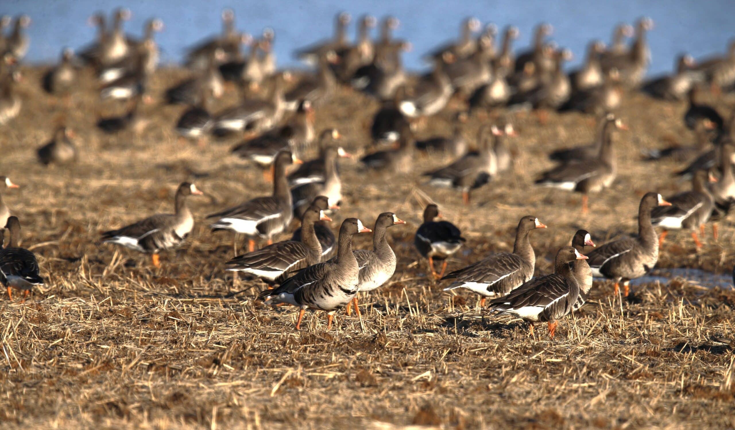
Greater white-fronted geese, or “specklebellies,” have been as prominent as ever in east-central Arkansas, according to observers there.
Dec. 13, 2023
Jim Harris
Managing Editor Arkansas Wildlife Magazine
Waterfowlers Wait for Conditions to Change
Arkansas is forecast to see mild daytime temperatures and only 2-3 days of rain in the remaining days of the second split of the 60-day waterfowl season, which runs through Saturday, Dec. 23. Weather conditions to the north of Arkansas don’t seem to favor much duck movement southward during that period, either, if waterfowl in those areas have access to enough food and habitat.
There are areas in South Dakota and Iowa this week still reporting peak numbers of ducks, according to reports supplied to Ducks Unlimited.
Arkansas Game and Fish Commission waterfowl biologists completed their aerial surveys of the state earlier this week for the annual December waterfowl density estimates — bad weather late last week pushed the work into Monday — and no complete data from the waterfowl survey was available by midweek this week. What we did hear were spotty reports of ducks.
It continues to be extremely dry in many areas that would normally be drawing good numbers of ducks by the point — the state really needs the annual mid- to late-December gully washer of 4-6 inches of rainfall over a several-day period to leave more sheetwater on the landscape and provide ducks with more access to good habitat. On a positive note, more water is gradually being seen in many of the AGFC’s moist-soil units and greentree reservoirs where pumping is available.
When planning ahead for the Dec. 23-24 weekend and applying for those permits this week (between Thursday afternoon and midnight Sunday), note that only Saturday, Dec. 23, is available for any WMA permits or WRICE private field permits. The second segment of the season will close at sunset Dec. 23 and reopen on Wednesday, Dec. 27. Waterfowl hunters who want to use the blinds at Sheffield Nelson Dagmar WMA Conway George Tract that are available on weekends only to youths will still want to apply this week for the Dec. 27 permits. Permit applications are $5. Hunters may only apply for one WRICE field per week; winners may take three additional hunters to hunt from 30 minutes before sunrise until sunset.
Permits are required to hunt Saturday, Dec. 23, in Steve N. Wilson Raft Creek Bottoms WMA and Cypress Bayou WMA’s Red Cut Slough units.
In the most recent report from the Missouri Department of Conservation about waterfowl numbers in the Show-Me State, Zachary Copeland of the MDC reported Dec. 4 that Missouri had seen a slight increase in duck numbers since late November, accompanied by larger numbers of Canada and snow geese making their way down. Temperature across the state had been slightly above average (as it had been in Arkansas) with precipitation level throughout much of the state being below average (again, mirroring Arkansas’s conditions). However, managers of conservation areas in Missouri noted a slight increase in water on many of the managed areas.
Missouri biologists counted 865,668 total ducks for the first week in December, compared with 128,220 snow geese, 12,420 greater white-fronted geese; and 6,267 Canada geese. The duck estimate was 10 percent higher than the previous five-year average and 14.6 percent higher than the previous 20-year average (755,484 ducks for the first week in December). Of that total, 614,577 were estimated to be mallards, or 4.7 percent higher than the previous five-year average for that point in the season, and 3.9 percent higher than the 20-year average.
AGFC plants 40,000 trees at Hurricane Lake WMA
Crews and contractors with the Arkansas Game and Fish Commission recently planted roughly 40,000 red oak seedlings in Henry Gray Hurricane Lake Wildlife Management Area to continue alleviating damage seen on the WMA’s greentree reservoirs in 2018.
More than 800 acres of bottomland hardwoods have succumbed to the effects of excessive flooding in the WMA in the last five years. Willow oaks, Nuttall oaks and many other trees beneficial to mallards and other wildlife were gradually being replaced by more water-tolerant and less desirable species, which was cause for alarm itself. But even those tree species saw a massive die-off in 2018 when nearly every tree in more than 200 acres suddenly died. Since that time, the deadening has expanded even further, but it was the catalyst for an immediate response by AGFC habitat biologists and wetland managers to speed up changes in infrastructure on the WMA and initiate plans to recover forest health in the area.
In addition to many projects to increase drainage on the WMA when the White River allows water to flow out of the old GTRs, habitat biologists led an effort to focus on reducing competition for the few remaining red oaks in the affected bottomland hardwoods to try to save them and enable their acorns to sprout naturally in the open areas left behind.
“We’ve conducted variable retention harvest on roughly 650 acres on the WMA in some of the heavily stressed areas,” AGFC habitat biologist Drew Green said.
Contractors removed undesirable species and some red oaks that were marked and checked by registered foresters working for the AGFC. Oaks that were removed were assessed as either past the point of recovery or were competing heavily with each other, not allowing proper growth.
“In those cases, we make a decision on one or two trees that will be most beneficial and clear out their competition so they can reach their potential,” AGFC Habitat Program coordinator Rob Willey said. “These are the trees that will produce acorns for wildlife and produce the next generation of forest.”
AGFC isn’t hedging all their bets on natural regeneration. Green led a crew of contractors to collect red oak acorns in 2021 and 2022 and, with the help of Baucum Nursery, grew oak seedlings that were from the original stock found at Hurricane Lake.
“Baucum Nursery really helped us out,” Green said. “They gave us our own bed to keep our trees separate from others they were growing. All of the trees we planted came from Hurricane originally.
Conditions weren’t favorable last year for planting the trees, but this summer’s dry spell enabled AGFC contractors to plant 168 acres with the propagated saplings. Approximately 40,000 saplings were planted, with 8,200 of those young trees being 2 years old.
“Those 2-year-old trees were chest high,” Willey said. “They should have a good jumpstart to get established.”
Green says he oversaw crews to cut out competing trees and shrubs that have begun to grow since the deadening earlier this year to prepare the area, and workers completed the planting fairly quickly.
“The herbaceous growth is still fairly thick in there, but these trees have a good chance of becoming the next forest,” Green said. “We also prepared another 164 acres of the area for planting next year and are budgeting the money to prep another 133 acres to be planted in 2026 if conditions allow.”
— Randy Zellers
New Cases of Avian Influenza Confirmed in Arkansas
Biologists conducting aerial surveys to generate waterfowl population estimates last week located a few small groups of dead snow geese and Ross’s geese in Arkansas, Craighead and Lonoke counties that were later collected and tested positive for Highly Pathogenic Avian Influenza. Additional suspected cases have been found in Prairie, Pulaski, Faulkner, Clay and Poinsett counties. While sightings are not as prevalent as last year’s outbreak, the continued presence of the disease on the landscape does create a need to update hunters and anyone who has domestic birds or poultry livestock.
The risk of humans contracting the disease remains low, but hunters can help further minimize that risk by following a few simple precautions. As a general precaution, hunters should use good hygiene practices when handling, cleaning and preparing harvested waterfowl.
Safety Guidelines for Hunters
- Harvest only waterfowl that act and look healthy. Do not handle or eat sick animals.
- Wear disposable gloves when handling and cleaning game and field dress outdoors or in a well-ventilated area. Wash hands thoroughly with soap and water afterward.
- Dispose of unwanted parts in a manner that prevents scavenging by domestic animals and wildlife.
- Thoroughly cook all game to an internal temperature of 165 degrees Fahrenheit before eating it.
- Do not feed pets or domestic animals uncooked portions of waterfowl.
The more concerning risk associated with HPAI is its potential for spillover to domestic poultry. Commercial poultry producers may want to implement biosecurity measures available at www.agriculture.arkansas.gov/livestock-poultry/poultry-health-npip-programs/biosecurity-standards-for-poultry-farms, but many Arkansans in rural areas have small flocks of domestic ducks and chickens as pets and a source for fresh free-range eggs.
Domestic birds should be completely isolated from wild birds or their parts. After handling waterfowl, hunters should change or clean clothing, shoes and other equipment before coming into contact with poultry, including commercial production facilities and backyard flocks.
Hunters and wildlife watchers who observe concentrations of sick or dead birds should visit www.agfc.com/education/avian-influenza with information about the species, number of birds affected and location.
More information on avian influenza is available at USDA APHIS’s website.
— Randy Zellers
- Southwest Arkansas
- Central Arkansas
- East-Central Arkansas
- Northwest Arkansas
- Northeast Arkansas
- Southeast Arkansas
Northeast Arkansas
Big Lake WMA
Map | Water Gauge | Weather Report
When the Ditch 81 extension gauge near Manila (upstream of the Big Lake north-end control structure) reads 17.5 feet, water is beginning to come over the north levee degrade on Big Lake WMA. When the Ditch 81 Extension gauge reads 18.0 feet or higher, the water level on the WMA will rise quickly and hunters should exercise caution while on the area. Be aware of underwater logs in boat runs and hangers in trees.
North Woods GTR
Habitat Type: Mast production
Water Level: Gauge reading at BoDoc is 235.5 feet; target level is 235.5 feet; 90% flooded.
South Woods GTR
Habitat Type: Mast production
Water Level: Gauge reading at 7-Mile is 234.3 feet; target level is 234.5 feet; 90% flooded.
Simmons Field
Habitat: Native vegetation
Water Level: 70% coverage.
Dave Donaldson Black River WMA
Map | Water Gauge | Weather Report
Waterfowl hunters should be aware of hangers and submerged logs within the boat runs and GTRs. Please exercise caution when accessing the area. Please remember to keep boats off the levees so AGFC personnel can access the area. Boats blocking access will be moved. Unattended trailers are not to be left overnight in parking areas. As of Dec. 6, the Black River level at Corning was 1.94 feet and holding.
Upper Island GTR
Habitat Type: Mast crop within the GTRs
Water Level: Current level is 269.6. Target level is 269.5; 100% flooded.
Lower Island GTR
Habitat Type: Mast crop within the GTRs
Water Level: Current level is 268.45 feet msl. Target level is 268.0; 100% flooded.
Upper Reyno GTR
Habitat Type: Mast crop within the GTRs
Water Level: Current level is 266.8 feet msl. Target level is 266.9; 95% flooded.
Lower Reyno GTR
Habitat Type: Mast crop within the GTRs
Water Level: Current level is 266.3 feet msl. Target level is 266.3; 100% flooded.
Winchester GTR
Habitat Type: Mast crop
Water Level: Current level is 263.25 feet msl. Target level is 263.7; 50% flooded.
Earl Buss Bayou DeView WMA
Map | Water Gauge | Weather Report
Boaters should use caution while using the Thompson Tract boat lane.
South Oliver GTR
Habitat Type: Bottomland hardwoods
Water Level: Current gauge reading is 0.0 feet. 0% flooded.
Thompson Tract GTR
Habitat Type: Bottomland hardwoods
Water Level: Current gauge reading is 0.0 feet. 0% flooded. The Thompson Tract GTR will be allowed to rise and fall naturally without the gates being operated later and partially this season. This action is an effort to help the next generation of forest.
Lake Hogue WRA
Habitat Type: Primarily deep open water
Water Level: Normal pool level
Shirey Bay Rainey Brake WMA
Map | Water Gauge | Weather Report
Waterfowl hunters should be aware of hangers and submerged logs within the boat runs and GTRs. Please exercise caution when accessing the area. In addition, hunters should allow safe passage when parking vehicles along roadsides. Vehicles blocking access will be moved.
Adam Brake GTR
Habitat Type: Mast production
Water Level: Water level is 238.2 feet msl with a target level of 240.0 feet msl. 45% flooded.
Rainey Brake GTR
Habitat Type: Mast production
Water Level: 40% flooded.
Eagle Pond GTR
Habitat Type: Mast production
Water Level: 60% flooded.
Phase III Moist-Soil Unit
Habitat Type: Japanese millet.
Water Level: 60% flooded.
Charles Crisp Moist-Soil Unit
Habitat Type: Japanese millet
Water Level: 0% flooded.
Ward Field Moist-Soil Unit
Habitat Type: Native vegetation
Water Level: 90% flooded.
River Field Moist-Soil Unit
Habitat Type: Japanese millet
Water Level: 100% flooded.
St. Francis Sunken Lands WMA
Map | Water Gauge | Weather Report
Hunt Area
Habitat Type: Bottomland hardwoods within the hunt area
Water Level: Water levels on St. Francis Sunken Lands for waterfowl season are dependent on flows from the St. Francis River. The target level for providing huntable timber is 212.0 feet msl at the Oak Donnick gauge. Current reading is 212.36 feet msl.
Snowden WRA
Habitat Type: Mixed grasses
Water Level: 10% flooded
Payneway WRA
Habitat Type: A, B, C and D pools have mixed smartweed and barnyard grasses. Moderate hardwoods within pools A, B and C as well.
Water Level: Pool A is at 0% coverage. Pool B is at 0%. Pool C is at 0%. Pool D is at 10%.
East-Central Arkansas
Henry Gray Hurricane Lake WMA
Map | Water Gauge | Weather Report
Hunters should call the Wildlife Hotline at 800-440-1477 for current road closures.
North Unit
Habitat Type: Bottomland timber
Water Level: The White River at Augusta as of Dec. 12 was 13.16 feet and rising. The water level at Glaise Creek is at 187.19 feet msl and stable. All structures on the North GTR will remain open during the 2023-24 season.
South Unit
Habitat Type: Bottomland timber
Water Level: The White River at Augusta is 13.16 feet and rising as of Dec 12. The water level at Glaise Creek is at 187.79 feet msl and stable. The South Unit now has no structures to close; water will flow freely throughout the unit.
Rex Hancock Black Swamp WMA
Map | Water Gauge | Weather Report
Hunters should call the Wildlife Hotline at 800-440-1477 for current road closures.
Gregory GTR
Habitat Type: Bottomland timber
Water Level: Cache River at Patterson was at 5.71 feet and falling on Dec 12.
Wiville Moist-Soil Unit
Habitat Type: Native vegetation
Water Level: 90% flooded
Sheffield Nelson Dagmar WMA
Map | Water Gauge | Weather Report
The Conway George units are currently available for hunting by applying for online permits. Youths may apply for Saturday and Sunday hunts, with one adult hunter allowed per one youth, up to four hunters in the blind. Wednesday permit hunts are available for adults (up to four hunters per party, three blinds available). Please visit www.agfc.com for maps, special regulations, permit application and draw dates. Hunters should call the Wildlife Hotline at 800-440-1477 for current road closures. The AGFC will not be putting boards in at Dagmar. Water coverage is dependent on river level.
Mud Slough GTR
Habitat Type: Bottomland timber
Water Level: 30% coverage
Apple Lake WRA (no hunting)
Habitat Type: Bottomland timber
Water Level: 40% coverage.
Conway George Waterfowl Unit A
Habitat Type: Native vegetation
Water Level: 90% coverage
Conway George Waterfowl Unit B
Habitat Type: Natural slough area with beneficial native wetland plants
Water Level: 90% coverage
Conway George Waterfowl Unit C
Habitat Type: Native vegetation
Water Level: 90% coverage
Dark Corner Waterfowl Unit 1
Habitat Type: Native vegetation
Water Level: 95%
Dark Corner Waterfowl Unit 2
Habitat Type: Native vegetation
Water Level: 70%
Dark Corner Waterfowl Unit 3
Habitat Type: Native vegetation
Water Level: No coverage
Steve N. Wilson Raft Creek Bottoms WMA
Hunting in Raft Creek Bottoms WMA requires participation on the online draw a week before the following weekend’s hunt. There is no online draw on Tuesdays and Thursdays, and permits are available at the boat accesses. Permits ARE required (via online application) on weekends, Tuesdays and Thursdays for the youth and mobility-impaired blinds and for the Magellan Tract. Visit agfc.com to apply for the online draw. There are no designated holes.
The White River gauge at Georgetown on Wednesday, Dec. 12, was 1.3 foot and falling
Map | Water Gauge | Weather Report
Unit A
Habitat Type: Native vegetation
Water Level: 100% coverage.
Unit B
Habitat Type: Native vegetation
Water Level: 50%
Unit C
Habitat Type: Native vegetation
Water Level: 45%
Unit D
Habitat Type: Native vegetation
Water Level: 70%
Unit E
Habitat Type: Native vegetation
Water Level: 80%
Unit F (Youth Area)
Habitat Type: Native vegetation
Water Level: 100%
Unit G
Habitat Type: Native vegetation.
Water Level: 0%
Unit H (Mobility-impaired blind)
Habitat Type: Native vegetation
Water Level: 100%
Unit I
Habitat Type: Native vegetation.
Water Level: 0%
Unit J (Cypert Tract)
Habitat Type: Native vegetation
Water Level: 75%
Unit K (Cypert Tract)
Habitat Type: Native vegetation
Water Level: 5%
Unit L (Cypert Tract)
Habitat Type: Native vegetation
Water Level: 0%
Unit M (Magellan Tract)
Habitat Type: Native vegetation
Water Level: 97%

Central Arkansas
Bell Slough WMA
Map | Weather Report
Bell Slough GTR
Flooding of the Bell Slough GTR is rainfall dependent. Gates were lowered in the GTR water control structure Nov. 17.
Habitat Type: Bottomland hardwood/cypress-tupelo
Water Level: 0%
Palarm Creek WRA
Habitat Type: Native moist-soil vegetation
Water Level: 65%
Craig D. Campbell Lake Conway Reservoir
Map | Weather Report
Due to planned renovation work to Craig D. Campbell Lake Conway Reservoir, water levels are currently 4-4.5 feet below normal pool on both Pierce and Dix creeks.
Cypress Bayou WMA
Map| Weather Report
Hunt Area
Habitat Type: Good mast crop
Water Level: 0% coverage.
Red Cut Slough Tract
Unit 1
Habitat Type: Native vegetation
Water Level: 5%
Unit 2
Habitat Type: Native vegetation
Water Level: 0%
Unit 3
Habitat Type: Native vegetation
Water Level: 90%
Unit 4
Habitat Type: Native vegetation
Water Level: 45%
Unit 5
Habitat Type: Native vegetation.
Water Level: 70%
Unit 6
Habitat Type: Open water reservoir
Water Level: 65%
Harris Brake WMA
Map | Weather Report
Upper GTR
Habitat Type: Good mast crop
Water Level: 100% coverage
Lower GTR
Habitat Type: Good mast crop.
Water Level: 15% coverage. The Harris Brake Lake valve was opened on Nov. 15 to begin supplemental flooding of both the Lower and Upper GTRs. Damage to one of the Lower GTRs water control structures is allowing water to drain from the Lower GTR and can’t currently be fixed. Sloughs and ditches within the Lower GTR unit will continue to hold water. However, the majority of the Lower GTR unit will stay drained due to the water control structure damage.
Holland Bottoms WMA
Map | Weather Report
Hunt Area
Habitat Type: Mast crop
Water Level: Most of the low lying areas scattered around the WMA have a few inches of water or are completely dry.
Lake Pickthorne WRA (no hunting)
Habitat Type: Native vegetation and millet
Water Level: The East Unit is at 70%, and the West Unit 100% flooded.

Northwest Arkansas
Dardanelle WMA
Map | Weather Report
McKennon Bottoms (half-day hunting)
Habitat Type: Native moist soil
Water Level: 100% coverage
Potter’s Pothole Hartman Waterfowl Unit (half-day hunting)
Habitat Type: Japanese millet and native moist-soil vegetation
Water Level: 100% coverage
Ed Gordon Point Remove WMA
Map | Weather Report
Flooding of waterfowl impoundments on Ed Gordon Point Remove WMA began Oct. 27 and will continue as long as water levels in Point Remove Creek allow.
Little Hole (Unit 1)
Habitat Type: Native moist-soil vegetation
Water Level: 90% flooded
Willow Island (Unit 2)
Habitat Type: Native moist-soil vegetation
Water Level: 90%
Red Gate (Unit 3)
Habitat Type: Native moist-soil vegetation
Water Level: 95%
Pig Trough (Units 4 and 5)
Habitat Type: Native moist-soil vegetation and Japanese millet
Water Level: 75%
Cedar Ridge (Unit 6)
Habitat Type: Native moist-soil vegetation
Water Level: 75%
Unit 7a
Habitat Type: Native moist-soil vegetation
Water Level: 80%
Unit 7b
Habitat Type: Native moist-soil vegetation
Water Level: 0%
Duck Trap (Units 8a, 8b and 8c)
8a
Habitat Type: Native moist-soil vegetation
Water Level: 90%
8b
Habitat Type: Native moist-soil vegetation
Water Level: 50%
8c
Habitat Type: Native moist-soil vegetation
Water Level: 50%
Unit 9
Habitat Type: Native moist-soil vegetation
Water Level: 60%
Controversy Corner (Unit 10)
Habitat Type: Native moist-soil vegetation and Japanese millet
Water Level: 90%
Remmel Marsh
Habitat Type: Native moist-soil vegetation
Water Level: 90%
Mud Pond (Unit 12)
Habitat Type: Native moist-soil vegetation
Water Level: 50%
Turkey Pond (Units 13a, 13b and 13c)
13a
Habitat Type: Native moist-soil vegetation
Water Level: 75%
13b
Habitat Type: Native moist-soil vegetation
Water Level: 40%
13c
Habitat Type: Native moist-soil vegetation
Water Level: 80%
Teeny Pond (Unit 14)
Habitat Type: Native moist-soil vegetation
Water Level: 20%
Salt Lick (Unit 15)
Habitat Type: Native moist-soil vegetation
Water Level: 60%
Bobby’s Pond (Unit 16)
Habitat Type: Native moist-soil vegetation
Water Level: 60%
Race Track (Unit 17)
Habitat Type: Native moist-soil vegetation
Water Level: 70%
Frog Bayou WMA
Map | Weather Report
Unit 1
Habitat Type: Japanese millet and moist soil vegetation
Water Level: 50% coverage.
Unit 2
Habitat Type: Native moist soil vegetation. Unit is rainfall dependent.
Water Level: 75%.
Unit 3
Habitat Type: Native moist soil vegetation
Water Level: 75%.
Unit 4
Habitat Type: Native moist soil vegetation
Water Level: 100%
Unit 5
Habitat Type: Native moist soil vegetation
Water Level: 100%
Unit 6
Habitat Type: Native moist soil vegetation
Water Level: 50%.
Unit 7
Habitat Type: Japanese millet and Native moist soil vegetation
Water Level: 100%
Galla Creek WMA
Map | Weather Report
Galla Creek
Habitat Type: Native moist soil vegetation and Japanese millet. Staged flooding of the waterfowl impoundment began Nov. 7, and the gate was raised again Dec. 1 to initiate the second stage of flooding. The gate will be raised to begin the final stage of flooding on Jan. 4.
Water Level: 70%
Nimrod Lloyd Millwood WMA
Map | Weather Report
Nimrod GTR
Habitat Type: The red oak mast crop is moderate this year as well as the desirable native vegetation growth. The water control structures were closed on Nov. 15.
Water Level: 5% flooded. Flooding of the area is rainfall dependent.
Ozark Lake WMA/Dyer Lake Water Unit
Weather Report
Dyer Lake Cells
Unit 1 Dyer main cell
Habitat Type: Japanese millet
Water Level: 100% coverage for both units
Unit 2 Dyer Road Cell
Habitat Type: Native moist soil
Water Level: 100% coverage
Unit 3 South Cell
Habitat Type: Chiwapa and Japanese millet
Water Level: 25% coverage
Unit 4 West Cell (rainfall dependent)
Habitat Type: Fallow disked
Water Level: 0% coverage
Petit Jean River WMA
Map | Water Gauge | Weather Report
Sorehead Moist-Soil Unit
Habitat Type: Native vegetation
Water Level: 100%
Blacklands Moist-Soil Unit
Habitat Type: Native vegetation. The red oak trees within the unit produced a moderate mast crop this year. Pumping of this unit is dictated by river levels. Due to the constant river level fluctuations, there is not a set date that this unit will be at full pool.
Water Level: 80%
Slaty Crossing Moist-Soil Unit
Habitat Type: Native vegetation
Water Level: 90%
Blacklands Duck Area
Habitat Type: Native vegetation
Water Level: 100%
Pullen Pond Marsh
Habitat Type: Native vegetation
Water Level: 10%. Flooding of the area is rainfall dependent.
Pond Creek GTR
Habitat Type: The red oak mast crop is moderate this year as well as the desirable native vegetation growth. The water control structures were closed Nov. 15.
Water Level: 10%. Flooding of this area is rainfall dependent.
Slaty GTR
Habitat Type: The red oak mast crop is moderate this year as well as the desirable native vegetation growth. The water control structures were closed Nov. 15.
Water Level: 10%. Flooding of this area is rainfall dependent.
Santa Fe GTR
Habitat Type: The red oak mast crop is moderate this year as well as the desirable native vegetation growth. The water control structures were closed Nov. 15.
Water Level: 5%. Flooding of this area is rainfall dependent.

Southwest Arkansas
Dr. Lester Sitzes III Bois d’Arc WMA
Map | Weather Report
Bois d’Arc Lake WRA
Habitat Type: Closed to hunting.
Water Level: Normal
Red Slough WRA
Habitat Type: Closed to hunting.
Water Level: 85% coverage
GTR
Habitat Type: Bottomland timber
Water Level: 95%
Little Grassy
Habitat Type: Native moist-soil vegetation
Water Level: 80%
Millwood Lake
Map | Water Gauge | Weather Report
Habitat Type: Natural vegetation
Water Level: Millwood is at 259.82 feet msl, 0.62 feet above normal conservation pool, as of Dec. 11.
Ozan WMA
Map | Weather Report
Flooding of all units is rainfall dependent.
Unit 1
Habitat Type: Native moist soil vegetation
Water Level: 70%
Unit 2
Habitat Type: Native moist-soil vegetation
Water Level: 40%
Unit 3
Habitat Type: Native moist-soil vegetation
Water Level: 30%
Unit 4
Habitat Type: Native moist-soil vegetation
Water Level: 50%
Unit 5
Habitat Type: Native moist-soil vegetation
Water Level: 20%
Sulphur River WMA
Mercer Bayou
Habitat Type: Natural vegetation
Water Level: 100%
Henry Moore WRA
Habitat Type: Closed to hunting.
Water Level: 60%
Southeast Arkansas
Beryl Anthony Lower Ouachita WMA
Map | Weather Report
Water Level: No water
Cut-Off Creek WMA
Map | Weather Report
Hunt Area
Habitat Type: Bottomland hardwood habitat
Water Level: No water
Pigeon Creek WRA
Habitat Type: Bottomland hardwood habitat
Water Level: No water
Freddie Black Choctaw Island WMA Deer Research Area
Map | Water Gauge | Weather Report
Habitat Type: Bottomland hardwood habitat
Water Level: Flooding is river dependent. Click on the Water Gauge link above for current Mississippi River levels. Use extreme caution when boating in the river.
The Freddie Black Choctaw Island WMA West Unit allows weekend permit hunting for youths (one adult per youth hunter); on Wednesdays, all ages may apply for a permit to hunt the blinds in the West Unit.
George H. Dunklin Jr. Bayou Meto WMA
Map | Water Gauge | Weather Report
The UGSG is reporting real-time water gauge readings at the headwater at each GTR within the George H. Dunklin Bayou Meto WMA. Click the Water Gauge link above for the WMA, and search for the particular GTR as noted.
NOTE: During the 2023-24 wintering period, all intentional flooding will be held at 178.5 feet msl, an elevation that will relieve stress on many trees such as red oaks that are showing signs of distress. Rain and increased flow into the WMA will allow water to rise above that level periodically. A good rule of thumb for comparing water levels to access into Bayou Meto: 176 feet msl – water breaking into sloughs and lower ditches; 177-177.5 feet msl – water beginning to break out of sloughs and lower ditches; 178 feet msl – water in most sloughs and ditches and entering into lower elevations in woods; 178.5 feet msl – most ditches and sloughs deep enough to boat and most boat ramps become serviceable; 179 feet msl or above – water expands to the higher elevations.
Upper Vallier GTR
Habitat Type: Bottomland hardwood habitat
Water Level: 178.13 feet msl and rising as of Dec. 12. See Gauge Link (Upper Vallier Headwater) for updated info.
Lower Vallier GTR
Habitat Type: Bottomland hardwood habitat
Water Level: 178.00 feet msl and rising as of Dec.12. See Gauge Link (Lower Vallier Headwater) for updated info.
Government Cypress GTR
Habitat Type: Bottomland hardwood habitat
Water Level: 178.24 feet msl and rising as of Dec. 12. See Gauge Link (Government Cypress Headwater) for updated info.
Buckingham Flats GTR
Habitat Type: Bottomland hardwood habitat
Water Level: 176.05 feet and falling as of Dec. 12. See Gauge Link (Buckingham Flats Headwater) for updated info.
Temple Island GTR
Habitat Type: Bottomland hardwood habitat
Water Level: 178.00 feet msl and steady as of Dec. 12. See Gauge Link (Temple Island Headwater) for updated info. Water too low for pumping.
Canon Brake
Habitat Type: Bottomland hardwood
Water Level: 163.81 feet msl as of Dec. 12. See Gauge Link (Canon Brake Headwater) for updated info.
Halowell WRA
Habitat Type: Moist soil
Water Level: Staggered flooding of units
Wrape Plantation WRA
Habitat Type: Moist soil
Water Level: Staggered flooding of units
Seven Devils WMA
Map | Weather Report
Hunt Area
Habitat Type: Bottomland hardwood habitat
Water Level: No water
Trusten Holder WMA
Map | Water Gauge | Weather Report
Habitat Type: Bottomland hardwood habitat
Water Level: Flooding is river dependent. Click on the Water Gauge link above for current Arkansas River levels.
Recent News

Subscribe to Our Weekly Newsletter E-mails
Don’t miss another issue. Sign up now to receive the AGFC Wildlife Weekly Newsletter in your mailbox every Wednesday afternoon (Waterfowl Reports are published weekly during waterfowl season and periodically outside the season). Fishing Reports arrive on Thursdays. Fill in the following fields and hit submit. Thanks, and welcome!