Poinsett County
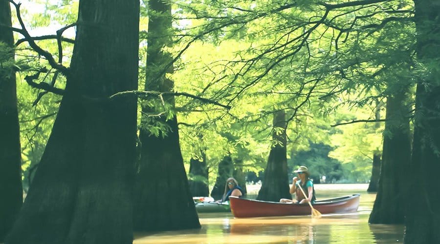
St. Francis Sunken Lands Water Trail
- From Jonesboro, follow I-555 and take exit 29 for AR-69 Trumann
- Turn left onto AR-69 and follow through Trumann for 8.2 miles
- Turn right onto County Road 888/Brody Road and travel 3.6 miles to the levee
- Turn left onto the levee and make an immediate right turn into the Iron Bridge boat ramp parking area
- From Jonesboro, follow I-555 and take exit 29 for AR-69 Trumann
- Turn left onto AR-69 and follow through Trumann for 3.1 miles
- Turn right onto Hwy 198/Stephen’s Landing Road and travel 1.4 miles
- Turn left onto the levee and immediately turn right onto Hinds Lane
- At the intersection, turn right toward Stephen’s Landing boat ramp
- From Jonesboro, follow I-555 and take exit 24 for AR-463 toward Trumann
- Turn right onto AR-463 S and travel 0.55 miles
- Turn left onto Tulot Road and continue on for 1.5 miles
- Turn right onto Oak Donnick Lane (a levee road). Travel 1.3 miles to the boat ramp.
Quick Facts
New Madrid earthquakes that rocked the region in 1811-12 created the Sunken Lands. Ground along the St. Francis River dropped 6-8 feet over an area of about 30 miles and was flooded – hence the name The Great Swamp.
Maps
The trail is only marked in critical locations. To follow the trail route, download a geo-referenced map of the trail in the Avenza App for mobile devices.
Georeferenced Map Instructions
- Download the free Avenza Map app from the App Store on mobile device.
- Choose a trail and tap on the geo-referenced map.
- Tap on the map again and choose “Open in Avenza Maps” or choose “More” and tap on the Avenza Map icon.
- Map is saved in Avenza Map app.
- A blue dot marks your location on the map.
- The trail map uses the phone’s GPS. If cell reception is poor, put phone on airplane mode to conserve power.
- Download the free Avenza Map app from the App Store on mobile device.
- Choose a trail and tap on the geo-referenced map.
- Tap on the three dots in the upper-right corner.
- Choose “Send File” and tap the Avenza Map icon.
- Map is saved in Avenza Map app.
- A blue dot marks your location on the map.
- The trail map uses the phone’s GPS. If cell reception is poor, put phone on airplane mode to conserve power.
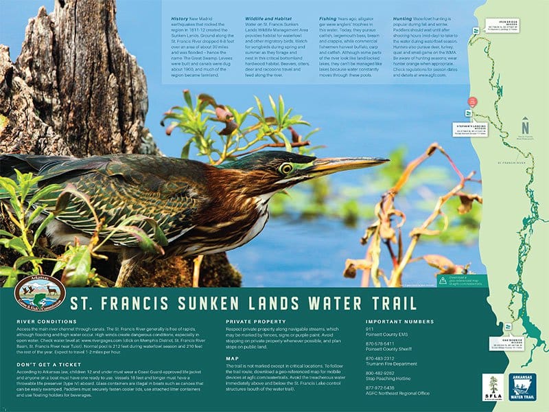


River Conditions
Access the main river channel through canals. The St. Francis River generally is free of rapids, although flooding and high water occur. High winds create dangerous conditions, especially in open water. Check water level at: http://rivergages.mvr.usace.army.mil (click on Memphis District, St. Francis River Basin, St. Francis River near Tulot). Normal pool is 212 feet during waterfowl season and 210 feet the rest of the year. Expect to travel 1-2 miles per hour.
History
New Madrid earthquakes that rocked the region in 1811-12 created the Sunken Lands. Ground along the St. Francis River dropped 6-8 feet over an area of about 30 miles and was flooded – hence the name The Great Swamp. Levees were built and canals were dug about 1900, and much of the region became farmland.
Emergency Numbers
Poinsett County EMS
911
Poinsett County Sheriff’s Office
870-578-5411
Trumann Fire Department
870-483-5151
Stop Poaching Hotline
833-356-0824
AGFC Jonesboro Regional Office
833-200-5199
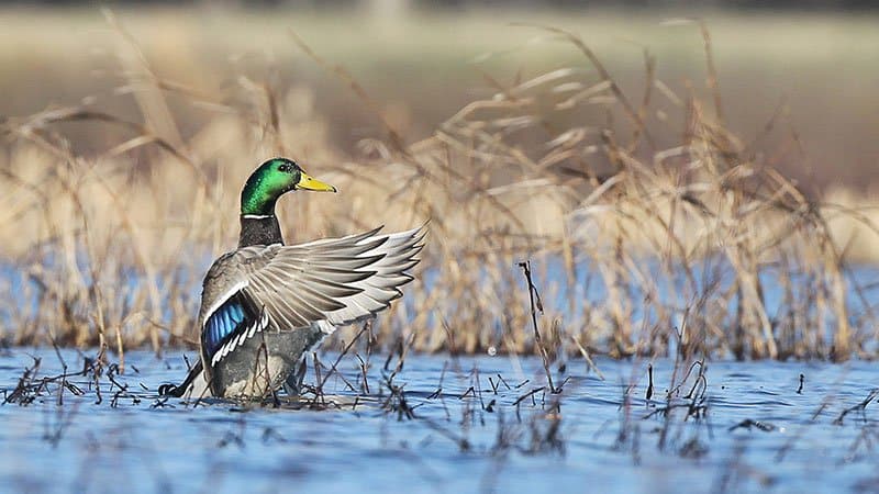
Water on St. Francis Sunken Lands Wildlife Management Area provides habitat for waterfowl and other migratory birds. Watch for songbirds during spring and summer as they forage and nest in this critical bottomland hardwood habitat. Beavers, otters, deer and raccoons travel and feed along the river.
Years ago, alligator gar were anglers’ trophies in this water. Today, they pursue catfish, largemouth bass, bream and crappie, while commercial fishermen harvest buffalo, carp and catfish. Although some parts of the river look like land-locked lakes, they can’t be managed like lakes because water constantly moves through these pools. Check Arkansas Game and Fish Commission fishing regulations.
Waterfowl hunting is popular during the fall and winter. Paddlers should wait until after shooting hours (mid-day) to take to the water during waterfowl season. Hunters also pursue deer, turkey, quail and small game on the WMA. Furbearer trapping is permissible on the WMA. Check the current Arkansas Hunting Guidebook for details and wear hunter orange when appropriate. Leash pets for their safety.
Respect private property along navigable streams, which may be marked by fences, signs or purple paint. Avoid stopping on private property whenever possible, and plan stops on public land.
According to Arkansas law, children 12 and under must wear a Coast Guard-approved life jacket and anyone on a boat must have one ready to use. Vessels 16 feet and longer must have a throwable life preserver (type IV) aboard. Glass containers are illegal in boats such as canoes that can be easily swamped. Paddlers must securely fasten cooler lids, use attached litter containers and use floating holders for beverages.