Arkansas Wildlife Weekly Waterfowl Report
BY Jim Harris
ON 12-14-2022
Dec. 14, 2022
Jim Harris
Managing Editor Arkansas Wildlife Magazine
Long-awaited Rainfall Arrives Along With Cold-weather Push for Waterfowl
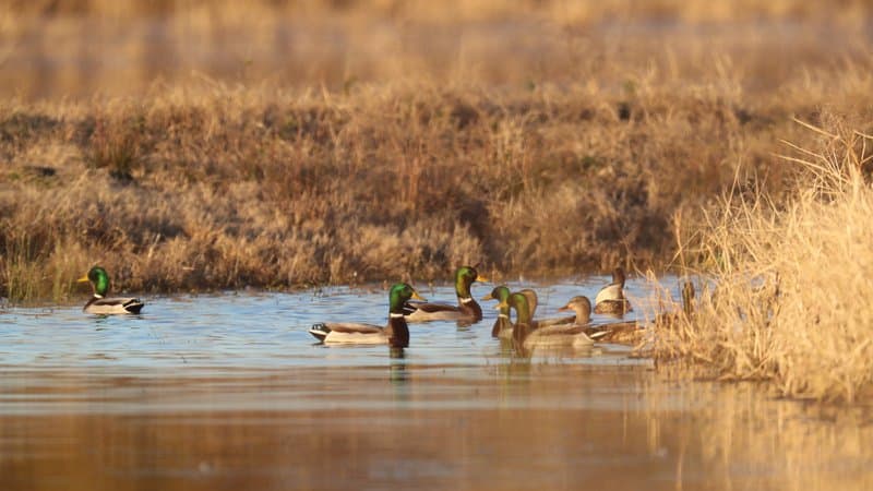
Arkansas still hasn’t seen the wished-for gullywasher of 4-6 inches of rainfall across the state yet to flood the landscape and make hunting ideal, but the 2 inches or so of rainfall dropped around central Arkansas since Sunday has helped ease the dry conditions, and that should afford migrating ducks more habitat access as waterfowl hunters move toward the second weekend of the 60-day season’s second section. Combine that with an arctic front that is moving down through the central U.S. in the next few days, along with below-average temperatures expected over the next week or so, according to the National Weather Service, and we could see a good push of ducks.
Minor flooding was being noted around Patterson on the Cache River on Wednesday morning.
“Yeah, this was enough to put some water in the fields and provide some runoff for a few days, but we’re still needing that really big rainfall to provide a huge amount of habitat and help move around a huge number of ducks,” Luke Naylor, the Arkansas Game and Fish Commission’s Wildlife Management Division chief, said.
The AGFC’s public hunting areas, both greentree reservoirs and moist-soil units thoughout the state, are filling up with the latest precipitation. Also, this new water should allow conditions on all the WRICE Program fields to be put into use in coming weekends. Some of the public hunting units of Steve N. Wilson Raft Creek Bottoms WMA that regular flooding/pumping was unable to reach with the dry conditions and low river levels now show 30 percent coverage, to go along with other units that have been well-covered in water so far. Dave Donaldson Black River WMA is filled in most areas, and the Big Lake WMA units are finally beginning to have some coverage.
One important note for hunters who apply for permit hunting on the WRICE fields or the WMAs that require permits to hunt: the second portion of the season closes at sunset Dec. 23, meaning that the calendar has thrown hunters for a rare holiday loop this year, with the season closed for an entire weekend (Dec. 24-25). However, hunters will still want to apply for permits that will be available when the season resumes Monday, Dec. 26, with several permit options (other than WRICE) available at WMAs between Dec. 27-29 (such as the youth blinds at Dagmar that are open to all hunters on Wednesdays). To get those spots, you’ll need to apply between 3 p.m. this Thursday and midnight Sunday.
Count Delayed by Overcast
The AGFC’s aerial survey team had hoped to make its annual December waterfowl count last week, but cloud conditions and other inclement weather kept most of the group grounded, and set the work back a week. It will now be later this week or early next week before the data from survey can be compiled to provide an estimate of the number of birds now in Arkansas. “This is the worst weather I’ve seen for our aerial survey counts since I’ve been here,” said Luke Naylor, who headed up the waterfowl program as coordinator for 16 years until his June promotion to chief of the Wildlife Management Division.
As a help for what might be headed Arkansas’s way in the migration, Duck-tracker.com provides regularly updated duck migration maps and reports from states above Arkansas (mostly Missouri and Iowa), derived from those states’ agency reports. Its latest map on Sunday, Dec. 11, showed biggest increases in migration from the middle of Missouri through its southeast corner. It noted:
* Iowa losing birds: Only 2 Iowa counties are reporting an increase in duck migration counts over the past two weeks while all others are reporting large declines. This decrease may not be significant to Iowa hunters given that the season in the state is winding down, but waterfowlers south of the state might be interested to see that the last major push of this years migration is making its way down the flyway.
* Large number of ducks along the Mississippi River, but they’ve been there a while: When looking at the map, it’s easy to see the vast concentration green along the Mississippi River. But a closer look reveals that although they are reporting increases in those areas, the percentage of change isn’t much. We are hearing several reports of “very stale” birds in those areas.
Duck Season Social Provides Discussion Fodder
The Arkansas Game and Fish Foundation and several waterfowl hunting sponsors brought together a few hundred members of the Foundation and other hunters for a supper, drinks, raffle and socializing last Wednesday, Dec. 7, at the Westwind event center, just off Interstates 430 and 40. It drew current and former AGFC commissioners as well. It also provided the rare occasion where some of the state’s best minds surrounding waterfowl hunting could discuss a variety of topics of interest to the duck hunter in casual Q&A format.
The event proceeds went to the Arkansas Game and Fish Foundation Legacy Campaign, with 2022 dollars earmarked for greentree reservoir restoration and other waterfowl habitat initiatives.
The panel included Luke Naylor, who has served as waterfowl program coordinator at the AGFC for several years and recently was named chief of the AGFC’s Wildlife Management Division; Jim Ronquest, vice president of development for Drake Waterfowl; Doug Osborne, waterfowl biologist at UA-Monticello and director at Five Oaks Research Center; and Rusty Creasey, manager of Coca-Cola Woods in McCrory. Jonathan Wilkins, founder of Black Duck Revival at Brinkley, served as a well-informed leader of the discussion panel.
The outbreak of Highly Pathogenic Avian Influenza was touched on, but the crowd asking questions seemed most concerned about the long-term outlook of duck hunting in Arkansas. Osborne’s discussion about banding of ducks in Arkansas and where those ducks are being harvested was a topic that got many in the room to perk up.
When reached this week about such studies, Naylor noted, “The recovery of banded birds is a really interesting topic of study and discussion. There is ongoing research at the University of Missouri that will shed a lot of light on those questions and will be covered at a later date when all the research is in. But I know there is some really cool research being done.”
A rise in pintail production in the prairies (both U.S. and Canada), noted by a panel, seems to traditionally indicate a good migration overall of ducks to Arkansas, because it also indicates a good production of pintails and other ducks in Saskatchewan and the Canadian prairie. Naylor explained later, “Pintails seem to have had pretty good production on the prairies this year, and if they did well, that’s probably a good indicator for some other species that are more prolific nesters and more prolific in breeding. Pintails are kind of at the low end of the spectrum (in nesting and breeding) so that bodes well for others.”
It was concerning to some waterfowl followers in the summer when U.S. Fish and Wildlife Service duck counts from North Dakota prairie potholes were down some from the long-term average, and those were attributal to recent drought conditions in that area, but the panelists noted that Saskatchewan in contrast had a wetter period this year during the ducks’ breeding time. That can change quickly, and Naylor noted that the area cited for being wetter than it’s been is now dry again.
“They’ve been dry up there for a while, but this summer, this late spring and early summer, in southeast Saskatchewan, Manitoba, part of the Dakotas all got substantial water and had pretty good nesting habitat conditions,” he said. “It wasn’t true in western Saskatchewan and Alberta. But where it was wet should have led to better duck production and more hatch hear ducks in the fall flight moving through right now.”
The hunters and panelists also noted what seems to be a recent trend that Arkansas is seeing “older birds,” and hence smarter birds — wary of hunting areas, more likely to fly at night under increasing moonlight to feed before returning to roost in the day, and to favor the resting areas — compared to hatch-year ducks.
“Production (of hatch-year birds) has been low for a while,” Naylor said, “indicated by the age ratios that we get from the Wing-bee counts we do, comparing hatch-year birds to adult birds. Age rations have been declining and have been pretty low for quite a few years. Hunters harvested fewer hatch-year birds.
“Young birds are what makes everybody appear to be an expert duck hunting. They are a lot more susceptible to harvest and can lead to good production, can lead to better hunter success and higher harvest in some years. It makes it easier to hunt.”
But with this recent good news, starting with more pintail production, “We should probably see higher age rations and more hatch-year harvest this season because of the better production on the prairies.”
One of the panelists brought up the AGFC’s work to restore greentree reservoirs, in part to provide ducks more habitat and food resources. His question sounded exactly like ones we’ve heard at GTR meetings in the past: When he’s harvested ducks in flooded timber, he didn’t notice any acorns in the duck’s craw. Naylor seemed to have hit the exasperation point in address that fallacy, as he noted hunters are killing ducks when they just arrive among the trees and are seeking the acorns. “Wait around a couple of hours after they’ve arrived and then kill them (and see),” he said. Biological studies clearly show the need for and the demand ducks have for acorns in their diet. and they get them from GTRs with healthy oaks that produce the acorns ducks can access (such as red oaks and willow oaks, which are damage to the point of dying when standing in stagnant water through their non-dormant season).
Along those same lines, it was noted that ducks have been migrating along what we know now as the Mississippi and Central flyways for more than a million years (eons ago, the massive Ohio River ran west of Crowley’s Ridge and the equally massive Mississippi River ran to the east), and we’ve been here for a tiny fraction of that time, where the human species began settling where the rivers receded and began adding to their food sources with our agricultural changes to the landscape. Rice, for instance, wasn’t a native crop on the Grand Prairie until a century ago. Trees and their acorns, and macro-nutrients found in the moist-soil units, and bugs and invertebrates were what they feasted on long before humans were around and farming. In the grand scheme of things, that’s what they’ll continual to look for as the healthiest nutrition.
To paraphrase what Buck Jackson, the AGFC’s wetlands coordinator, says: Rice and such annual crops give ducks the instant carb boost and are like fields of Snickers bars to them, and indeed they have learned to search out and feast in such agri fields for the carbs, but ultimatelyducks need also the good nutrients to survive the annual migration and produce more ducks.
Watch for Avian Flu Cases
Hunters are being asked again to maintain a vigilant lookout for any birds that might be infected or suffering from Highly Pathogenic Avian Influenza.
HPAI continues to be a concern for wildlife biologists, especially with much evidence of it seen recently among migrating snow geese and other waterfowl and wintering birds in eastern Arkansas. Hunters, outdoors enthusiasts and wildlife watchers are asked to report instances of dead or sick waterfowl that they encounter in the wild. The risk of humans contracting the disease remains low, but hunters can help further minimize that risk by following a few simple precautions (see below). Anyone who observes concentrations of sick or dead birds should report their sighting by using the AGFC’s Avian Influenza Reporting Form.
More information on avian influenza information is available at AGFC, Ducks Unlimited, and USDA APHIS’s website.
Risk to Humans Is Very Low
The risk for humans to contract HPAI is still very low, and cases where the disease has infected humans came from situations where working conditions caused people to be in close proximity to infected poultry.
As a general precaution, hunters should use good hygiene practices when handling, cleaning and preparing harvested waterfowl.
Safety Guidelines for Hunters:
- Harvest only waterfowl that act and look healthy. Do not handle or eat sick animals.
- Wear disposable gloves when handling and cleaning game and field dress outdoors or in a well-ventilated area. Wash hands thoroughly with soap and water afterward.
- Dispose of unwanted parts in a manner that prevents scavenging by domestic animals and wildlife.
- Thoroughly cook all game to an internal temperature of 165 degrees Fahrenheit before eating it.
- Do not feed pets or domestic animals uncooked portions of waterfowl.
The more concerning risk associated with HPAI is its potential for spillover to domestic poultry.
Agricultural officials urge poultry producers to implement biosecurity measures around their flocks, especially during periods of waterfowl migration, but hunters who have contact with poultry should use extra caution. Avoid contact between poultry and wild birds or their parts. After handling waterfowl, change or clean clothing, shoes and other equipment before coming into contact with poultry, including commercial production facilities and backyard flocks.
Bag Limits
Remember: Daily bag limits are the same as seen in recent years. Hunters make harvest a bag limit of 6 ducks, which may include no more than 4 mallards (2 hens), 1 scaup, 3 wood ducks, 1 pintail, 2 redheads, 2 canvasbacks, 2 black ducks or 1 mottled duck. Beyond those exceptions, the limit is up to 6 ducks of a species, including teal. The merganser daily bag limit is 5, with only 2 hooded mergansers allowed. The daily bag limit for coots is 15. Non-lead shot must be used for waterfowl hunting in Arkansas. The possession limit for ducks, coots and mergansers is three times the daily bag limit. Hunting for geese reopens Dec. 10 as well. The daily bag limit for greater white-fronted geese 3, up from last year’s 2 birds per day. The daily limit for snow, blue and Ross’s geese is 20 per day.
Waterfowl season reopens 30 minutes before sunrise Saturday, Dec. 10. The second closing “split” is for the Christmas holiday, Dec. 24-25, with the final portion of duck season reopening 30 minutes before sunrise Dec. 26. The season closes at sunset Jan. 31.
Northeast Arkansas
Big Lake WMA
Map | Water Gauge | Weather Report
When the Ditch 81 extension gauge near Manila (upstream of the Big Lake north-end control structure) reads 17.5 feet, water is beginning to come over the north levee degrade on Big Lake WMA. When the Ditch 81 Extension gauge reads 18.0 feet or higher, the water level on the WMA will rise quickly and hunters should exercise caution while on the area. Be aware of underwater logs in boat runs and hangers in trees.
North Woods GTR
Habitat: Mast production is good.
Water Level: Gauge reading at BoDoc is 235.2 feet msl; target level is 235.5 feet with 15% flooded.
South Woods GTR
Habitat: Mast production is fair.
Water Level: Gauge reading at 7-Mile is 233.3 feet msl; target level is 234.5 feet with 70% flooded.
Simmons Field
Habitat: Native production is good in the middle and south fields.
Water Level: 20% coverage.
Dave Donaldson Black River WMA
Map | Water Gauge | Weather Report
Waterfowl hunters should be aware of hangers and submerged logs within the boat runs and GTRs. Please exercise caution when accessing the area. Please remember to keep boats off the levees so AGFC personnel can access the area. Boats blocking access will be moved. Unattended trailers are not to be left overnight on parking areas. As of Dec. 5, the current Black River level is 2.8 feet and holding.
Upper Island GTR
Habitat: Mast crop is moderate within the GTRs.
Water Level: Current level is 269.7 feet msl. Target level is 269.5; 100% flooded.
Lower Island GTR
Habitat: Mast crop is moderate within the GTRs.
Water Level: Current level is 268.65. Target level is 268.0; 100% flooded.
Upper Reyno GTR
Habitat: Mast crop is moderate within the GTRs.
Water Level: Current level is 267.1. Target level is 266.9; 100% flooded.
Lower Reyno GTR
Habitat: Mast crop is moderate within the GTRs.
Water Level: Current level is 266.6 feet msl. Target level is 266.3; 100% flooded.
Winchester GTR
Habitat: Mast crop is moderate within the GTRs.
Water Level: Current level is 263.3 feet msl. Target level is 263.7; 70% flooded.
Earl Buss Bayou DeView WMA
Map | Water Gauge | Weather Report
Boaters should use caution while using the Thompson Tract boat lane.
South Oliver GTR
Habitat: Mast production is good.
Water Level: 0% flooded. No water is currently on the gauge. However, there is shallow water present in the natural sloughs.
Thompson Tract GTR
Habitat: Mast production is good.
Water Level: 0% flooded. No water is currently on the gauge. However, there is water in the boat lane and around the underground gass line. The Thompson Tract GTR will be allowed to rise and fall naturally without the gates being operated later and partially this season. This action in an effort to help the next generation of forest.
Lake Hogue WRA
Habitat: Primarily deep open water habitat.
Water Level: Normal pool level.
Shirey Bay Rainey Brake WMA
Map | Water Gauge | Weather Report
Waterfowl hunters should be aware of hangers and submerged logs within the boat runs and GTRs. Please exercise caution when accessing the area. In addition, hunters should allow safe passage when parking vehicles along roadsides. Vehicles blocking access will be moved.
Adam Brake GTR
Habitat: Mast production is good.
Water Level: Water level is 238.6 feet msl with a target level of 240.0 feet msl; 55% flooded.
Rainey Brake GTR
Habitat: Mast production is good.
Water Level: 80% flooded.
Eagle Pond GTR
Habitat: Mast production is good.
Water Level: 75% flooded.
Phase III Moist-Soil Unit
Habitat: Fair wetland-type vegetation.
Water Level: 75% flooded.
Charles Crisp Moist-Soil Unit
Habitat: Fair wetland-type vegetation.
Water Level: 30% flooded.
Ward Field Moist-Soil Unit
Habitat: Good wetland-type vegetation.
Water Level: 100% flooded.
River Field Moist-Soil Unit
Habitat: Good wetland-type vegetation.
Water Level: 100% flooded.
St. Francis Sunken Lands WMA
Map | Water Gauge | Weather Report
Hunt Area
Habitat: Good mast production within the hunt area.
Water Level: Water levels on St. Francis Sunken Lands for waterfowl season are dependent on flows from the St. Francis River. The target level for providing huntable timber is 212.0 feet msl at the Oak Donnick gauge. Current reading is 213.77 feet msl.
Snowden WRA
Habitat: Mixed grasses.
Water Level: 0% flooded.
Payneway WRA
Habitat: A, B, C and D pools have mixed smartweed and barnyard grasses. Moderate mast is available within pools A, B and C as well.
Water Level: Pool A is at 0% coverage. Pool B is at 0%. Pool C is at 0%. Pool D is at 0%.
East-Central Arkansas
Henry Gray Hurricane Lake WMA
Map | Water Gauge | Weather Report
Hunters should call the Wildlife Hotline at 800-440-1477 for current road closures.
North Unit
Habitat: Good mast crop.
Water Level: The White River at Augusta as of Monday, Dec. 12, was 21.04 feet (a jump of 5 feet over this time last week) and rising. The water level at Glaise Creek is 188.13 feet and rising. All structures on the North GTR will remain open during the 2022-23 season.
South Unit
Habitat: Fair mast crop.
Water Level: The White River at Augusta is 21.04 feet and rising. The water level at Glaise Creek is 188.13 feet and rising. All structures on the South Unit are open.
Rex Hancock Black Swamp WMA
Map | Water Gauge | Weather Report
Hunters should call the Wildlife Hotline at 800-440-1477 for current road closures.
Gregory GTR
Habitat: Good mast crop.
Water Level: Little water available (Cache River at Patterson was at 8.71 feet on Dec. 12.)
Wiville Moist-Soil Unit
Habitat: Good stand of native vegetation.
Water Level: 90% flooded.
Sheffield Nelson Dagmar WMA
Map | Water Gauge | Weather Report
The Conway George units are currently available for hunting by applying for online permits. Youths may apply for Saturday and Sunday hunts in the Conway George tracts, with one adult hunter allowed per one youth, up to four hunters in the blind. Hunters of any age may apply for Wednesday permit hunts in the Conway George tracts. Please visit www.agfc.com for maps, special regulations, permit application and draw dates. Hunters should call the Wildlife Hotline at 800-440-1477 for current road closures. The AGFC will not be putting boards in at Dagmar. Water coverage is dependent on river level.
Mud Slough GTR
Habitat: Good mast crop.
Water Level: 20% coverage.
Apple Lake WRA (no hunting)
Habitat: Good mast crop.
Water Level: 20% coverage.
Conway George Waterfowl Unit A
Habitat: Good stand of native vegetation.
Water Level: 90% coverage
Conway George Waterfowl Unit B
Habitat: Natural slough area with beneficial native wetland plants.
Water Level: 90% coverage
Conway George Waterfowl Unit C
Habitat: Good stand of native vegetation.
Water Level: 90% coverage
Dark Corner Waterfowl Unit 1
Habitat: Good stand of native vegetation.
Water Level: 95% coverage
Dark Corner Waterfowl Unit 2
Habitat: Good stand of native vegetation.
Water Level: 40% coverage
Dark Corner Waterfowl Unit 3
Habitat: Good stand of native vegetation.
Water Level: 10% coverage
Steve N. Wilson Raft Creek Bottoms WMA
Hunting in Raft Creek Bottoms WMA requires participation on the online draw a week before the following weekend’s hunt. There is no online draw on Tuesdays and Thursdays, and permits are available at the boat accesses. Permits ARE required (via online application) on weekends, Tuesdays and Thursdays for the youth and mobility-impaired blinds and for the Magellan Tract. Visit agfc.com to apply for the online draw. There will be no designated holes this season.
The White River gauge at Georgetown on Tuesday, Dec. 13, was 7.6 feet , going to 8 feet and then falling.
Unit A
Habitat: Excellent stand of native vegetation.
Water Level: 100% coverage.
Unit B
Habitat: Excellent stand of millet and native vegetation.
Water Level: 100%
Unit C
Habitat: Good stand of native vegetation.
Water Level: 100%
Unit D
Habitat: Good stand of native vegetation.
Water Level: 100%
Unit E
Habitat: Excellent stand of millet and native vegetation.
Water Level: 90%
Unit F (Youth Area)
Habitat: Good stand of millet and native vegetation.
Water Level: 100%
Unit G
Habitat: Habitat conditions are poor.
Water Level: 30%
Unit H (Mobility-impaired blind)
Habitat: Excellent stand of native vegetation.
Water Level: 100%
Unit I
Habitat: Habitat conditions are poor.
Water Level: 30%
Unit J (Cypert Tract)
Habitat: Excellent stand of native vegetation.
Water Level: 85%
Unit K (Cypert Tract)
Habitat: Excellent stand of native vegetation.
Water Level: 15%
Unit L (Cypert Tract)
Habitat: Fair stand of native vegetation.
Water Level: 10%
Unit M (Magellan Tract)
Habitat: Good stand of native vegetation.
Water Level: 100%
Central Arkansas
Bell Slough WMA
Map | Weather Report
The Bell Slough GTR is primarily rainfall dependent with the exception of a limited amount of water that the AGFC can back in and catch from Palarm Creek.
Bell Slough GTR
Habitat: Fair mast crop.
Water Level: 15%.
Palarm Creek WRA
Habitat: Rest area was heavily disked late this year and millet crop did not take before the early frost.
Water Level: 80%
Craig D. Campbell Lake Conway Reservoir
Map | Weather Report
Habitat and water levels are normal on both Pierce and Dix creeks.
Cypress Bayou WMA
Hunt Area
Habitat:
Good mast crop.
Water Level: 50% coverage.
Red Cut Slough Tract
Unit 1
Habitat:
Habitat conditions are poor.
Water Level: 5%
Unit 2
Habitat:
Excellent stand of millet and native vegetation
Water Level: 5%
Unit 3
Habitat:
Good stand of millet and native vegetation
Water Level: 50%
Unit 4
Habitat: Good stand of millet and native vegetation.
Water Level: 100%
Unit 5
Habitat:
Good stand of native vegetation.
Water Level: 100%
Unit 6
Habitat:
Good stand of native vegetation.
Water Level: 80%
Harris Brake WMA
Upper GTR
Habitat: Good mast crop.
Water Level: 100% coverage.
Lower GTR
Habitat: Good mast crop.
Water Level: 20% coverage. The Harris Brake Lake valve was opened Nov. 15 to begin supplemental flooding of both the Lower and Upper GTRs. Unfortunately, damage to one of the Lower GTR’s water control structures is allowing water to drain from the Lower GTR and can’t currently be fixed. The Lower GTR will mostly likely drain completely unless the Fourche La Fave overtops the levee and floods the GTR.
Holland Bottoms WMA
Hunt Area
Habitat: Good mast crop.
Water Level: Some sloughts on the WMA are starting to be refilled with rainwater.
Lake Pickthorne WRA (no hunting)
Habitat: Excellent crop of native vegetation and millet.
Water Level: The West Unit is 85% flooded.
Northwest Arkansas
Dardanelle WMA
McKennon Bottoms (half-day hunting)
Habitat: Good stand of native moist-soil vegetation.
Water Level: 100% coverage
Potter’s Pothole Hartman Waterfowl Unit (half-day hunting)
Habitat: West cell has a poor stand of moist-soil vegetation. East cell has an average stand of moist-soil vegetation.
Water Level: 100% coverage
Ed Gordon Point Remove WMA
Pumping of waterfowl impoundments began Oct. 31 and will continue as water levels in Point Remove Creek allow. Duck Use on the WMA has been low to moderate.
Little Hole (Unit 1)
Habitat: Japanese millet.
Water Level: 20% flooded.
Willow Island (Unit 2)
Habitat: Japanese millet and natural vegetation.
Water Level: 100%
Red Gate (Unit 3)
Habitat: Natural vegetation
Water Level: 85%
Pig Trough (Units 4 and 5)
Habitat: Natural vegetation.
Water Level: 70%
Cedar Ridge (Unit 6)
Habitat: Japanese millet.
Water Level: 75%
Unit 7a
Habitat: Natural vegetation.
Water Level: 80%
Unit 7b
Habitat: Japanese millet and natural vegetation.
Water Level: 0%
Duck Trap (Units 8a, 8b and 8c)
8a
Habitat: Natural vegetation and Japanese millet.
Water Level: 15%
8b
Habitat: Japanese millett and natural vegetation.
Water Level: 70%
8c
Habitat: Natural vegetation.
Water Level: 75%
Unit 9
Habitat: Natural vegetation.
Water Level: 95%
Controversy Corner (Unit 10)
Habitat: Natural vegetation.
Water Level: 80%
Remmel Marsh
Habitat: Natural vegetation.
Water Level: 90%
Mud Pond (Unit 12)
Habitat: Natural vegetation and Japanese millet.
Water Level: 60%
Turkey Pond (Units 13a, 13b and 13c)
13a
Habitat: Natural vegetation and Japanese millet.
Water Level: 60%
13b
Habitat: Natural vegetation.
Water Level: 70%
13c
Habitat: Natural vegetation and Japanese millet.
Water Level: 70%
Teeny Pond (Unit 14)
Habitat: Natural vegetation.
Water Level: 0%
Salt Lick (Unit 15)
Habitat: Natural vegetation.
Water Level: 60%
Bobby’s Pond (Unit 16)
Habitat: Natural vegetation.
Water Level: 60%
Race Track (Unit 17)
Habitat: Natural vegetation.
Water Level: 85%
Frog Bayou WMA
Due to the dry summer, several units have been fallow-disked in preparation for next season.
Unit 1
Habitat: Good stand of moist-soil vegetation in the upper end, while lower end has been fallow-disked.
Water Level: 100% coverage
Unit 2
Habitat: Has been fallow-disked. Unit is rainfall dependent.
Water Level: 100% flooded.
Unit 3
Habitat: Average stand of moist-soil vegetation on the upper end; lower end has been fallow-disked.
Water Level: 100%
Unit 4
Habitat: Good stand of moist-soil vegetation and planted millet
Water Level: 100%
Unit 5
Habitat: Good stand of moist-soil vegetation on the upper end; lower end has been planted with Japanese millet.
Water Level: 100%
Unit 6
Habitat: Good stand of moist-soil vegetation. Lower end has been fallow-disked.
Water Level: 70% and pumping.
Unit 7
Habitat: Good stand of moist-soil vegetation.
Water Level: 100%
Galla Creek WMA
Galla Creek GTR
Habitat: Good stands of native vegetation and Japanese millet. Staged flooding of the area will continue throughout the waterfowl season. The gate will be raised for the final time by Jan. 1, 2023.
Water Level: 60% flooded.
Nimrod Lloyd Millwood WMA
Nimrod GTR
Habitat: The red oak mast crop is moderate this year as well as the desirable native vegetation growth. Due to abnormally dry conditions, this area is not expected to fill up as fast as in previous years. The water control structures were closed Nov. 15.
Water Level: 25% flooded. Flooding of the area is rainfall dependent.
Ozark Lake WMA/Dyer Lake Water Unit
Dyer Lake Cells
Unit 1 Dyer main cell
Habitat: Good stand of moist-soil vegetation.
Water Level: 100% coverage for both units
Unit 2 Dyer Road Cell
Habitat: Poor stand of moist-soil vegetation due to dry conditions over the summer.
Water Level: 100% coverage
Unit 3 South Cell
Habitat: Good stand of moist-soil vegetation and volunteer millet.
Water Level: 25% coverage
Unit 4 West Cell (rainfall dependent)
|Habitat: Good stand of moist-soil vegetation and volunteer millet.
Water Level: 5% coverage
Petit Jean River WMA
Map | Water Gauge | Weather Report
Sorehead Moist-Soil Unit
Habitat: This unit was able to grow a great stand of desirable native vegetation this year. The Kingfisher Lake water control structure valve was opened Nov. 15 to help flood this area.
Water Level: 100%
Blacklands Moist-Soil Unit
Habitat: The red oak mast crop is moderate this year as well as the desirable native vegetation growth. Millet planting was attempted this year, but the dry conditions prevented growth. The recent rains have put enough water in the river to start pumping last week.
Water Level: 100%.
Slaty Crossing Moist-Soil Unit
Habitat: Due to ongoing waterfowl habitat enhancement projects, this unit was not able to grow a desirable native vegetation crop or millet crop this year. The recent rains have put enough water in the river to start pumping last week.
Water Level: 100%
Blacklands Duck Area
Habitat: The red oak mast crop is moderate this year as well as the desirable native vegetation growth. Millet planting was attempted this year, but the dry conditions prevented growth. The Kingfisher Lake water control structure valve was to be opened Nov. 15 to help flood the area.
Water Level: 100%
Pullen Pond Marsh
Habitat: Due to ongoing waterfowl habitat enhancement projects, parts of the central section and western section of this area is bare ground. Most of the area has a great stand of desirable native vegetation. The water control structures were closed on Nov. 4.
Water Level: 10%. Flooding of the area is rainfall dependent.
Pond Creek GTR
Habitat: The red oak mast crop is moderate this year as well as the desirable native vegetation growth. Due to abnormally dry conditions, this area is not expected to fill up as fast as in previous years. The water control structures were closed Nov. 15.
Water Level: 5%. Flooding of this area is rainfall dependent.
Slaty GTR
Habitat: The red oak mast crop is moderate this year. Due to abnormally dry conditions, this area is not expected to fill up fast as in previous years. The water control structures were closed Nov. 16.
Water Level: 5%. Flooding of this area is rainfall dependent.
Santa Fe GTR
Habitat: The red oak mast crop is moderate this year as well as the desirable native vegetation growth. Due to abnormally dry conditions, this area is not expected to fill up as fast as in previous years. The water control structures were closed Nov. 15.
Water Level: 15%. Flooding of this area is rainfall dependent.
Southwest Arkansas
Dr. Lester Sitzes III Bois d’Arc WMA
Bois d’Arc Lake WRA
Habitat: Closed to hunting.
Water Level: Normal
Red Slough WRA
Habitat: Closed to hunting.
Water Level: 90% coverage.
GTR
Habitat: Good mast production.
Water Level: 30% (flooding began Dec. 1).
Little Grassy
Habitat: Good
Water Level: 75%
Millwood Lake
Map | Water Gauge | Weather Report
Habitat: Habitat conditions are good.
Water Level: Millwood was at 260.14 feet msl as of Dec. 12.
Ozan WMA
Flooding of all units is rainfall dependent.
Unit 1
Habitat: Good
Water Level: 0%
Unit 2
Habitat: Good
Water Level: 0%
Unit 3
Habitat: Good
Water Level: 0%
Unit 4
Habitat: Good
Water Level: 0%
Unit 5
Habitat: Good
Water Level: 0%
Sulphur River WMA
Mercer Bayou
Habitat: Fair
Water Level: 90%
Henry Moore WRA
Habitat: Closed to hunting.
Water Level: 40%
Southeast Arkansas
Beryl Anthony Lower Ouachita WMA
Map | Weather Report
Water Level: No duck hunting water. Water is available in the oxbow lakes located in the WMA.
Cut-Off Creek WMA
Map | Weather Report
Hunt Area
Habitat: Habitat conditions are good.
Water Level: Some water in sloughs and lower areas.
Pigeon Creek WRA
Habitat: Habitat conditions are good.
Water Level: Pumping as water conditions allow.
Freddie Black Choctaw Island WMA Deer Research Area
Map | Water Gauge | Weather Report
Habitat conditions are good. Flooding is river dependent. Click on the Water Gauge link above for current Mississippi River levels. Use extreme caution when boating in the river.
The Freddie Black Choctaw Island WMA West Unit allows weekend permit hunting for youths (one adult per youth hunter); on Wednesdays, all ages may apply for a permit to hunt the blinds in the West Unit.
George H. Dunklin Jr. Bayou Meto WMA
Map | Water Gauge | Weather Report
The UGSG is reporting real-time water gauge readings at the headwater at each GTR within the George H. Dunklin Bayou Meto WMA. Click the Water Gauge link above for the WMA, and search for the particular GTR as noted.
NOTE: During the 2022-23 wintering period, all intentional flooding will be held at 178.5 feet msl, an elevation that will relieve stress on many trees such as red oaks that are showing signs of distress. Rain and increased flow into the WMA will allow water to rise above that level periodically. A good rule of thumb for comparing water levels to access into Bayou Meto: 176 feet msl – water breaking into sloughs and lower ditches; 177-177.5 feet msl – water beginning to break out of sloughs and lower ditches; 178 feet msl – water in most sloughs and ditches and entering into lower elevations in woods; 178.5 feet msl – most ditches and sloughs deep enough to boat and most boat ramps become serviceable; 179 feet msl or above – water expands to the higher elevations.
Upper Vallier GTR
Habitat: Good
Water Level: See Gauge Link (Upper Vallier Headwater) for updated info.
Lower Vallier GTR
Habitat: Good
Water Level: See Gauge Link (Lower Vallier Headwater) for updated info.
Government Cypress GTR
Habitat: Good
Water Level: See Gauge Link (Government Cypress Headwater) for updated info.
Buckingham Flats GTR
Habitat: Good
Water Level: See Gauge Link (Buckingham Flats Headwater) for updated info.
Temple Island GTR
Habitat: Good
Water Level: See Gauge Link (Temple Island Headwater) for updated info.
Canon Brake
Habitat: Good
Water Level: See Gauge Link (Canon Brake Headwater) for updated info.
Halowell WRA
Habitat: Excellent
Water Level: Staggered flooding of units.
Wrape Plantation WRA
Habitat: Excellent
Water Level: Staggered flooding of units.
Seven Devils WMA
Hunt Area
Habitat: Habitat conditions are good.
Water Level: Some water in lower sloughs and drainages, boating access is marginal.
Trusten Holder WMA
Map | Water Gauge | Weather Report
Habitat conditions are good. Flooding is river dependent. Click on the Water Gauge link above for current Arkansas River levels.
Recent News
Subscribe to Our Weekly Newsletter E-mails
Don’t miss another issue. Sign up now to receive the AGFC Wildlife Weekly Newsletter in your mailbox every Wednesday afternoon (Waterfowl Reports are published weekly during waterfowl season and periodically outside the season). Fishing Reports arrive on Thursdays. Fill in the following fields and hit submit. Thanks, and welcome!