Arkansas Wildlife Weekly Waterfowl Report
BY Jim Harris
ON 12-06-2023
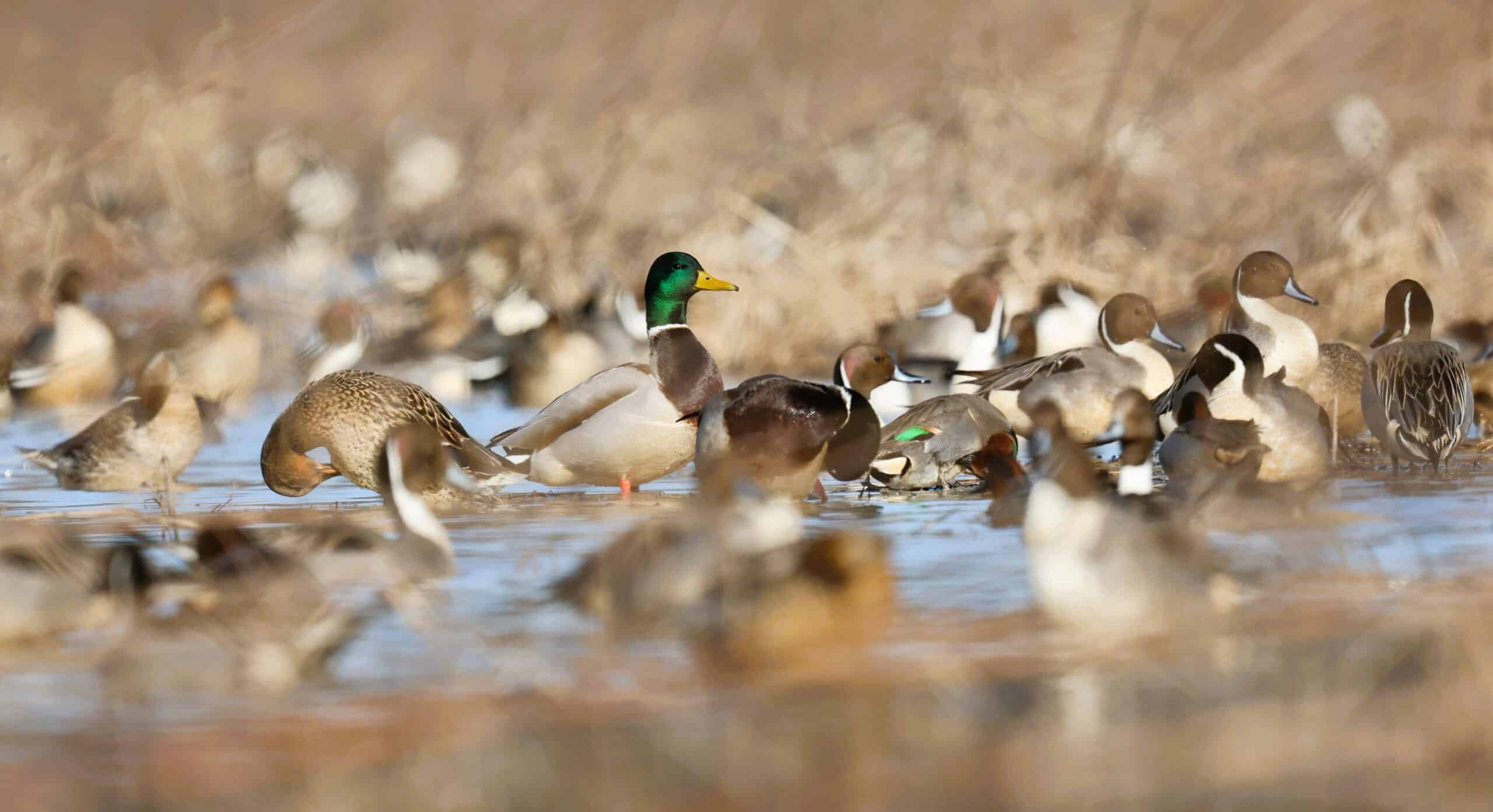
Mallards and pintails find a quiet place to hang out in the Holland Bottoms Waterfowl Rest Area near Jacksonville in this photo from late last year. Photo by Mike Wintroath.
Dec. 6, 2023
Jim Harris
Managing Editor Arkansas Wildlife Magazine
Back in Business
Second Segment of Waterfowl Season Opens Saturday
Waterfowl hunters can return to hunting 30 minutes before sunrise on Saturday, Dec. 9, throughout Arkansas as the state’s 60-day season resumes pretty much like it left off: mostly dry conditions and not a lot of ducks around.
We’re going to learn just how many ducks have been camped out around the state this week in a few days, however, when the Arkansas Game and Fish Commission releases its annual December Waterfowl Aerial Survey of the state. Four AGFC biologists went airborne this week to count ducks (and take note of geese) in the Delta region, the Arkansas River Valley and in southwestern Arkansas. Their data will be studied before AGFC Waterfowl Program Coordinator Brett Leach puts out the results.
Leach said Tuesday that from Monday’s flying by some of the team, “it sounds like there were a couple hot spots but pretty bleak otherwise.” This did not include any flying in the middle and southern portions of the Delta, though, which came later this week. And we can report anecdotally that on the second Saturday of the first second of the season, hunting in southern Arkansas County, it appeared a few large groups of mallards had descended into that portion of the state.
Dry conditions (that is, no snow or ice coverage of food sources) above Arkansas have a lot to do with lack of movement of waterfowl in Arkansas to this point, biologists note. Then, when ducks arrive here, there are not a lot of choice wet areas for the waterfowl to spend their stopover time.
Biologist Alex Zachary, part of the survey team and based in the Arkansas River Valley, flew on Monday and told us the numbers he saw “were marginal at best.”
“Most of the ducks we did see were utilizing more permanent bodies of water such as lakes, reservoirs, stock ponds and oxbows. It’s fairly typical for early in the season and with dry conditions. That being said, we have seen moderate duck use on Ed Gordon (Point Remove WMA). Hunting pressure plays a part in that where they are there one day, gone the next.”
The good news is that the public hunting areas with access to water to flood the moist-soil units and greentree reservoirs are seeing an uptick in water levels. Last Thursday’s heavy rainfall (about 2 inches in Central Arkansas, for example) didn’t hurt. But weather forecasts don’t indicate a lot of rain coming, outside of Saturday.
The second portion of Arkansas’s season will run until sunset Saturday, Dec. 23, before resuming for the final portion on Wednesday, Dec. 27, and concluding Jan. 31.
Ed Gordon Waterfowlers Benefit From Longtime Efforts by AGFC
What had to have stood out to anyone taking note of the habitat conditions and water levels in public hunting areas of Arkansas the first two weekends of the waterfowl season was the water coverage in most of the units of Ed Gordon Point Remove WMA. Having ample hunting water and enough for waterfowl usage can be traced to the infrastructure work that’s been done on Ed Gordon dating to 2014 and a huge project that involved Southwestern Energy and Ducks Unlimited with the AGFC.
“That was a multifaceted project,” Alex Zachary, biologist at Ed Gordon Point Remove WMA, said. “But really the big thing that allowed us to be able to have some water, particularly early this season, was the installation of the new pump station.”
Before the 200-horsepower pump station was built and seven miles of irrigation pipe laid, plus some grading and reshaping of the WMA’s moist-soil units, Ed Gordon Point Remove had five electric relift pumps to put water on the area.
“But how they were designed and where they were set, how they were set, (Point Remove Creek) had to be up and you had to have a good amount of rainfall before they were operational.”
Also, Zachary noted, the pumps were set up to discharge in only one or two locations, “whereas this new pump goes to pretty much every moist-soil impoundment we have, except for two and the waterfowl rest area. But it goes to probably 20 impoundments or close to it.”
The new pump and pipe installation, the brainchild of Buck Jackson, the AGFC’s state wetlands coordinator, was designed to either draw water from Point Remove Creek, or to pull water (that the AGFC would purchase) from the Point Remove Wetlands Reclamation and Irrigation District, which delivers its water through a series of flume ditches from the Arkansas River. The WMA sits mostly within that water district.
But, Zachary said, the AGFC did not have to purchase water for fall flooding this season.
Besides being able to draw water out of the creek and spread it among the units, the WMA benefited from the new pump in irrigating the moist-soil units throughout the summer. That meant more productive moist-soil for the migrating waterfowl (including blue-wing teal in September), helping the moist-soil community’s vegetation and the invertebrates on which waterfowl feed, and wetter soil during the hot and dry summer.
“Beginning with fall flooding, it allowed us to be more efficient with our water usage and allowed us to flood up more quickly because of the soil moisture that was there from irrigation that otherwise wouldn’t have been there at all,” Zachary said.
It’s not a race to flood the units to capacity, Zachary adds. Instead, it’s fine-tuned in a way to stagger flooding through the WMA. Some units will be taken to 30-60 percent of full pool at the beginning of the season, and then that water is moved to another unit. The biologists will come back with more water on each unit as they gradually bring the impoundments to full pool later in the season.
“The goal is twofold in that it spreads more water out over the landscape,” Zachary said. “That allows waterfowl and hunters to spread out and provide more opportunity and … as you stagger the flooding, it’s ensuring that you have new food and resources available for waterfowl going on throughout the wintering period, not just at the beginning.”
Because Ed Gordon had more water than other Arkansas public hunting areas, it had “quite a few folks” for opening weekend, Zachary said. But thanks to a new regulation this year, the WMA will have rest periods during the week: no hunting is allowed Monday, Wednesday and Friday.
Zachary said he noticed one difference at the WMA with the regulation change during the first nine days of the season. “Anecdotally, when we were checking water and pumps during an off day in the first part of the season, we were seeing ducks milling around the area at midmorning, which is not typically what you would have seen in previous years if folks were out hunting,” he said. “This change appears to be reducing disturbance and increasing waterfowl use of the area. We’ll see as the rest of the season continues.”
Always Plan Ahead on Permits
Now we’re in a regular pattern with Arkansas waterfowl hunting. Permits are being offered every weekend until the end of the 60-season. The only odd day out in terms of permits for both the Waterfowl Rice Incentive Conservation Easement program or the WMA permits hunts, whether for youth or adults where permits are required, will be Sunday, Dec. 24. Whereas weekends are usually open, there is no hunting on Christmas Eve; so, that Dec. 23-24 weekend will only have one hunting day available.
The rest of the season has no weekend day off. So jump on those available permits.
Just remember that to obtain a permit, hunters must apply this week to be able to hunt on the weekend of Dec. 16-17 (and on Wednesday at Sheffield Nelson Dagmar WMA’s permitted blinds, which are available to any age hunter that day but to youths on weekends). Application period begins at 3 p.m. Thursday and concludes at midnight Sunday. This includes the WRICE permit application. Winners of permits are notified on Monday.
All applications are $5. Hunters may only apply for one WRICE field per week. Visit the AGFC’s special permit page, which includes more information and a link for WRICE field permit applications and other permit areas, for more information or to apply.
Snow Geese Arrival
Hunters in Arkansas County and sporting goods stores in the area reported to the Waterfowl Report that the number of greater white-front geese seen this year was greater than they had seen in years. (As for the editor of the Waterfowl Report, he can remember when specklebellies were close to nonexistent in these parts, especially after Christmas; not so now). Similar reports passed this way from observers and hunters in Lonoke and Prairie counties as well.
In late October, just as the goose season opened, it was also noted how few snow geese were in the fields compared with specklebellies.
But that all seemed to change at the close of the first season. In the flooded fields on U.S. Highway 165 between Humphrey and Geridge, snow geese were assembled en masse. One of the large flooded fields was a veritable white blanket of geese from one end to the other. This proved true in fields from Stuttgart and on to DeWitt.
Although the AGFC’s aerial surveys of waterfowl have focused on duck counts (because ducks tend to stay in one place even while the planes fly overhead, while geese will scatter), the biologists have been providing some detail to the number of geese seen in recent years. We’ll be interested in seeing what kinds of numbers arise from the transects the biologists have flown this week.
Remember that for the rest of waterfowl season, the hunting of greater white-front geese, snow and blue geese, Ross’s geese and Canada geese follow the same dates as hunting for ducks, mergansers and coots. Hunting for specklebellies will end Jan. 31 along with ducks, mergansers and coots. Snows, blues and Ross’s geese can be hunting into the spring with the Light Goose Conservation Order, which begins Feb. 1.
Check the website for limits of each species during the regular waterfowl season.
- Southwest Arkansas
- Central Arkansas
- East-Central Arkansas
- Northwest Arkansas
- Northeast Arkansas
- Southeast Arkansas
Northeast Arkansas
Big Lake WMA
Map | Water Gauge | Weather Report
When the Ditch 81 extension gauge near Manila (upstream of the Big Lake north-end control structure) reads 17.5 feet, water is beginning to come over the north levee degrade on Big Lake WMA. When the Ditch 81 Extension gauge reads 18.0 feet or higher, the water level on the WMA will rise quickly and hunters should exercise caution while on the area. Be aware of underwater logs in boat runs and hangers in trees.
North Woods GTR
Habitat Type: Mast production
Water Level: Gauge reading at BoDoc is 235.5 feet; target level is 235.5 feet; 80% flooded.
South Woods GTR
Habitat Type: Mast production
Water Level: Gauge reading at 7-Mile is 234.0 feet; target level is 234.5 feet; 80% flooded.
Simmons Field
Habitat: Native vegetation
Water Level: 50% coverage.
Dave Donaldson Black River WMA
Map | Water Gauge | Weather Report
Waterfowl hunters should be aware of hangers and submerged logs within the boat runs and GTRs. Please exercise caution when accessing the area. Please remember to keep boats off the levees so AGFC personnel can access the area. Boats blocking access will be moved. Unattended trailers are not to be left overnight in parking areas. As of Dec. 6, the Black River level at Corning was 1.84 feet and holding.
Upper Island GTR
Habitat Type: Mast crop within the GTRs
Water Level: Current level is 269.55. Target level is 269.5; 100% flooded.
Lower Island GTR
Habitat Type: Mast crop within the GTRs
Water Level: Current level is 268.35 feet msl. Target level is 268.0; 100% flooded.
Upper Reyno GTR
Habitat Type: Mast crop within the GTRs
Water Level: Current level is 266.9 feet msl. Target level is 266.9; 100% flooded.
Lower Reyno GTR
Habitat Type: Mast crop within the GTRs
Water Level: Current level is 266.35 feet msl. Target level is 266.3; 100% flooded.
Winchester GTR
Habitat Type: Mast crop
Water Level: Current level is 263.05 feet msl. Target level is 263.7; 25% flooded.
Earl Buss Bayou DeView WMA
Map | Water Gauge | Weather Report
Boaters should use caution while using the Thompson Tract boat lane.
South Oliver GTR
Habitat Type: Bottomland hardwoods
Water Level: Current gauge reading is 0.0 feet. 0% flooded.
Thompson Tract GTR
Habitat Type: Bottomland hardwoods
Water Level: Current gauge reading is 0.0 feet. 0% flooded. The Thompson Tract GTR will be allowed to rise and fall naturally without the gates being operated later and partially this season. This action is an effort to help the next generation of forest.
Lake Hogue WRA
Habitat Type: Primarily deep open water
Water Level: Normal pool level
Shirey Bay Rainey Brake WMA
Map | Water Gauge | Weather Report
Waterfowl hunters should be aware of hangers and submerged logs within the boat runs and GTRs. Please exercise caution when accessing the area. In addition, hunters should allow safe passage when parking vehicles along roadsides. Vehicles blocking access will be moved.
Adam Brake GTR
Habitat Type: Mast production
Water Level: Water level is 238.1 feet msl with a target level of 240.0 feet msl. 40% flooded.
Rainey Brake GTR
Habitat Type: Mast production
Water Level: 40% flooded.
Eagle Pond GTR
Habitat Type: Mast production
Water Level: 30% flooded.
Phase III Moist-Soil Unit
Habitat Type: Japanese millet.
Water Level: 0% flooded.
Charles Crisp Moist-Soil Unit
Habitat Type: Japanese millet
Water Level: 0% flooded.
Ward Field Moist-Soil Unit
Habitat Type: Native vegetation
Water Level: 80% flooded.
River Field Moist-Soil Unit
Habitat Type: Japanese millet
Water Level: 90% flooded.
St. Francis Sunken Lands WMA
Map | Water Gauge | Weather Report
Hunt Area
Habitat Type: Bottomland hardwoods within the hunt area
Water Level: Water levels on St. Francis Sunken Lands for waterfowl season are dependent on flows from the St. Francis River. The target level for providing huntable timber is 212.0 feet msl at the Oak Donnick gauge. Current reading is 212.67 feet msl.
Snowden WRA
Habitat Type: Mixed grasses
Water Level: 10% flooded
Payneway WRA
Habitat Type: A, B, C and D pools have mixed smartweed and barnyard grasses. Moderate hardwoods within pools A, B and C as well.
Water Level: Pool A is at 0% coverage. Pool B is at 0%. Pool C is at 0%. Pool D is at 10%.
East-Central Arkansas
Henry Gray Hurricane Lake WMA
Map | Water Gauge | Weather Report
Hunters should call the Wildlife Hotline at 800-440-1477 for current road closures.
North Unit
Habitat Type: Bottomland timber
Water Level: The White River at Augusta as of Dec. 4 was 15.96 feet and rising. The water level at Glaise Creek is at 187.79 feet msl and falling. All structures on the North GTR will remain open during the 2023-24 season.
South Unit
Habitat Type: Bottomland timber
Water Level: The White River at Augusta is 15.96 feet and rising as of Dec 4. The water level at Glaise Creek is at 187.79 feet msl and falling. The South Unit now has no structures to close; water will flow freely throughout the unit.
Rex Hancock Black Swamp WMA
Map | Water Gauge | Weather Report
Hunters should call the Wildlife Hotline at 800-440-1477 for current road closures.
Gregory GTR
Habitat Type: Bottomland timber
Water Level: Cache River at Patterson was at 8.37 feet and cresting on Dec 6.
Wiville Moist-Soil Unit
Habitat Type: Native vegetation
Water Level: 90% flooded
Sheffield Nelson Dagmar WMA
Map | Water Gauge | Weather Report
The Conway George units are currently available for hunting by applying for online permits. Youths may apply for Saturday and Sunday hunts, with one adult hunter allowed per one youth, up to four hunters in the blind. Wednesday permit hunts are available for adults (up to four hunters per party, three blinds available). Please visit www.agfc.com for maps, special regulations, permit application and draw dates. Hunters should call the Wildlife Hotline at 800-440-1477 for current road closures. The AGFC will not be putting boards in at Dagmar. Water coverage is dependent on river level.
Mud Slough GTR
Habitat Type: Bottomland timber
Water Level: 25% coverage
Apple Lake WRA (no hunting)
Habitat Type: Bottomland timber
Water Level: 30% coverage.
Conway George Waterfowl Unit A
Habitat Type: Native vegetation
Water Level: 90% coverage
Conway George Waterfowl Unit B
Habitat Type: Natural slough area with beneficial native wetland plants
Water Level: 90% coverage
Conway George Waterfowl Unit C
Habitat Type: Native vegetation
Water Level: 10% coverage
Dark Corner Waterfowl Unit 1
Habitat Type: Native vegetation
Water Level: 5%
Dark Corner Waterfowl Unit 2
Habitat Type: Native vegetation
Water Level: 50%
Dark Corner Waterfowl Unit 3
Habitat Type: Native vegetation
Water Level: No coverage
Steve N. Wilson Raft Creek Bottoms WMA
Map | Water Gauge | Weather Report
Hunting in Raft Creek Bottoms WMA requires participation on the online draw a week before the following weekend’s hunt. There is no online draw on Tuesdays and Thursdays, and permits are available at the boat accesses. Permits ARE required (via online application) on weekends, Tuesdays and Thursdays for the youth and mobility-impaired blinds and for the Magellan Tract. Visit agfc.com to apply for the online draw. There are no designated holes.
The White River gauge at Georgetown on Wednesday, Dec. 6, was 3.37 foot and falling
Unit A
Habitat Type: Native vegetation
Water Level: 100% coverage.
Unit B
Habitat Type: Native vegetation
Water Level: 45%
Unit C
Habitat Type: Native vegetation
Water Level: 25%
Unit D
Habitat Type: Native vegetation
Water Level: 70%
Unit E
Habitat Type: Native vegetation
Water Level: 80%
Unit F (Youth Area)
Habitat Type: Native vegetation
Water Level: 100%
Unit G
Habitat Type: Native vegetation.
Water Level: 0%
Unit H (Mobility-impaired blind)
Habitat Type: Native vegetation
Water Level: 100%
Unit I
Habitat Type: Native vegetation.
Water Level: 0%
Unit J (Cypert Tract)
Habitat Type: Native vegetation
Water Level: 75%
Unit K (Cypert Tract)
Habitat Type: Native vegetation
Water Level: 5%
Unit L (Cypert Tract)
Habitat Type: Native vegetation
Water Level: 0%
Unit M (Magellan Tract)
Habitat Type: Native vegetation
Water Level: 95%
Central Arkansas
Bell Slough WMA
Map | Weather Report
Bell Slough GTR
Flooding of the Bell Slough GTR is rainfall dependent. Gates were lowered in the GTR water control structure Nov. 17.
Habitat Type: Bottomland hardwood/cypress-tupelo
Water Level: 0%
Palarm Creek WRA
Habitat Type: Native moist-soil vegetation
Water Level: 65%
Craig D. Campbell Lake Conway Reservoir
Map | Weather Report
Due to planned renovation work to Craig D. Campbell Lake Conway Reservoir, water levels are currently 4-4.5 feet below normal pool on both Pierce and Dix creeks.
Cypress Bayou WMA
Map| Weather Report
Hunt Area
Habitat Type: Good mast crop
Water Level: 0% coverage.
Red Cut Slough Tract
Unit 1
Habitat Type: Native vegetation
Water Level: 5%
Unit 2
Habitat Type: Native vegetation
Water Level: 0%
Unit 3
Habitat Type: Native vegetation
Water Level: 5%
Unit 4
Habitat Type: Native vegetation
Water Level: 40%
Unit 5
Habitat Type: Native vegetation.
Water Level: 70%
Unit 6
Habitat Type: Open water reservoir
Water Level: 65%
Harris Brake WMA
Map | Weather Report
Upper GTR
Habitat Type: Good mast crop
Water Level: 100% coverage
Lower GTR
Habitat Type: Good mast crop.
Water Level: 15% coverage. The Harris Brake Lake valve was opened on Nov. 15 to begin supplemental flooding of both the Lower and Upper GTRs. Damage to one of the Lower GTRs water control structures is allowing water to drain from the Lower GTR and can’t currently be fixed. Sloughs and ditches within the Lower GTR unit will continue to hold water. However, the majority of the Lower GTR unit will stay drained due to the water control structure damage.
Holland Bottoms WMA
Map | Weather Report
Hunt Area
Habitat Type: Mast crop
Water Level: Most of the low lying areas scattered around the WMA have a few inches of water or are completely dry.
Lake Pickthorne WRA (no hunting)
Habitat Type: Native vegetation and millet
Water Level: The East Unit is at 0%, and the West Unit 40% flooded.
Northwest Arkansas
Dardanelle WMA
Map | Weather Report
McKennon Bottoms (half-day hunting)
Habitat Type: Native moist soil
Water Level: 100% coverage
Potter’s Pothole Hartman Waterfowl Unit (half-day hunting)
Habitat Type: Japanese millet and native moist-soil vegetation
Water Level: 100% coverage
Ed Gordon Point Remove WMA
Map | Weather Report
Flooding of waterfowl impoundments on Ed Gordon Point Remove WMA began Oct. 27 and will continue as long as water levels in Point Remove Creek allow.
Little Hole (Unit 1)
Habitat Type: Native moist-soil vegetation
Water Level: 70% flooded
Willow Island (Unit 2)
Habitat Type: Native moist-soil vegetation
Water Level: 90%
Red Gate (Unit 3)
Habitat Type: Native moist-soil vegetation
Water Level: 95%
Pig Trough (Units 4 and 5)
Habitat Type: Native moist-soil vegetation and Japanese millet
Water Level: 75%
Cedar Ridge (Unit 6)
Habitat Type: Native moist-soil vegetation
Water Level: 75%
Unit 7a
Habitat Type: Native moist-soil vegetation
Water Level: 80%
Unit 7b
Habitat Type: Native moist-soil vegetation
Water Level: 0%
Duck Trap (Units 8a, 8b and 8c)
Habitat Type: Native moist-soil vegetation
Water Level: 65%
8b
Habitat Type: Native moist-soil vegetation
Water Level: 50%
8c
Habitat Type: Native moist-soil vegetation
Water Level: 50%
Unit 9
Habitat Type: Native moist-soil vegetation
Water Level: 60%
Controversy Corner (Unit 10)
Habitat Type: Native moist-soil vegetation and Japanese millet
Water Level: 80%
Remmel Marsh
Habitat Type: Native moist-soil vegetation
Water Level: 90%
Mud Pond (Unit 12)
Habitat Type: Native moist-soil vegetation
Water Level: 50%
Turkey Pond (Units 13a, 13b and 13c)
13a
Habitat Type: Native moist-soil vegetation
Water Level: 75%
13b
Habitat Type: Native moist-soil vegetation
Water Level: 0%
13c
Habitat Type: Native moist-soil vegetation
Water Level: 80%
Teeny Pond (Unit 14)
Habitat Type: Native moist-soil vegetation
Water Level: 20%
Salt Lick (Unit 15)
Habitat Type: Native moist-soil vegetation
Water Level: 60%
Bobby’s Pond (Unit 16)
Habitat Type: Native moist-soil vegetation
Water Level: 60%
Race Track (Unit 17)
Habitat Type: Native moist-soil vegetation
Water Level: 70%
Frog Bayou WMA
Map | Weather Report
Unit 1
Habitat Type: Japanese millet and moist soil vegetation
Water Level: 25% coverage. Pumping began Dec. 4.
Unit 2
Habitat Type: Native moist soil vegetation. Unit is rainfall dependent.
Water Level: 75%.
Unit 3
Habitat Type: Native moist soil vegetation
Water Level: 75%. Pumping began Nov. 27.
Unit 4
Habitat Type: Native moist soil vegetation
Water Level: 100%
Unit 5
Habitat Type: Native moist soil vegetation
Water Level: 100%
Unit 6
Habitat Type: Native moist soil vegetation
Water Level: 25%. Pumping began Dec. 4.
Unit 7
Habitat Type: Japanese millet and Native moist soil vegetation
Water Level: 100%
Galla Creek WMA
Map | Weather Report
Galla Creek
Habitat Type: Native moist soil vegetation and Japanese millet. Staged flooding of the waterfowl impoundment began Nov. 7, and the gate was raised again Dec. 1 to initiate the second stage of flooding. The gate will be raised to begin the final stage of flooding on Jan. 4.
Water Level: 70%
Nimrod Lloyd Millwood WMA
Map | Weather Report
Nimrod GTR
Habitat Type: The red oak mast crop is moderate this year as well as the desirable native vegetation growth. The water control structures were closed on Nov. 15.
Water Level: 5% flooded. Flooding of the area is rainfall dependent.
Ozark Lake WMA/Dyer Lake Water Unit
Weather Report
Dyer Lake Cells
Unit 1 Dyer main cell
Habitat Type: Japanese millet
Water Level: 100% coverage for both units
Unit 2 Dyer Road Cell
Habitat Type: Native moist soil
Water Level: 100% coverage
Unit 3 South Cell
Habitat Type: Chiwapa and Japanese millet
Water Level: 25% coverage
Unit 4 West Cell (rainfall dependent)
Habitat Type: Fallow disked
Water Level: 0% coverage
Petit Jean River WMA
Map | Water Gauge | Weather Report
Sorehead Moist-Soil Unit
Habitat Type: Native vegetation
Water Level: 100%
Blacklands Moist-Soil Unit
Habitat Type: Native vegetation. The red oak trees within the unit produced a moderate mast crop this year. Pumping of this unit is dictated by river levels. Due to the constant river level fluctuations, there is not a set date that this unit will be at full pool.
Water Level: 80%
Slaty Crossing Moist-Soil Unit
Habitat Type: Native vegetation
Water Level: 90%
Blacklands Duck Area
Habitat Type: Native vegetation
Water Level: 100%
Pullen Pond Marsh
Habitat Type: Native vegetation
Water Level: 10%. Flooding of the area is rainfall dependent.
Pond Creek GTR
Habitat Type: The red oak mast crop is moderate this year as well as the desirable native vegetation growth. The water control structures were closed Nov. 15.
Water Level: 10%. Flooding of this area is rainfall dependent.
Slaty GTR
Habitat Type: The red oak mast crop is moderate this year as well as the desirable native vegetation growth. The water control structures were closed Nov. 15.
Water Level: 10%. Flooding of this area is rainfall dependent.
Santa Fe GTR
Habitat Type: The red oak mast crop is moderate this year as well as the desirable native vegetation growth. The water control structures were closed Nov. 15.
Water Level: 5%. Flooding of this area is rainfall dependent.
Southwest Arkansas
Dr. Lester Sitzes III Bois d’Arc WMA
Map | Weather Report
Bois d’Arc Lake WRA
Habitat Type: Closed to hunting.
Water Level: Normal
Red Slough WRA
Habitat Type: Closed to hunting.
Water Level: 75% coverage
GTR
Habitat Type: Bottomland timber
Water Level: 85%
Little Grassy
Habitat Type: Native moist-soil vegetation
Water Level: 65%
Millwood Lake
Map | Water Gauge | Weather Report
Habitat Type: Natural vegetation
Water Level: Millwood is at 261.23 feet msl, 2 feet above normal conservation pool, as of Dec. 6.
Ozan WMA
Map | Weather Report
Flooding of all units is rainfall dependent.
Unit 1
Habitat Type: Native moist soil vegetation
Water Level: 70%
Unit 2
Habitat Type: Native moist-soil vegetation
Water Level: 40%
Unit 3
Habitat Type: Native moist-soil vegetation
Water Level: 30%
Unit 4
Habitat Type: Native moist-soil vegetation
Water Level: 50%
Unit 5
Habitat Type: Native moist-soil vegetation
Water Level: 20%
Sulphur River WMA
Map | Weather Report
Mercer Bayou
Habitat Type: Natural vegetation
Water Level: 100%
Henry Moore WRA
Habitat Type: Closed to hunting.
Water Level: 30%
Southeast Arkansas
Beryl Anthony Lower Ouachita WMA
Map | Weather Report
Water Level: No water
Cut-Off Creek WMA
Map | Weather Report
Hunt Area
Habitat Type: Bottomland hardwood habitat
Water Level: No water
Pigeon Creek WRA
Habitat Type: Bottomland hardwood habitat
Water Level: No water
Freddie Black Choctaw Island WMA Deer Research Area
Map | Water Gauge | Weather Report
Habitat Type: Bottomland hardwood habitat
Water Level: Flooding is river dependent. Click on the Water Gauge link above for current Mississippi River levels. Use extreme caution when boating in the river.
The Freddie Black Choctaw Island WMA West Unit allows weekend permit hunting for youths (one adult per youth hunter); on Wednesdays, all ages may apply for a permit to hunt the blinds in the West Unit.
George H. Dunklin Jr. Bayou Meto WMA
Map | Water Gauge | Weather Report
The UGSG is reporting real-time water gauge readings at the headwater at each GTR within the George H. Dunklin Bayou Meto WMA. Click the Water Gauge link above for the WMA, and search for the particular GTR as noted.
NOTE: During the 2023-24 wintering period, all intentional flooding will be held at 178.5 feet msl, an elevation that will relieve stress on many trees such as red oaks that are showing signs of distress. Rain and increased flow into the WMA will allow water to rise above that level periodically. A good rule of thumb for comparing water levels to access into Bayou Meto: 176 feet msl – water breaking into sloughs and lower ditches; 177-177.5 feet msl – water beginning to break out of sloughs and lower ditches; 178 feet msl – water in most sloughs and ditches and entering into lower elevations in woods; 178.5 feet msl – most ditches and sloughs deep enough to boat and most boat ramps become serviceable; 179 feet msl or above – water expands to the higher elevations.
Upper Vallier GTR
Habitat Type: Bottomland hardwood habitat
Water Level: 175.53 feet msl and rising as of Dec. 6. See Gauge Link (Upper Vallier Headwater) for updated info.
Lower Vallier GTR
Habitat Type: Bottomland hardwood habitat
Water Level: 177.41 feet msl and rising as of Dec. 6. See Gauge Link (Lower Vallier Headwater) for updated info.
Government Cypress GTR
Habitat Type: Bottomland hardwood habitat
Water Level: 177.69 feet msl and rising as of Dec. 6. See Gauge Link (Government Cypress Headwater) for updated info.
Buckingham Flats GTR
Habitat Type: Bottomland hardwood habitat
Water Level: 175.55 feet and falling as of Dec. 6. See Gauge Link (Buckingham Flats Headwater) for updated info.
Temple Island GTR
Habitat Type: Bottomland hardwood habitat
Water Level: 177.34 feet msl as of Dec. 6. See Gauge Link (Temple Island Headwater) for updated info. Water too low for pumping.
Canon Brake
Habitat Type: Bottomland hardwood
Water Level: 163.76 feet msl as of Dec. 6. See Gauge Link (Canon Brake Headwater) for updated info.
Halowell WRA
Habitat Type: Moist soil
Water Level: Staggered flooding of units
Wrape Plantation WRA
Habitat Type: Moist soil
Water Level: Staggered flooding of units
Seven Devils WMA
Map | Weather Report
Hunt Area
Habitat Type: Bottomland hardwood habitat
Water Level: No water
Trusten Holder WMA
Map | Water Gauge | Weather Report
Habitat Type: Bottomland hardwood habitat
Water Level: Flooding is river dependent. Click on the Water Gauge link above for current Arkansas River levels.
Recent News
Subscribe to Our Weekly Newsletter E-mails
Don’t miss another issue. Sign up now to receive the AGFC Wildlife Weekly Newsletter in your mailbox every Wednesday afternoon (Waterfowl Reports are published weekly during waterfowl season and periodically outside the season). Fishing Reports arrive on Thursdays. Fill in the following fields and hit submit. Thanks, and welcome!