Arkansas Wildlife Weekly Waterfowl Report
BY Jim Harris
ON 11-22-2023
Nov. 22, 2023
Jim Harris
Managing Editor Arkansas Wildlife Magazine
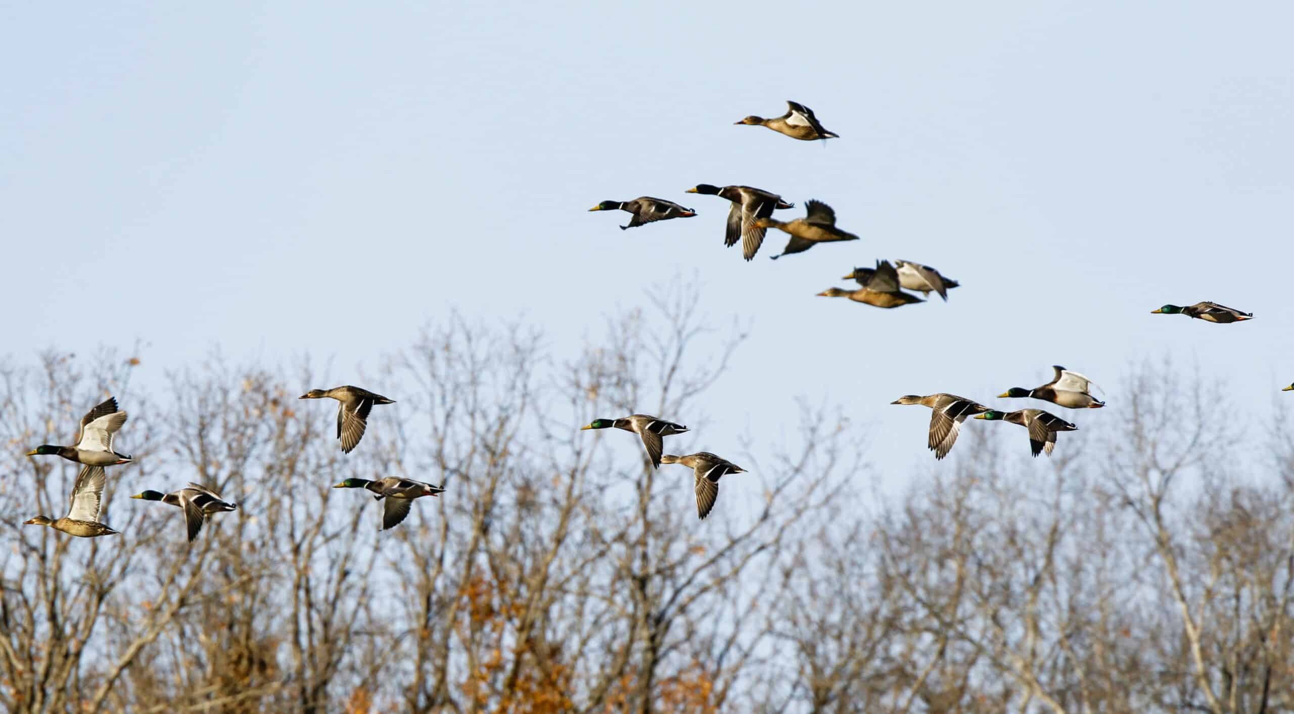
Waterfowl Season Moves Into Second Weekend
Arkansas’s first segment of its 60-day waterfowl season runs for nine days, and by sunset on Sunday, Nov. 26, the hunting will be done. With the exception of one day allocated for the Special Youth Hunt on Saturday, Dec. 2, the waterfowl in Arkansas will get a 12-day respite from hunters.
From anecdotal hunter reports and in-person experiences by AGFC staff, the first weekend of waterfowl hunting in The Natural State produced spotty results. If enough water and food sources were nearby, hunters reported fair to good success. Many hunters also noted success in east-central and south-central Arkansas with goose hunting (primarily greater white-fronted geese) over their duck hunting efforts, or at least on an even basis. Employees at Webb Sporting Goods in DeWitt say this has been the best year for specklebelly hunting in the southern portion of Arkansas County that they can remember.
Others related, however, that areas where they were used to annually finding success chasing ducks proved fruitless on the opening weekend.
The culprit for many who were hoping for a big opening day last Saturday was likely the dry conditions throughout much of the state. Many acres of public lands usually available for waterfowl hunting were without much needed moisture, and ducks avoided them. George H. Dunklin Bayou Meto WMA and Steve N. Wilson Raft Creek Bottoms WMA, two of the more popular destinations year-in and year-out for waterfowl hunters in Arkansas, had little or no water.
Temperatures also were mild last weekend, and conditions to the north of Arkansas aren’t much different.
The state did see some rainfall Monday, some of it heavy in spots, and a few areas that were reported dry a week ago in the AGFC’s Weekly Waterfowl Report showed an uptick in water, albeit slight in cases.
WRICE Picking Up
This week, 38 fields in the AGFC’s Waterfowl Rice Incentive Conservation Enhancement program were available for permits, allowing public-permitted hunts on private rice fields around the state. This was one more field than was available on opening weekend. As many as 40 other fields contracted with the program this year have had no nearby water source to pump the fields before the first two weeks of the season, which also points to the lack of rainfall seen around the state through late summer and into fall.
By next weekend, though, another 16 fields are expected to have enough water to be huntable — based on what is available in the permit application period this week — and all youths under 16 who plan to hunt on the Special Youth Hunt on Dec. 2 are eligible to apply for a permit to a WRICE field, as well as apply for permits for youth blinds at Steve N. Wilson Raft Creek Bottoms WMA and Sheffield Nelson Dagmar WMA Conway George Tract blinds. Youths do not need a permit to hunt Raft Creek Bottoms WMA in other places besides the youth blind, and they may also hunt all off Red Cut Slough in Cypress Bayou WMA. Go to https://www.agfc.com/hunting/waterfowl/special-waterfowl-permit-hunts/ for more information or to apply.
The second segment of Arkansas’s duck season will start up 30 minutes before sunrise Saturday, Dec. 9, and run through Saturday, Dec. 23. There is a three-day break between segments around Christmas Eve and Christmas Day before the season resumes for its third and last segment Dec. 27-Jan. 31.
Remember: For all hunters wanting to apply for a WRICE permit for the resumption of the season and the weekend of Dec. 9-10, you will begin applying at 3 p.m. Thursday, Nov. 30 (through midnight Sunday, Dec. 3).
New This Year
As more water is sure to arrive in Arkansas via Mother Nature and as boating becomes easier, waterfowlers using public land should note some regulation changes this year compared with seasons past:
* Hunting on Bell Slough, Ed Gordon Point Remove and Galla Creek WMAs and the Dyer Lake Unit of Ozark Lake WMA is limited Saturdays, Sundays, Tuesdays and Thursdays and the last day of regular duck season. No permits are required at these locales, but it’s important to note that there is no hunting Mondays, Wednesdays and Fridays (with the exception of Wednesday, Jan. 31).
* Many of the AGFC’s WMAs will require boats this year to have motors with ONLY FACTORY EXHAUST SYSTEMS INSTALLED. These WMAs are: Bell Slough, Beryl Anthony Lower Ouachita, Big Lake, Camp Robinson, Cut-Off Creek, Cypress Bayou, Dave Donaldson Black River, Dr. Lester Sitzes III Bois d’Arc, Earl Buss Bayou DeView, Ed Gordon Point Remove, Galla Creek, George H. Dunklin Bayou Meto, Harris Brake, Henry Gray Hurricane Lake, Petit Jean River, Rex Hancock Black Swamp, Seven Devils, Steve N. Wilson Raft Creek Bottoms, Sheffield Nelson Dagmar, Shirey Bay Rainey Brake and Sulphur River. Also, Cache River, Dale Bumpers White River, FelsenThal and Overflow national wildlife refuges have the same regulation.
* Confusion for boaters on the Cache River has been alleviated with a regulation change allowing unrestricted boating on a portion of the river that runs through or is adjacent to Rex Hancock Black Swamp WMA. Because of the 4 a.m. rule on entering WMAs, hunters were not sure if they could boat the Cache River through the WMA outside of the hours allowed for WMA use during waterfowl season.
Also, nonresidents who are hunting in Arkansas this waterfowl season should note:
* A 30-day Nonresident WMA Waterfowl Permit ($200) was approved for this season by the Arkansas Game and Fish Commissioners in October, allowing for hunting on the days allowed for nonresident public hunting. The way the season fell this year, including with the nine-day first segment, nonresidents would have had to purchase seven $40 5-day permits to cover the 30 days available for nonresident hunting on public land.
* Also, nonresidents need to be aware of other new requirements and fees that were set during the offseason. These changes can be viewed on the website (agfc.com) or in the 2023-24 Waterfowl Hunting Guidebook, which can be found under “Regulations” on the agency’s newly revamped website, www.agfc.com.
- Southwest Arkansas
- Central Arkansas
- East-Central Arkansas
- Northwest Arkansas
- Northeast Arkansas
- Southeast Arkansas
Northeast Arkansas
Big Lake WMA
Map | Water Gauge | Weather Report
When the Ditch 81 extension gauge near Manila (upstream of the Big Lake north-end control structure) reads 17.5 feet, water is beginning to come over the north levee degrade on Big Lake WMA. When the Ditch 81 Extension gauge reads 18.0 feet or higher, the water level on the WMA will rise quickly and hunters should exercise caution while on the area. Be aware of underwater logs in boat runs and hangers in trees.
North Woods GTR
Habitat Type: Mast production
Water Level: Gauge reading at BoDoc is 234.2 feet; target level is 235.5 feet; 0% flooded.
South Woods GTR
Habitat Type: Mast production
Water Level: Gauge reading at 7-Mile is 233.2 feet; target level is 234.5 feet; 50% flooded.
Simmons Field
Habitat: Native production is good in the north middle and south fields.
Water Level: 0% coverage.
Dave Donaldson Black River WMA
Map | Water Gauge | Weather Report
Waterfowl hunters should be aware of hangers and submerged logs within the boat runs and GTRs. Please exercise caution when accessing the area. Please remember to keep boats off the levees so AGFC personnel can access the area. Boats blocking access will be moved. Unattended trailers are not to be left overnight in parking areas. As of Nov. 13, the current Black River level is 1.75 feet and holding.
Upper Island GTR
Habitat Type: Mast crop within the GTRs
Water Level: Current level is 269.45. Target level is 269.5; 95% flooded.
Lower Island GTR
Habitat Type: Mast crop within the GTRs
Water Level: Current level is below readable gauge level. Target level is 268.0; 50% flooded.
Upper Reyno GTR
Habitat Type: Mast crop within the GTRs
Water Level: Current level is 266.1 feet msl. Target level is 266.9; 30% flooded.
Lower Reyno GTR
Habitat Type: Mast crop within the GTRs
Water Level: Current level is 265.55 feet msl. Target level is 266.3; 15% flooded.
Winchester GTR
Habitat Type: Mast crop
Water Level: Current level is below readable gauge level. Target level is 263.7; 5% flooded.
Earl Buss Bayou DeView WMA
Map | Water Gauge | Weather Report
Boaters should use caution while using the Thompson Tract boat lane.
South Oliver GTR
Habitat Type: Bottomland hardwoods
Water Level: Current gauge reading is 0.0 feet 0% flooded.
Thompson Tract GTR
Habitat Type: Bottomland hardwoods
Water Level: Current gauge reading is 0.0 feet. 0% flooded. The Thompson Tract GTR will be allowed to rise and fall naturally without the gates being operated later and partially this season. This action is an effort to help the next generation of forest.
Lake Hogue WRA
Habitat Type: Primarily deep open water
Water Level: Normal pool level
Shirey Bay Rainey Brake WMA
Map | Water Gauge | Weather Report
Waterfowl hunters should be aware of hangers and submerged logs within the boat runs and GTRs. Please exercise caution when accessing the area. In addition, hunters should allow safe passage when parking vehicles along roadsides. Vehicles blocking access will be moved.
Adam Brake GTR
Habitat Type: Mast production
Water Level: Water level is 237.8 feet with a target level of 240.0 feet msl. 30% flooded.
Rainey Brake GTR
Habitat Type: Mast production
Water Level: 15% flooded.
Eagle Pond GTR
Habitat Type: Mast production
Water Level: 0% flooded.
Phase III Moist-Soil Unit
Habitat Type: Japanese millet.
Water Level: 0% flooded.
Charles Crisp Moist-Soil Unit
Habitat Type: Japanese millet
Water Level: 0% flooded.
Ward Field Moist-Soil Unit
Habitat Type: Barnyard and panicum grass composition
Water Level: 0% flooded.
River Field Moist-Soil Unit
Habitat Type: Japanese millet
Water Level: 70% flooded.
St. Francis Sunken Lands WMA
Map | Water Gauge | Weather Report
Hunt Area
Habitat Type: Bottomland hardwoods within the hunt area.
Water Level: Water levels on St. Francis Sunken Lands for waterfowl season are dependent on flows from the St. Francis River. The target level for providing huntable timber is 212.0 feet msl at the Oak Donnick gauge. Current reading is 211.74 feet msl.
Snowden WRA
Habitat Type: Mixed grasses
Water Level: 10% flooded
Payneway WRA
Habitat Type: A, B, C and D pools have mixed smartweed and barnyard grasses. Moderate hardwoods within pools A, B and C as well.
Water Level: Pool A is at 0 coverage. Pool B is at 0%. Pool C is at 0%. Pool D is at 10%.
East-Central Arkansas
Henry Gray Hurricane Lake WMA
Map | Water Gauge | Weather Report
Hunters should call the Wildlife Hotline at 800-440-1477 for current road closures.
North Unit
Habitat Type: Bottomland timber
Water Level: The White River at Augusta as of Nov. 20 was 13.08 feet and rising. The water level at Glaise Creek is at 187.02 feet msl. All structures on the North GTR will remain open during the 2023-24 season.
South Unit
Habitat Type: Bottomland timber
Water Level: The White River at Augusta is 13.08 feet. The water level at Glaise Creek is at 187.02 feet msl. There are no structures to close on the South Unit.
Rex Hancock Black Swamp WMA
Map | Water Gauge | Weather Report
Hunters should call the Wildlife Hotline at 800-440-1477 for current road closures.
Gregory GTR
Habitat Type: Bottomland timber
Water Level: Cache River at Patterson was at 3.48 feet and stable on Nov. 20.
Wiville Moist-Soil Unit
Habitat Type: Native vegetation
Water Level: 15% flooded
Sheffield Nelson Dagmar WMA
Map | Water Gauge | Weather Report
The Conway George units are currently available for hunting by applying for online permits. Youths may apply for Saturday and Sunday hunts, with one adult hunter allowed per one youth, up to four hunters in the blind. Wednesday permit hunts are available for adults (up to four hunters per party, three blinds available). Please visit www.agfc.com for maps, special regulations, permit application and draw dates. Hunters should call the Wildlife Hotline at 800-440-1477 for current road closures. The AGFC will not be putting boards in at Dagmar. Water coverage is dependent on river level.
Mud Slough GTR
Habitat Type: Bottomland timber
Water Level: 15% coverage
Apple Lake WRA (no hunting)
Habitat Type: Bottomland timber
Water Level: 25% coverage.
Conway George Waterfowl Unit A
Habitat Type: Native vegetation
Water Level: 90% coverage
Conway George Waterfowl Unit B
Habitat Type: Natural slough area with beneficial native wetland plants
Water Level: 90% coverage
Conway George Waterfowl Unit C
Habitat Type: Native vegetation
Water Level: 0% coverage
Dark Corner Waterfowl Unit 1
Habitat Type: Native vegetation
Water Level: No coverage
Dark Corner Waterfowl Unit 2
Habitat Type: Native vegetation
Water Level: No coverage
Dark Corner Waterfowl Unit 3
Habitat Type: Native vegetation
Water Level: No coverage
Steve N. Wilson Raft Creek Bottoms WMA
Hunting in Raft Creek Bottoms WMA requires participation on the online draw a week before the following weekend’s hunt. There is no online draw on Tuesdays and Thursdays, and permits are available at the boat accesses. Permits ARE required (via online application) on weekends, Tuesdays and Thursdays for the youth and mobility-impaired blinds and for the Magellan Tract. Visit agfc.com to apply for the online draw. There will be no designated holes this season.
The White River gauge at Georgetown on Monday, Nov. 20 was 1 foot and stable.
Map | Water Gauge | Weather Report
Unit A
Habitat Type: Native vegetation
Water Level: 60% coverage.
Unit B
Habitat Type: Native vegetation
Water Level: 20%
Unit C
Habitat Type: Native vegetation
Water Level: 15%
Unit D
Habitat Type: Native vegetation
Water Level: 25%
Unit E
Habitat Type: Native vegetation
Water Level: 25%
Unit F (Youth Area)
Habitat Type: Native vegetation
Water Level: 100%
Unit G
Habitat Type: Habitat conditions are poor.
Water Level: 0%
Unit H (Mobility-impaired blind)
Habitat Type: Native vegetation
Water Level: 100%
Unit I
Habitat Type: Conditions are poor.
Water Level: 0%
Unit J (Cypert Tract)
Habitat Type: Native vegetation
Water Level: 50%
Unit K (Cypert Tract)
Habitat Type: Native vegetation
Water Level: 5%
Unit L (Cypert Tract)
Habitat Type: Native vegetation
Water Level: 0%
Unit M (Magellan Tract)
Habitat Type: Native vegetation
Water Level: 5%
Central Arkansas
Bell Slough WMA
Bell Slough GTR: Flooding of the Bell Slough GTR is rainfall dependent. Gates were lowered in the GTR water control structure on Nov. 17.
Habitat Type: Bottomland hardwood/cypress-tupelo
Water Level: 0%
Palarm Creek WRA
Habitat Type: Native moist-soil vegetation
Water Level: 65%
Craig D. Campbell Lake Conway Reservoir
Due to planned renovation work to Craig D. Campbell Lake Conway Reservoir, water levels are currently 3.5-4 feet below normal pool on both Pierce and Dix creeks.
Cypress Bayou WMA
Hunt Area
Habitat Type: Good mast crop
Water Level: 0% coverage.
Red Cut Slough Tract
Unit 1
Habitat Type: Habitat conditions are good
Water Level: 5%
Unit 2
Habitat Type: NA
Water Level: 5%
Unit 3
Habitat Type: Native vegetation
Water Level: 5%
Unit 4
Habitat Type: Native vegetation
Water Level: 15%
Unit 5
Habitat Type: Native vegetation.
Water Level: 70%
Unit 6
Habitat Type: NA
Water Level: 65%
Harris Brake WMA
Upper GTR
Habitat Type: Good mast crop
Water Level: 60% coverage
Lower GTR
Habitat Type: Good mast crop.
Water Level: 15% coverage. The Harris Brake Lake valve was opened on Nov. 15 to begin supplemental flooding of both the Lower and Upper GTRs.
Holland Bottoms WMA
Hunt Area
Habitat Type: Mast crop
Water Level: Most of the low lying areas scattered on the WMA are completely dry.
Lake Pickthorne WRA (no hunting)
Habitat Type: Native vegetation and millet
Water Level: The East Unit is at 0%, and the West Unit 0% flooded.
Northwest Arkansas
Dardanelle WMA
McKennon Bottoms (half-day hunting)
Habitat Type: Native moist soil
Water Level: 100% coverage
Potter’s Pothole Hartman Waterfowl Unit (half-day hunting)
Habitat Type: Japanese millet and native moist-soil vegetation
Water Level: 100% coverage
Ed Gordon Point Remove WMA
Flooding of waterfowl impoundments on Ed Gordon Point Remove WMA began Oct. 27 and will continue as long as water levels in Point Remove Creek allow.
Little Hole (Unit 1)
Habitat Type: Native moist-soil vegetation
Water Level: 70% flooded
Willow Island (Unit 2)
Habitat Type: Native moist-soil vegetation
Water Level: 10%
Red Gate (Unit 3)
Habitat Type: Native moist-soil vegetation
Water Level: 70%
Pig Trough (Units 4 and 5)
Habitat Type: Native moist-soil vegetation and Japanese millet
Water Level: 60%
Cedar Ridge (Unit 6)
Habitat Type: Native moist-soil vegetation
Water Level: 70%
Unit 7a
Habitat Type: Native moist-soil vegetation
Water Level: 70%
Unit 7b
Habitat Type: Native moist-soil vegetation
Water Level: 0%
Duck Trap (Units 8a, 8b and 8c)
Habitat Type: Native moist-soil vegetation
Water Level: 65%
8b
Habitat Type: Native moist-soil vegetation
Water Level: 50%
8c
Habitat Type: Native moist-soil vegetation
Water Level: 50%
Unit 9
Habitat Type: Native moist-soil vegetation
Water Level: 60%
Controversy Corner (Unit 10)
Habitat Type: Native moist-soil vegetation and Japanese millet
Water Level: 70%
Remmel Marsh
Habitat Type: Native moist-soil vegetation
Water Level: 70%
Mud Pond (Unit 12)
Habitat Type: Native moist-soil vegetation
Water Level: 50%
Turkey Pond (Units 13a, 13b and 13c)
13a
Habitat Type: Native moist-soil vegetation
Water Level: 60%
13b
Habitat Type: Native moist-soil vegetation
Water Level: 0%
13c
Habitat Type: Native moist-soil vegetation
Water Level: 0%
Teeny Pond (Unit 14)
Habitat Type: Native moist-soil vegetation
Water Level: 0%
Salt Lick (Unit 15)
Habitat Type: Native moist-soil vegetation
Water Level: 60%
Bobby’s Pond (Unit 16)
Habitat Type: Native moist-soil vegetation
Water Level: 60%
Race Track (Unit 17)
Habitat Type: Native moist-soil vegetation
Water Level: 70%
Frog Bayou WMA
Unit 1
Habitat Type: Japanese millet and moist soil vegetation
Water Level: 0% coverage. Pumping scheduled to begin Dec. 4.
Unit 2
Habitat Type: Native moist soil vegetation. Unit is rainfall dependent.
Water Level: 25%. Boards were put in Nov. 13.
Unit 3
Habitat Type: Native moist soil vegetation
Water Level: 10%. Pumping scheduled to begin Nov. 27.
Unit 4
Habitat Type: Native moist soil vegetation
Water Level: 100%
Unit 5
Habitat Type: Native moist soil vegetation
Water Level: 25%. Pumping scheduled to begin Dec. 4.
Unit 6
Habitat Type: Native moist soil vegetation
Water Level: 0%. Pumping scheduled to begin Dec. 4.
Unit 7
Habitat Type: Japanese millet and Native moist soil vegetation
Water Level: 0%. Pumping scheduled to begin Nov. 29.
Galla Creek WMA
Galla Creek
Habitat Type: Native moist soil vegetation and Japanese millet. Staged flooding of the waterfowl impoundment began Nov. 7 and will continue throughout waterfowl season with gate next being raised to begin the second stage of flooding on Dec. 1.
Water Level: 30%
Nimrod Lloyd Millwood WMA
Nimrod GTR
Habitat Type: The red oak mast crop is moderate this year as well as the desirable native vegetation growth. The water control structures were closed on Nov. 15.
Water Level: 2% flooded. Flooding of the area is rainfall dependent.
Ozark Lake WMA/Dyer Lake Water Unit
Dyer Lake Cells
Unit 1 Dyer main cell
Habitat Type: Japanese millet
Water Level: 100% coverage for both units
Unit 2 Dyer Road Cell
Habitat Type: Native moist soil
Water Level: 100% coverage
Unit 3 South Cell
Habitat Type: Chiwapa and Japanese millet
Water Level: 5% coverage
Unit 4 West Cell (rainfall dependent)
Habitat Type: Fallow disked
Water Level: 0% coverage
Petit Jean River WMA
Map | Water Gauge | Weather Report
Sorehead Moist-Soil Unit
Habitat Type: This unit was able to grow a stand of desirable native vegetation this year.
Water Level: 100%
Blacklands Moist-Soil Unit
Habitat Type: This summer the units produced a stand of desirable native vegetation. The red oak trees within the unit produced a moderate mast crop this year. Pumping of this unit is dictated by river levels. Due to the constant river level fluctuations, there is not a set date that this unit will be at full pool.
Water Level: 30%.
Slaty Crossing Moist-Soil Unit
Habitat Type: Due to ongoing waterfowl habitat enhancement projects, this unit was not able to grow a desirable native vegetation crop or millet crop this year.
Water Level: 80%
Blacklands Duck Area
Habitat Type: This summer the units produced a stand of desirable native vegetation. The red oak trees within the unit produced a moderate mast crop this year.
Water Level: 100%
Pullen Pond Marsh
Habitat Type: Due to ongoing waterfowl habitat enhancement projects, parts of the central section of this area are bare ground. Most of the area has a stand of desirable native vegetation. The water control structures are closed and already catching water.
Water Level: 5%. Flooding of the area is rainfall dependent.
Pond Creek GTR
Habitat Type: The red oak mast crop is moderate this year as well as the desirable native vegetation growth. The water control structures were closed Nov. 15.
Water Level: 5%. Flooding of this area is rainfall dependent.
Slaty GTR
Habitat Type: The red oak mast crop is moderate this year as well as the desirable native vegetation growth. The water control structures were closed Nov. 15.
Water Level: 10%. Flooding of this area is rainfall dependent.
Santa Fe GTR
Habitat Type: The red oak mast crop is moderate this year as well as the desirable native vegetation growth. The water control structures were closed Nov. 15.
Water Level: 0%. Flooding of this area is rainfall dependent.
Southwest Arkansas
Dr. Lester Sitzes III Bois d’Arc WMA
Bois d’Arc Lake WRA
Habitat Type: Closed to hunting.
Water Level: Normal
Red Slough WRA
Habitat Type: Closed to hunting.
Water Level: 10% coverage.
GTR
Habitat Type: Bottomland timber
Water Level: 0%
Little Grassy
Habitat Type: Native moist-soil vegetation
Water Level: 30%
Millwood Lake
Map | Water Gauge | Weather Report
Habitat Type: Natural vegetation
Water Level: Millwood is at 259.45 feet msl as of Nov. 20.
Ozan WMA
Flooding of all units is rainfall dependent.
Unit 1
Habitat Type: Native moist soil vegetation
Water Level: 50%
Unit 2
Habitat Type: Native moist-soil vegetation
Water Level: 10%
Unit 3
Habitat Type: Native moist-soil vegetation
Water Level: 0%
Unit 4
Habitat Type: Native moist-soil vegetation
Water Level: 0%
Unit 5
Habitat Type: Native moist-soil vegetation
Water Level: 0%
Sulphur River WMA
Mercer Bayou
Habitat Type: Natural vegetation
Water Level: 100%
Henry Moore WRA
Habitat Type: Closed to hunting.
Water Level: 20%
Southeast Arkansas
Beryl Anthony Lower Ouachita WMA
Water Level: No water
Cut-Off Creek WMA
Map | Weather Report
Hunt Area
Habitat Type: Bottomland hardwood habitat
Water Level: No water
Pigeon Creek WRA
Habitat Type: Bottomland hardwood habitat
Water Level: No water.
Freddie Black Choctaw Island WMA Deer Research Area
Map | Water Gauge | Weather Report
Habitat Type: Bottomland hardwood habitat.
Water Level: Flooding is river dependent. Click on the Water Gauge link above for current Mississippi River levels. Use extreme caution when boating in the river.
The Freddie Black Choctaw Island WMA West Unit allows weekend permit hunting for youths (one adult per youth hunter); on Wednesdays, all ages may apply for a permit to hunt the blinds in the West Unit.
George H. Dunklin Jr. Bayou Meto WMA
Map | Water Gauge | Weather Report
The UGSG is reporting real-time water gauge readings at the headwater at each GTR within the George H. Dunklin Bayou Meto WMA. Click the Water Gauge link above for the WMA, and search for the particular GTR as noted.
NOTE: During the 2023-24 wintering period, all intentional flooding will be held at 178.5 feet msl, an elevation that will relieve stress on many trees such as red oaks that are showing signs of distress. Rain and increased flow into the WMA will allow water to rise above that level periodically. A good rule of thumb for comparing water levels to access into Bayou Meto: 176 feet msl – water breaking into sloughs and lower ditches; 177-177.5 feet msl – water beginning to break out of sloughs and lower ditches; 178 feet msl – water in most sloughs and ditches and entering into lower elevations in woods; 178.5 feet msl – most ditches and sloughs deep enough to boat and most boat ramps become serviceable; 179 feet msl or above – water expands to the higher elevations.
Upper Vallier GTR
Habitat Type: Bottomland hardwood habitat
Water Level: See Gauge Link (Upper Vallier Headwater) for updated info.
Lower Vallier GTR
Habitat Type: Bottomland hardwood habitat
Water Level: See Gauge Link (Lower Vallier Headwater) for updated info.
Government Cypress GTR
Habitat Type: Bottomland hardwood habitat
Water Level: See Gauge Link (Government Cypress Headwater) for updated info.
Buckingham Flats GTR
Habitat Type: Bottomland hardwood habitat
Water Level: See Gauge Link (Buckingham Flats Headwater) for updated info.
Temple Island GTR
Habitat Type: Bottomland hardwood habitat
Water Level: See Gauge Link (Temple Island Headwater) for updated info.
Canon Brake
Habitat Type: Bottomland hardwood
Water Level: See Gauge Link (Canon Brake Headwater) for updated info.
Halowell WRA
Habitat Type: Moist soil
Water Level: Staggered flooding of units.
Wrape Plantation WRA
Habitat Type: Moist soil
Water Level: Staggered flooding of units.
Seven Devils WMA
Hunt Area
Habitat Type: Bottomland hardwood habitat
Water Level: No water.
Trusten Holder WMA
Map | Water Gauge | Weather Report
Habitat Type: Bottomland hardwood habitat.
Water Level: Flooding is river dependent. Click on the Water Gauge link above for current Arkansas River levels.
Recent News
Subscribe to Our Weekly Newsletter E-mails
Don’t miss another issue. Sign up now to receive the AGFC Wildlife Weekly Newsletter in your mailbox every Wednesday afternoon (Waterfowl Reports are published weekly during waterfowl season and periodically outside the season). Fishing Reports arrive on Thursdays. Fill in the following fields and hit submit. Thanks, and welcome!