Arkansas Wildlife Waterfowl Report
BY Jim Harris
ON 01-12-2022
Jan. 12, 2022
Jim Harris
Managing Editor Arkansas Wildlife Magazine
Mallard Numbers Make Significant Jump in Midwinter Survey
LITTLE ROCK – Mallard numbers picked up significantly in last week’s aerial waterfowl surveys of the Arkansas Delta region, according to the report released by Luke Naylor, the Arkansas Game and Fish Commission’s waterfowl program coordinator. AGFC staff flying for the annual January Midwinter Survey noted 961,247 total ducks in the Delta, 617,459 of which were mallards. The mallard estimates in the Delta were double the December 2021 estimate and about 160,000 more than last year’s midwinter survey.
AGFC biologists Jason Carbaugh, Buck Jackson, Cameron Tatom and Alex Zachary flew the surveying routes. Along with the Delta estimate, the latest count showed 18,653 ducks in the Arkansas River Valley (including 12,650 mallards) and 9,104 ducks estimated (4,597 mallards) via cruise surveys in the southwest portion of the state.
While the mallard numbers top December estimates and the 2020-21 midwinter count, the estimate is the fourth lowest midwinter estimate since formal surveys began in the 2009-10 wintering period and about 200,000 fewer than the 2010-2022 long-term midwinter survey average of about 810,000 mallards. The total duck population estimate was also slightly less than the long-term overage of about 1.2 million total ducks. Mallards accounted for the highest proportion (64 percent) of all ducks since 2018 (85 percent). From 2010-2022, mallards accounted for an average of 67 percent of all ducks during the midwinter survey, putting this year’s proportion close to average.
Although the transect-based surveys are more conducive to duck counts than for geese, which tend to spook easier and scatter as airplanes approach, the surveyors estimated 796,771 light geese (lesser snow and Ross’s) and 335,849 greater white-fronted geese (specklebellies) in the Delta.
Arkansas River Valley duck population estimates, both for all ducks and for mallards, were about half the 2014-2022 average. That said, mallard numbers were nearly double those of the December 2021 survey. Since 2014, about 53 percent of ducks observed in the Arkansas River Valley during the midwinter survey have been mallards. Mallards accounted for a higher-than-usual proportion (68 percent) of all ducks in the Arkansas River Valley this survey. Cruise surveys in southwest Arkansas suggested a decline in both total duck and mallard numbers.
* * *
The latest aerial survey also had a few more interesting notes:
* Observers estimated the greatest number of mallards in the Delta in the Bayou Meto and Lower St. Francis survey zones. In fact, over half of all mallards in the Delta were in these two survey zones. Duck and mallard density maps (available later this week on agfc.com) show this distribution pattern, with duck hotspots generally mirroring mallard hotspots.* Gadwall were the most abundant non-mallard dabbling ducks in the Arkansas River Valley. American green-winged teal, northern shovelers, northern pintails and gadwall, roughly in that order, were the most common non-mallard ducks in the Delta. Northern shovelers and gadwall were the most common non-mallard ducks in southwest Arkansas.
* Population estimates for greater white-fronted geese were slightly above while estimates for midcontinent light (lesser snow, blue and Ross’s) geese were slightly below long-term averages.
* Mallards were somewhat evenly distributed among four survey zones in the Arkansas River Valley:East Dardanelle Reservoir, Holla Bend, Petit Jean and Pt. Remove Plumerville.
* Temperatures have been warm throughout much of the midcontinent mallard range during this fall and early winter. November was a few degrees cooler than normal in the southern portions of the midcontinent and 2-8 degrees warmer than normal in the northern reaches. The pattern flipped in December, with cooler temperature in the far northern U.S. but much warmer temperatures in much of the region, including temperatures 9-12 degrees above normal in Arkansas. The first major drop in temperatures occurred just before and during the survey period. Affects from this temperature shift likely were only partially realized during the survey.
* * *
To participate and win a permit for either the AGFC’s managed waterfowl areas that offer permit hunting or to enter the drawing for an Arkansas WRICE program field for Saturday and Sunday, Jan. 22-23, you’ll need to apply this week between Thursday at 3 p.m. and Sunday at midnight. This also includes permitted days on WMAs during the week of Jan. 25-27. Permit hunts are offered on Steve N. Wilson Raft Creek Bottoms WMA, the Red Cut Slough tract at Cypress Bayou WMA, the Conway George tract at Sheffield Nelson Dagmar WMA and Freddie Black Choctaw Island West Unit WMA. And AGFC has up to 45 privately owned flooded rice fields available to hunt by permit through its special duck hunting application process via the Arkansas WRICE program. Most of the landowners in the WRICE program who had blinds on-site have upgraded the blinds for a better hunting experience.
Visit https://www.agfc.com/en/hunting/migratory-birds/waterfowl/special-waterfowl-permit-hunts to learn more about these special duck-hunting opportunities and to apply.
The numbers of applicants per WRICE field through the Jan. 15-16 weekend are available with a link on that page as well, with the most popular fields among applicants on average being the Jefferson County Humphrey B and Jefferson County Wabbeseka A fields. Almost 250 applicants have parcipated on average each week in the WRICE permit draws. The 2021-22 WRICE Weekly Application Numbers link also includes locations for each field being used this year and more information, such as if the blind can be accessed by all-terrain vehicle.
* * *
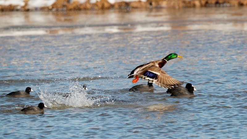
In the photo top, a mallard drake makes his escape awa from a group of coots in an area of Halowell Reservoir in this undated photo by AGFC photographer Mike Wintroath.
Northeast Arkansas
Big Lake WMA
Map | Water Gauge | Weather Report
When the Ditch 81 extension gauge near Manila (upstream of the Big Lake north-end control structure) reads 17.5 feet, water is beginning to come over the north levee degrade on Big Lake WMA. When the Ditch 81 Extension gauge reads 18.0 feet or higher, the water level on the WMA will rise quickly and hunters should exercise caution while on the area. Be aware of underwater logs in boat runs and hangers in trees.
North Woods GTR
Habitat: Mast production is good.
Water Level: Gauge reading at BoDoc is unreadable, water level is above gauge; target level is 235.5 feet with 100% flooded.
South Woods GTR
Habitat: Mast production is fair.
Water Level: Reading at the 7-Mile gauge on Monday was 236.8 feet msl; target level is 234.5 feet with 100% flooded.
Simmons Field
Habitat: Good production of millet and sedge. Native production is good in the north, middle and south fields.
Water Level: 100% coverage.
Reports of a few ducks moving across the area.
Dave Donaldson Black River WMA
Map | Water Gauge | Weather Report
Waterfowl hunters should be aware of hangers and submerged logs within the boat runs and GTRs. Please exercise caution when accessing the area. Please remember to keep boats off the levees so AGFC personnel can access the area. Boats blocking access will be moved. Unattended trailers are not to be left overnight on parking areas. River level as of Monday was 11.29 feet and rising.
Upper Island GTR
Habitat: Mast crop is moderate within the GTRs.
Water Level: Gauge is inaccessible due to high water. Target level is 269.5; 100% flooded.
Lower Island GTR
Habitat: Mast crop is moderate within the GTRs.
Water Level: Gauge is inaccessible due to high water. Target level is 268.0; 100% flooded.
Upper Reyno GTR
Habitat: Mast crop is moderate within the GTRs.
Water Level: Current level is 268.35 feet msl. Target level is 266.9; 100% flooded.
Lower Reyno GTR
Habitat: Mast crop is moderate within the GTRs.
Water Level: Current level is 268.2 msl. Target level is 266.3; 100% flooded.
Winchester GTR
Habitat: Mast crop is moderate within the GTRs.
Water Level: Current level is 265.4 feet msl. Target level is 263.7; 100% flooded.
Earl Buss Bayou DeView WMA
Map | Water Gauge | Weather Report
Boaters should use caution while using the Thompson Tract boat run.
South Oliver GTR
Habitat: Mast production is good.
Water Level: 100% flooded with a gauge reading on Jan. 10 of 1.7 feet.
Thompson Tract GTR
Habitat: Mast production is good.
Water Level: 100% flooded with a gauge reading of 1.8 feet. The Thompson Tract GTR will be allowed to rise and fall naturally without the gates being operated beginning with this season. This action is an effort to help the next generation of forest.
Lake Hogue WRA
Habitat: Primarily deep open water habitat.
Water Level: Normal pool level.
Shirey Bay Rainey Brake WMA
Map | Water Gauge | Weather Report
Waterfowl hunters should be aware of hangers and submerged logs within the boat runs and GTRs. Please exercise caution when accessing the area. In addition, hunters should allow safe passage when parking vehicles along roadsides. Vehicles blocking access will be moved.
Adam Brake GTR
Habitat: Mast production is good.
Water Level: Water level is 240.8 feet msl with a target level of 240.0 feet msl; 100% flooded.
Rainey Brake GTR
Habitat: Mast production is good.
Water Level: 100% flooded.
Eagle Pond GTR
Habitat: Mast production is good.
Water Level: 100% flooded.
Phase III Moist-Soil Unit
Habitat: Good wetland-type vegetation.
Water Level: 98% flooded.
Charles Crisp Moist-Soil Unit
Habitat: Good wetland-type vegetation.
Water Level: 100% flooded.
Ward Field Moist-Soil Unit
Habitat: Good wetland-type vegetation.
Water Level: 100% flooded.
River Field Moist-Soil Unit
Habitat: Good wetland-type vegetation.
Water Level: 100% flooded.
St. Francis Sunken Lands WMA
Map | Water Gauge | Weather Report
Hunt Area
Habitat: Good mast production within the hunt area.
Water Level: Water levels on St. Francis Sunken Lands for waterfowl season are dependent on flows from the St. Francis River. The target level for providing huntable timber is 212.0 feet msl at the Oak Donnick gauge. As of Jan. 3, the reading was 216.7 feet msl.
Snowden WRA
Habitat: Mixed grasses.
Water Level: 20% flooded, mostly in the low-lying areas due to rain.
Payneway WRA
Habitat: A, B, C and D pools have mixed smartweed and barnyard grasses. Moderate mast is available within pools A, B and C as well.
Water Level: Pool A is at 20% coverage. Pool B is at 30%. Pool C is at 50%. Pool D is at 80%.
East-Central Arkansas
Henry Gray Hurricane Lake WMA
Map | Water Gauge | Weather Report
Hunters should call the Wildlife Hotline at 800-440-1477 for current road closures.
North Unit
Habitat: Good mast crop.
Water Level: The White River at Augusta as of Tuesday, Jan. 11, was 30.39 feet and rising. All structures on the North GTR will remain open during the 2021-22 season.
South Unit
Habitat: Fair mast crop.
Water Level: The White River at Augusta is 30.39 feet msl and rising. All structures on the South Unit are open.
Rex Hancock Black Swamp WMA
Map | Water Gauge | Weather Report
Hunters should call the Wildlife Hotline at 800-440-1477 for current road closures.
Gregory GTR
Habitat: Good mast crop.
Water Level: 95% (Cache River at Patterson was at 11.17 feet as of Jan. 11 and starting to rise.
Wiville Moist-Soil Unit
Habitat: Good stand of millet and native vegetation.
Water Level: 50% coverage.
Sheffield Nelson Dagmar WMA
Map | Water Gauge | Weather Report
The Conway George units are currently available for hunting by applying for online permits. Youths may apply for Saturday and Sunday hunts, with one adult hunter allowed per one youth, up to four hunters in the blind. All ages may apply for Wednesday hunts. Please visit www.agfc.com for maps, special regulations, permit application and draw dates. Hunters should call the Wildlife Hotline at 800-440-1477 for current road closures. The AGFC will not be putting boards in at Dagmar. Water coverage is dependent on river level.
Mud Slough GTR
Habitat: Good mast crop.
Water Level: 75% coverage.
Apple Lake WRA (no hunting)
Habitat: Good mast crop.
Water Level: 80%.
Conway George Waterfowl Unit A
Habitat: Good stand of millet and native vegetation.
Water Level: 100%
Conway George Waterfowl Unit B
Habitat: Natural slough area with beneficial native wetland plants.
Water Level: 100%
Conway George Waterfowl Unit C
Habitat: Good stand of millet and native vegetation.
Water Level: 100%
Dark Corner Waterfowl Unit 1
Habitat: Good stand of millet and native vegetation.
Water Level: 100%
Dark Corner Waterfowl Unit 2
Habitat: Good stand of millet and native vegetation.
Water Level: 50%
Dark Corner Waterfowl Unit 3
Habitat: Good stand of millet and native vegetation.
Water Level: 100%
Steve N. Wilson Raft Creek Bottoms WMA
Hunting in Raft Creek Bottoms WMA requires participation on the online draw a week before the following weekend’s hunt. There is no online draw on Tuesdays and Thursdays, and permits are available at the boat accesses. Permits ARE required (via online application) on weekends, Tuesdays and Thursdays for the youth and mobility-impaired blinds and for the Magellan Tract. Visit agfc.com to apply for the online draw. There will be no designated holes this season.
The gauge on the White River at Georgetown on Tuesday, Jan. 11, at 1 p.m. was 18.69 feet and holding. If the gauge reaches 19 feet, all weekend permits are no longer valid. Hunting is allowed. Water will be deep in some units, such as Unit 1. WMA units closer to Georgetown wil be shallower than the ones on the west end.
Map | Water Gauge | Weather Report
Unit A
Habitat: Excellent stand of native vegetation.
Water Level: 100% coverage.
Unit B
Habitat: Excellent stand of millet and native vegetation.
Water Level: 100%
Unit C
Habitat: Good stand of native vegetation.
Water Level: 100%
Unit D
Habitat: Good stand of native vegetation.
Water Level: 95%
Unit E
Habitat: Excellent stand of millet and native vegetation.
Water Level: 95%
Unit F (Youth Area)
Habitat: Good stand of millet and native vegetation.
Water Level: 100%
Unit G
Habitat: Fair stand of millet and native vegetation.
Water Level: 0%
Unit H (Mobility-impaired blind)
Habitat: Excellent stand of native vegetation.
Water Level: 100%
Unit I
Habitat: Habitat conditions are poor.
Water Level: 0%
Unit J (Cypert Tract)
Habitat: Excellent stand of native vegetation.
Water Level: 95%
Unit K (Cypert Tract)
Habitat: Excellent stand of native vegetation.
Water Level: 25%
Unit L (Cypert Tract)
Habitat: Fair stand of native vegetation.
Water Level: 0%
Unit M (Magellan Tract)
Habitat: Fair stand of native vegetation.
Water Level: 80%
Central Arkansas
Bell Slough WMA
Map | Weather Report
The Bell Slough GTR is primarily rainfall dependent with the exception of a limited amount of water that the AGFC can back in and catch from Palarm Creek.
Bell Slough GTR
Habitat: Poor mast crop.
Water Level: 100%.
Palarm Creek WRA
Habitat: Fair stand of planted millet.
Water Level: 100%
Craig D. Campbell Lake Conway Reservoir
Map | Weather Report
Habitat and water levels are normal on both Pierce and Dix creeks.
Cypress Bayou WMA
Hunt Area
Habitat:
Good mast crop.
Water Level: 100% coverage.
Red Cut Slough Tract
Unit 1
Habitat:
Habitat conditions are poor.
Water Level: 25%
Unit 2
Habitat:
Excellent stand of millet and native vegatation
Water Level: 25%
Unit 3
Habitat:
Good stand of millet and native vegatation
Water Level: 100%
Unit 4
Habitat: Good stand of millet and native vegetation.
Water Level: 100%
Unit 5
Habitat:
Good stand of native vegetation.
Water Level: 100%
Unit 6
Habitat:
Good stand of native vegetation.
Water Level: 85%
Harris Brake WMA
Upper GTR
Habitat: Below average mast crop.
Water Level: 100%.coverage,
Lower GTR
Habitat: Below average mast crop.
Water Level: 100% coverage. Water is over Steamboat Road.
Holland Bottoms WMA
Hunt Area
Habitat: Good mast crop.
Water Level: 80% coverage.
Lake Pickthorne WRA (no hunting)
Habitat: Excellent crop of native vegetation and millet.
Water Level: East cell is 100%, West cell is 100%.
Northwest Arkansas
Dardanelle WMA
McKennon Bottoms (half-day hunting)
Habitat: Good stand of native vegetation.
Water Level: 100% coverage
Potter’s Pothole Hartman Waterfowl Unit (half-day hunting)
Habitat: West cell has a good stand of Japanese millet. East cell has a poor stand of Japanese millet.
Water Level: 100% coverage
Ed Gordon Point Remove WMA
Recent rainfall events have greatly improved conditions on Ed Gordon Point Remove WMA, and all waterfowl impoundments are at or near full pool at this time.
Duck use on the WMA has been low to moderate and hunter success been poor to fair.
Little Hole (Unit 1)
Habitat: Japanese millet.
Water Level: 100% flooded.
Willow Island (Unit 2)
Habitat: Japanese millet and natural vegetation.
Water Level: 100%
Red Gate (Unit 3)
Habitat: Natural vegetation
Water Level: 100%
Pig Trough (Units 4 and 5)
Habitat: Natural vegetation and Japanese millet.
Water Level: 100%
Cedar Ridge (Unit 6)
Habitat: Natural vegetation.
Water Level: 100%
Unit 7a
Habitat: Natural vegetation.
Water Level: 100%
Unit 7b
Habitat: Japanese millet and natural vegetation.
Water Level: 100%
Duck Trap (Units 8a, 8b and 8c)
8a
Habitat: Natural vegetation.
Water Level: 90%
8b
Habitat: Natural vegetation.
Water Level: 90%
8c
Habitat: Natural vegetation.
Water Level: 90%
Unit 9
Habitat: Japanese millet and natural vegetation.
Water Level: 100%
Controversy Corner (Unit 10)
Habitat: Natural vegetation.
Water Level: 100%
Remmel Marsh
Habitat: Natural vegetation and Japanese millet.
Water Level: 90%
Mud Pond (Unit 12)
Habitat: Natural vegetation and Japanese millet.
Water Level: 100%
Turkey Pond (Units 13a, 13b and 13c)
13a
Habitat: Natural vegetation.
Water Level: 100%
13b
Habitat: Natural vegetation.
Water Level: 90%
13c
Habitat: Natural vegetation.
Water Level: 100%
Teeny Pond (Unit 14)
Habitat: Natural vegetation.
Water Level: 100%
Salt Lick (Unit 15)
Habitat: Natural vegetation.
Water Level: 100%
Bobby’s Pond (Unit 16)
Habitat: Natural vegetation.
Water Level: 100%
Race Track (Unit 17)
Habitat: Natural vegetation.
Water Level: 100%
Frog Bayou WMA (half-day hunting)
Unit 1
Habitat: Good stand of moist-soil vegetation.
Water Level: 100% coverage
Unit 2
Habitat: Poor stand of moist-soil vegetation.
Water Level: 100% flooded.
Unit 3
Habitat: Good stand of moist-soil vegetation and planted millet.
Water Level: 100%
Unit 4
Habitat: Good stand of moistl-soil vegetation and planted millet
Water Level: 100%
Unit 5
Habitat: Good stand of moist-soil vegetation on the upper end, lower end has been fallow-disked.
Water Level: 100%
Unit 6
Habitat: Good stand of moist-soil vegetation.
Water Level: 80%
Unit 7
Habitat: Good stand of moist-soil vegetation.
Water Level: 100%
Galla Creek WMA
Galla Creek GTR
Habitat: Good stands of native vegetation, including a mixture of barnyard grass, annual smartweeds and sprangletop.
Water Level: 100% flooded. The waterfowl impoundment at Galla Creek WMA is at full pool at this time.
Nimrod Lloyd Millwood WMA
Nimrod GTR
Habitat: The red oak mast crop is poor this year but the desirable native vegetation growth is better than in previous years. Due to abnormally dry conditions, this area is not expected to fill up as fast as in previous years. The water-control structures were closed on Nov. 17. This area is rainfall dependent to flood.
Water Level: 40% flooded
Ozark Lake WMA/Dyer Lake Water Unit
Dyer Lake Cells (half-day hunting)
Units 1 and 2
Habitat: Good stand of moist-soil vegetation and planted millet
Water Level: 100% coverage for both units
Unit 3 South Cell
Habitat: Good stand of moist-soil vegetation and volunteer millet
Water Level: 10% coverage
Unit 4 West Cell (rainfall dependent)
|Habitat: Poor stand of moist-soil vegetation
Dyer West Cell: Less than 25% coverage
Petit Jean River WMA
Map | Water Gauge | Weather Report
Sorehead Moist-Soil Unit
Habitat: Due to ongoing waterfowl habitat enhancement projects, this unit was not able to grow any food this year. Work is still ongoing as long as this area stays dry. The Kingfisher Lake water-control structure valve was opened on Nov. 17 to help flood this area.
Water Level: 90%
Blacklands Moist-Soil Unit
Habitat: This unit this year contains one of the best stands of desirable native vegetation in recent years. The wooded areas inside the unit produced a poor red oak mast crop this year. Due to abnormally dry conditions and low river levels, this area is not expected to fill up as fast as in previous years. The river level is still too low to properly pump.
Water Level: 100%.
Slaty Crossing Moist-Soil Unit
Habitat: Due to ongoing waterfowl habitat enhancement projects, this unit was not able to grow a desirable native vegetation crop this year. The area was seeded with millet after the project was completed. The area yielded a great stand of planted millet. Due to abnormally dry conditions and low river levels, this area is not expected to fill up as fast as in previous years.
Water Level: 100%
Blacklands Duck Area
Habitat: The wooded sections of this area produced a poor red oak mast crop this year. This area also contains a mix of moderate to great stands of desirable native vegetation mixed throughout. The Kingfisher Lake water-control structure valve was opened on Nov. 17 to help flood this area.
Water Level: 90%
Pullen Pond Marsh
Habitat: Due to ongoing waterfowl habitat enhancement projects, parts of the central section of this area is bare ground. Most of the area has amazing stands of desirable native vegetation. The desirable native vegetation has started to become more and more prevalent with each year of ongoing management work. Work is still ongoing until the area becomes too wet to work. This area is rainfall dependent to flood.
Water Level: 70%.
Pond Creek GTR
Habitat: This area produced a poor red oak mast crop this year with good stands of desirable native vegetation in the open lands within this area. Due to abnormally dry conditions, this area is not expected to fill up as fast as in previous years. The water-control structures were closed on Nov. 16. This area is rainfall dependent to flood.
Water Level: 10%. Flooding of this area is rainfall dependent.
Slaty GTR
Habitat: This area produced a poor red oak mast crop this year with good stands of desirable native vegetation in the open lands within this area. Due to abnormally dry conditions, this area is not expected to fill up as fast as in previous years. The water-control structure was closed on Nov. 16.
Water Level: 10%. Flooding of this area is rainfall dependent.
Santa Fe GTR
Habitat: This area produced a lpoor red oak mast crop this year with good stands of desirable native vegetation in the open lands within this area. Due to abnormally dry conditions, this area is not expected to fill up as fast as in previous years. The water-control structures were closed on Nov. 16.
Water Level: 100%. Flooding of this area is rainfall dependent.
Southwest Arkansas
Dr. Lester Sitzes III Bois d’Arc WMA
Bois d’Arc Lake WRA
Habitat: Closed to hunting.
Water Level: Normal
Red Slough WRA
Habitat: Closed to hunting.
Water Level: 70% coverage.
GTR
Habitat: Good mast production.
Water Level: 90%. Water control structures were closed Dec. 1.
Little Grassy
Habitat: Good
Water Level: 80%
Millwood Lake
Map | Water Gauge | Weather Report
Habitat: Habitat conditions are good.
Water Level: Millwood is at 259.5 feet msl as of Jan. 11.
Ozan WMA
Flooding of all units is rainfall dependent.
Unit 1
Habitat: Good
Water Level: 5%
Unit 2
Habitat: Good
Water Level: 0%
Unit 3
Habitat: Good
Water Level: 0%
Unit 4
Habitat: Good
Water Level: 0%
Unit 5
Habitat: Good
Water Level: 0%
Sulphur River WMA
Mercer Bayou
Habitat: Fair
Water Level: 40%
Henry Moore WRA
Habitat: Closed to hunting.
Water Level: 75%
Southeast Arkansas
Beryl Anthony Lower Ouachita WMA
Map | Weather Report
Water Level: No duck hunting water. Water is available in the oxbow lakes located in the WMA.
Cut-Off Creek WMA
Hunt Area
Habitat: Habitat conditions are good.
Water Level: Some water in low areas only.
Pigeon Creek WRA
Habitat: Habitat conditions are good.
Water Level: Pumping as water conditions allow.
Freddie Black Choctaw Island WMA Deer Research Area
Map | Water Gauge | Weather Report
Habitat conditions are good. Flooding is river dependent. Click on the Water Gauge link above for current Mississippi River levels. Use extreme caution when boating in river.
The Freddie Black Choctaw Island WMA West Unit allows weekend permit hunting for youths (one adult per youth hunter); on Wednesdays, all ages may apply for a permit to hunt the blinds in the West Unit. Currently, the area is dry and there have been no online draws for the West Unit.
George H. Dunklin Jr. Bayou Meto WMA
Map | Water Gauge | Weather Report
The UGSG is reporting real-time water gauge readings at the headwater at each GTR within the George H. Dunklin Bayou Meto WMA. Click the Water Gauge link above for the WMA, and search for the particular GTR as noted.
NOTE: During the 2021-22 wintering period, all intentional flooding will be held at 179 feet msl, an elevation that will relieve stress on many of trees such as red oaks that are showing signs of distressed. Rain and increased flow into the WMA will allow water to rise above that level periodically, but artificial flooding will be stopped at the 179 feet msl mark. A good rule of thumb for comparing water levels to access into Bayou Meto: 176 feet msl – water breaking into sloughs and lower ditches; 177-177.5 feet msl – water beginning to break out of sloughs and lower ditches; 178 feet msl – water in most sloughs and ditches and entering into lower elevations in woods; 178.5 feet msl – most ditches and sloughs deep enough to boat and most boat ramps become serviceable; 179 feet msl or above – good duck hunting waters.
Upper Vallier GTR
Habitat: Good
Water Level: Water at 179.55 feet msl as of Jan. 12. See Gauge Link (Upper Vallier Headwater)
Lower Vallier GTR
Habitat: Good
Water Level: Water at 179.68 feet msl as of Jan. 12. See Gauge Link (Lower Vallier Headwater).
Government Cypress GTR
Habitat: Good
Water Level: Water at 179.97 feet msl as of Jan. 12. See Gauge Link (Government Cypress Headwater)
Buckingham Flats GTR
Habitat: Good
Water Level: Full pool. See Gauge Link (Buckingham Flats Headwater).
Temple Island GTR
Habitat: Good
Water Level: Full pool. See Gauge Link (Temple Island Headwater).
Canon Brake
Habitat: Good
Water Level: See Gauge Link (Canon Brake Headwater).
Halowell WRA
Habitat: Excellent
Water Level: Staggered flooding of units.
Wrape Plantation WRA
Habitat: Excellent
Water Level: Staggered flooding of units.
Seven Devils WMA
Hunt Area
Habitat: Habitat conditions are good.
Water Level: Water is running over east side spillway.
Trusten Holder WMA
Map | Water Gauge | Weather Report
Habitat conditions are good. Flooding is river dependent. Click on the Water Gauge link above for current Arkansas River levels.
Recent News
Subscribe to Our Weekly Newsletter E-mails
Don’t miss another issue. Sign up now to receive the AGFC Wildlife Weekly Newsletter in your mailbox every Wednesday afternoon (Waterfowl Reports are published weekly during waterfowl season and periodically outside the season). Fishing Reports arrive on Thursdays. Fill in the following fields and hit submit. Thanks, and welcome!