Arkansas Wildlife Waterfowl Report
BY Jim Harris
ON 11-17-2021
Nov. 17, 2021
Jim Harris
Managing Editor Arkansas Wildlife Magazine
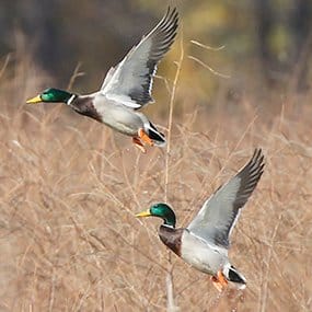
Duck Season Opens Saturday With Hopes for Better Results Than Last Year
LITTLE ROCK – Arkansas duck hunters will begin the 2021-22 season Saturday with hopes for a better overall season than last year, when the region saw a noticeable drop in annual average number of ducks that typically pass through the state. Much of that was due to the dry conditions and lack of habitat around Arkansas that lasted well into December, according to Luke Naylor, the Arkansas Game and Fish Commission’s waterfowl program coordinator.
This year’s opener may begin under even drier conditions and less waterfowl habitat across the state, Naylor noted. Many the public hunting areas in Arkansas had little to no water in the days leading up to the season opener. Some creeks and rivers that provide water for the wildlife management areas that the AGFC’s managed for ducks are below gauge or are too low for pumps to move water into the huntable areas.
“I’ve been driving around a lot around the state and it’s a really, really dry landscape now. We haven’t had a substantial rain,” Naylor said. “Surface water is in short supply. We have seen private land owners and our (WMA) managers trying to provide water where we can. But we’re purposely not going to go to full pool in some areas that we can flood, but rather we will use staggered flooding that allows us to help the resource last for a long time.”
Naylor did see some ducks within the state, though.
“I’ve seen some pretty nice concentrations of ducks in places that have good resources and water,” he said. “Success shooting ducks this early could be fairly short-lived, though, with such limited water and as ducks change their patterns and figure out ways to avoid the shotguns. I don’t expect a lot of change until we take on a major rain.”
Last year’s season saw a drop in total duck observations and mallard sightings during the AGFC’s scheduled winter flyovers for surveys. Numbers picked up in January, but still finished below the longterm average. Much success for this season, of course, also depends on what happens north of Arkansas as to whether the numbers return to 2019-20 estimates, and habitat conditions throughout the Mississippi Flyway were below average for the most part last year. The first major snow and ice storm didn’t arrive in the upper midwestern states until around Christmastime, and temperatures were unusually warm in the Dakotas late in 2020.
Despite few sightings of ducks by the aerial surveys (one in December, two in January) last year, the harvest counts that were produced by the U.S. Fish and Wildlife Service in late summer indicated that Arkansas’s harvest-per-hunter average actually slightly increased over the previous season, to over 15 ducks per hunter. Arkansas still was the state in the Mississippi Flyway with the most mallards harvested.
Duck season begins 30 minutes before sunrise starting Saturday, Nov. 20, with the day’s shooting done at sunset. Daily bag limits are unchanged from last year: 6 ducks, which may include no more than 4 mallards (2 hens), 1 scaup, 3 wood ducks, 1 pintail, 2 redheads, 2 canvasbacks, 2 black ducks, 1 mottled duck. If not listed, up to 6 ducks of a species (such as teal) may be taken. The coot daily bag limit is 15 and the merganser daily limit is 5, which may include no more than 2 hooded mergansers.
* * *
Looking for a spot to call your own for a day or even a weekend during duck season? Check out some of the online draw opportunities available through the Arkansas Game and Fish Commission. In addition to permit hunts on Steve N. Wilson Raft Creek Bottoms WMA, the Red Cut Slough tract at Cypress Bayou WMA, the Conway George tract at Sheffield Nelson Dagmar WMA and Freddie Black Choctaw Island West Unit WMA, the AGFC will have up to 45 privately owned flooded rice fields available to hunt by permit through its special duck hunting application process this season.
Wil Hafner, director of the AGFC’s Potlatch Cook’s Lake Nature Center in Casscoe, was fortunate enough to draw one of these WRICE Program fields last weekend for a greater white-fronted goose hunt before the opening of duck season. He, his fiend T.A. Lewis, and T.A.’s father, Blake, were able to score a limit of geese on Saturday by 6:52 a.m. They returned Sunday, and although they only managed four specklebellies, they had a blast.
“These fields are great opportunities for seasoned waterfowlers and beginners alike,” Hafner said. “I am very impressed with this program.”
Applications for all draw hunts are open from 3 p.m. Thursday through midnight Sunday night the weekend immediately preceding the weekend for which you are applying. Applicants are notified whether they win or not each Monday morning, so they may plan for their hunt. Visit
https://www.agfc.com/en/hunting/migratory-birds/waterfowl/special-waterfowl-permit-hunts to learn more about these special duck-hunting opportunities and to apply.
Luke Naylor, the AGFC’s waterfowl program coordinator, said that about 30-35 of the private-land leases were available for application for the draw this past weekend, and he said Wednesday that those fields all “should have water in them.” Those fields will be flooded in a staggered method to maintain resources for as long as possible through the season. Naylor noted that one field he saw this week had a significant number of geese using it, and he says that hunters should expected to find some birds in the WRICE fields.
* * *
Hunting for geese has been underway, either through the Lesser Goose Conservation Order for snows, blues and Ross’s goose, or with the early opening to greater white-fronted geese (or specklebellies), which started Oct. 30. The speck season runs through the end of duck season, Jan. 31, and, with just a one-day exception in early December and the two-day Christmas holiday break, does not stop for the split during duck season. Only youths, veterans and active duty military will be able to hunt waterfowl on Dec. 4. Specklebelly season will be open to all hunters through Dec. 3, then resume on Dec. 5 and continue until Jan. 31, with the two days off for all waterfowl hunting Dec. 24-25, in the second year of an 88-day season (only two birds can be harvested daily).
* * *
Waterfowl hunters are urged to remember, as they embark on the water for the first time since maybe their boat has been on the water in several months, that they need to clean, drain and dry all of your equipment, including decoys along with your boating investment, and make sure to repeat the process after leaving the water body.
AGFC biologists urge hunters, as well as anglers and other boaters, to take the extra time to clean all their equipment of mud and vegetation before bringing it back to the wetlands. Nuisance vegetation fragments, seeds and other undesirables can hit a ride almost unnoticed even on duck decoys, weights and strings, not to mention hard-to-get-to areas of your boat and motor after a season spent all over a particular water body.
The spread of invasive aquatic plants typically is associated with spring and summer boating because that’s when the plants grow the fastest and become a nuisance, especially in the southern half of the state. But AGF biologists note that if boaters and hunters move around the state, or even within the same area of the state, you could unknowingly spread these plants during your hunt. Plant fragments can survive from the warmer recent months, and the seeds from the plants also will be viable to carry on into the next spring. Some of the swampy backwater areas duck hunters scout and hunt offer the perfect out-of-the-way place for these plants to establish themselves and spread even further.
The problem doesn’t just impact boaters, either. Millions of dollars are spent throughout the U.S. to combat invasive species every year. That’s money that should be spent on improving habitat, but must be used to prevent further infestation of these harmful exotic plants.
In 2020, more than $250,000 was spent in Arkansas fighting aquatic invasive plants, a 20 percent increase from the year before. Without hunters’ help, this trend could continue. So, please: Clean all equipment – Remove all plants and pieces of vegetation, seeds and mud off your waders, decoys, boat, truck, blind and trailer.
Drain your boat – Remove the drain plug from your boat when you leave the water.
Dry – Let all gear dry for at least five days before visiting new waters. If drying is not an option, spray all equipment with a high-pressure hose or hot water.
Visit www.cleandraindry.org or click below for more information about invasive species and what hunters can do to help.
Northeast Arkansas
Big Lake WMA
Map | Water Gauge | Weather Report
When the Ditch 81 extension gauge near Manila (upstream of the Big Lake north-end control structure) reads 17.5 feet, water is beginning to come over the north levee degrade on Big Lake WMA. When the Ditch 81 Extension gauge reads 18.0 feet or higher, the water level on the WMA will rise quickly and hunters should exercise caution while on the area. Be aware of underwater logs in boat runs and hangers in trees.
North Woods GTR
Habitat: Mast production is good.
Water Level: Water level is below gauge at BoDoc; target level is 235.5 feet with 0% now flooded.
South Woods GTR
Habitat: Mast production is fair.
Water Level: Water level is below the 7-Mile gauge; target level is 234.5 feet with 2% now flooded, lateral ditches and come borrow pits are flooded.
Simmons Field
Habitat: Good production of millet and sedge. Native production is very good in the north, middle and south fields.
Water Level: 0% coverage.
Dave Donaldson Black River WMA
Map | Water Gauge | Weather Report
Waterfowl hunters should be aware of hangers and submerged logs within the boat runs and GTRs. Please exercise caution when accessing the area. Please remember to keep boats off the levees so AGFC personnel can access the area. Boats blocking access will be moved. Unattended trailers are not to be left overnight on parking areas. River level is 2.9 feet and falling.
Upper Island GTR
Habitat: Mast crop is moderate within the GTRs.
Water Level: Current level is below the gauge. Target level is 269.5; 10% flooded.
Lower Island GTR
Habitat: Mast crop is moderate within the GTRs.
Water Level: Current level is below the gauge. Target level is 268.0; 10% flooded.
Upper Reyno GTR
Habitat: Mast crop is moderate within the GTRs.
Water Level: Current level is 264.55 msl. Target level is 266.9; 5% flooded.
Lower Reyno GTR
Habitat: Mast crop is moderate within the GTRs.
Water Level: Current level is 263.45 msl. Target level is 266.3; 5% flooded.
Winchester GTR
Habitat: Mast crop is moderate within the GTRs.
Water Level: Current level is be;pw tje gauge. Target level is 263.7 msl; 5% flooded.
Earl Buss Bayou DeView WMA
Map | Water Gauge | Weather Report
Boaters should use caution while using the Thompson Tract boat run.
South Oliver GTR
Habitat: Mast production has been good.
Water Level: 0% flooded
Thompson Tract GTR
Habitat: Mast production is good.
Water Level: 0% flooded. The Thompson Tract GTR will be allowed to rise and fall naturally without the gates being operated beginning with this season. The action is an effort to help the next generation of forest.
Lake Hogue WRA
Habitat: Primarily deep open water habitat.
Water Level: Normal pool level.
Shirey Bay Rainey Brake WMA
Map | Water Gauge | Weather Report
Waterfowl hunters should be aware of hangers and submerged logs within the boat runs and GTRs. Please exercise caution when accessing the area. In addition, hunters should allow safe passage when parking vehicles along roadsides. Vehicles blocking access will be moved.
Adam Brake GTR
Habitat: Mast production is good.
Water Level: Water level is blow the gauge with a target level of 240.0 msl; 0% flooded.
Rainey Brake GTR
Habitat: Mast production is good.
Water Level: 0% flooded.
Eagle Pond GTR
Habitat: Mast production is good.
Water Level: 0% flooded.
Phase III Moist-Soil Unit
Habitat: Good wetland-type vegetation.
Water Level: 30% flooded.
Charles Crisp Moist-Soil Unit
Habitat: Good wetland-type vegetation.
Water Level: 30% flooded.
Ward Field Moist-Soil Unit
Habitat: Good wetland-type vegetation.
Water Level: 30% flooded.
River Field Moist-Soil Unit
Habitat: Good wetland-type vegetation.
Water Level: 30% flooded.
St. Francis Sunken Lands WMA
Map | Water Gauge | Weather Report
Hunt Area
Habitat: Good mast production within the hunt area.
Water Level: Water levels on St. Francis Sunken Lands for waterfowl season are dependent on flows from the St. Francis River. The target level for providing huntable timber is 212.0 feet msl at the Oak Donnick gauge. As of Nov. 16, the reading was 211.28 feet msl.
Snowden WRA
Habitat: Mixed grasses.
Water Level: 2% flooded
Payneway WRA
Habitat: A, B, C and D pools have mixed smartweed and barnyard grasses. Moderate mast is available within pools A, B and C as well.
Water Level: Pool A is at 0% coverage. Pool B is at 0%. Pool C is at 0%. Pool D is at 0%.
East-Central Arkansas
Henry Gray Hurricane Lake WMA
Map | Water Gauge | Weather Report
Hunters should call the Wildlife Hotline at 800-440-1477 for current road closures.
North Unit
Habitat: Good mast crop.
Water Level: 0%. The water level was below the gauge at in Glaise Creek. All structures throughout the WMA will remain open this season.
South Unit
Habitat: Good mast crop.
Water Level: 0%. The water level was below the gauge at in Glaise Creek. All structures throughout the WMA will remain open this season.
Rex Hancock Black Swamp WMA
Map | Water Gauge | Weather Report
Hunters should call the Wildlife Hotline at 800-440-1477 for current road closures.
Gregory GTR
Habitat: Good mast crop.
Water Level: 0% (the Cache River level is 3,7 feet and rising on the Patterson gauge).
Wyeville Moist-Soil Unit
Habitat: Good stand of millet and native vegetation.
Water Level: 0% coverage. Pumping was to begin Nov. 17.
Sheffield Nelson Dagmar WMA
Map | Water Gauge | Weather Report
The Conway George units are currently available for hunting by applying for online permits. Youths may apply for Saturday and Sunday hunts, with one adult hunter allowed per one youth, up to four hunters in the blind. All ages may apply for Wednesday hunts. Please visit www.agfc.com for maps, special regulations, permit application and draw dates. Hunters should call the Wildlife Hotline at 800-440-1477 for current road closures. The AGFC will not be putting boards in at Dagmar. Water coverage is dependent on river level.
Mud Slough GTR
Habitat: Good mast crop.
Water Level: 0% coverage.
Apple Lake WRA (no hunting)
Habitat: Good mast crop.
Water Level: 70%.
Conway George Waterfowl Unit A
Habitat: Good stand of millet and native vegetation.
Water Level: 100%
Conway George Waterfowl Unit B
Habitat: Natural slough area with beneficial native wetland plants.
Water Level: 80%
Conway George Waterfowl Unit C
Habitat: Good stand of millet and native vegetation.
Water Level: 0%. Pumping will begin in December.
Steve N. Wilson Raft Creek Bottoms WMA
Hunting in Raft Creek Bottoms WMA requires participation on the online draw a week before the next weekend’s hunt. There is no online draw on Tuesdays and Thursdays, and permits are available at the boat accesses. Permits ARE required (via online application) on weekends, Tuesdays and Thursdays for the youth and mobility-impaired blinds and for the Magellan Tract. Visit agfc.com to apply for the online draw. There will be no designated holes this season; however, the hole markers used in the past will still be in place so hunters can navigate the area.
Map | Water Gauge | Weather Report
Unit A
Habitat: Excellent stand of native vegetation.
Water Level: 90% coverage.
Unit B
Habitat: Excellent stand of millet and native vegetation.
Water Level: 7%
Unit C
Habitat: Good stand of native vegetation.
Water Level: 85%
Unit D (Youth Area)
Habitat: Good stand of native vegetation.
Water Level: 85%
Unit E
Habitat: Excellent stand of millet and native vegetation.
Water Level: 85%
Unit F (Youth Area)
Habitat: Good stand of millet and native vegetation.
Water Level: 100%
Unit G (Mobility-impaired Blind)
Habitat: Fair stand of millet and native vegetation.
Water Level: 100%
Unit H (Mobility-impaired blind)
Habitat: Excellent stand of native vegetation.
Water Level: 100%
Unit I
Habitat: Habitat conditions are poor.
Water Level: 0%
Unit J (Cypert Tract)
Habitat: Excellent stand of native vegetation.
Water Level: 80%
Unit K (Cypert Tract)
Habitat: Excellent stand of native vegetation.
Water Level: 5%
Unit L (Cypert Tract)
Habitat: Fair stand of native vegetation.
Water Level: 0%
Unit M (Magellan Tract)
Habitat: Fair stand of native vegetation.
Water Level: 75%
Central Arkansas
Bell Slough WMA
Map | Weather Report
The Bell Slough GTR is primarily rainfall dependent with the exception of a limited amount of water that the AGFC can back in and catch from Palarm Creek.
Bell Slough GTR
Habitat: Poor mast crop.
Water Level: 20%.
Palarm Creek WRA
Habitat: Fair stand of planted millet.
Water Level: 30%
Craig D. Campbell Lake Conway Reservoir
Map | Weather Report
Habitat and water levels are normal on both Pierce and Dix creeks.
Cypress Bayou WMA
Hunt Area
Habitat:
Good mast crop.
Water Level: 100% coverage.
Red Cut Slough Tract
Unit 1
Habitat:
Habitat conditions are poor.
Water Level: 0%
Unit 2
Habitat:
Excellent stand of millet and native vegatation
Water Level: 0%
Unit 3
Habitat:
Good stand of millet and native vegatation
Water Level: 0%
Unit 4
Habitat: Good stand of millet and native vegetation.
Water Level: 0%
Unit 5
Habitat:
Good stand of native vegetation.
Water Level: 0%
Unit 6
Habitat:
Good stand of native vegetation.
Water Level: 0%
Harris Brake WMA
Upper GTR
Habitat: Below average mast crop this year.
Water Level: 0%.
Lower GTR
Habitat: Below average mast crop.
Water Level: 0% flooded. Note: The water control structures on both the Lower and Upper GTRs were closed on Monday, Nov. 15. The Harris Brake Lake valve was opened on Nov. 15 to begin supplemental flooding of both the Lower and Upper GTRs.
Holland Bottoms WMA
Hunt Area
Habitat: Good mast crop.
Water Level: 0% coverage.
Lake Pickthorne WRA (no hunting)
Habitat: Excellent crop of native vegetation and millet.
Water Level: East cell is 0%, West cell is 75%. Staggered flooding began Nov. 9.
Northwest Arkansas
Dardanelle WMA
McKennon Bottoms (half-day hunting)
Habitat: Good stand of native vegetation.
Water Level: 75% flooded and pumping.
Potter’s Pothole Hartman Waterfowl Unit (half-day hunting)
Habitat: West cell has a good stand of Japanese millet.
Water Level: Pumping began Nov. 15.
Ed Gordon Point Remove WMA
Due to lack of rainfall, conditions at Ed Gordon Point Remove WMA are considerably dry. Pumping of waterfowl impoundments began on Oct. 27 and will continue as long as water levels in Point Remove Creek allow.
Duck use on the WMA has been generally low due to dry conditions.
Little Hole (Unit 1)
Habitat: Japanese millet.
Water Level: 10% flooded.
Willow Island (Unit 2)
Habitat: Japanese millet and natural vegetation.
Water Level: 0%
Red Gate (Unit 3)
Habitat: Natural vegetation
Water Level: 0%
Pig Trough (Units 4 and 5)
Habitat: Natural vegetation and Japanese millet.
Water Level: 40%
Cedar Ridge (Unit 6)
Habitat: Natural vegetation.
Water Level: 60%
Unit 7a
Habitat: Natural vegetation.
Water Level: 60%
Unit 7b
Habitat: Japanese millet and natural vegetation.
Water Level: 0%
Duck Trap (Units 8a, 8b and 8c)
8a
Habitat: Natural vegetation.
Water Level: 0%
8b
Habitat: Natural vegetation.
Water Level: 40%
8c
Habitat: Natural vegetation.
Water Level: 0%
Unit 9
Habitat: Japanese millet and natural vegetation.
Water Level: 0%
Controversy Corner (Unit 10)
Habitat: Natural vegetation.
Water Level: 70%
Remmel Marsh
Habitat: Natural vegetation and Japanese millet.
Water Level: 100%
Mud Pond (Unit 12)
Habitat: Natural vegetation and Japanese millet.
Water Level: 20%
Turkey Pond (Units 13a, 13b and 13c)
13a
Habitat: Natural vegetation.
Water Level: 50%
13b
Habitat: Natural vegetation.
Water Level: 0%
13c
Habitat: Natural vegetation.
Water Level: 0%
Teeny Pond (Unit 14)
Habitat: Natural vegetation.
Water Level: 0%
Salt Lick (Unit 15)
Habitat: Natural vegetation.
Water Level: 10%
Bobby’s Pond (Unit 16)
Habitat: Natural vegetation.
Water Level: 70%
Race Track (Unit 17)
Habitat: Natural vegetation.
Water Level: 0%
Frog Bayou WMA (half-day hunting)
Unit 1
Habitat: Good stand of moist-soil vegetation.
Water Level: 100% coverage
Unit 2
Habitat: Poor stand of moist-soil vegetation.
Water Level: Less than 25% flooded (rainfall dependent)
Unit 3
Habitat: Good stand of moist-soil vegetation and planted millet.
Water Level: 75% (currently pumping)
Unit 4
Habitat: Good stand of moistl-soil vegetation and planted millet
Water Level: 100%
Unit 5
Habitat: Good stand of moist-soil vegetation on the upper end, lower end has been fallow-disked.
Water Level: Currently pumping.
Unit 6
Habitat: Good stand of moist soil vegetation.
Water Level: Pumping scheduled to begin Nov. 18.
Unit 7
Habitat: Good stand of moist-soil vegetation.
Water Level: Pumping will begin Nov. 29.
Galla Creek WMA
Galla Creek GTR
Habitat: Good stands of native vegetation, including a mixture of barnyard grass, annual smartweeds and sprangletop.
Water Level: 0% flooded. Staged flooding of the impoundment began on Nov. 15.
Nimrod Lloyd Millwood WMA
Nimrod GTR
Habitat: The red oak mast crop is poor this year, but the desirable native vegetation growth is better than in previous years.
Water Level: 0% flooded.
Ozark Lake WMA/Dyer Lake Water Unit
Dyer Lake Cells (half-day hunting)
Units 1 and 2
Habitat: Good stand of moist-soil vegetation and planted millet
Water Level: 100% for both units
Unit 3 South Cell
Habitat: Good stand of moist-soil vegetation and volunteer millet
Water Level: Less than 25% coverage
Unit 4 West Cell (rainfall dependent)
|Habitat: Poor stand of moist-soil vegetation
Dyer West Cell: Less than 25% coverage
Petit Jean River WMA
Map | Water Gauge | Weather Report
Sorehead Moist-Soil Unit
Habitat: Due to ongoing waterfowl habitat enhancement projects, this unit was not able to grow any food this year. Work is still ongoing as long as this area stays dry.
Water Level: 0%
Blacklands Moist-Soil Unit
Habitat: This unit this year contains one of the best stands of desirable native vegetation in recent years. The wooded areas inside the unit produced a poor red oak mast crop this year.
Water Level: 0%.
Slaty Crossing Moist-Soil Unit
Habitat: Due to ongoing waterfowl habitat enhancement projects, this unit was not able to grow a desirable native vegetation crop this year. The area was seeded with millet after the project was completed. The area yielded a great stand of planted millet.
Water Level: 0%
Blacklands Duck Area
Habitat: The wooded sections of this area produced a poor red oak mast crop this year. This area also contains a mix of moderate to great stands of desirable native vegetation mixed throughout.
Water Level: 0%
Pullen Pond Marsh
Habitat: Due to ongoing waterfowl habitat enhancement projects, parts of the central section of this area is bare ground. Most of the area has amazing stands of desirable native vegetation. The desirable native vegetation has started to become more and more prevalent with each y ear of ongoing management work. Work is still going until the area becomes to wet to work.
Water Level: 0%.
Pond Creek GTR
Habitat: This area produced a lpoor red oak mast crop this year with good stands of desirable native vegetation in the open lands within this area.
Water Level: 0%. Flooding of this area is rainfall dependent.
Slaty GTR
Habitat: This area produced a lpoor red oak mast crop this year with good stands of desirable native vegetation in the open lands within this area.
Water Level: 0%. Flooding of this area is rainfall dependent.
Santa Fe GTR
Habitat: This area produced a lpoor red oak mast crop this year with good stands of desirable native vegetation in the open lands within this area.
Water Level: 0%. Flooding of this area is rainfall dependent.
Southwest Arkansas
Dr. Lester Sitzes III Bois d’Arc WMA
Bois d’Arc Lake WRA
Habitat: Closed to hunting.
Water Level: Normal
Red Slough WRA
Habitat: Closed to hunting.
Water Level: Very little huntable water on the WMAs.
GTR
Habitat: Good mast production.
Water Level: Very little huntable water.
Little Grassy
Habitat: Good
Water Level: Very little huntable water.
Millwood Lake
Map | Water Gauge | Weather Report
Habitat: Habitat conditions are good.
Water Level: Millwood is at 258.7. There are a few ducks beginning to gather on the lake.
Ozan WMA
Unit 1
Habitat: Good
Water Level: Very little huntable water.
Unit 2
Habitat: Good
Water Level: Very little huntable water.
Unit 3
Habitat: Good
Water Level: Very little huntable water.
Unit 4
Habitat: Good
Water Level: Very little huntable water.
Unit 5
Habitat: Good
Water Level: Very little huntable water.
Sulphur River WMA
Mercer Bayou
Habitat: Fair
Water Level: Bayou was drawn down for renovation work. Very little huntable water.
Henry Moore WRA
Habitat: Closed to hunting.
Water Level: Very little huntable water.
Southeast Arkansas
Beryl Anthony Lower Ouachita WMA
Map | Weather Report
Water Level: No duck-hunting water. Water is available in the oxbow lakes located in the WMA.
Cut-Off Creek WMA
Hunt Area
Habitat: Habitat conditions are good.
Water Level: No water. Pumping begins Dec. 1.
Pigeon Creek WRA
Habitat: Habitat conditions are good.
Water Level: No water.
Freddie Black Choctaw Island WMA Deer Research Area
Map | Water Gauge | Weather Report
Habitat conditions are good. Flooding is river dependent. Click on the Water Gauge link above for current Mississippi River levels. Use extreme caution when boating in river.
The Freddie Black Choctaw Island WMA West Unit allows weekend permit hunting for youths (one adult per youth hunter); on Wednesdays, all ages may apply for a permit to hunt the blinds in the West Unit. Currently, the area is dry and there have been no online draws for the West Unit.
George H. Dunklin Jr. Bayou Meto WMA
Map | Water Gauge | Weather Report
The UGSG is reporting real-time water gauge readings at the headwater at each GTR within the George H. Dunklin Bayou Meto WMA. Click the Water Gauge link above for the WMA, and search for the particular GTR as noted.
During the 2021-22 wintering period, all intentional flooding will be held at 179 feet msl, an elevation that will relieve stress on many of trees such as red oaks that are showing signs of distressed. Rain and increased flow into the WMA will allow water to rise above that level periodically, but artificial flooding will be stopped at the 179 feet msl mark. A good rule of thumb for comparing water levels to access into Bayou Meto: 176 feet msl – water breaking into sloughs and lower ditches; 177-177.5 feet msl – water beginning to break out of sloughs and lower ditches; 178 feet msl – water in most sloughs and ditches and entering into lower elevations in woods; 178.5 feet msl – most ditches and sloughs deep enough to boat and most boat ramps become serviceable; 179 feet msl or above – good duck hunting waters.
Upper Vallier GTR
Habitat: Good
Water Level: See Gauge Link (Upper Vallier Headwater)
Lower Vallier GTR
Habitat: Good
Water Level: See Gauge Link (Lower Vallier Headwater). Use caution operating boats near water control structures.
Government Cypress GTR
Habitat: Good
Water Level: See Gauge Link (Government Cypress Headwater)
Buckingham Flats GTR
Habitat: Good
Water Level: No water. See Gauge Link (Buckingham Flats Headwater). NOTE: Water is too low for pumping at this time.
Temple Island GTR
Habitat: Good
Water Level: No water. See Gauge Link (Temple Island Headwater). NOTE: Water is too low for pumping at this time.
Canon Brake
Habitat: Good
Water Level: See Gauge Link (Canon Brake Headwater).
Halowell WRA
Habitat: Excellent
Water Level: Staggered flooding of units.
Wrape Plantation WRA
Habitat: Excellent
Water Level: Staggered flooding of units.
Seven Devils WMA
Hunt Area
Habitat: Habitat conditions are good.
Water Level: No water.
Trusten Holder WMA
Map | Water Gauge | Weather Report
Habitat conditions are good. Flooding is river dependent. Click on the Water Gauge link above for current Arkansas River levels.
Recent News
Arkansas Wildlife Weekly Fishing Report
Jun. 11, 2026
Subscribe to Our Weekly Newsletter E-mails
Don’t miss another issue. Sign up now to receive the AGFC Wildlife Weekly Newsletter in your mailbox every Wednesday afternoon (Waterfowl Reports are published weekly during waterfowl season and periodically outside the season). Fishing Reports arrive on Thursdays. Fill in the following fields and hit submit. Thanks, and welcome!