Arkansas Wildlife Weekly Waterfowl Report
BY Jim Harris
ON 01-31-2024
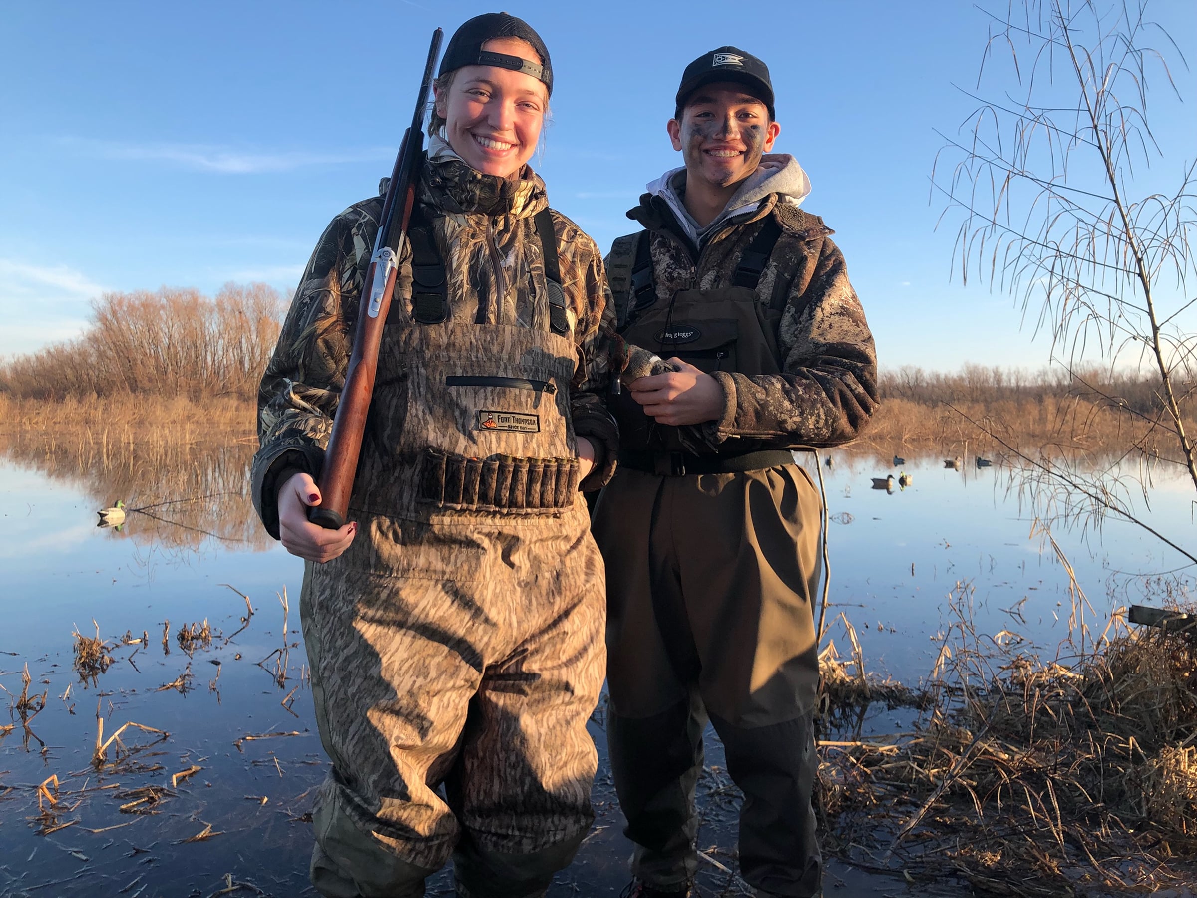
Youth waterfowl hunts provide a great opportunity for adult mentors to work with fledgling hunters, calling for them and helping retrieve harvested waterfowl.
Jan. 31, 2024
Jim Harris
Managing Editor Arkansas Wildlife Magazine
This marks the final waterfowl habitat report of the 2023-24 season. Regular hunting ended as of sunset Jan. 31. Youth 15 and under, veterans and active military may hunt Saturday, Feb. 3, from 30 minutes before sunrise to sunset throughout Arkansas. Regular bag limits and other regulations apply. The Light Goose Conservation Order (hunting of snow, blue and Ross’s geese with liberal regulations and no limits) runs Feb. 1-2 and Feb. 4-April 25.
- Southwest Arkansas
- Central Arkansas
- East-Central Arkansas
- Northwest Arkansas
- Northeast Arkansas
- Southeast Arkansas
Northeast Arkansas
Big Lake WMA
Map | Water Gauge | Weather Report
When the Ditch 81 extension gauge near Manila (upstream of the Big Lake north-end control structure) reads 17.5 feet, water is beginning to come over the north levee degrade on Big Lake WMA. When the Ditch 81 Extension gauge reads 18.0 feet or higher, the water level on the WMA will rise quickly and hunters should exercise caution while on the area. Be aware of underwater logs in boat runs and hangers in trees.
North Woods GTR
Habitat Type: Mast production
Water Level: Gauge reading at BoDoc is unavailable due to the gauge being underwater; target level is 235.5 feet; 100% flooded.
South Woods GTR
Habitat Type: Mast production
Water Level: Gauge reading at 7-Mile is 237.94 feet msl; target level is 234.5 feet; 100% flooded.
Simmons Field
Habitat: Native vegetation
Water Level: 100% coverage.
Dave Donaldson Black River WMA
Map | Water Gauge | Weather Report
Waterfowl hunters should be aware of hangers and submerged logs within the boat runs and GTRs. Please exercise caution when accessing the area. Please remember to keep boats off the levees so AGFC personnel can access the area. Boats blocking access will be moved. Unattended trailers are not to be left overnight in parking areas. As of Jan. 29, the Black River level at Corning was 12.13 feet and holding.
Upper Island GTR
Habitat Type: Mast crop within the GTRs
Water Level: Gauge is not accessible due to high water. Target level is 269.5 feet msl; 100% flooded.
Lower Island GTR
Habitat Type: Mast crop within the GTRs
Water Level: Gauge is not accessible due to high water. Target level is 268.0 feet; 100% flooded.
Upper Reyno GTR
Habitat Type: Mast crop within the GTRs
Water Level: Current level is 268.7 feet msl. Target level is 266.9 feet; 100% flooded.
Lower Reyno GTR
Habitat Type: Mast crop within the GTRs
Water Level: Current level is 268.65 feet msl. Target level is 266.3 feet; 100% flooded.
Winchester GTR
Habitat Type: Mast crop
Water Level: Current level is 265.5 feet msl. Target level is 263.7 feet; 100% flooded.
Earl Buss Bayou DeView WMA
Map | Water Gauge | Weather Report
Boaters should use caution while using the Thompson Tract boat lane.
South Oliver GTR
Habitat Type: Bottomland hardwoods
Water Level: Current gauge reading is 2.9 feet. 100% flooded.
Thompson Tract GTR
Habitat Type: Bottomland hardwoods
Water Level: Current gauge reading is 3.3 feet, 100% flooded.
Lake Hogue WRA
Habitat Type: Primarily deep open water
Water Level: Normal pool level
Shirey Bay Rainey Brake WMA
Map | Water Gauge | Weather Report
Waterfowl hunters should be aware of hangers and submerged logs within the boat runs and GTRs. Please exercise caution when accessing the area. In addition, hunters should allow safe passage when parking vehicles along roadsides. Vehicles blocking access will be moved.
Adam Brake GTR
Habitat Type: Mast production
Water Level: Water level is 239.9 feet msl with a target level of 240.0 feet. 100% flooded.
Rainey Brake GTR
Habitat Type: Mast production
Water Level: 100% flooded.
Eagle Pond GTR
Habitat Type: Mast production
Water Level: 100% flooded.
Phase III Moist-Soil Unit
Habitat Type: Japanese millet.
Water Level: 100% flooded.
Charles Crisp Moist-Soil Unit
Habitat Type: Japanese millet
Water Level: 100% flooded.
Ward Field Moist-Soil Unit
Habitat Type: Native vegetation
Water Level: 100% flooded.
River Field Moist-Soil Unit
Habitat Type: Japanese millet
Water Level: 100% flooded.
St. Francis Sunken Lands WMA
Map | Water Gauge | Weather Report
Hunt Area
Habitat Type: Bottomland hardwoods within the hunt area
Water Level: Water levels on St. Francis Sunken Lands for waterfowl season are dependent on flows from the St. Francis River. The target level for providing huntable timber is 212.0 feet msl at the Oak Donnick gauge. Current reading is 216.94 feet msl.
Snowden WRA
Habitat Type: Mixed grasses
Water Level: 20% flooded
Payneway WRA
Habitat Type: A, B, C and D pools have mixed smartweed and barnyard grasses. Moderate hardwoods within pools A, B and C as well.
Water Level: Pool A is at 10% coverage. Pool B is at 30%. Pool C is at 80%. Pool D is at 100%.
East-Central Arkansas
Henry Gray Hurricane Lake WMA
Map | Water Gauge | Weather Report
Hunters should call the Wildlife Hotline at 800-440-1477 for current road closures.
North Unit
Habitat Type: Bottomland timber
Water Level: The White River at Augusta as of Jan. 31 is at 31.09 feet (flood stage is 26 feet). The water level at Glaise Creek is at 194.52 feet msl and rising. All structures on the North GTR will remain open during the 2023-24 season.
South Unit
Habitat Type: Bottomland timber
Water Level: The White River at Augusta as of Jan. 31 is at 24.36 feet (flood stage is 26 feet). The water level at Glaise Creek is at 194.52 feet msl and rising. The South Unit now has no structures to close; water will flow freely throughout the unit.
Rex Hancock Black Swamp WMA
Map | Water Gauge | Weather Report
Hunters should call the Wildlife Hotline at 800-440-1477 for current road closures.
Gregory GTR
Habitat Type: Bottomland timber
Water Level: Cache River at Patterson was at 11.09 feet and steady on Jan. 31.
Wiville Moist-Soil Unit
Habitat Type: Native vegetation
Water Level: 90% flooded
Sheffield Nelson Dagmar WMA
Map | Water Gauge | Weather Report
Please visit www.agfc.com for maps, special regulations, permit application and draw dates. Hunters should call the Wildlife Hotline at 800-440-1477 for current road closures. The AGFC will not be putting boards in at Dagmar. Water coverage is dependent on river level.
Mud Slough GTR
Habitat Type: Bottomland timber
Water Level: 35% coverage
Apple Lake WRA (no hunting)
Habitat Type: Bottomland timber
Water Level: 50% coverage.
Conway George Waterfowl Unit A
Habitat Type: Native vegetation
Water Level: 90% coverage
Conway George Waterfowl Unit B
Habitat Type: Natural slough area with beneficial native wetland plants
Water Level: 90% coverage
Conway George Waterfowl Unit C
Habitat Type: Native vegetation
Water Level: 90% coverage
Dark Corner Waterfowl Unit 1
Habitat Type: Native vegetation
Water Level: 95%
Dark Corner Waterfowl Unit 2
Habitat Type: Native vegetation
Water Level: 90%
Dark Corner Waterfowl Unit 3
Habitat Type: Native vegetation
Water Level: 50%
Steve N. Wilson Raft Creek Bottoms WMA
Map | Water Gauge | Weather Report
Permits ARE required (via online application) on weekends, Tuesdays and Thursdays for the youth and mobility-impaired blinds and for the Magellan Tract. Visit agfc.com to apply for the online draw. There are no designated holes.
The White River gauge at Georgetown on Wednesday, Jan. 31, was 19.91 feet and rising.
Unit A
Habitat Type: Native vegetation
Water Level: 100% coverage.
Unit B
Habitat Type: Native vegetation
Water Level: 100%
Unit C
Habitat Type: Native vegetation
Water Level: 100%
Unit D
Habitat Type: Native vegetation
Water Level: 100%
Unit E
Habitat Type: Native vegetation
Water Level: 100%
Unit F (Youth Area)
Habitat Type: Native vegetation
Water Level: 100%
Unit G
Habitat Type: Native vegetation.
Water Level: 50%
Unit H (Mobility-impaired blind)
Habitat Type: Native vegetation
Water Level: 100%
Unit I
Habitat Type: Native vegetation.
Water Level: 50%
Unit J (Cypert Tract)
Habitat Type: Native vegetation
Water Level: 100%
Unit K (Cypert Tract)
Habitat Type: Native vegetation
Water Level: 35%
Unit L (Cypert Tract)
Habitat Type: Native vegetation
Water Level: 30%
Unit M (Magellan Tract)
Habitat Type: Native vegetation
Water Level: 100%

Central Arkansas
Bell Slough WMA
Map | Weather Report
Bell Slough GTR
Flooding of the Bell Slough GTR is rainfall dependent. Gates were lowered in the GTR water control structure Nov. 17.
Habitat Type: Bottomland hardwood/cypress-tupelo
Water Level: 100%
Palarm Creek WRA
Habitat Type: Native moist-soil vegetation
Water Level: 100%
Craig D. Campbell Lake Conway Reservoir
Map | Weather Report
Due to planned renovation work to Craig D. Campbell Lake Conway Reservoir, water levels remain 3-3.5 feet below normal pool on both Pierce and Dix creeks.
Cypress Bayou WMA
Map| Weather Report
Hunt Area
Habitat Type: Good mast crop
Water Level: 100% coverage.
Red Cut Slough Tract
Unit 1
Habitat Type: Native vegetation
Water Level: 30%
Unit 2
Habitat Type: Native vegetation
Water Level: 30%
Unit 3
Habitat Type: Native vegetation
Water Level: 100%
Unit 4
Habitat Type: Native vegetation
Water Level: 100%
Unit 5
Habitat Type: Native vegetation.
Water Level: 100%
Unit 6
Habitat Type: Open water reservoir
Water Level: 80%
Harris Brake WMA
Map | Weather Report
Upper GTR
Habitat Type: Good mast crop
Water Level: 100% coverage
Lower GTR
Habitat Type: Good mast crop.
Water Level: 15% coverage. Damage to one of the Lower GTRs water control structures is allowing water to drain from the Lower GTR and can’t currently be fixed. Sloughs and ditches within the Lower GTR unit will continue to hold water. However, the majority of the Lower GTR unit will stay drained due to the water control structure damage.
Holland Bottoms WMA
Map | Weather Report
Hunt Area
Habitat Type: Mast crop
Water Level: Recent rainfall has filled low-lying depressions and sloughs on the WMA.
Lake Pickthorne WRA (no hunting)
Habitat Type: Native vegetation and millet
Water Level: Both the East Unit and West Unit are 100% flooded.
Northwest Arkansas
Dardanelle WMA
Map | Weather Report
McKennon Bottoms (half-day hunting)
Habitat Type: Native moist soil
Water Level: 100% coverage
Potter’s Pothole Hartman Waterfowl Unit (half-day hunting)
Habitat Type: Japanese millet and native moist-soil vegetation
Water Level: 100% coverage
Ed Gordon Point Remove WMA
Map | Weather Report
All waterfowl impoundments are now at full pool.
Little Hole (Unit 1)
Habitat Type: Native moist-soil vegetation
Water Level: 100% flooded
Willow Island (Unit 2)
Habitat Type: Native moist-soil vegetation
Water Level: 100%
Red Gate (Unit 3)
Habitat Type: Native moist-soil vegetation
Water Level: 100%
Pig Trough (Units 4 and 5)
Habitat Type: Native moist-soil vegetation and Japanese millet
Water Level: 100%
Cedar Ridge (Unit 6)
Habitat Type: Native moist-soil vegetation
Water Level: 100%
Unit 7a
Habitat Type: Native moist-soil vegetation
Water Level: 100%
Unit 7b
Habitat Type: Native moist-soil vegetation
Water Level: 100%
Duck Trap (Units 8a, 8b and 8c)
8a
Habitat Type: Native moist-soil vegetation
Water Level: 100%
8b
Habitat Type: Native moist-soil vegetation
Water Level: 100%
8c
Habitat Type: Native moist-soil vegetation
Water Level: 100%
Unit 9
Habitat Type: Native moist-soil vegetation
Water Level: 100%
Controversy Corner (Unit 10)
Habitat Type: Native moist-soil vegetation and Japanese millet
Water Level: 100%
Remmel Marsh
Habitat Type: Native moist-soil vegetation
Water Level: 100%
Mud Pond (Unit 12)
Habitat Type: Native moist-soil vegetation
Water Level: 100%
Turkey Pond (Units 13a, 13b and 13c)
13a
Habitat Type: Native moist-soil vegetation
Water Level: 100%
13b
Habitat Type: Native moist-soil vegetation
Water Level: 100%
13c
Habitat Type: Native moist-soil vegetation
Water Level: 100%
Teeny Pond (Unit 14)
Habitat Type: Native moist-soil vegetation
Water Level: 100%
Salt Lick (Unit 15)
Habitat Type: Native moist-soil vegetation
Water Level: 100%
Bobby’s Pond (Unit 16)
Habitat Type: Native moist-soil vegetation
Water Level: 100%
Race Track (Unit 17)
Habitat Type: Native moist-soil vegetation
Water Level: 100%
Frog Bayou WMA
Map | Weather Report
Unit 1
Habitat Type: Japanese millet and moist soil vegetation
Water Level: 100%
Unit 2
Habitat Type: Native moist soil vegetation. Unit is rainfall dependent.
Water Level: 90%.
Unit 3
Habitat Type: Native moist soil vegetation
Water Level: 100%.
Unit 4
Habitat Type: Native moist soil vegetation
Water Level: 100%
Unit 5
Habitat Type: Native moist soil vegetation
Water Level: 100%
Unit 6
Habitat Type: Native moist soil vegetation
Water Level: 100%.
Unit 7
Habitat Type: Japanese millet and Native moist soil vegetation
Water Level: 100%
Galla Creek WMA
Map | Weather Report
Galla Creek
Habitat Type: Native moist soil vegetation and Japanese millet.
Water Level: 100%
Nimrod Lloyd Millwood WMA
Map | Weather Report
Nimrod GTR
Habitat Type: The red oak mast crop is moderate this year as well as the desirable native vegetation growth.
Water Level: 90% flooded. Flooding of the area is rainfall dependent.
Ozark Lake WMA/Dyer Lake Water Unit
Weather Report
Dyer Lake Cells
Unit 1 Dyer main cell
Habitat Type: Japanese millet
Water Level: 100% coverage for both units
Unit 2 Dyer Road Cell
Habitat Type: Native moist soil
Water Level: 100% coverage
Unit 3 South Cell
Habitat Type: Chiwapa and Japanese millet
Water Level: 25% coverage
Unit 4 West Cell (rainfall dependent)
Habitat Type: Fallow disked
Water Level: 0% coverage
Petit Jean River WMA
Map | Water Gauge | Weather Report
Sorehead Moist-Soil Unit
Habitat Type: Native vegetation
Water Level: 100%
Blacklands Moist-Soil Unit
Habitat Type: Native vegetation. The red oak trees within the unit produced a moderate mast crop this year. Pumping of this unit is dictated by river levels.
Water Level: 100%
Slaty Crossing Moist-Soil Unit
Habitat Type: Native vegetation
Water Level: 100%
Blacklands Duck Area
Habitat Type: Native vegetation
Water Level: 100%
Pullen Pond Marsh
Habitat Type: Native vegetation
Water Level: 100%. Flooding of the area is rainfall dependent.
Pond Creek GTR
Habitat Type: The red oak mast crop is moderate this year as well as the desirable native vegetation growth.
Water Level: 90%. Flooding of this area is rainfall dependent.
Slaty GTR
Habitat Type: The red oak mast crop is moderate this year as well as the desirable native vegetation growth.
Water Level: 30%. Flooding of this area is rainfall dependent.
Santa Fe GTR
Habitat Type: The red oak mast crop is moderate this year as well as the desirable native vegetation growth.
Water Level: 100%. Flooding of this area is rainfall dependent.
Southwest Arkansas
Dr. Lester Sitzes III Bois d’Arc WMA
Map | Weather Report
Bois d’Arc Lake WRA
Habitat Type: Closed to hunting.
Water Level: Normal
Red Slough WRA
Habitat Type: Closed to hunting.
Water Level: 80% coverage
GTR
Habitat Type: Bottomland timber
Water Level: 95%
Little Grassy
Habitat Type: Native moist-soil vegetation
Water Level: 80%
Millwood Lake
Map | Water Gauge | Weather Report
Habitat Type: Natural vegetation
Water Level: Millwood is at 260.20 feet msl as of Jan. 31; 1 feet above the normal pool of 259.2 feet msl.
Ozan WMA
Map | Weather Report
Flooding of all units is rainfall dependent.
Unit 1
Habitat Type: Native moist soil vegetation
Water Level: 70%
Unit 2
Habitat Type: Native moist-soil vegetation
Water Level: 40%
Unit 3
Habitat Type: Native moist-soil vegetation
Water Level: 30%
Unit 4
Habitat Type: Native moist-soil vegetation
Water Level: 50%
Unit 5
Habitat Type: Native moist-soil vegetation
Water Level: 20%
Sulphur River WMA
Map | Weather Report
Mercer Bayou
Habitat Type: Natural vegetation
Water Level: 100%
Henry Moore WRA
Habitat Type: Closed to hunting.
Water Level: 60%
Southeast Arkansas
Beryl Anthony Lower Ouachita WMA
Map | Weather Report
Water Level: No water
Cut-Off Creek WMA
Map | Weather Report
Hunt Area
Habitat Type: Bottomland hardwood habitat
Water Level: Water in lower areas and sloughs.
Pigeon Creek WRA
Habitat Type: Bottomland hardwood habitat
Water Level: Pumping as conditions allow.
Freddie Black Choctaw Island WMA Deer Research Area
Map | Water Gauge | Weather Report
Habitat Type: Bottomland hardwood habitat
Water Level: Flooding is river dependent. Click on the Water Gauge link above for current Mississippi River levels. Use extreme caution when boating in the river.
The Freddie Black Choctaw Island WMA West Unit allows weekend permit hunting for youths (one adult per youth hunter).
George H. Dunklin Jr. Bayou Meto WMA
Map | Water Gauge | Weather Report
The UGSG is reporting real-time water gauge readings at the headwater at each GTR within the George H. Dunklin Bayou Meto WMA. Click the Water Gauge link above for the WMA, and search for the particular GTR as noted.
NOTE: During the 2023-24 wintering period, all intentional flooding will be held at 178.5 feet msl, an elevation that will relieve stress on many trees such as red oaks that are showing signs of distress. Rain and increased flow into the WMA will allow water to rise above that level periodically. A good rule of thumb for comparing water levels to access into Bayou Meto: 176 feet msl – water breaking into sloughs and lower ditches; 177-177.5 feet msl – water beginning to break out of sloughs and lower ditches; 178 feet msl – water in most sloughs and ditches and entering into lower elevations in woods; 178.5 feet msl – most ditches and sloughs deep enough to boat and most boat ramps become serviceable; 179 feet msl or above – water expands to the higher elevations.
Upper Vallier GTR
Habitat Type: Bottomland hardwood habitat
Water Level: 180.28 feet msl and steady as of Jan. 31. See Gauge Link (Upper Vallier Headwater) for updated info.
Lower Vallier GTR
Habitat Type: Bottomland hardwood habitat
Water Level: 179.07 feet msl and falling as of Jan. 31. See Gauge Link (Lower Vallier Headwater) for updated info.
Government Cypress GTR
Habitat Type: Bottomland hardwood habitat
Water Level: 180.37 feet msl and falling as of Jan. 31. See Gauge Link (Government Cypress Headwater) for updated info.
Buckingham Flats GTR
Habitat Type: Bottomland hardwood habitat
Water Level: 177.88 feet and steady as of Jan. 31. See Gauge Link (Buckingham Flats Headwater) for updated info.
Temple Island GTR
Habitat Type: Bottomland hardwood habitat
Water Level: 184.52 feet msl and falling as of Jan. 31. See Gauge Link (Temple Island Headwater) for updated info.
Canon Brake
Habitat Type: Bottomland hardwood
Water Level: 178.16 feet msl and steady as of Jan. 31. See Gauge Link (Canon Brake Headwater) for updated info.
Halowell WRA
Habitat Type: Moist soil
Water Level: Staggered flooding of units
Wrape Plantation WRA
Habitat Type: Moist soil
Water Level: Staggered flooding of units
Seven Devils WMA
Map | Weather Report
Hunt Area
Habitat Type: Bottomland hardwood habitat
Water Level: Huntable water is available.
Trusten Holder WMA
Map | Water Gauge | Weather Report
Habitat Type: Bottomland hardwood habitat
Water Level: Flooding is river dependent. Click on the Water Gauge link above for current Arkansas River levels.
Recent News
Arkansas Wildlife Weekly Fishing Report
Jul. 23, 2026

Greenwood Native Hampton Receives Monty Carmikle Award
Jul. 22, 2026
Subscribe to Our Weekly Newsletter E-mails
Don’t miss another issue. Sign up now to receive the AGFC Wildlife Weekly Newsletter in your mailbox every Wednesday afternoon (Waterfowl Reports are published weekly during waterfowl season and periodically outside the season). Fishing Reports arrive on Thursdays. Fill in the following fields and hit submit. Thanks, and welcome!