Arkansas Wildlife Waterfowl Report
BY Jim Harris
ON 12-01-2021
Dec. 1, 2021
Jim Harris
Managing Editor Arkansas Wildlife Magazine
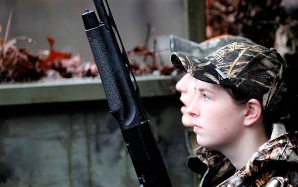
Take a Break: Saturday Belongs to Youth, Veterans, Active Military
LITTLE ROCK – Ducks are getting an 11-day break from pursuit by the regular waterfowlers, but this Saturday belongs to youth hunters, military veterans and active military in an annual special hunt held during the first season break.
Thanks to special rules enacted by the U.S. Fish and Wildlife Service and the Arkansas Game and Fish Commission, duck hunters 15 and younger, as well as active-duty military personnel and veterans, may hunt waterfowl during Arkansas’s third annual Special Youth and Active Duty Military and Veteran Waterfowl Hunt on Saturday. They also have their own day for hunting after the 60-day regular season closes, on Saturday, Feb. 5.
Youths have had this special hunt for 20 years, and the day was modified during the 2019-20 waterfowl hunting season to include veterans and active-duty military as a show of gratitude for their service to the citizens of the United States.
AGFC Director Austin Booth said the hunt holds a special place for him. Booth, who served as captain in the United States Marine Corps for eight years, including a deployment to Afghanistan, was Chief of Staff and Chief Financial Officer at the Arkansas Department of Veterans Affairs before taking up the reins as the director of the AGFC.
“Having a day specifically reserved for young Arkansans, active-duty personnel and veterans to duck hunt is a wonderful occasion this state should be proud of,” Booth said. “Passing down the memories, trials, and rewards of military service from one generation to the next is just as important as passing down a love for duck hunting. This special day provides a special opportunity for both.”
Regular duck hunting rules are in place, though the hunters may also hunting the AGFC’s wildlife management areas managed for waterfowl all day, rather than having the cease hunting and be off the hunting areas by 1 p.m.
Also (and something for veterans, active military and youths to keep in mind for the second hunt in February), the Arkansas WRICE program fields were made available for the Saturday hunt, as well as permits that are required in some of the WMAs, such as Steve N. Wilson Raft Creek Bottoms WMA and Sheffield Nelson Dagmar WMA.
Youths and veterans may have additional people with them during their hunt as a mentor or observer. Those people may call, video the hunt, or work a dog to retrieve ducks, but they may not carry a firearm or assist with shooting. Shooting hours and bag limits are the same as regular duck and goose seasons. Hunting time statewide is 30 minutes before sunrise to sunset.
This first hunt is falling at a time when the state is enduring mostly dry conditions, which has limited the habitat available and therefore the ducks stopping over in Arkansas during their migration. The hunts are split into two days at different times of year, rather than held over an entire weekend, to increase the chances of it coinciding with good weather conditions and duck abundance. In some years, early water and cold weather combine to create good duck hunting in December. During other years, the water and ducks do not seem to arrive in great numbers until later in the season. Two hunts offer two chances to catch the right combination of weather and birds.
“This hunt is a natural time for Arkansans to do their part to recruit new, young waterfowlers or get a servicemember involved, but it doesn’t stop there,” Booth said. “The ultimate goal isn’t for us to do this annually; it’s to bring young Arkansas, active-duty servicemembers and veterans alongside us throughout the entire year to embrace the hunting lifestyle. That’s my challenge to each of us, both as a veteran and as your Game and Fish director.”
* * *
Just a reminder to hunters able to participate Saturday: Daily bag limits are unchanged from last year. Regulations allow for 6 ducks, which may include no more than 4 mallards (2 hens), 1 scaup, 3 wood ducks, 1 pintail, 2 redheads, 2 canvasbacks, 2 black ducks, 1 mottled duck. If not listed, up to 6 ducks of a species (such as teal) may be taken. The coot daily bag limit is 15 and the merganser daily limit is 5, which may include no more than 2 hooded mergansers. The second split will open Saturday, Dec. 11 and run until Dec. 23. The final section of the season runs Dec. 26-Jan. 31.
* * *
As for those waterfowlers who will be anxious to return to hunting efforts beginning Saturday, Dec. 11, with the resumption of the season, the period from 3 p.m. Thursday until midnight Sunday this week is the time to make plans and apply for permits online draw opportunities are available through the Arkansas Game and Fish Commission. Permit hunts are offered on Steve N. Wilson Raft Creek Bottoms WMA, the Red Cut Slough tract at Cypress Bayou WMA (though, without water, those permits are suspended until there is huntable water), the Conway George tract at Sheffield Nelson Dagmar WMA and Freddie Black Choctaw Island West Unit WMA. And AGFC has up to 45 privately owned flooded rice fields available to hunt by permit through its special duck hunting application process. Again, with the dry conditions around the state, some leased fields are still not available, though most owners are attempting to flood their fields this year and many have upgraded their blinds for a better hunting experience. Visit https://www.agfc.com/en/hunting/migratory-birds/waterfowl/special-waterfowl-permit-hunts to learn more about these special duck-hunting opportunities and to apply.
* * *
Ducks are being observed moving into various regions of Arkansas, according to observers.
Eley Talley, assistant regional supervisor in southwest Arkansas, says that although the water levels have not shown much change, “we do seem to have gotten a push of ducks over the weekend.”
Kent Williams, a fishing guide in eastern Arkansas who reports to us from Horseshoe Lake, has been trying to hunt ducks of late. He says, “We hunt In Phillips County. DRY is the only word I have. We have some permanent water but it is not enough. We have killed few ducks and what ducks we are seeing are headed further south.”
In northeast Arkansas, good numbers of ducks have been observed flying through, but mostly they’ve been high.
Water is good in Dave Donaldson Black River WMA, though the river was dropping some earlier this week and a couple of areas that saw full water coverage a week ago were less full as this week began. Shirey Bay Rainey Brake WMA has picked up some in water coverage, but it’s still far from fully flooded.
Only the youth blind and mobility-impaired blind at Steve N. Wilson Raft Creek Bottoms WMA have 100% water, though other areas are inching their way up.
In the Waterfowl Report, when the water level is noted as being 100% flooded, this means the area has full coverage. It does not mean that water is HIGH in the area, only that there is water covering the entire GTR or moist-soil unit listed.
There is still no water in Red Cut Slough of Cypress Bayou WMA in central Arkansas; therefore, there hasn’t been any permit draw held for that area since the season began.
Due to lack of rainfall, conditions at Ed Gordon Point Remove WMA remain considerably dry, according to Region Superintendent Alex Zachary. Pumping of waterfowl impoundments began on Oct. 27 and will continue as long as water levels in Point Remove Creek allow, and some preferred hunting spots are beginning to get coverage. He says that duck use and hunter success on the WMA have been generally poor due to dry conditions.
Pumping is boosting the coverage in Frog Bayou WMA in western Arkansas. Cut-Off Creek and Bayou Meto remain dry in southeast Arkansas. Staggered flooding of units in the rest areas of Halowell and Wrape Plantation continues.
Northeast Arkansas
Big Lake WMA
Map | Water Gauge | Weather Report
When the Ditch 81 extension gauge near Manila (upstream of the Big Lake north-end control structure) reads 17.5 feet, water is beginning to come over the north levee degrade on Big Lake WMA. When the Ditch 81 Extension gauge reads 18.0 feet or higher, the water level on the WMA will rise quickly and hunters should exercise caution while on the area. Be aware of underwater logs in boat runs and hangers in trees.
North Woods GTR
Habitat: Mast production is good.
Water Level: Gauge reading at BoDoc on Monday was 234.0 feet msl; target level is 235.5 feet with 20% now flooded.
South Woods GTR
Habitat: Mast production is fair.
Water Level: Reading at the 7-Mile gauge on Monday was 233.3 feet msl; target level is 234.5 feet with 40% now flooded, lateral ditches and some borrow pits are flooded.
Simmons Field
Habitat: Good production of millet and sedge. Native production is good in the north, middle and south fields.
Water Level: 5% coverage.
Reports of a few ducks moving across the area, but flying high.
Dave Donaldson Black River WMA
Map | Water Gauge | Weather Report
Waterfowl hunters should be aware of hangers and submerged logs within the boat runs and GTRs. Please exercise caution when accessing the area. Please remember to keep boats off the levees so AGFC personnel can access the area. Boats blocking access will be moved. Unattended trailers are not to be left overnight on parking areas. River level is 2.92 feet and falling.
Upper Island GTR
Habitat: Mast crop is moderate within the GTRs.
Water Level: Current level is 269.55 feet msl. Target level is 269.5; 100% flooded.
Lower Island GTR
Habitat: Mast crop is moderate within the GTRs.
Water Level: Current level is 268.6 feet msl. Target level is 268.0; 100% flooded.
Upper Reyno GTR
Habitat: Mast crop is moderate within the GTRs.
Water Level: Current level is 266.95 feet msl. Target level is 266.9; 100% flooded.
Lower Reyno GTR
Habitat: Mast crop is moderate within the GTRs.
Water Level: Current level is 266.1 msl. Target level is 266.3; 90% flooded.
Winchester GTR
Habitat: Mast crop is moderate within the GTRs.
Water Level: Current level is 263.2 feet msl. Target level is 263.7; 70% flooded.
Earl Buss Bayou DeView WMA
Map | Water Gauge | Weather Report
Boaters should use caution while using the Thompson Tract boat run.
South Oliver GTR
Habitat: Mast production is good.
Water Level: 5% flooded
Thompson Tract GTR
Habitat: Mast production is good.
Water Level: 0% flooded. The Thompson Tract GTR will be allowed to rise and fall naturally without the gates being operated beginning with this season. This action is an effort to help the next generation of forest.
Lake Hogue WRA
Habitat: Primarily deep open water habitat.
Water Level: Normal pool level.
Shirey Bay Rainey Brake WMA
Map | Water Gauge | Weather Report
Waterfowl hunters should be aware of hangers and submerged logs within the boat runs and GTRs. Please exercise caution when accessing the area. In addition, hunters should allow safe passage when parking vehicles along roadsides. Vehicles blocking access will be moved.
Adam Brake GTR
Habitat: Mast production is good.
Water Level: Water level is 238.0 feet msl with a target level of 240.0 feet msl; 40% flooded.
Rainey Brake GTR
Habitat: Mast production is good.
Water Level: 40% flooded.
Eagle Pond GTR
Habitat: Mast production is good.
Water Level: 20% flooded.
Phase III Moist-Soil Unit
Habitat: Good wetland-type vegetation.
Water Level: 30% flooded.
Charles Crisp Moist-Soil Unit
Habitat: Good wetland-type vegetation.
Water Level: 30% flooded.
Ward Field Moist-Soil Unit
Habitat: Good wetland-type vegetation.
Water Level: 60% flooded.
River Field Moist-Soil Unit
Habitat: Good wetland-type vegetation.
Water Level: 60% flooded.
St. Francis Sunken Lands WMA
Map | Water Gauge | Weather Report
Hunt Area
Habitat: Good mast production within the hunt area.
Water Level: Water levels on St. Francis Sunken Lands for waterfowl season are dependent on flows from the St. Francis River. The target level for providing huntable timber is 212.0 feet msl at the Oak Donnick gauge. As of Nov. 29, the reading was 212.51 feet msl.
Snowden WRA
Habitat: Mixed grasses.
Water Level: 2% flooded, mostly in the low-lying areas due to rain.
Payneway WRA
Habitat: A, B, C and D pools have mixed smartweed and barnyard grasses. Moderate mast is available within pools A, B and C as well.
Water Level: Pool A is at 0% coverage. Pool B is at 0%. Pool C is at 0%. Pool D is at 0%.
East-Central Arkansas
Henry Gray Hurricane Lake WMA
Map | Water Gauge | Weather Report
Hunters should call the Wildlife Hotline at 800-440-1477 for current road closures.
North Unit
Habitat: Good mast crop.
Water Level: 0%. All structures throughout the WMA will remain open during the 2021-22 season.
South Unit
Habitat: Fair mast crop.
Water Level: 0%. All structures on the South Unit are open.
Rex Hancock Black Swamp WMA
Map | Water Gauge | Weather Report
Hunters should call the Wildlife Hotline at 800-440-1477 for current road closures.
Gregory GTR
Habitat: Good mast crop.
Water Level: 0% (the Cache River level is 3.7 feet and rising on the Patterson gauge).
Wyeville Moist-Soil Unit
Habitat: Good stand of millet and native vegetation.
Water Level: 10% coverage.
Sheffield Nelson Dagmar WMA
Map | Water Gauge | Weather Report
The Conway George units are currently available for hunting by applying for online permits. Youths may apply for Saturday and Sunday hunts, with one adult hunter allowed per one youth, up to four hunters in the blind. All ages may apply for Wednesday hunts. Please visit www.agfc.com for maps, special regulations, permit application and draw dates. Hunters should call the Wildlife Hotline at 800-440-1477 for current road closures. The AGFC will not be putting boards in at Dagmar. Water coverage is dependent on river level.
Mud Slough GTR
Habitat: Good mast crop.
Water Level: 0% coverage.
Apple Lake WRA (no hunting)
Habitat: Good mast crop.
Water Level: 20%.
Conway George Waterfowl Unit A
Habitat: Good stand of millet and native vegetation.
Water Level: 100%
Conway George Waterfowl Unit B
Habitat: Natural slough area with beneficial native wetland plants.
Water Level: 100%
Conway George Waterfowl Unit C
Habitat: Good stand of millet and native vegetation.
Water Level: 0%
Steve N. Wilson Raft Creek Bottoms WMA
Hunting in Raft Creek Bottoms WMA requires participation on the online draw a week before the following weekend’s hunt. There is no online draw on Tuesdays and Thursdays, and permits are available at the boat accesses. Permits ARE required (via online application) on weekends, Tuesdays and Thursdays for the youth and mobility-impaired blinds and for the Magellan Tract. Visit agfc.com to apply for the online draw. There will be no designated holes this season.
Map | Water Gauge | Weather Report
Unit A
Habitat: Excellent stand of native vegetation.
Water Level: 90% coverage.
Unit B
Habitat: Excellent stand of millet and native vegetation.
Water Level: 30%
Unit C
Habitat: Good stand of native vegetation.
Water Level: 85%
Unit D
Habitat: Good stand of native vegetation.
Water Level: 85%
Unit E
Habitat: Excellent stand of millet and native vegetation.
Water Level: 85%
Unit F (Youth Area)
Habitat: Good stand of millet and native vegetation.
Water Level: 100%
Unit G
Habitat: Fair stand of millet and native vegetation.
Water Level: 0%
Unit H (Mobility-impaired blind)
Habitat: Excellent stand of native vegetation.
Water Level: 100%
Unit I
Habitat: Habitat conditions are poor.
Water Level: 0%
Unit J (Cypert Tract)
Habitat: Excellent stand of native vegetation.
Water Level: 80%
Unit K (Cypert Tract)
Habitat: Excellent stand of native vegetation.
Water Level: 5%
Unit L (Cypert Tract)
Habitat: Fair stand of native vegetation.
Water Level: 0%
Unit M (Magellan Tract)
Habitat: Fair stand of native vegetation.
Water Level: 35%
Central Arkansas
Bell Slough WMA
Map | Weather Report
The Bell Slough GTR is primarily rainfall dependent with the exception of a limited amount of water that the AGFC can back in and catch from Palarm Creek.
Bell Slough GTR
Habitat: Poor mast crop.
Water Level: 30%.
Palarm Creek WRA
Habitat: Fair stand of planted millet.
Water Level: 30%
Craig D. Campbell Lake Conway Reservoir
Map | Weather Report
Habitat and water levels are normal on both Pierce and Dix creeks.
Cypress Bayou WMA
Hunt Area
Habitat:
Good mast crop.
Water Level: 0% coverage.
Red Cut Slough Tract
Unit 1
Habitat:
Habitat conditions are poor.
Water Level: 0%
Unit 2
Habitat:
Excellent stand of millet and native vegatation
Water Level: 0%
Unit 3
Habitat:
Good stand of millet and native vegatation
Water Level: 0%
Unit 4
Habitat: Good stand of millet and native vegetation.
Water Level: 0%
Unit 5
Habitat:
Good stand of native vegetation.
Water Level: 0%
Unit 6
Habitat:
Good stand of native vegetation.
Water Level: 0%
Harris Brake WMA
Upper GTR
Habitat: Below average mast crop this year.
Water Level: 80%.coverage,
Lower GTR
Habitat: Below average mast crop.
Water Level: 70% coverage. Note: The water control structures on both the Lower and Upper GTRs were closed on Monday, Nov. 15. The Harris Brake Lake valve was opened on Nov. 15 to begin supplemental flooding of both the Lower and Upper GTRs. Water is now over Steamboat Road.
Holland Bottoms WMA
Hunt Area
Habitat: Good mast crop.
Water Level: 0% coverage.
Lake Pickthorne WRA (no hunting)
Habitat: Excellent crop of native vegetation and millet.
Water Level: East cell is 0%, West cell is 95%. Staggered flooding began Nov. 9.
Northwest Arkansas
Dardanelle WMA
McKennon Bottoms (half-day hunting)
Habitat: Good stand of native vegetation.
Water Level: 100% coverage
Potter’s Pothole Hartman Waterfowl Unit (half-day hunting)
Habitat: West cell has a good stand of Japanese millet. East Cekk has a poor stand of Japanese millet.
Water Level: 100% coverage
Ed Gordon Point Remove WMA
Due to lack of rainfall, conditions at Ed Gordon Point Remove WMA remain considerably dry. Pumping of waterfowl impoundments began on Oct. 27 and will continue as long as water levels in Point Remove Creek allow.
Duck use and hunter success on the WMA have been generally poor due to dry conditions.
Little Hole (Unit 1)
Habitat: Japanese millet.
Water Level: 80% flooded.
Willow Island (Unit 2)
Habitat: Japanese millet and natural vegetation.
Water Level: 30%
Red Gate (Unit 3)
Habitat: Natural vegetation
Water Level: 0%
Pig Trough (Units 4 and 5)
Habitat: Natural vegetation and Japanese millet.
Water Level: 40%
Cedar Ridge (Unit 6)
Habitat: Natural vegetation.
Water Level: 60%
Unit 7a
Habitat: Natural vegetation.
Water Level: 60%
Unit 7b
Habitat: Japanese millet and natural vegetation.
Water Level: 0%
Duck Trap (Units 8a, 8b and 8c)
8a
Habitat: Natural vegetation.
Water Level: 0%
8b
Habitat: Natural vegetation.
Water Level: 50%
8c
Habitat: Natural vegetation.
Water Level: 25%
Unit 9
Habitat: Japanese millet and natural vegetation.
Water Level: 10%
Controversy Corner (Unit 10)
Habitat: Natural vegetation.
Water Level: 70%
Remmel Marsh
Habitat: Natural vegetation and Japanese millet.
Water Level: 50%
Mud Pond (Unit 12)
Habitat: Natural vegetation and Japanese millet.
Water Level: 90%
Turkey Pond (Units 13a, 13b and 13c)
13a
Habitat: Natural vegetation.
Water Level: 50%
13b
Habitat: Natural vegetation.
Water Level: 0%
13c
Habitat: Natural vegetation.
Water Level: 0%
Teeny Pond (Unit 14)
Habitat: Natural vegetation.
Water Level: 0%
Salt Lick (Unit 15)
Habitat: Natural vegetation.
Water Level: 50%
Bobby’s Pond (Unit 16)
Habitat: Natural vegetation.
Water Level: 70%
Race Track (Unit 17)
Habitat: Natural vegetation.
Water Level: 100%
Frog Bayou WMA (half-day hunting)
Unit 1
Habitat: Good stand of moist-soil vegetation.
Water Level: 100% coverage
Unit 2
Habitat: Poor stand of moist-soil vegetation.
Water Level: Less than 25% flooded (rainfall dependent)
Unit 3
Habitat: Good stand of moist-soil vegetation and planted millet.
Water Level: 100%
Unit 4
Habitat: Good stand of moistl-soil vegetation and planted millet
Water Level: 100%
Unit 5
Habitat: Good stand of moist-soil vegetation on the upper end, lower end has been fallow-disked.
Water Level: 90% and currently pumping.
Unit 6
Habitat: Good stand of moist-soil vegetation.
Water Level: 50% and currently pumping.
Unit 7
Habitat: Good stand of moist-soil vegetation.
Water Level: 50% and currently pumping.
Galla Creek WMA
Galla Creek GTR
Habitat: Good stands of native vegetation, including a mixture of barnyard grass, annual smartweeds and sprangletop.
Water Level: 40% flooded. Staged flooding of the impoundment began on Nov. 15.
Nimrod Lloyd Millwood WMA
Nimrod GTR
Habitat: The red oak mast crop is poor this year but the desirable native vegetation growth is better than in previous years. Due to abnormally dry conditions, this area is not expected to fill up as fast as in previous years. The water-control structures were closed on Nov. 17. This area is rainfall dependent to flood.
Water Level: 10% flooded.
Ozark Lake WMA/Dyer Lake Water Unit
Dyer Lake Cells (half-day hunting)
Units 1 and 2
Habitat: Good stand of moist-soil vegetation and planted millet
Water Level: 100% coverage for both units
Unit 3 South Cell
Habitat: Good stand of moist-soil vegetation and volunteer millet
Water Level: 10% coverage
Unit 4 West Cell (rainfall dependent)
|Habitat: Poor stand of moist-soil vegetation
Dyer West Cell: Less than 25% coverage
Petit Jean River WMA
Map | Water Gauge | Weather Report
Sorehead Moist-Soil Unit
Habitat: Due to ongoing waterfowl habitat enhancement projects, this unit was not able to grow any food this year. Work is still ongoing as long as this area stays dry. The Kingfisher Lake water-control structure valve was opened on Nov. 17 to help flood this area.
Water Level: 10%
Blacklands Moist-Soil Unit
Habitat: This unit this year contains one of the best stands of desirable native vegetation in recent years. The wooded areas inside the unit produced a poor red oak mast crop this year. Due to abnormally dry conditions and low river levels, this area is not expected to fill up as fast as in previous years. The river level is still too low to properly pump.
Water Level: 0%.
Slaty Crossing Moist-Soil Unit
Habitat: Due to ongoing waterfowl habitat enhancement projects, this unit was not able to grow a desirable native vegetation crop this year. The area was seeded with millet after the project was completed. The area yielded a great stand of planted millet. Due to abnormally dry conditions and low river levels, this area is not expected to fill up as fast as in previous years. The pump was started on Nov. 17 but will not be run continuously this year due to the lack of adequate water in the river.
Water Level: 25%
Blacklands Duck Area
Habitat: The wooded sections of this area produced a poor red oak mast crop this year. This area also contains a mix of moderate to great stands of desirable native vegetation mixed throughout. The Kingfisher Lake water-control structure valve was opened on Nov. 17 to help flood this area.
Water Level: 50%
Pullen Pond Marsh
Habitat: Due to ongoing waterfowl habitat enhancement projects, parts of the central section of this area is bare ground. Most of the area has amazing stands of desirable native vegetation. The desirable native vegetation has started to become more and more prevalent with each year of ongoing management work. Work is still ongoing until the area becomes too wet to work. This area is rainfall dependent to flood.
Water Level: 0%.
Pond Creek GTR
Habitat: This area produced a poor red oak mast crop this year with good stands of desirable native vegetation in the open lands within this area. Due to abnormally dry conditions, this area is not expected to fill up as fast as in previous years. The water-control structures were closed on Nov. 16. This area is rainfall dependent to flood.
Water Level: 0%. Flooding of this area is rainfall dependent.
Slaty GTR
Habitat: This area produced a poor red oak mast crop this year with good stands of desirable native vegetation in the open lands within this area. Due to abnormally dry conditions, this area is not expected to fill up as fast as in previous years. The water-control structure was closed on Nov. 16.
Water Level: 0%. Flooding of this area is rainfall dependent.
Santa Fe GTR
Habitat: This area produced a lpoor red oak mast crop this year with good stands of desirable native vegetation in the open lands within this area. Due to abnormally dry conditions, this area is not expected to fill up as fast as in previous years. The water-control structures were closed on Nov. 16.
Water Level: 0%. Flooding of this area is rainfall dependent.
Southwest Arkansas
Dr. Lester Sitzes III Bois d’Arc WMA
Bois d’Arc Lake WRA
Habitat: Closed to hunting.
Water Level: Normal
Red Slough WRA
Habitat: Closed to hunting.
Water Level: 25% coverage.
GTR
Habitat: Good mast production.
Water Level: 0%. Water control structurs closed Dec. 1.
Little Grassy
Habitat: Good
Water Level: 20%
Millwood Lake
Map | Water Gauge | Weather Report
Habitat: Habitat conditions are good.
Water Level: Millwood is at 259.1 feet msl as of Nov. 30.
Ozan WMA
Flooding of all units is rainfall dependent.
Unit 1
Habitat: Good
Water Level: 0%
Unit 2
Habitat: Good
Water Level: 0%
Unit 3
Habitat: Good
Water Level: Very little huntable water.
Unit 4
Habitat: Good
Water Level: 0%
Unit 5
Habitat: Good
Water Level: 0%
Sulphur River WMA
Mercer Bayou
Habitat: Fair
Water Level: 0%
Henry Moore WRA
Habitat: Closed to hunting.
Water Level: 30%
Southeast Arkansas
Beryl Anthony Lower Ouachita WMA
Map | Weather Report
Water Level: No duck-hunting water. Water is available in the oxbow lakes located in the WMA.
Cut-Off Creek WMA
Hunt Area
Habitat: Habitat conditions are good.
Water Level: No water.
Pigeon Creek WRA
Habitat: Habitat conditions are good.
Water Level: No water.
Freddie Black Choctaw Island WMA Deer Research Area
Map | Water Gauge | Weather Report
Habitat conditions are good. Flooding is river dependent. Click on the Water Gauge link above for current Mississippi River levels. Use extreme caution when boating in river.
The Freddie Black Choctaw Island WMA West Unit allows weekend permit hunting for youths (one adult per youth hunter); on Wednesdays, all ages may apply for a permit to hunt the blinds in the West Unit. Currently, the area is dry and there have been no online draws for the West Unit.
George H. Dunklin Jr. Bayou Meto WMA
Map | Water Gauge | Weather Report
The UGSG is reporting real-time water gauge readings at the headwater at each GTR within the George H. Dunklin Bayou Meto WMA. Click the Water Gauge link above for the WMA, and search for the particular GTR as noted.
During the 2021-22 wintering period, all intentional flooding will be held at 179 feet msl, an elevation that will relieve stress on many of trees such as red oaks that are showing signs of distressed. Rain and increased flow into the WMA will allow water to rise above that level periodically, but artificial flooding will be stopped at the 179 feet msl mark. A good rule of thumb for comparing water levels to access into Bayou Meto: 176 feet msl – water breaking into sloughs and lower ditches; 177-177.5 feet msl – water beginning to break out of sloughs and lower ditches; 178 feet msl – water in most sloughs and ditches and entering into lower elevations in woods; 178.5 feet msl – most ditches and sloughs deep enough to boat and most boat ramps become serviceable; 179 feet msl or above – good duck hunting waters.
Upper Vallier GTR
Habitat: Good
Water Level: See Gauge Link (Upper Vallier Headwater)
Lower Vallier GTR
Habitat: Good
Water Level: See Gauge Link (Lower Vallier Headwater).
Government Cypress GTR
Habitat: Good
Water Level: See Gauge Link (Government Cypress Headwater)
Buckingham Flats GTR
Habitat: Good
Water Level: No water. See Gauge Link (Buckingham Flats Headwater). NOTE: Water is too low for pumping at this time.
Temple Island GTR
Habitat: Good
Water Level: No water. See Gauge Link (Temple Island Headwater). NOTE: Water is too low for pumping at this time.
Canon Brake
Habitat: Good
Water Level: See Gauge Link (Canon Brake Headwater).
Halowell WRA
Habitat: Excellent
Water Level: Staggered flooding of units.
Wrape Plantation WRA
Habitat: Excellent
Water Level: Staggered flooding of units.
Seven Devils WMA
Hunt Area
Habitat: Habitat conditions are good.
Water Level: No water.
Trusten Holder WMA
Map | Water Gauge | Weather Report
Habitat conditions are good. Flooding is river dependent. Click on the Water Gauge link above for current Arkansas River levels.
Recent News

Arkansas Wildlife Weekly Fishing Report
Jul. 10, 2025
Lonoke aquaculturist named to AGFC
Jul. 10, 2025
Subscribe to Our Weekly Newsletter E-mails
Don’t miss another issue. Sign up now to receive the AGFC Wildlife Weekly Newsletter in your mailbox every Wednesday afternoon (Waterfowl Reports are published weekly during waterfowl season and periodically outside the season). Fishing Reports arrive on Thursdays. Fill in the following fields and hit submit. Thanks, and welcome!