Arkansas Wildlife Waterfowl Report
BY Jim Harris
ON 02-03-2021
Feb. 3, 2021
Jim Harris
Managing Editor Arkansas Wildlife Magazine
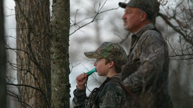
Second Youth and Military Special Hunt Puts a Wrap on Waterfowl Season
LITTLE ROCK – This Saturday will present another opportunity this season for adults to help mentor young hunters in the fields or the flooded timber areas in pursuit of waterfowl.
The second of two youth and veteran waterfowl hunts will give a few hunters one more shot at Arkansas’s premier game species before the waterfowl season finally wraps for 2020-21. The Special Active Duty Military and Veteran Waterfowl Hunt will again take place alongside Arkansas’s Special Youth Waterfowl Hunt on Feb. 6 from 30 minutes before sunrise until sunset statewide.
The state’s wildlife management areas are open all day (see the Waterfowl Report by clicking the green button below), while hunters will also be enjoying private land hunting. A handful of Arkansas Waterfowl Rice Incentive Conservation Enhancement fields were obtained for permits as well; all permits were assigned by Jan. 24 for this weekend and must be in hand to use on any of the AGFC’s permitted locations.
Duck and goose hunters 15 and younger may hunt during this special season, which was created nearly 20 years ago by the Arkansas Game and Fish Commission after this option was offered by the U.S. Fish and Wildlife Service. It was modified last year to allow active-duty military personnel and veterans to hunt as well in a show of gratitude for their service.
Youths and veterans may have additional people with them during their hunt as a mentor or observer. Those people may call, video the hunt, or work a dog to retrieve ducks, but they may not carry a firearm or assist with shooting. Shooting hours and bag limits are the same as regular duck and goose seasons.
Also, shell restrictions on WMAs for the regular 60-day hunting season are lifted during these special hunts.
“This is an excellent opportunity for mentors to instill those unwritten rules of waterfowling to new hunters,” Luke Naylor, AGFC waterfowl program coordinator, said “It’s a great way to show them that waterfowl hunting isn’t about racing in the woods for a YouTube video or seeing who can take a picture of the biggest pile of birds; it’s about sharing the experience.”
While the spirit of the special hunt is to allow for more time between a mentor and youth hunter, youths who have completed a hunter education course may hunt on their own if their parent or legal guardian feels comfortable allowing them to do so. Youths who have not completed a hunter education course must be accompanied by a mentor who is 21 years or older.
* * *
Duck season may be over, as well as hunting for greater white-fronted geese, but there are plenty of opportunities for hunters in pursuit of lesser geese, the snows, blues and Ross’s geese that are still populating the Arkansas fields.The only day not available for the Conservation Order between now and April 25 is this Saturday, Feb. 6, which is dedicated to the special statewide hunt only open to Youth, Veterans and Active Military. Those hunters are eligible to take geese Saturday along with ducks following regular guidelines for waterfowl season.
As for the Light Goose Conservation Order, special regulations include no daily bag limit and the allowed use of electronic calling devices, among other rules that would normally be prohibited during regular waterfowl season. Check the AGFC’s Waterfowl Guide Book for any other particulars in hunting during the Light Goose Conservation Order.
A reminder for those in the goose fields, however: The season for greater white-fronted geese (specklebellies) ended with ducks on Jan. 31.
Though the aerial surveys conducted by AGFC staff are designed for ducks and not geared toward counting geese, observers did estimate about a half-million light geese (lesser snow and Ross’s) in the Delta, with about 260,000 greater white-fronted geese in the late-January survey. This is down significantly from the number of geese estimated in the midwinter survey on Jan. 4-7, which in total (light geese and greater white-fronted geese) were estimated at nearly 1 million geese in the Delta.
* * *
Waterfowl hunters who have called it a season, and for those who will be hunting Feb. 6, remember that before you call it a wrap, make sure to clean, drain and dry all of your equipment, including decoys along with your boating investment, before putting everything away or taking that flatbottom duck boat off to another water body for fishing or other outdoors activities.
AGFC biologists urge hunters, as well as anglers and other boaters, to take the extra time to clean all their equipment of mud and vegetation before bringing it back to the wetlands. Nuisance vegetation fragments, seeds and other undesirables can hit a ride almost unnoticed even on duck decoys, weights and strings, not to mention hard-to-get-to areas of your boat and motor after a season spent all over a particular water body.
The spread of invasive aquatic plants typically is associated with spring and summer boating because that’s when the plants grow the fastest and become a nuisance, but the AGFC’s Jimmy Barnett says it’s a year-round issue, especially in the southern half of the state.
Barnett, the Invasive Species Program coordinator at the AGFC, says, “If you move around the state or even within the same area of the state, you could unknowingly spread these plants during your hunt.
“Plant fragments can survive some cold weather, and the seeds from the plants also will be viable to carry on the next spring. Some of the swampy backwater areas duck hunters scout and hunt offer the perfect out-of-the-way place for these plants to establish themselves and spread even further.”
Barnett says the problem doesn’t just impact boaters, either. Millions of dollars are spent throughout the U.S. to combat invasive species every year. That’s money that should be spent on improving habitat, but must be used to prevent further infestation of these harmful exotic plants.
“It’s just like the money spent fighting feral hogs,” Barnett said. “Every dollar and day we spend fighting what isn’t supposed to be here is a dollar and day we could have spent improving things for the wildlife and fish that are supposed to be here.”
Last year, more than $250,000 was spent fighting aquatic invasive plants, a 20 percent increase from the year before. Without hunters’ help, this trend could continue. So, please: Clean all equipment – Remove all plants and pieces of vegetation, seeds and mud off your waders, decoys, boat, truck, blind and trailer.
Drain your boat – Remove the drain plug from your boat when you leave the water.
Dry – Let all gear dry for at least five days before visiting new waters. If drying is not an option, spray all equipment with a high-pressure hose or hot water.
Visit www.cleandraindry.org or click below for more information about invasive species and what hunters can do to help.
Northeast Arkansas
Big Lake WMA
Map | Water Gauge | Weather Report
When the Ditch 81 extension gauge near Manila (upstream of the Big Lake north-end control structure) reads 17.5 feet, water is beginning to come over the north levee degrade on Big Lake WMA. When the Ditch 81 Extension gauge reads 18.0 feet or higher, the water level on the WMA will rise quickly and hunters should exercise caution while on the area. Be aware of underwater logs in boat runs and hangers in trees.
A few ducks are moving through the area.
North Woods GTR
Habitat: Mast production is good.
Water Level: 100% flooded, Bo Dock gauge reading is 237.6 feet msl with a target level of 235.5 feet msl.
South Woods GTR
Habitat: Mast production is fair.
Water Level: 100% flooded. The 7-mile gauge is reading 236.8 feet msl; target level is 234.5 feet.
Simmons Field
Habitat: Good production of millet and sedge. Native production is very good in the north, middle and south fields with 5 acres of millet planted in the north field. All fields were rolled with a cleated roller in April.
Water Level: 100% coverage.
Dave Donaldson Black River WMA
Map | Water Gauge | Weather Report
Waterfowl hunters should be aware of hangers and submerged logs within the boat runs and GTRs. Please exercise caution when accessing the area. Please remember to keep boats off the levees so AGFC personnel can access the area. Boats blocking access will be moved. Unattended trailers are not to be left overnight on parking areas. River level is 10.99 feet and holding.
Upper Island GTR
Habitat: Mast crop is moderate within the GTRs.
Water Level: Gauge is inaccessible due to flooding. Target level is 269.5 feet msl. 100% flooded.
Lower Island GTR
Habitat: Mast crop is moderate within the GTRs.
Water Level: Gauge is inaccessible due to flooding. Current level is 268.8 feet msl. Target level is 268.0 feet msl. 100% flooded.
Upper Reyno GTR
Habitat: Mast crop is moderate within the GTRs.
Water Level: Current level is 268.45 feet msl. Target level is 266.9 feet msl. 100% flooded.
Lower Reyno GTR
Habitat: Mast crop is moderate within the GTRs.
Water Level: Current level is 268.25 feet msl Target level is 266.3 feet msl. 100% flooded.
Winchester GTR
Habitat: Mast crop is moderate within the GTRs.
Water Level: Current level is 265.4 feet msl. Target level is 263.7 feet msl. 100% flooded.
Earl Buss Bayou DeView WMA
Map | Water Gauge | Weather Report
Boaters should use caution while using the Thompson Tract boat run. A few ducks and geese are moving through the area.
South Oliver GTR
Habitat: Mast production has been good.
Water Level: 100% flooded with a current gauge reading of 1.95 feet.
Thompson Tract GTR
Habitat: Mast production is good.
Water Level: 100% flooded with a current gauge reading of 1.8 feet.
Lake Hogue WRA
Habitat: Primarily deep open water habitat.
Water Level: Normal pool level.
Shirey Bay Rainey Brake WMA
Map | Water Gauge | Weather Report
Waterfowl hunters should be aware of hangers and submerged logs within the boat runs and GTRs. Please exercise caution when accessing the area. In addition, hunters should allow safe passage when parking vehicles along roadsides. Vehicles blocking access will be moved.
Adam Brake GTR
Habitat: Mast production is good.
Water Level: Water level is 240.0 feet msl with a target level of 240.0 msl. 100% flooded.
Rainey Brake GTR
Habitat: Mast production is good.
Water Level: 100% flooded.
Eagle Pond GTR
Habitat: Mast production is good.
Water Level: 100% flooded.
Phase III Moist-Soil Unit
Habitat: Good wetland-type vegetation.
Water Level: 100% flooded.
Charles Crisp Moist-Soil Unit
Habitat: Good wetland-type vegetation.
Water Level: 100% flooded.
Ward Field Moist-Soil Unit
Habitat: Good wetland-type vegetation.
Water Level: 100% flooded.
River Field Moist-Soil Unit
Habitat: Good wetland-type vegetation.
Water Level: 100% flooded.
St. Francis Sunken Lands WMA
Map | Water Gauge | Weather Report
Hunt Area
Habitat: Good mast production within the hunt area.
Water Level: Water levels on St. Francis Sunken Lands for waterfowl season are dependent on flows from the St. Francis River. The target level for providing huntable timber is 212.0 feet msl at the Oak Donnick gauge. As of Jan. 19, the reading was 215.77 feet msl.
Snowden WRA
Habitat: Mixed grasses.
Water Level: 10% flooded, mostly in the low-lying areas due to rain.
Payneway WRA
Habitat: A, B, C and D pools have mixed smartweed and barnyard grasses. Moderate mast is available within pools A, B and C as well.
Water Level: Pool A is at 0% coverage. Pool B is at 20%. Pool C is at 20%. Pool D is at 40%.
East-Central Arkansas
Henry Gray Hurricane Lake WMA
Map | Water Gauge | Weather Report
Hunters should call the Wildlife Hotline at 800-440-1477 for current road closures.
North GTR
Habitat: Good mast crop.
Water Level: The Glaise Creek reading on Jan. 26 was 193.62 feet msl; the North GRT is at full pool. All structures on the North GTR are closed.
South GTR
Habitat: Fair mast crop.
Water Level: The Glaise Creek reading is 193.62 feet msl; full pool is 192 feet msl.
Note: All structures on the South GTR are open.
Rex Hancock Black Swamp WMA
Map | Water Gauge | Weather Report
Hunters should call the Wildlife Hotline at 800-440-1477 for current road closures.
Gregory GTR
Habitat: Good mast crop.
Water Level: 100% (the Cache River level on Monday, Feb. 1, was at 10.42 feet and rising on the Patterson gauge).
Wyeville Moist-Soil Unit
Habitat: Good stand of millet and native vegetation.
Water Level: 100% coverage.
Sheffield Nelson Dagmar WMA
Map | Water Gauge | Weather Report
The Conway George units are currently available for hunting by applying for online permits. Please visit www.agfc.com for maps, special regulations, permit application and draw dates. Hunters should call the Wildlife Hotline at 800-440-1477 for current road closures.
Mud Slough GTR
Habitat: Good mast crop.
Water Level: 50% coverage.
Apple Lake WRA
Habitat: Good mast crop.
Water Level: 70%.
Conway George Waterfowl Unit A
Habitat: Good stand of millet and native vegetation.
Water Level: 100%
Conway George Waterfowl Unit B
Habitat: Natural slough area with beneficial wetland plants.
Water Level: 100%
Conway George Waterfowl Unit C
Habitat: Good stand of millet and native vegetation.
Water Level: 100%
Steve N. Wilson Raft Creek Bottoms WMA
Map | Water Gauge | Weather Report
Unit A
Habitat: Excellent stand of native vegetation.
Water Level: 100% coverage.
Unit B
Habitat: Excellent stand of millet and native vegetation.
Water Level: 100%
Unit C
Habitat: Good stand of native vegetation.
Water Level: 100%
Unit D (Youth Area)
Habitat: Good stand of native vegetation.
Water Level: 100%
Unit E
Habitat: Excellent stand of millet and native vegetation.
Water Level: 100%
Unit F
Habitat: Good stand of millet and native vegetation.
Water Level: 100%
Unit G
Habitat: Fair stand of millet and native vegetation.
Water Level: 100%
Unit H (Mobility-impaired blind)
Habitat: Excellent stand of native vegetation.
Water Level: 100%
Unit I
Habitat: Habitat conditions are poor.
Water Level: 100%
Unit J (Cypert Tract)
Habitat: Excellent stand of native vegetation.
Water Level: 100%
Unit K (Cypert Tract)
Habitat: Excellent stand of native vegetation.
Water Level: 90%
Unit L (Cypert Tract)
Habitat: Fair stand of native vegetation.
Water Level: 50%
Unit M (Magellan Tract)
Habitat: Fair stand of native vegetation.
Water Level: 100%
Central Arkansas
Bell Slough WMA
Map | Weather Report
The Bell Slough GTR is primarily rainfall dependent with the exception of a limited amount of water that the AGFC can back in and catch from Palarm Creek.
Bell Slough GTR
Habitat: Poor to moderate mast crop.
Water Level: 100% flooded.
Palarm Creek WRA
Habitat: Natural vegetation and planted millet.
Water Level: 85% flooded.
Craig D. Campbell Lake Conway Reservoir
Map | Weather Report
Habitat and water levels are normal on both Pierce and Dix creeks.
Cypress Bayou WMA
Hunt Area
Habitat:
Good mast crop.
Water Level: 100% coverage.
Red Cut Slough Tract
Unit 1
Habitat:
Good stand of millet and native vegetation.
Water Level: 75%
Unit 2
Habitat:
Excellent stand of millet and native vegatation
Water Level: 100%
Unit 3
Habitat:
Good stand of millet and native vegatation
Water Level: 100%
Unit 4
Habitat: Good stand of millet and native vegetation.
Water Level: 100%
Unit 5
Habitat:
Good stand of native vegetation.
Water Level: 40%
Unit 6
Habitat:
Good stand of native vegetation.
Water Level: 30%
Harris Brake WMA
Upper GTR
Habitat: Average mast crop.
Water Level: 100% full.
Lower GTR
Habitat: Average mast crop.
Water Level: 100% flooded.
Holland Bottoms WMA
WRA Moist-Soil Unit (East/West)
Habitat: Good mast crop.
Water Level: 45% coverage.
Lake Pickthorne WRA
Habitat: Excellent.
Water Level: East cell is 100%, West cell is 100%.
Northwest Arkansas
Dardanelle WMA
McKennon Bottoms (half-day hunting)
Habitat: 8 acres of native millet, 24 acres of fallow ground.
Water Level: 100%
Potter’s Pothole Hartman Waterfowl Unit (half-day hunting)
Habitat: Good stand of native vegetation.
Water Level: 100%
Ed Gordon Point Remove WMA
All waterfowl impoundments on Ed Gordon Point Remove WMA are at or near full pool at this time. Duck use on the WMA has continued to be low, and hunter success has remained generally poor.
Little Hole (Unit 1)
Habitat: Natural vegetation.
Water Level: 100% flooded.
Willow Island (Unit 2)
Habitat: Natural vegetation.
Water Level: 100%
Red Gate (Unit 3)
Habitat: Natural vegetation and Japanese millet.
Water Level: 100%
Pig Trough (Units 4 and 5)
Habitat: Natural vegetation.
Water Level: 95%
Cedar Ridge (Unit 6)
Habitat: Natural vegetation.
Water Level: 95%
Unit 7a
Habitat: Japanese millet.
Water Level: 100%
Unit 7b
Habitat: Natural vegetation.
Water Level: 100%
Duck Trap (Units 8a, 8b and 8c)
8a
Habitat: Natural vegetation.
Water Level: 100%
8b
Habitat: Natural vegetation.
Water Level: 100%
8c
Habitat: Natural vegetation.
Water Level: 100%
Unit 9
Habitat: Natural vegetation.
Water Level: 100%
Controversy Corner (Unit 10)
Habitat: Natural vegetation and Japanese millet.
Water Level: 100%
Remmel Marsh
Habitat: Natural vegetation and Japanese millet.
Water Level: 100%
Mud Pond (Unit 12)
Habitat: Natural vegetation.
Water Level: 100%
Turkey Pond (Units 13a, 13b and 13c)
13a
Habitat: Natural vegetation and Japanese millet.
Water Level: 100%
13b
Habitat: Natural vegetation.
Water Level: 90%
13c
Habitat: Japanese millet.
Water Level: 100%
Teeny Pond (Unit 14)
Habitat: Natural vegetation and Japanese millet
Water Level: 90%
Salt Lick (Unit 15)
Habitat: Japanese millet.
Water Level: 100%
Bobby’s Pond (Unit 16)
Habitat: Japanese millet.
Water Level: 100%
Race Track (Unit 17)
Habitat: Japanese millet.
Water Level: 100%
Frog Bayou WMA (half-day hunting)
Unit 1
Habitat: Sprangletop, wild millet, smartweed, nutsedge, Japanese millet planted in the northwest corner.
Water Level: 100%
Unit 2
Habitat: Good stand of barnyard grass and nutsedge.
Water Level: 100%
Unit 3
Habitat: Smartweed, toothcup, nutsedge, barnyard grass, sprangletop and duck potato and Japanese millet planted in northwest corner.
Water Level: 80%
Unit 4
Habitat: Barnyard grass, sprangletop, annual smartweed, nutsedge and crabgrass.
Water Level: 100%
Unit 5
Habitat: Sprangletop, wild millet, smartweed, knotgrass, nutsedge and duck potato.
Water Level: 100%
Unit 6
Habitat: Barnyard grass, smartweed, crabgrass and sprangletop.
Water Level: 90%
Unit 7
Habitat: Excellent stand of barnyard grass, sprangletop and smartweed.
Water Level: 100%
Galla Creek WMA
Galla Creek GTR
Habitat: Moderate stand of planted millet and natural vegetation, including a mixture of barnyard grass and sprangletop.
Water Level: 100% flooded.
Nimrod Lloyd Millwood WMA
Nimrod GTR
Habitat: The red oak mast crop and desirable native vegetation growth this year was far less substantial than in previous years.
Water Level: 100% flooded.
Ozark Lake WMA/Dyer Lake Water Unit
Dyer Lake Cells (half-day hunting)
Habitat: Excellent stand of barnyard grass, toothcup, smartweed and sprangletop.
Water Level: Units 1 and 2, 100%.
Unit 3 South Cell: 75% (rainfall dependent), planted with millet.
Dyer West Cell: 100% coverage, planted with Japanese millet and chipwapa.
Petit Jean River WMA
Map | Water Gauge | Weather Report
Sorehead Moist-Soil Unit
Habitat: The unit contains a mix of moderate to great stands of desirable native vegetation throughout.
Water Level: 100%
Blacklands Moist-Soil Unit
Habitat: This unit this year contains one of the best stands of desirable native vegetation in recent years. The wooded areas inside the unit produced a below-average red oak mast crop this year.
Water Level: 100%.
Slaty Crossing Moist-Soil Unit
Habitat: Due to ongoing waterfowl habitat enhancement projects, this unit was not able to grow a desirable native vegetation crop this year. The area was seeded with Japanese millet after the project was completed. Only about half of the unit produced a crop of millet, but the areas that did produce look amazing.
Water Level: 100%
Blacklands Duck Area
Habitat: The wooded sections of this area produced a below-average red oak mast crop this year. This area also contains a mix of moderate to great stands of desirable native vegetation mixed throughout.
Water Level: 100%
Pullen Pond Marsh
Habitat: Due to ongoing waterfowl habitat enhancement projects, parts of the northeastern sections of this area are bare ground. Other parts of this area have spotted sections of great desirable native vegetation. The desirable native vegetation has started to become more and more prevalent with each year of ongoing management work.
Water Level: 100%.
Pond Creek GTR
Habitat: This area produced a less-than-desirable red oak mast crop this year with good stands of desirable native vegetation in the open lands within this area.
Water Level: 100%. Flooding of this area is rainfall dependent.
Slaty GTR
Habitat: This area produced a less-than-desirable red oak mast crop this year.
Water Level: 20%. Flooding of this area is rainfall dependent.
Santa Fe GTR
Habitat: This area produced a less-than-desirable red oak mast crop this year.
Water Level: 100%. Flooding of this area is rainfall dependent.
Southwest Arkansas
Dr. Lester Sitzes III Bois d’Arc WMA
Bois d’Arc Lake WRA
Habitat: Closed to hunting.
Water Level: Normal
Red Slough WRA
Habitat: Closed to hunting.
Water Level: 90%
GTR
Habitat: Good mast production.
Water Level: 100%
Little Grassy
Habitat: Good
Water Level: 100%
Millwood Lake
Map | Water Gauge | Weather Report
Habitat: Habitat conditions are good.
Water Level: 259.49 feet msl.
Ozan WMA
Unit 1
Habitat: Good
Water Level: 90%
Unit 2
Habitat: Good
Water Level: 60%
Unit 3
Habitat: Good
Water Level: 70%
Unit 4
Habitat: Good
Water Level: 80%
Unit 5
Habitat: Good
Water Level: 90%
Sulphur River WMA
Mercer Bayou
Habitat: Fair
Water Level: 80%
Henry Moore WRA
Habitat: Closed to hunting.
Water Level: 100%
Southeast Arkansas
Beryl Anthony Lower Ouachita WMA
Map | Weather Report
Water Level: Water is only available in the oxbow lakes located on the WMA and some river backwater is available. Clear Lake Road is closed to all vehicular access, including ATVs.
Cut-Off Creek WMA
Hunt Area
Habitat: Habitat conditions are good.
Water Level: Water levels are high; but road is accessible.
Pigeon Creek WRA
Habitat: Habitat conditions are good.
Water Level: Fully flooded.
Freddie Black Choctaw Island WMA Deer Research Area
Map | Water Gauge | Weather Report
Habitat conditions are good. Flooding is river dependent. Click on the Water Gauge link above for current Mississippi River levels. Use extreme caution when boating in river.
George H. Dunklin Jr. Bayou Meto WMA
Map | Water Gauge | Weather Report
The UGSG is now reporting real-time water gauge readings at the headwater at each GTR within the George H. Dunklin Bayou Meto WMA. Click the Water Gauge link above for the WMA, and search for the particular GTR as noted.
A good rule of thumb for comparing water levels to access into Bayou Meto: 176 feet msl – water breaking into sloughs and lower ditches; 177-177.5 feet msl – water beginning to break out of sloughs and lower ditches; 178 feet msl – water in most sloughs and ditches and entering into lower elevations in woods; 178.5 feet msl – most ditches and sloughs deep enough to boat and most boat ramps become serviceable; 179 feet msl or above – good duck hunting waters.
Upper Vallier GTR
Habitat: Good
Water Level: See Gauge Link (Upper Vallier Headwater)
Lower Vallier GTR
Habitat: Good
Water Level: See Gauge Link (Lower Vallier Headwater). Use caution operating boats near water control structures.
Government Cypress GTR
Habitat: Good
Water Level: See Gauge Link (Government Cypress Headwater)
Buckingham Flats GTR
Habitat: Good
Water Level: Pumping complete, 100% flooded. See Gauge Link (Buckingham Flats Headwater).
Temple Island GTR
Habitat: Good
Water Level: Pumping complete, 100% flooded. See Gauge Link (Temple Island Headwater).
Canon Brake
Habitat: Good
Water Level: See Gauge Link (Canon Brake Headwater). Use caution operating boats near water control structures.
Halowell WRA
Habitat: Excellent
Water Level: Flooding complete.
Wrape Plantation WRA
Habitat: Excellent
Water Level: Flooding complete.
Seven Devils WMA
Hunt Area
Habitat: Habitat conditions are good.
Water Level: Water levels are high; but road is accessible.
Trusten Holder WMA
Map | Water Gauge | Weather Report
Habitat conditions are good. Flooding is river dependent. Click on the Water Gauge link above for current Arkansas River levels.
Recent News

Arkansas Wildlife Weekly Fishing Report
Jul. 10, 2025
Lonoke aquaculturist named to AGFC
Jul. 10, 2025
Subscribe to Our Weekly Newsletter E-mails
Don’t miss another issue. Sign up now to receive the AGFC Wildlife Weekly Newsletter in your mailbox every Wednesday afternoon (Waterfowl Reports are published weekly during waterfowl season and periodically outside the season). Fishing Reports arrive on Thursdays. Fill in the following fields and hit submit. Thanks, and welcome!