Arkansas Wildlife Waterfowl Report
BY Jim Harris
ON 01-13-2021
Jan. 13, 2021
Jim Harris
Managing Editor Arkansas Wildlife Magazine
Hunter Demand Still Up for Ducks in Public Areas, WRICE Fields
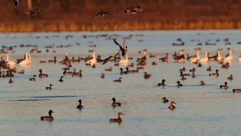
LITTLE ROCK – Finding ducks has proven harder this season than in recent years, according to many reports this office has gathered along the way. But it hasn’t slowed the demand, at least from the looks of the turnout this past weekend at Steve N. Wilson Raft Creek Bottoms Wildlife Management Area, as well as the growing number of weekly applicants for the permit draw used for the Arkansas Waterfowl Rice Incentive Conservation Enhancement program.
Raft Creek Bottoms, located just a short drive from Searcy, has both an online draw for duck holes and an in-person draw on Saturdays and Sundays (on Tuesdays and Thursdays, users merely have to show up and grab a permit at one of the visitor kiosks and return the permit after the hunt, though the youth blind, moblitiy-impaired blind and Magellan Tract are drawn online for those days as well). This past Saturday’s crowd at the in-person draw greatly exceeded the availability of hunting holes, and while the crowd was a little less on Sunday, there were still hunters who didn’t win a spot in the draw and had to head elsewhere.
Of course, the AGFC manages plenty of other areas that don’t require winning a draw to hunt, such as Henry Gray Hurricane Lake WMA and parts of Sheffield Nelson Dagmar WMA, both in close proxmitiy to Raft Creek Bottoms. Rex Hancock Black Swamp WMA in the Cache River area also has plenty of water now for good duck habitat and hunting. The only question is whether the ducks will cooperate.
The public hunting land in southwest Arkansas, particularly the units at Ozan WMA, has gotten a boost in habitat thanks to recent rainfaill. However, as AGFC biologist Eley Talley reports, “We did gain some huntable water on Ozan WMA but still not many birds anywhere.” Meanwhile, in the Arkansas River Valley area, AGFC biologist Alex Zachary says, All waterfowl impoundments on Ed Gordon Point Remove WMA should be at or near full pool at this time. Duck use on the WMA has been low to moderate, and hunter success has been generally poor.”
One interesting fact we did note, though we’re not certain it indicates a great number of ducks are present there: For the weekend of Jan. 9-10, a statewide high of 23 applicants tried for the Franklin Co. Alix Field in the AGFC’s WRICE draw for weekend hunting (though we need to note just 10 applicants tried for the same spot this coming weekend). The weekend of Jan. 9-10 also saw a season high of 273 applicants for the 40-plus WRICE fields available. The Arkansas Waterfowl Rice Incentive Conservation Enhancement program, in which landowners enlist rice acreage that is not tilled over in the program for waterfowl habitat, allows hunters to apply online for a weekend private rice field hunt. The two most popular fields in terms of applicants this year, one near Slovak and another near Georgetown, are again at the top of this weekend’s list: 24 applicants sought the Georgetown field and 17 tried for Slovak. To see the total number of applicants for the fields through the season, visit https://www.agfc.com/en/hunting/migratory-birds/waterfowl/special-waterfowl-permit-hunts/ and click on 2020-21 WRICE Weekly Application Numbers.
Applications for the permit draw to the WRICE fields, or weekend hunts at Steve N. Wilson Raft Creek Bottoms WMA, Red Cut Slough in Cypress Bayou WMA or the Conway George Tracts at Dagmar next weekend (Jan. 23-24) are available from noon Thursday to midnight Sunday. WRICE fields, unlike WMA permits, allow for two full days of hunting for the applicant selected for a field, and the hunting party can consist of up to four hunters. Permit winners are notified Monday following the close of the application period. The cost to apply for any permit in the draw is $5.
Arkansas’s regular waterfowl season continues uninterrupted to its close at sunset Jan. 31.
* * *
Observers flying the AGFC’s midwinter waterfowl survey last week estimated the greatest number of mallards in the Delta in the Bayou Meto, Little River, Lower White and Black River-Upper White survey zones. Several duck hotspots that were slightly different than mallard hotspots. Mallard estimates for mallards and total ducks in the Arkansas River Valley were less than half their 2014-2021 averages, with the vast majority of ducks observed in the West Dardanelle survey zone.
Observations common the last couple wintering periods held true again during this survey, namely that ducks remained concentrated on established waterfowl sanctuaries and habitats that appeared not to be actively hunted. Rainfall preceding this survey provided a bit of a boost in habitat availability. It is unclear how much of that habitat remains on the landscape now. Ducks were uncommon in these fields during these daytime surveys. Birds likely leaving sanctuary areas at night to take advantage of these new habitats. Big Lake National Wildlife Refuge and Lake Ashbaugh were noticeable hot spots, but at least some feedback about hunting success on adjacent public hunting areas suggests low success. Similar to last year, ducks seemed to be taking advantage of newly flooded fields without hunting pressure in the Lower St. Francis survey zone near the Mississippi River.
Observers estimated 1.08 million total ducks in the Delta, fewer than half of which were mallards (458,314). Duck population estimates in the Arkansas River Valley slightly exceed 21,000, including just over 9,000 mallards, while fewer than 5,000 mallards and barely over 9,000 total ducks were counted southwest Arkansas. Observers in the Delta estimated around 886,000 light (lesser snow and Ross’s) geese and about 221,000 greater white-fronted geese during this survey, with the caveat that this survey is not great for estimating goose numbers.
The Delta mallard population estimate is the second lowest since formal surveys began in the 2009-10 wintering period and represent only 45% of the 2010-2021 long-term midwinter survey average of about 826,000.
Northeast Arkansas
Big Lake WMA
Map | Water Gauge | Weather Report
When the Ditch 81 extension gauge near Manila (upstream of the Big Lake north-end control structure) reads 17.5 feet, water is beginning to come over the north levee degrade on Big Lake WMA. When the Ditch 81 Extension gauge reads 18.0 feet or higher, the water level on the WMA will rise quickly and hunters should exercise caution while on the area. Be aware of underwater logs in boat runs and hangers in trees.
A few ducks are moving through the area.
North Woods GTR
Habitat: Mast production is good.
Water Level: 100% flooded, Bo Dock gauge reading is 236.9 feet msl with a target level of 235.5 feet msl.
South Woods GTR
Habitat: Mast production is fair.
Water Level: 100% flooded. The 7-mile gauge is reading 236.1 feet msl; target level is 234.5 feet.
Simmons Field
Habitat: Good production of millet and sedge. Native production is very good in the north, middle and south fields with 5 acres of millet planted in the north field. All fields were rolled with a cleated roller in April.
Water Level: 100% coverage.
Dave Donaldson Black River WMA
Map | Water Gauge | Weather Report
Waterfowl hunters should be aware of hangers and submerged logs within the boat runs and GTRs. Please exercise caution when accessing the area. Please remember to keep boats off the levees so AGFC personnel can access the area. Boats blocking access will be moved. Unattended trailers are not to be left overnight on parking areas. River level is 7.9 feet msl and falling slowily.
Upper Island GTR
Habitat: Mast crop is moderate within the GTRs.
Water Level: Current level is 269.55 feet msl. Target level is 269.5 feet msl. 100% flooded.
Lower Island GTR
Habitat: Mast crop is moderate within the GTRs.
Water Level: Current level is 268.7 feet msl. Target level is 268.0 feet msl. 100% flooded.
Upper Reyno GTR
Habitat: Mast crop is moderate within the GTRs.
Water Level: Current level is 267.6 feet msl. Target level is 266.9 feet msl. 100% flooded.
Lower Reyno GTR
Habitat: Mast crop is moderate within the GTRs.
Water Level: Current level is 266.95 feet msl Target level is 266.3 feet msl. 100% flooded.
Winchester GTR
Habitat: Mast crop is moderate within the GTRs.
Water Level: Current level is 263.75 feet msl. Target level is 263.7 feet msl. 100% flooded.
Earl Buss Bayou DeView WMA
Map | Water Gauge | Weather Report
Boaters should use caution while using the Thompson Tract boat run. A few ducks and geese are moving through the area.
South Oliver GTR
Habitat: Mast production has been good.
Water Level: 100% flooded with a current gauge reading of 1.75 feet.
Thompson Tract GTR
Habitat: Mast production is good.
Water Level: 100% flooded with a current gauge reading of 1.45 feet.
Lake Hogue WRA
Habitat: Primarily deep open water habitat.
Water Level: Normal pool level.
Shirey Bay Rainey Brake WMA
Map | Water Gauge | Weather Report
Waterfowl hunters should be aware of hangers and submerged logs within the boat runs and GTRs. Please exercise caution when accessing the area. In addition, hunters should allow safe passage when parking vehicles along roadsides. Vehicles blocking access will be moved.
Adam Brake GTR
Habitat: Mast production is good.
Water Level: Water level is 240.0 feet msl with a target level of 240.0 msl. 100% flooded.
Rainey Brake GTR
Habitat: Mast production is good.
Water Level: 100% flooded.
Eagle Pond GTR
Habitat: Mast production is good.
Water Level: 100% flooded.
Phase III Moist-Soil Unit
Habitat: Good wetland-type vegetation.
Water Level: 85% flooded.
Charles Crisp Moist-Soil Unit
Habitat: Good wetland-type vegetation.
Water Level: 95% flooded.
Ward Field Moist-Soil Unit
Habitat: Good wetland-type vegetation.
Water Level: 100% flooded.
River Field Moist-Soil Unit
Habitat: Good wetland-type vegetation.
Water Level: 100% flooded.
St. Francis Sunken Lands WMA
Map | Water Gauge | Weather Report
Hunt Area
Habitat: Good mast production within the hunt area.
Water Level: Water levels on St. Francis Sunken Lands for waterfowl season are dependent on flows from the St. Francis River. The target level for providing huntable timber is 212.0 feet msl at the Oak Donnick gauge. As of Jan. 12, the reading was 212.16 feet msl.
Snowden WRA
Habitat: Mixed grasses.
Water Level: 10% flooded, mostly in the low-lying areas due to rain.
Payneway WRA
Habitat: A, B, C and D pools have mixed smartweed and barnyard grasses. Moderate mast is available within pools A, B and C as well.
Water Level: Pool A is at 5% coverage. Pool B is at 5%. Pool C is at 5%. Pool D is at 20%.
East-Central Arkansas
Henry Gray Hurricane Lake WMA
Map | Water Gauge | Weather Report
Hunters should call the Wildlife Hotline at 800-440-1477 for current road closures.
North GTR
Habitat: Good mast crop.
Water Level: The Glaise Creek reading on Dec. 28 was 193.43 feet msl; the North GRT is at full pool. All structures on the North GTR are closed.
South GTR
Habitat: Fair mast crop.
Water Level: The Glaise Creek reading is 193.43 feet msl; full pool is 192 feet msl.
Note: All structures on the South GTR are open.
Rex Hancock Black Swamp WMA
Map | Water Gauge | Weather Report
Hunters should call the Wildlife Hotline at 800-440-1477 for current road closures.
Gregory GTR
Habitat: Good mast crop.
Water Level: 100% (the Cache River level on Monday, Jan. 11, was at 8.4 feet and falling on the Patterson Gauge).
Wyeville Moist-Soil Unit
Habitat: Good stand of millet and native vegetation.
Water Level: 100% coverage.
Sheffield Nelson Dagmar WMA
Map | Water Gauge | Weather Report
The Conway George units are currently available for hunting by applying for online permits. Please visit www.agfc.com for maps, special regulations, permit application and draw dates. Hunters should call the Wildlife Hotline at 800-440-1477 for current road closures.
Mud Slough GTR
Habitat: Good mast crop.
Water Level: 50% coverage.
Apple Lake WRA
Habitat: Good mast crop.
Water Level: 70%.
Conway George Waterfowl Unit A
Habitat: Good stand of millet and native vegetation.
Water Level: 100%
Conway George Waterfowl Unit B
Habitat: Natural slough area with beneficial wetland plants.
Water Level: 100%
Conway George Waterfowl Unit C
Habitat: Good stand of millet and native vegetation.
Water Level: 100%
Steve N. Wilson Raft Creek Bottoms WMA
Map | Water Gauge | Weather Report
Raft Creek Bottoms WMA is open to waterfowl hunting Tuesday, Thursday, Saturday and Sunday only. Saturday and Sunday hunting has both in-person draws and an online permit draw via www.agfc.com. On Tuesday and Thursday, permits need to be picked up before hunting and returned to the permit box kiosk after the hunt. Waterfowl hunting is closed Monday, Wednesday and Friday. The Youth blind, Mobility-Impaired blind and teh Magellan Tract are available Tuesday, Thursday, Saturday and Sunday by online draw. Online draws for other weekend duck holes are held the Thursday-Sunday before the week of hunt.
Unit A
Habitat: Excellent stand of native vegetation.
Water Level: 100% coverage.
Unit B
Habitat: Excellent stand of millet and native vegetation.
Water Level: 100%
Unit C
Habitat: Good stand of native vegetation.
Water Level: 100%
Unit D (Youth Area)
Habitat: Good stand of native vegetation.
Water Level: 100%
Unit E
Habitat: Excellent stand of millet and native vegetation.
Water Level: 100%
Unit F
Habitat: Good stand of millet and native vegetation.
Water Level: 100%
Unit G
Habitat: Fair stand of millet and native vegetation.
Water Level: 100%
Unit H (Mobility-impaired blind)
Habitat: Excellent stand of native vegetation.
Water Level: 100%
Unit I
Habitat: Habitat conditions are poor.
Water Level: 100%
Unit J (Cypert Tract)
Habitat: Excellent stand of native vegetation.
Water Level: 100%
Unit K (Cypert Tract)
Habitat: Excellent stand of native vegetation.
Water Level: 90%
Unit L (Cypert Tract)
Habitat: Fair stand of native vegetation.
Water Level: 50%
Unit M (Magellan Tract)
Habitat: Fair stand of native vegetation.
Water Level: 100%
Central Arkansas
Bell Slough WMA
Map | Weather Report
The Bell Slough GTR is primarily rainfall dependent with the exception of a limited amount of water that the AGFC can back in and catch from Palarm Creek.
Bell Slough GTR
Habitat: Poor to moderate mast crop.
Water Level: 100% flooded.
Palarm Creek WRA
Habitat: Natural vegetation and planted millet.
Water Level: 85% flooded.
Craig D. Campbell Lake Conway Reservoir
Map | Weather Report
Habitat and water levels are normal on both Pierce and Dix creeks.
Cypress Bayou WMA
Hunt Area
Habitat:
Good mast crop.
Water Level: 100% coverage.
Red Cut Slough Tract
The six units of Cypress Bayou Red Cut Slough are available for permit-only hunting on Tuesday, Thursday, Saturday and Sunday. Weekend hunts are available only via online draw for permits through the website, www.agfc.com. On Tuesday and Thursday, hunters need to pick up a permit at the parking lot and return it after the hunt.
Unit 1
Habitat:
Good stand of millet and native vegetation.
Water Level: 75%
Unit 2
Habitat:
Excellent stand of millet and native vegatation
Water Level: 100%
Unit 3
Habitat:
Good stand of millet and native vegatation
Water Level: 100%
Unit 4
Habitat: Good stand of millet and native vegetation.
Water Level: 100%
Unit 5
Habitat:
Good stand of native vegetation.
Water Level: 40%
Unit 6
Habitat:
Good stand of native vegetation.
Water Level: 30%
Harris Brake WMA
Upper GTR
Habitat: Average mast crop.
Water Level: 100% full.
Lower GTR
Habitat: Average mast crop.
Water Level: 95% flooded. The Harris Brake Lake valve, opened Nov. 16 to begin supplemental flooding of both the Lower and Upper GTRs, was closed Dec. 17 after the GTR units were completed flooded.
Holland Bottoms WMA
WRA Moist-Soil Unit (East/West)
Habitat: Good mast crop.
Water Level: 45% coverage.
Lake Pickthorne WRA
Habitat: Excellent.
Water Level: East cell is 100%, West cell is 100%.
Northwest Arkansas
Dardanelle WMA
McKennon Bottoms (half-day hunting)
Habitat: 8 acres of native millet, 24 acres of fallow ground.
Water Level: 100%
Potter’s Pothole Hartman Waterfowl Unit (half-day hunting)
Habitat: Good stand of native vegetation.
Water Level: 100%
Ed Gordon Point Remove WMA
All waterfowl impoundments on Ed Gordon Point Remove WMA should be at or near full pool at this time. Duck use on the WMA has been low to moderate, and hunter success has been generally poor.
Little Hole (Unit 1)
Habitat: Natural vegetation.
Water Level: 100% flooded.
Willow Island (Unit 2)
Habitat: Natural vegetation.
Water Level: 100%
Red Gate (Unit 3)
Habitat: Natural vegetation and Japanese millet.
Water Level: 100%
Pig Trough (Units 4 and 5)
Habitat: Natural vegetation.
Water Level: 95%
Cedar Ridge (Unit 6)
Habitat: Natural vegetation.
Water Level: 95%
Unit 7a
Habitat: Japanese millet.
Water Level: 100%
Unit 7b
Habitat: Natural vegetation.
Water Level: 85%
Duck Trap (Units 8a, 8b and 8c)
8a
Habitat: Natural vegetation.
Water Level: 100%
8b
Habitat: Natural vegetation.
Water Level: 100%
8c
Habitat: Natural vegetation.
Water Level: 100%
Unit 9
Habitat: Natural vegetation.
Water Level: 100%
Controversy Corner (Unit 10)
Habitat: Natural vegetation and Japanese millet.
Water Level: 100%
Remmel Marsh
Habitat: Natural vegetation and Japanese millet.
Water Level: 100%
Mud Pond (Unit 12)
Habitat: Natural vegetation.
Water Level: 100%
Turkey Pond (Units 13a, 13b and 13c)
13a
Habitat: Natural vegetation and Japanese millet.
Water Level: 100%
13b
Habitat: Natural vegetation.
Water Level: 85%
13c
Habitat: Japanese millet.
Water Level: 100%
Teeny Pond (Unit 15)
Habitat: Natural vegetation and Japanese millet
Water Level: 90%
Salt Lick (Unit 15)
Habitat: Japanese millet.
Water Level: 100%
Bobby’s Pond (Unit 16)
Habitat: Japanese millet.
Water Level: 100%
Race Track (Unit 17)
Habitat: Japanese millet.
Water Level: 100%
Frog Bayou WMA (half-day hunting)
Unit 1
Habitat: Sprangletop, wild millet, smartweed, nutsedge, Japanese millet planted in the northwest corner.
Water Level: 100%
Unit 2
Habitat: Good stand of barnyard grass and nutsedge.
Water Level: 100%
Unit 3
Habitat: Smartweed, toothcup, nutsedge, barnyard grass, sprangletop and duck potato and Japanese millet planted in northwest corner.
Water Level: 80%
Unit 4
Habitat: Barnyard grass, sprangletop, annual smartweed, nutsedge and crabgrass.
Water Level: 100%
Unit 5
Habitat: Sprangletop, wild millet, smartweed, knotgrass, nutsedge and duck potato.
Water Level: 100%
Unit 6
Habitat: Barnyard grass, smartweed, crabgrass and sprangletop.
Water Level: 90%
Unit 7
Habitat: Excellent stand of barnyard grass, sprangletop and smartweed.
Water Level: 100%
Galla Creek WMA
Galla Creek GTR
Habitat: Moderate stand of planted millet and natural vegetation, including a mixture of barnyard grass and sprangletop.
Water Level: 100% flooded.
Nimrod Lloyd Millwood WMA
Nimrod GTR
Habitat: The red oak mast crop and desirable native vegetation growth this year was far less substantial than in previous years.
Water Level: 100% flooded.
Ozark Lake WMA/Dyer Lake Water Unit
Dyer Lake Cells (half-day hunting)
Habitat: Excellent stand of barnyard grass, toothcup, smartweed and sprangletop.
Water Level: Units 1 and 2, 100%.
Unit 3 South Cell: 75% (rainfall dependent), planted with millet.
Dyer West Cell: 0% coverage (had water control structure issues), planted with Japanese millet and chipwapa.
Petit Jean River WMA
Map | Water Gauge | Weather Report
Sorehead Moist-Soil Unit
Habitat: The unit contains a mix of moderate to great stands of desirable native vegetation throughout.
Water Level: 100%
Blacklands Moist-Soil Unit
Habitat: This unit this year contains one of the best stands of desirable native vegetation in recent years. The wooded areas inside the unit produced a below-average red oak mast crop this year.
Water Level: 100%.
Slaty Crossing Moist-Soil Unit
Habitat: Due to ongoing waterfowl habitat enhancement projects, this unit was not able to grow a desirable native vegetation crop this year. The area was seeded with Japanese millet after the project was completed. Only about half of the unit produced a crop of millet, but the areas that did produce look amazing.
Water Level: 100%
Blacklands Duck Area
Habitat: The wooded sections of this area produced a below-average red oak mast crop this year. This area also contains a mix of moderate to great stands of desirable native vegetation mixed throughout.
Water Level: 100%
Pullen Pond Marsh
Habitat: Due to ongoing waterfowl habitat enhancement projects, parts of the northeastern sections of this area are bare ground. Other parts of this area have spotted sections of great desirable native vegetation. The desirable native vegetation has started to become more and more prevalent with each year of ongoing management work.
Water Level: 100%.
Pond Creek GTR
Habitat: This area produced a less-than-desirable red oak mast crop this year with good stands of desirable native vegetation in the open lands within this area.
Water Level: 100%. Flooding of this area is rainfall dependent.
Slaty GTR
Habitat: This area produced a less-than-desirable red oak mast crop this year.
Water Level: 15%. Flooding of this area is rainfall dependent.
Santa Fe GTR
Habitat: This area produced a less-than-desirable red oak mast crop this year.
Water Level: 100%. Flooding of this area is rainfall dependent.
Southwest Arkansas
Dr. Lester Sitzes III Bois d’Arc WMA
Bois d’Arc Lake WRA
Habitat: Closed to hunting.
Water Level: Normal
Red Slough WRA
Habitat: Closed to hunting.
Water Level: 90%
GTR
Habitat: Good mast production.
Water Level: 100%
Little Grassy
Habitat: Good
Water Level: 100%
Millwood Lake
Map | Water Gauge | Weather Report
Habitat: Habitat conditions are good.
Water Level: 261.51 feet msl.
Ozan WMA
Unit 1
Habitat: Good
Water Level: 70%
Unit 2
Habitat: Good
Water Level: 60%
Unit 3
Habitat: Good
Water Level: 60%
Unit 4
Habitat: Good
Water Level: 75%
Unit 5
Habitat: Good
Water Level: 90%
Sulphur River WMA
Mercer Bayou
Habitat: Fair
Water Level: 100%
Henry Moore WRA
Habitat: Closed to hunting.
Water Level: 100%
Southeast Arkansas
Beryl Anthony Lower Ouachita WMA
Map | Weather Report
Water Level: Water is only available in the oxbow lakes located on the WMA and some river backwater is available. Clear Lake Road is closed to all vehicular access, including ATVs.
Cut-Off Creek WMA
Hunt Area
Habitat: Habitat conditions are good.
Water Level: Water levels are excessively high; portions of roads may be inaccessible due to flooding.
Pigeon Creek WRA
Habitat: Habitat conditions are good.
Water Level: Fully flooded.
Freddie Black Choctaw Island WMA Deer Research Area
Map | Water Gauge | Weather Report
Habitat conditions are good. Flooding is river dependent. Click on the Water Gauge link above for current Mississippi River levels. Use extreme caution when boating in river.
George H. Dunklin Jr. Bayou Meto WMA
Map | Water Gauge | Weather Report
The UGSG is now reporting real-time water gauge readings at the headwater at each GTR within the George H. Dunklin Bayou Meto WMA. Click the Water Gauge link above for the WMA, and search for the particular GTR as noted.
A good rule of thumb for comparing water levels to access into Bayou Meto: 176 feet msl – water breaking into sloughs and lower ditches; 177-177.5 feet msl – water beginning to break out of sloughs and lower ditches; 178 feet msl – water in most sloughs and ditches and entering into lower elevations in woods; 178.5 feet msl – most ditches and sloughs deep enough to boat and most boat ramps become serviceable; 179 feet msl or above – good duck hunting waters.
Upper Vallier GTR
Habitat: Good
Water Level: See Gauge Link (Upper Vallier Headwater)
Lower Vallier GTR
Habitat: Good
Water Level: See Gauge Link (Lower Vallier Headwater).
NOTE: Use caution operating boats near water control structures.
Government Cypress GTR
Habitat: Good
Water Level: See Gauge Link (Government Cypress Headwater)
Buckingham Flats GTR
Habitat: Good
Water Level: Pumping complete, 100% flooded. See Gauge Link (Buckingham Flats Headwater).
Temple Island GTR
Habitat: Good
Water Level: Pumping complete, 100% flooded. See Gauge Link (Temple Island Headwater).
Canon Brake
Habitat: Good
Water Level: See Gauge Link (Canon Brake Headwater). Use caution operating boats near water control structures.
Halowell WRA
Habitat: Excellent
Water Level: Flooding complete.
Wrape Plantation WRA
Habitat: Excellent
Water Level: Staggered flooding of units.
Seven Devils WMA
Hunt Area
Habitat: Habitat conditions are good.
Water Level: Water levels are excessively high; portions of roads may be inaccessible due to flooding.
Trusten Holder WMA
Map | Water Gauge | Weather Report
Habitat conditions are good. Flooding is river dependent. Click on the Water Gauge link above for current Arkansas River levels.
Recent News
Bull Shoals Mural Honors Dave Whitlock
Apr. 1, 2026

Subscribe to Our Weekly Newsletter E-mails
Don’t miss another issue. Sign up now to receive the AGFC Wildlife Weekly Newsletter in your mailbox every Wednesday afternoon (Waterfowl Reports are published weekly during waterfowl season and periodically outside the season). Fishing Reports arrive on Thursdays. Fill in the following fields and hit submit. Thanks, and welcome!