Arkansas Wildlife Waterfowl Report
BY Jim Harris
ON 12-02-2020
Dec. 2, 2020
Jim Harris
Managing Editor Arkansas Wildlife Magazine
Regular Duck Season Pauses; Youth, Veterans and Active Military Take the Stage
LITTLE ROCK – The first of two statewide Youth and Veterans/Active Military special waterfowl hunts will be held Saturday, Dec. 5. Both of these special hunt days (the second is Feb. 6, 2021) are not part of the regular 60-day scheduled season.
Meanwhile, regular duck season takes a break, resuming Friday, Dec. 11.
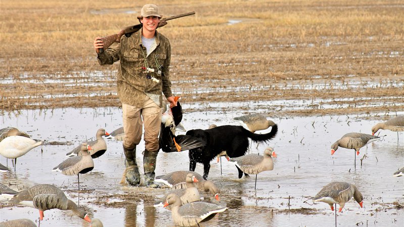
For another hunting option, though, duck hunters can turn their attention to greater white-fronted geese (specklebellies), which seemed to be in ample numbers throughout the Arkansas Delta, from northeast Arkansas through Arkansas County and beyond to the southern border. In the photo above, Cooper Smith of Marion, Illinois, enjoyed the specklebelly hunting near Harrisburg in northeast Arkansas last week.
Specklebellies may be hunted through Friday of this week, no hunting is allowed Saturday with the special hunt day for youths and military, and then it picks up again Sunday and continues until the Christmas break, Dec. 24-25, before resuming again on Dec. 26 and continuing concurrent with the duck season through Jan. 31. The specklebelly season was extended this year to 88 days, though the daily bag limit was trimmed from 3 in recent years to 2 this season.
(Where this writer hunted last weekend, in locations throughout Arkansas County, ducks seemed few and far between, but specklebellies and some snow and blue geese were still prevalent and moving between fields and their roosting ponds).
Some hunters have had success with ducks, but the biggest question most Arkansas hunters likely have uttered during the first segment of the season is, “Where are the ducks?”
Luke Naylor, Arkansas Game and Fish Commission waterfowl program coordinator, explains the “spotty” hunting for the first two weekends: “We need water, bad. It’s not unexpected to have dry conditions throughout November. September, October and November are some of the driest months of the year, but as we’re moving into December it’s staying dry.
“Some hunters will say that the best thing we can have is dry conditions because ducks don’t have many options and it’s a captive audience. But that doesn’t seem to be the case for bringing ducks into the state. Overall surface water extent leads to abundant mallards in the Delta and we just don’t have that. Yeah, maybe in drier conditions ducks can be concentrated and ducks and people interact more, but statewide, to bring ducks in and get them moving, we need new and more habitat.”
Naylor was hopeful this week’s cold front pushing through might help move more numbers of ducks toward the state, “but a cold front with no rain doesn’t necessarily change things a whole lot.” The best cold front, he added, would be one following a 4-to-6-inch rain. “That’s when the good stuff happens.”
So, this 10-day break in the season is a good one, he says. The early segment of hunting traditionally is hit-and-miss across most of the state. In some years, conditions line up to provide a superb opening to the season, but it’s rare. When this season resumes, “maybe things will change,” Naylor said. “I wish the long-term forecast had more rain in it.” The Arkansas River Valley is extremely dry and duck numbers are not good there, he added.
As for Saturday’s special hunt day, youths under 16 may hunt as long as they are accompanied by a mentor – youths who have not completed the Hunter Education course must be accompanied by a mentor 21 or older; those who have completed the course can be accompanied by a mentor 18 or older. The mentor cannot hunt but can call the ducks, set decoys, help retrieve game and such.
Active duty military and military veterans may harvest ducks, geese, coots and mergansers. Active duty military includes members of the National Guard and Reserves on active duty (other than for training). Veterans must have served in active military, naval, air service or Reserves and National Guard on Title 32 orders in a combat zone and must have been discharged or released under honorable conditions. Hunters will need to have one of the following or copy during the hunt: DD214, Veteran Benefit Card, Retired Active Military I.D., Veteran Hunting License (VLF, VLH, VLC or VLL) or Active Duty I.D. card.
Shooting hours and bag limits are the same as regular duck and goose seasons. Hunters may hunt on wildlife management areas from 30 minutes before sunrise until sunset these two days. WMA General Use permits are required for active military and veterans; they are NOT required for youth hunters.
Remember that while state and federal stamps, license, HIP and WMA General Use permit purchases are shown online, hunters will still need to have their federal duck stamp on their possession and signed across the front, if the stamp was purchased more than 45 days ago. There is a 45-day grace period for having the federal stamp in the hunter’s possession.
Also, remember that while duck hunting is on a break, it’s still time this week to think about applying for special permits that will offer hunting opportunity the weekend of Dec.12-13, such as the WRICE Program and hunts at Steve N. Wilson Raft Creek Bottoms WMA and Sheffield Nelson Dagmar WMA. Visit the Special Permit Page on the agfc.com website for information on all the available permits for waterfowl hunting and a link to apply.
Northeast Arkansas
Big Lake WMA
Map | Water Gauge | Weather Report
When the Ditch 81 extension gauge near Manila (upstream of the Big Lake north-end control structure) reads 17.5 feet, water is beginning to come over the north levee degrade on Big Lake WMA. When the Ditch 81 Extension gauge reads 18.0 feet or higher, the water level on the WMA will rise quickly and hunters should exercise caution while on the area. Be aware of underwater logs in boat runs and hangers in trees.
Some ducks are moving through the area.
North Woods GTR
Habitat: Mast production is good.
Water Level: Bo Dock guage currently reads 235.5 feet msl; target level is 235.5 feet with 100% flooded.
South Woods GTR
Habitat: Mast production is fair.
Water Level: The 7-Mile gauge is currently at 234.5 feet msl; target level is 234.5 feet with 100% flooded.
Simmons Field
Habitat: Good production of millet and sedge. Native production is very good in the north, middle and south fields with 5 acres of millet planted in the north field. All fields were rolled with a cleated roller in April.
Water Level: 80% coverage.
Dave Donaldson Black River WMA
Map | Water Gauge | Weather Report
Waterfowl hunters should be aware of hangers and submerged logs within the boat runs and GTRs. Please exercise caution when accessing the area. Please remember to keep boats off the levees so AGFC personnel can access the area. Boats blocking access will be moved. Unattended trailers are not to be left overnight on parking areas. River level is 9.74 feet msl and expected to rise.
Upper Island GTR
Habitat: Mast crop is moderate within the GTRs.
Water Level: Current level is 270.1 feet msl. Target level is 269.5 feet msl. 100% flooded.
Lower Island GTR
Habitat: Mast crop is moderate within the GTRs.
Water Level: Current level is 268.825 feet msl. Target level is 268.0 feet msl. 100% flooded.
Upper Reyno GTR
Habitat: Mast crop is moderate within the GTRs.
Water Level: Current level is 267.65 feet msl. Target level is 266.9 feet msl. 100% flooded.
Lower Reyno GTR
Habitat: Mast crop is moderate within the GTRs.
Water Level: Current level is 266.975 feet msl Target level is 266.3 feet msl. 100% flooded.
Winchester GTR
Habitat: Mast crop is moderate within the GTRs.
Water Level: Water level is 263.75 feet msl; target level is 263.7 feet msl. 100% flooded.
Earl Buss Bayou DeView WMA
Map | Water Gauge | Weather Report
Boaters should use caution while using the Thompson Tract boat run. A few ducks are moving through the area.
South Oliver GTR
Habitat: Mast production has been good.
Water Level: 10% flooded with a current gauge reading of 0.0 foot. Water is located within the natural sloughs.
Thompson Tract GTR
Habitat: Mast production is good.
Water Level: 25% flooded with a current gauge reading of 0.7 foot.
Lake Hogue WRA
Habitat: Primarily deep open water habitat.
Water Level: Normal pool level.
Shirey Bay Rainey Brake WMA
Map | Water Gauge | Weather Report
Waterfowl hunters should be aware of hangers and submerged logs within the boat runs and GTRs. Please exercise caution when accessing the area. In addition, hunters should allow safe passage when parking vehicles along roadsides. Vehicles blocking access will be moved.
Adam Brake GTR
Habitat: Mast production is good.
Water Level: Water level is 238.7 feet msl with a target level of 240.0 msl. 50% flooded.
Rainey Brake GTR
Habitat: Mast production is good.
Water Level: 95% flooded.
Eagle Pond GTR
Habitat: Mast production is good.
Water Level: 100% flooded.
Phase III Moist-Soil Unit
Habitat: Good wetland-type vegetation.
Water Level: 25% flooded.
Charles Crisp Moist-Soil Unit
Habitat: Good wetland-type vegetation.
Water Level: 60% flooded.
Ward Field Moist-Soil Unit
Habitat: Good wetland-type vegetation.
Water Level: 75% flooded.
River Field Moist-Soil Unit
Habitat: Good wetland-type vegetation.
Water Level: 75% flooded.
St. Francis Sunken Lands WMA
Map | Water Gauge | Weather Report
Hunt Area
Habitat: Good mast production within the hunt area.
Water Level: Water levels on St. Francis Sunken Lands for waterfowl season are dependent on flows from the St. Francis River. The target level for providing huntable timber is 212.0 feet msl at the Oak Donnick gauge. As of Nov. 30, levels were 213.76 feet msl.
Snowden WRA
Habitat: Mixed grasses.
Water Level: 0% flooded, mostly in the low-lying areas due to rain.
Payneway WRA
Habitat: A, B, C and D pools have mixed smartweed and barnyard grasses. Moderate mast is available within pools A, B and C as well.
Water Level: Pool A is at 0% coverage. Pool B is at 0%. Pool C is at 0%. Pool D is at 0%.
East-Central Arkansas
Henry Gray Hurricane Lake WMA
Map | Water Gauge | Weather Report
Hunters should call the Wildlife Hotline at 800-440-1477 for current road closures.
North GTR
Habitat: Good mast crop.
Water Level: The current Glaise Creek reading is 192.65 feet msl and the North GRT is at full pool. All structures on the North GTR are closed.
South GTR
Habitat: Fair mast crop.
Water Level: The Glaise Creek reading is 192.65 feet msl; full pool is 192 feet msl.
Note: All structures on the South GTR are open.
Rex Hancock Black Swamp WMA
Map | Water Gauge | Weather Report
Hunters should call the Wildlife Hotline at 800-440-1477 for current road closures.
Gregory GTR
Habitat: Good mast crop.
Water Level: 80% (the Cache River level as of Monday is 9.0 feet msl and rising at the Patterson Gauge).
Wyeville Moist-Soil Unit
Habitat: Good stand of millet and native vegetation.
Water Level: 100% coverage.
Sheffield Nelson Dagmar WMA
Map | Water Gauge | Weather Report
The Conway George units are currently available for hunting by applying for online permits. Please visit www.agfc.com for maps, special regulations, permit application and draw dates. Hunters should call the Wildlife Hotline at 800-440-1477 for current road closures.
Mud Slough GTR
Habitat: Good mast crop.
Water Level: 25% coverage.
Apple Lake WRA
Habitat: Good mast crop.
Water Level: 80%.
Conway George Waterfowl Unit A
Habitat: Good stand of millet and native vegetation.
Water Level: 100%
Conway George Waterfowl Unit B
Habitat: Natural slough area with beneficial wetland plants.
Water Level: 100%
Conway George Waterfowl Unit C
Habitat: Good stand of millet and native vegetation.
Water Level: 100%
Steve N. Wilson Raft Creek Bottoms WMA
Map | Water Gauge | Weather Report
Raft Creek Bottoms WMA is open to waterfowl hunting Tuesday, Thursday, Saturday and Sunday only. Saturday and Sunday hunting has both in-person draws and an online permit draw via www.agfc.com. On Tuesday and Thursday, permits need to be picked up before hunting and returned to the work center off Jones Island Road after the hunt. Waterfowl hunting is closed Monday, Wednesday and Friday. The Youth blind and Mobility-Impaired blind are available Tuesday, Thursday, Saturday and Sunday by online draw. The Magellan Tract is available to online drawing. Online draws are held the Thursday-Sunday before the week of hunt.
Unit A
Habitat: Excellent stand of native vegetation.
Water Level: 50% coverage.
Unit B
Habitat: Excellent stand of millet and native vegetation.
Water Level: 50%
Unit C
Habitat: Good stand of native vegetation.
Water Level: 45%
Unit D (Youth Area)
Habitat: Good stand of native vegetation.
Water Level: 100%
Unit E
Habitat: Excellent stand of millet and native vegetation.
Water Level: 95%
Unit F
Habitat: Good stand of millet and native vegetation.
Water Level: 95%
Unit G
Habitat: Fair stand of millet and native vegetation.
Water Level: 30%
Unit H (Mobility-impaired blind)
Habitat: Excellent stand of native vegetation.
Water Level: 100%
Unit I
Habitat: Habitat conditions are poor.
Water Level: 100%
Unit J (Cypert Tract)
Habitat: Excellent stand of native vegetation.
Water Level: 60%
Unit K (Cypert Tract)
Habitat: Excellent stand of native vegetation.
Water Level: 40%
Unit L (Cypert Tract)
Habitat: Fair stand of native vegetation.
Water Level: 15%
Unit M (Magellan Tract)
Habitat: Fair stand of native vegetation.
Water Level: 50%
Central Arkansas
Bell Slough WMA
Map | Weather Report
The Bell Slough GTR is primarily rainfall dependent with the exception of a limited amount of water that the AGFC can back in and catch from Palarm Creek.
Bell Slough GTR
Habitat: Poor to moderate mast crop.
Water Level: 50% flooded.
Palarm Creek WRA Units 1 and 2
Habitat: Natural vegetation and planted millet.
Water Level: 50% flooded.
Craig D. Campbell Lake Conway Reservoir
Map | Weather Report
Habitat and water levels are normal on both Pierce and Dix creeks.
Cypress Bayou WMA
Hunt Area
Habitat:
Good mast crop.
Water Level: 100% coverage.
Red Cut Slough Tract
The six units of Cypress Bayou Red Cut Slough are available for permit-only hunting on Tuesday, Thursday, Saturday and Sunday. Weekend hunts are available only via online draw for permits through the website, www.agfc.com. On Tuesday and Thursday, hunters need to pick up a permit at the parking lot and return it after the hunt. There was no huntable habitat in most of Red Cut Slough last week and therefore no permit draw for on the first two weekends. No permits were drawn for the youth weekend (Dec. 5) as well. The lake (Unit 6) is available to hunt Tuesday and Thursday by permit picked up at the parking lot. If the area receives significant rainfall, AGFC staff is hoping to pump and have some water available for the second season beginning Dec. 12.
Unit 1
Habitat:
Good stand of millet and native vegetation.
Water Level: 25%
Unit 2
Habitat:
Excellent stand of millet and native vegatation
Water Level: 15%
Unit 3
Habitat:
Good stand of millet and native vegatation
Water Level: 100%
Unit 4
Habitat: Good stand of millet and native vegetation.
Water Level: 10%
Unit 5
Habitat:
Good stand of native vegetation.
Water Level: 15%
Unit 6
Habitat:
Good stand of native vegetation.
Water Level: 15%
Harris Brake WMA
Upper GTR
Habitat: Average mast crop this year.
Water Level: 80% coverage.
Lower GTR
Habitat: Average mast crop this year.
Water Level: 70% flooded.
NOTES: The water control structures on both the Lower and Upper GTRs were closed on Monday, Nov. 16. The Harris Brake Lake valve was opened on Nov. 16 to begin supplemental flooding of both the Lower and Upper GTRs.
Holland Bottoms WMA
WRA Moist-Soil Unit (East/West)
Habitat: Good mast crop.
Water Level: 10% coverage.
Lake Pickthorne WRA
Habitat: Excellent.
Water Level: East cell is 25%, West cell is 75%.
Northwest Arkansas
Dardanelle WMA
McKennon Bottoms (half-day hunting)
Habitat: 8 acres of native millet, 24 acres of fallow ground.
Water Level: 100%
Potter’s Pothole Hartman Waterfowl Unit (half-day hunting)
Habitat: Good stand of native vegetation.
Water Level: 90%
Ed Gordon Point Remove WMA
Conditions on Ed Gordon Point Remove WMA remain fairly dry. Pumping of waterfowl impoundments began on Nov. 4 and staggered flooding of units will continue as water levels in Point Remove Creek allow. Most waterfowl impoundments are between 50%-80% flooded at this time. Duck use on the WMA has been low, and hunter success has been generally poor.
Little Hole (Unit 1)
Habitat: Natural vegetation.
Water Level: 70% flooded.
Willow Island (Unit 2)
Habitat: Natural vegetation.
Water Level: 90%
Red Gate (Unit 3)
Habitat: Natural vegetation and Japanese millet.
Water Level: 75%
Pig Trough (Units 4 and 5)
Habitat: Natural vegetation.
Water Level: 75%
Cedar Ridge (Unit 6)
Habitat: Natural vegetation.
Water Level: 50%
Unit 7a
Habitat: Japanese millet.
Water Level: 80%
Unit 7b
Habitat: Natural vegetation.
Water Level: 10%
Duck Trap (Units 8a, 8b and 8c)
8a
Habitat: Natural vegetation.
Water Level: 65%
8b
Habitat: Natural vegetation.
Water Level: 50%
8c
Habitat: Natural vegetation.
Water Level: 75%
Unit 9
Habitat: Natural vegetation.
Water Level: 90%
Controversy Corner (Unit 10)
Habitat: Natural vegetation and Japanese millet.
Water Level: 65%
Remmel Marsh
Habitat: Natural vegetation and Japanese millet.
Water Level: 80%
Mud Pond (Unit 12)
Habitat: Natural vegetation.
Water Level: 90%
Turkey Pond (Units 13a, 13b and 13c)
13a
Habitat: Natural vegetation and Japanese millet.
Water Level: 50%
13b
Habitat: Natural vegetation.
Water Level: 10%
13c
Habitat: Japanese millet.
Water Level: 45%
Teeny Pond (Unit 15)
Habitat: Natural vegetation and Japanese millet
Water Level: 0%
Salt Lick (Unit 15)
Habitat: Japanese millet.
Water Level: 60%
Bobby’s Pond (Unit 16)
Habitat: Japanese millet.
Water Level: 60%
Race Track (Unit 17)
Habitat: Japanese millet.
Water Level: 60%
Frog Bayou WMA (half-day hunting)
Unit 1
Habitat: Sprangletop, wild millet, smartweed, nutsedge, Japanese millet planted in the northwest corner.
Water Level: 100%
Unit 2
Habitat: Good stand of barnyard grass and nutsedge.
Water Level: 100%
Unit 3
Habitat: Smartweed, toothcup, nutsedge, barnyard grass, sprangletop and duck potato and Japanese millet planted in northwest corner.
Water Level: 80%
Unit 4
Habitat: Barnyard grass, sprangletop, annual smartweed, nutsedge and crabgrass.
Water Level: 100%
Unit 5
Habitat: Sprangletop, wild millet, smartweed, knotgrass, nutsedge and duck potato..
Water Level: 60%
Unit 6
Habitat: Barnyard grass, smartweed, crabgrass and sprangletop.
Water Level: 50%, pumping begins Dec. 2.
Unit 7
Habitat: Excellent stand of barnyard grass, sprangletop and smartweed.
Water Level: 50%, pumping begins Dec. 2.
Galla Creek WMA
Galla Creek GTR
Habitat: Moderate stand of planted millet and natural vegetation, including a mixture of barnyard grass and sprangletop.
Water Level: 35% flooded.Staged flooding of the impoundment began Nov. 12.
Nimrod Lloyd Millwood WMA
Nimrod GTR
Habitat: The red oak mast crop and desirable native vegetation growth this year was far less substantial than in previous years.
Water Level: 5% flooded.
NOTES: The water control structures were closed Monday, Nov. 16. Flooding of this area is rainfall dependent.
Ozark Lake WMA/Dyer Lake Water Unit
Dyer Lake Cells (half-day hunting)
Habitat: Excellent stand of barnyard grass, toothcup, smartweed and sprangletop.
Water Level: Units 1 and 2, 100%. Units 3 south cell (rainfall dependent), 75%, planted with millet. West cell, 0% coverage, had structure issues, planted with Japanese millet and chipwapa.
Petit Jean River WMA
Map | Water Gauge | Weather Report
Sorehead Moist-Soil Unit
Habitat: The unit contains a mix of moderate to great stands of desirable native vegetation throughout.
Water Level: 100%
Blacklands Moist-Soil Unit
Habitat: This unit this year contains one of the best stands of desirable native vegetation in recent years. The wooded areas inside the unit produced a below-average red oak mast crop this year.
Water Level: 100%.
Slaty Crossing Moist-Soil Unit
Habitat: Due to ongoing waterfowl habitat enhancement projects, this unit was not able to grow a desirable native vegetation crop this year. The area was seeded with Japanese millet after the project was completed. Only about half of the unit produced a crop of millet, but the areas that did produce look amazing.
Water Level: 0%
NOTES: The ongoing work within this unit has increased the overall floodable ground by cutting down the high spots that normally stayed dry. The dirt from these high spots was used to fill in the ditches. This area will not be flooded until the first week of December to allow the millet stand to fully mature.
Blacklands Duck Area
Habitat: The wooded sections of this area produced a below-average red oak mast crop this year. This area also contains a mix of moderate to great stands of desirable native vegetation mixed throughout.
Water Level: 100%
Pullen Pond Marsh
Habitat: Due to ongoing waterfowl habitat enhancement projects, parts of the northeastern sections of this area are bare ground. Other parts of this area have spotted sections of great desirable native vegetation. The desirable native vegetation has started to become more and more prevalent with each year of ongoing management work.
Water Level: 20%. The water control structures were closed at the end of October. Flooding of this area is rainfall dependent.
Pond Creek GTR
Habitat: This area produced a less-than-desirable red oak mast crop this year with good stands of desirable native vegetation in the open lands within this area.
Water Level: 0%. The water control structures were closed on Monday, Nov. 16. Flooding of this area is rainfall dependent.
Slaty GTR
Habitat: This area produced a less-than-desirable red oak mast crop this year.
Water Level: 5%. The water control structures were closed on Monday, Nov. 16. Flooding of this area is rainfall dependent.
Santa Fe GTR
Habitat: This area produced a less-than-desirable red oak mast crop this year.
Water Level: 0%. Flooding of this area is rainfall dependent.
Southwest Arkansas
Dr. Lester Sitzes III Bois d’Arc WMA
Bois d’Arc Lake WRA
Habitat: Closed to hunting.
Water Level: Normal
Red Slough WRA
Habitat: Closed to hunting.
Water Level: 0%
GTR
Habitat: Good mast production.
Water Level: 0%
Little Grassy
Habitat: Good
Water Level: 40%
Millwood Lake
Map | Water Gauge | Weather Report
Habitat: Habitat conditions are good.
Water Level: 259.46 feet msl.
Ozan WMA
Unit 1
Habitat: Good
Water Level: 0%
Unit 2
Habitat: Good
Water Level: 0%
Unit 3
Habitat: Good
Water Level: 0%
Unit 4
Habitat: Good
Water Level: 0%
Unit 5
Habitat: Good
Water Level: 0%
Sulphur River WMA
Mercer Bayou
Habitat: Fair
Water Level: 10%
Henry Moore WRA
Habitat: Closed to hunting.
Water Level: 10%
Southeast Arkansas
Beryl Anthony Lower Ouachita WMA
Map | Weather Report
Water Level: No duck hunting water. Water is available in the oxbow lakes located in the WMA.
Cut-Off Creek WMA
Hunt Area
Habitat: Habitat conditions are good.
Water Level: No water.
Pigeon Creek WRA
Habitat: Habitat conditions are good.
Water Level: No water, pumping ongoing based on creek levels.
Freddie Black Choctaw Island WMA Deer Research Area
Map | Water Gauge | Weather Report
Habitat conditions are good. Flooding is river dependent. Click on the Water Gauge link above for current Mississippi River levels. Use extreme caution when boating in river.
George H. Dunklin Jr. Bayou Meto WMA
Map | Water Gauge | Weather Report
The UGSG is now reporting real-time water gauge readings at the headwater at each GTR within the George H. Dunklin Bayou Meto WMA. Click the Water Gauge link above for the WMA, and search for the particular GTR as noted.
A good rule of thumb for comparing water levels to access into Bayou Meto: 176 feet msl – water breaking into sloughs and lower ditches; 177-177.5 feet msl – water beginning to break out of sloughs and lower ditches; 178 feet msl – water in most sloughs and ditches and entering into lower elevations in woods; 178.5 feet msl – most ditches and sloughs deep enough to boat and most boat ramps become serviceable; 179 feet msl or above – good duck hunting waters.
Upper Vallier GTR
Habitat: Good
Water Level: See Gauge Link (Upper Vallier Headwater)
NOTE: Jefferson County Road portion of the Mulberry Access has a bridge that has been repladed and is now accessible.
Lower Vallier GTR
Habitat: Good
Water Level: See Gauge Link (Lower Vallier Headwater). Use caution around water control structures.
Government Cypress GTR
Habitat: Good
Water Level: See Gauge Link (Government Cypress Headwater)
Buckingham Flats GTR
Habitat: Good
Water Level: No water; water is too low to pump. See Gauge Link (Buckingham Flats Headwater).
Temple Island GTR
Habitat: Good
Water Level: No water; water is too low to pump. See Gauge Link (Temple Island Headwater).
Canon Brake
Habitat: Good
Water Level: See Gauge Link (Canon Brake Headwater). Use caution around water control structures.
Halowell WRA
Habitat: Excellent
Water Level: Staggered flooding of units.
Wrape Plantation WRA
Habitat: Excellent
Water Level: Staggered flooding of units.
Seven Devils WMA
Hunt Area
Habitat: Habitat conditions are good.
Water Level: No water.
Trusten Holder WMA
Map | Water Gauge | Weather Report
Habitat conditions are good. Flooding is river dependent. Click on the Water Gauge link above for current Arkansas River levels.
Recent News
AGFC Commissioner Meeting Notice
Jul. 8, 2025
AGFC fish attractors unlock offshore fishing code
Jul. 8, 2025
Subscribe to Our Weekly Newsletter E-mails
Don’t miss another issue. Sign up now to receive the AGFC Wildlife Weekly Newsletter in your mailbox every Wednesday afternoon (Waterfowl Reports are published weekly during waterfowl season and periodically outside the season). Fishing Reports arrive on Thursdays. Fill in the following fields and hit submit. Thanks, and welcome!