Arkansas Wildlife Waterfowl Report
BY Jim Harris
ON 11-20-2019
Nov. 20, 2019
Jim Harris
Managing Editor Arkansas Wildlife Magazine
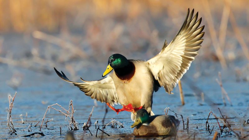
60-day Duck Season Kicks Off Saturday With Some Notable Changes
Friday Update to Earl Buss Bayou DeView WMA, Big Lake WMA; Entry time Changed at Dale Bumpers White River NWR North Unit
LITTLE ROCK – Waterfowl season in Arkansas officially opens 30 minutes before sunrise Saturday. In what has become standard in the state for two decades now, Arkansans will enjoy a 60-day duck season with two splits secheduled. Also, this year’s season will go longer than any previous one, with the final day being Jan. 31. Typically, the Arkansas season has ended on the last Sunday of January, but a change at the U.S. Fish & Wildlife Service level allowed Arkansas to extend to the very end of the month.
A couple of cold fronts that passed through the state recently, along with colder temps to the north of Arkansas, appeared to push a good number of ducks into parts of the state this past week, according to observations and anecdotal reports. However, temperatures had begun to rise again in Arkansas this week, so it’s hard to say how that might affect the opening weekend. The good news in Arkansas is that many of the Arkansas Game and Fish Commission’s public lands have excellent habitat conditions in terms of food for the migrating birds (note the habitat list of all WMAs that follows this story).
Evidence this spring in the duck breeding grounds indicates that duck populations are similar to last year’s count. But as hunters can easily recall, last year Arkansas was swamped from border to border with rainfall that spread the waterfowl population far and wide across The Natural State and affected hunting in many spots that usually see better harvest numbers. The overall harvest estimates in Arkansas, though, aligned closely with past figures.
Luke Naylor, AGFC Waterfowl Program Coordinator, warns that even if population totals were similar to last year, actual duck production this nesting season (which isn’t assessed until after duck season), different weather patterns and habitat conditions in Arkansas once winter arrives can change each hunter’s outcome in this complex system. “In general, we like to think we have a good enough handle on things to do a sort of pregame prediction,” Naylor said. “I just want hunters to be realistic about their expectations when they see the totals and say it’s going to be a great year. I don’t think anyone can predict that.”
The daily bag limit for ducks remains six, four of which can be mallards (only two of those may be hens). However, there have been some other changes to the daily limit that are worth noting. Canvasback and black duck limits were increased from one to two per day. But the daily bag limit for pintails decreased from two to one per day.
Also new this year is a Veterans Hunt, another move on the national level which was adopted here, which will take place on both of the days scheduled for Youth Hunts, Dec. 7 and Feb 8. Both active duty military and veterans may hunt on those days, which are not part of the 60-day scheduled season. Youths under 16 may hunt on those days as well, as long as they are accompanied by a mentor — those youths who have not completed the Hunter Education course must be accompanied by a mentor 21 or older; those who have completed the course can be accompanied by a mentor 18 or older. The mentor cannot hunt but can call the ducks.
On those same days, members of active duty military and military veterans may harvest ducks, geese, coots and mergansers. Active duty military includes members of the National Guard and Reserves on active duty (other than for training). Veterans must have served in active military, naval, air service or Reserves and National Guard on Title 32 orders in a combat zone and must have been discharged or released under honorable conditions. Hunters will need to have one of the following or copy during the hunt: DD214, Veteran Benefit Card, Retired Active Military I.D., Veteran Hunting License (VLF, VLH, VLC or VLL) or Active Duty I.D. card. Shooting hours and bag limits are the same as regular duck and goose seasons. Hunters may hunt on wildlife management areas from 30 minutes before sunrise until sunset these two days. WMA General Use permits are required for active military and veterans; they are NOT required for youth hunters.
Other regulation changes of note: The nonresident 5-day WMA waterfowl hunting permit is now good for any WMA during the 5-day hunt period. Also, nonresidents have been lmited to only being able to hunt on WMAs on certain dates this season.
One major change that waterfowl hunters who use the Dale Bumpers White River National Wildlife Refuge should note: The refuge is foregoing the 4 a.m. regulation for daily entrance into the north unit (above Arkansas Highway 1) for hunting. Instead, hunters may arrive at their preferred hunting spot at 8 p.m. the preceding day, presuming they want to wait around 8 hours until shooting time. This change, according to the refuge, is to alleviate some of the difficulty that is incurred by the limited access into the north unit. The 4 a.m. regulation is still in effect in the south unit of Dale Bumpers White River NWR. Also, remember (this began last year) that all users of the NWR must obtain a $20 permit (a one-time annual fee) to hunt in the refuge. Dale Bumpers White River NWR is the only national wildlife refuge in the state that charges for a permit. All other NWRs require a free sign-and-carry permit for uses.
Also, remember that while all stamp, license, HIP and WMA General Use permit purchases are shown online, hunters will still need to have their federal duck stamp on their possession and signed across the front, if the stamp was purchases more than 45 days ago. There is a 45-day grace period for having the federal stamp in the hunter’s possession.
Along with ducks, coots and mergansers, hunters in Arkansas beginning Saturday may also take snow, blue and Ross’s geese, as well as white-fronted geese (specklebellies) and Canada geese during the 60-day season. Refer to the AGFC’s Waterfowl Hunting Guidebook for daily bag limits and restrictions.
Northeast Arkansas
Big Lake WMA
Map | Water Gauge | Weather Report
When the Ditch 81 extension gauge near Manila (upstream of the Big Lake north-end control structure) reads 17.5 feet, water is beginning to come over the north levee degrade on Big Lake WMA. When the Ditch 81 Extension gauge reads 18.0 feet or higher, the water level on the WMA will rise quickly and hunters should exercise caution while on the area. Be aware of underwater logs in boat runs and hangers in trees.
Big Lake NWR is holding an above average number of ducks for this time of year. UPDATE: The North water control structure is operational, and flooding of the WMA has proceeded.
North Woods GTR
Habitat: Mast production is good.
Water Level: Bo Dock guage currently reads 235.2 feet msl; target level is 235.5 feet with 85% flooded.
South Woods GTR
Habitat: Mast production is fair.
Water Level: The 7-Mile gauge is currently at 234.4 feet msl; target level is 234.5 feet with 95 percent flooded.
Simmons Field
Habitat: A good amount of millet and sedge is present. Seed production is very good in north unit, middle fied, and south field was stripped in Japanese millet with strips of wild millet and sedge that did extremely well.
Water Level: 100% coverage.
Dave Donaldson Black River WMA
Map | Water Gauge | Weather Report
Waterfowl hunters should be aware of hangers and submerged logs within the boat runs and GTRs. Please exercise caution when accessing the area. Please remember to keep boats off the levees so AGFC personnel can access the area. Boats blocking access will be moved. Unattended trailers are not to be left overnight on parking areas.
Upper Island GTR
Habitat: Mast c rop is moderate within the GTRs.
Water Level: Water level is 269.15; target level is 269.5 feet msl. 80% flooded.
Lower Island GTR
Habitat: Moderage mast crop within the GTRs.
Water Level: Water level is 267/9 feet msl; target level is 268.0 feet msl. 85% flooded.
Upper Reyno GTR
Habitat: Moderate mast crop within the GTRs.
Water Level: Water level is 266.95 feet msl; target level is 266.9 feet msl. 100% flooded.
Lower Reyno GTR
Habitat: Moderate mast crop within the GTRs.
Water Level: Water level is 266.1 feet msl; target level is 266.3 feet msl. 85% flooded.
Winchester GTR
Habitat: Moderate mast crop within the GTRs.
Water Level: Water level is 263.6 feet msl; target level is 263.7 feet msl. 90% flooded.
Earl Buss Bayou DeView WMA
Map | Water Gauge | Weather Report
Boaters should use caution while using the Thompson Tract boat run. A few ducks and geese are moving through the area.
UPDATED AS OF FRIDAY, NOV. 22; THE BAYOU DEVIEW RIVER, ON THE EAST SIDE OF THE WMA, IS RISING DUE TO FALL HEAVY RAINFALL THURSDAY-FRIDAY.
South Oliver GTR
Habitat: Mast production has been good.
Water Level: 10% flooded with a current gauge reading of 0.1 feet. Most water is currently located in the natural slough on the north end.
Thompson Tract GTR
Habitat: Mast production has been good.
Water Level: 20% flooded with a current gauge reading of 0.4 feet. Shallow water is still present in the boat lane and around the underground gas line.
Lake Hogue WRA
Habitat: Primarily deep open water habitat.
Water Level: Normal pool level.
Shirey Bay Rainey Brake WMA
Map | Water Gauge | Weather Report
Waterfowl hunters should be aware of hangers and submerged logs within the boat runs and GTRs. Please exercise caution when accessing the area. In addition, hunters should allow safe passage when parking vehicles along roadsides. Vehicles blocking access will be moved.
Adam Brake GTR
Habitat: Good abundance of mast crop within the GTR.
Water Level: Water level is 238.0 feet msl with a target level of 240.0 msl. 30% flooded.
Rainey Brake GTR
Habitat: Good abundance of mast crop within the GTR.
Water Level: 40% flooded.
Eagle Pond GTR
Habitat: Good abundance of mast crop within the GTR.
Water Level: 10% flooded.
Phase III Moist-Soil Unit
Habitat: Good wetland-type vegetation.
Water Level: 40% flooded.
Charles Crisp Moist-Soil Unit
Habitat: Good wetland-type vegetation.
Water Level: 40% flooded.
Ward Field Moist-Soil Unit
Habitat: Good wetland-type vegetation.
Water Level: 30% flooded.
River Field Moist-Soil Unit
Habitat: Good wetland-type vegetation.
Water Level: 50% flooded.
St. Francis Sunken Lands WMA
Map | Water Gauge | Weather Report
Hunt Area
Habitat: Mast production is good within the hunt area.
Water Level: Water levels on St. Francis Sunken Lands for waterfowl season are dependent on flows from St. Francis River. The target level for providing huntable timber is 212.0 feet msl read from the Oak Donnick gauge. As of Nov. 18, levels were 210.83 feet msl.
Snowden WRA
Habitat: Mixed grasses.
Water Level: 10% flooded, mostly in the low-lying areas due to rain.
Payneway WRA
Habitat: A, B, C D pools have mixed smartweed and some mowing has occured for open water use.
Water Level: Pool A is at 0% coverage. Pool B is at 0%. Pool C is at 0%. Pool D is at 15%.
bar
East-Central Arkansas
Henry Gray Hurricane Lake WMA
Map | Water Gauge | Weather Report
Hunters should call the Wildlife Hotline at 800-440-1477 for current road closures.
North GTR
Habitat: Good mast crop.
Water Level: The Glaise Creek reading as of Nov. 18 was 192.51 feet msl; full pool is 192 feet msl.
Note: All structures on the North GTR are closed.
South GTR
Habitat: Fair mast crop.
Water Level: The Glaise Creek reading as of Nov. 18 was 192.51 feet msl; full pool is 192 feet msl.
Note: All structures on the South GTR are open.
Rex Hancock Black Swamp WMA
Map | Water Gauge | Weather Report
Hunters should call the Wildlife Hotline at 800-440-1477 for current road closures.
Gregory GTR
Habitat: Excellent mast crop.
Water Level: 100% flooded due to flooding on Cache River.
Wyeville Moist-Soil Unit
Habitat: Excellent stand of native vegetation.
Water Level: 100% coverage.
Sheffield Nelson Dagmar WMA
Map | Water Gauge | Weather Report
The Conway George units are currently unavailable for hunting. Please visit www.agfc.com for maps, special regulations, permit application and draw dates. Hunters should call the Wildlife Hotline at 800-440-1477 for current road closures.
Mud Slough GTR
Habitat: Excellent mast crop.
Water Level: 50% coverage.
Apple Lake WRA
Habitat: Fair mast crop.
Water Level: 100%.
Dark Corner MSU 1
Habitat: Excellent stand of native vegetation.
Water Level: 0%
Dark Corner MSU 2
Habitat: Excellent stand of native vegetation.
Water Level: 0%
Dark Corner MSU 3
Habitat: Excellent stand of native vegetation.
Water Level: 100%
Hickson GTR
Habitat: Excellent mast crop.
Water Level: 90%
Kyles GTR
Habitat: Excellent mast crop.
Water Level: 15%
North 160 MSU
Habitat: Excellent stand of millet and native vegetation.
Water Level: 0%
Steve N. Wilson Raft Creek Bottoms WMA
Map | Water Gauge | Weather Report
Unit A
Habitat: Excellent stand of native vegetation.
Water Level: 100% coverage.
Unit B
Habitat: Excellent stand of millet and native vegetation.
Water Level: 100%
Unit C
Habitat: Good stand of native vegetation.
Water Level: 90%
Unit D (Youth Area)
Habitat: Good stand of millet and native vegetation.
Water Level: 65%
Unit E
Habitat: Excellent stand of millet and native vegetation.
Water Level: 45%
Unit F
Habitat: Excellent stand of millet and native vegetation.
Water Level: 100%
Unit G
Habitat: Poor stand of native vegetation.
Water Level: 50%
Unit H (Mobility-impaired blind)
Habitat: Excellent stand of native vegetation.
Water Level: 100%
Unit I
Habitat: Poor stand of native vegetation.
Water Level: 50%
Unit J (Cypert Tract)
Habitat: Excellent stand of native vegetation.
Water Level: 100%
Unit K (Cypert Tract)
Habitat: Excellent stand of native vegetation.
Water Level: 55%
Unit L (Cypert Tract)
Habitat: Excellent stand of native vegetation.
Water Level: 0%
Hunt Area GTR
Habitat: NA
Water Level: Low
Central Arkansas
Bell Slough WMA
Map | Weather Report
The Bell Slough GTR is primarily rainfall dependent with the exception of a limited amount of water that the AGFC can back in and catch from Palarm Creek.
Bell Slough GTR
Habitat: Moderate mast crop.
Water Level: 100% flooded. Full pool at closure due to Lake Conway release.
Palarm Creek WRA Units 1&2
Habitat: Millet was planted as a cover crop this year following disking within the moist-soil units.
Water Level: 80% flooded.
Craig D. Campbell Lake Conway Reservoir
Map | Weather Report
Habitat and water levels are normal on both Pierce and Dix creeks.
Cypress Bayou WMA
GTR
Habitat:
Fair stand of native vegatation and good mast crop
Water Level: 10% coverage.
Red Cut Slough Tract
Unit 1
Habitat:
Excellent Stand of Millet and Native Vegatation
Water Level: 10%
Unit 2
Habitat:
Excellent Stand of Millet and Native Vegatation
Water Level: 12%
Unit 3
Habitat:
Excellent Stand of Millet and Native Vegatation
Water Level: 55%
Unit 4
Habitat:
Excellent Stand of Native Vegatation
Water Level: 5%
Unit 5
Habitat:
Fair Stand of Native Vegatation .
Water Level: 12%
Unit 6
Habitat:
Fair Stand of Native Vegatation
Water Level: 12%
Harris Brake WMA
Harris Brake Upper Unit
Habitat: Good hard mast production within the GTR.
Water Level: 30%
Harris Brake Lower Unit
Habitat: Good hard mast production within the GTR.
Water Level:
10% flooded.
Holland Bottoms WMA
WRA Moist-Soil Unit (East/West)
Habitat: Excellent stand of millet and native vegetation.
Water Level: East cell is 100% coverage. West cell is 100%.
Northwest Arkansas
Dardanelle WMA
McKennon Bottoms (half-day hunting)
Habitat: Heavy stand of perennial vegetation due for disking next spring.
Water Level: 20% and currently pumping.
Potter’s Pothole Hartman Waterfowl Unit (half-day hunting)
Habitat: Some planted millet, good stand of native millet, sprangle top, panic grasses.
Water Level: 50% and currently pumping.
Ed Gordon Point Remove WMA
Due to recent rainfall events, most waterfowl impoundments on Ed Gordon Point Remove WMA are somewhere between 40% flooded and full pool at this time. Duck use on the WMA has been fair to moderate.
Little Hole (Unit 1)
Habitat: Naive vegetation.
Water Level: 80% flooded.
Willow Island (Unit 2)
Habitat: Planted Japanese millet.
Water Level: 50%
Red Gate (Unit 3)
Habitat: Naive vegetation.
Water Level: 100%
Pig Trough (Units 4 and 5)
Habitat: Planted Japanese and Chiwappa millet and native vegetation.
Water Level: 50%
Cedar Ridge (Unit 6)
Habitat: Japanese and Chiwappa millet, native vegetation.
Water Level: 50%
Unit 7a
Habitat: Japanese millet, native vegetation.
Water Level: 90%
Unit 7b
Habitat: Native vegetation.
Water Level: 100%
Duck Trap (Units 8a, 8b and 8c)
8a
Habitat: Native vegetation.
Water Level: 50%
8b
Habitat: Japanese and Chiwappa millet, native vegetation.
Water Level: 40%
8c
Habitat: Japanese millet.
Water Level: 40%
Unit 9
Habitat: Japanese millet.
Water Level: 40%
Controversy Corner (Unit 10)
Habitat: Native vegetation.
Water Level: 100%
Remmel Marsh
Habitat: Planted Japanese millet, native vegetation.
Water Level: 80%
Mud Pond (Unit 12)
Habitat: Native vegetation.
Water Level: 100%
Turkey Pond (Units 13a, 13b and 13c)
13a
Habitat: Native vegetation and Japanese millet.
Water Level: 40%
13b
Habitat: Native vegetation.
Water Level: 60%
13c
Habitat: Japanese and Chiwappa millet, native vegetation.
Water Level: 40%
Teeny Pond (Unit 15)
Habitat: Native vegetation.
Water Level: 90%
Salt Lick (Unit 15)
Habitat: Native vegetation.
Water Level: 100%
Bobby’s Pond (Unit 16)
Habitat: Japanese millet.
Water Level: 100%
Race Track (Unit 17)
Habitat: Native vegetation.
Water Level: 100%
Frog Bayou WMA (half-day hunting)
Unit 1
Habitat: Sprangle top, wild millet, smartweed and nutsedge
Water Level: 100%
Unit 2
Habitat: Good stand of barnyard grass and nutsedge.
Water Level: 50%
Unit 3
Habitat: Smartweed, toothcup, nutsedge, barnyard grass, sprangle top and duck potato.
Water Level: 100%
Unit 4
Habitat: Barnyard grass, sprangle top, annual smartweed, nutsedge and crabgrass.
Water Level: 100%
Unit 5
Habitat: Sprangle top, wild millet, smartweed, knotgrass, nutsedge and duck potato..
Water Level: 100%
Unit 6
Habitat: Barnyard grass, smartweed, crabgrass and sprangle top.
Water Level: 100%
Unit 7
Habitat: Lower end of unit planted with millet, upper end with barnyard grass, sprangle top and smartweed.
Water Level: 75% and scheduled to pump full the first week of December.
bar
Galla Creek WMA
Galla Creek GTR
Habitat: Moderate stand of native vegetation, including a mixture of barnyard grass and sprangle top.
Water Level: 35% flooded.Staged flooding of the impoundment began on Nov. 12.
Nimrod Lloyd Millwood WMA
Nimrod GTR
Habitat: This area produced a great mast crop this year with a mix of moderage to good stands of desirable native vegetation throughout the open lands.
Water Level: 1% flooded.
Ozark Lake WMA/Dyer Lake Water Unit
Dyer Lake Cells (half-day hunting)
Habitat: Fair stand of nutsedge and toothcup and smartweed, and sprangle top. Unit 3 was impacted by summer flooding and in need of disturbance that is scheduled for next year.
Water Level: Units 1 and 2, 100%. Units 3 (rainfall dependent) 50%,
Petit Jean River WMA
Map | Water Gauge | Weather Report
Sore Head Moist-Soil Unit
Habitat: This unit contains a mix of moderate to good stands of desirable native vegetation throughout..
Water Level: 100%
Black Lands Moist-Soil Unit
Habitat: This area contains a mix of poor to great stands of desirable native vegetation throughout. The wooded areas inside the unit produced a great mast crop this year.
Water Level: 50%
Slaty Crossing Moist-Soil Unit
Habitat: Due to ongoing waterfowl habitat enhancement projects this unit has only small stands of native vegetation. The majority of this unit is bare ground.
Water Level: 0%
Black Lands Duck Area
Habitat: The wooded sections of this area produced a great mast crop this year. This area also contains a mix of moderate to great stands of desirable native vegetation mixed throughout.
Water Level: 100%
Pullen Pond Marsh
Habitat: Due to ongoing waterfowl habitat enhancement projects, parts of the southern and western sections of this area are bare ground. The western section of this area has spotted sections of great desirable native vegetation. The northern section of the area only produced poor stands of native vegetation.
Water Level: 25%.
Pond Creek GTR
Habitat: This area produced a great mast crop this year with great stands of desirable mative vegetation in the open lands within this area,
Water Level: 5%.
Slaty GTR
Habitat: This area produced a great mast crop this year.
Water Level: 5%
Santa Fe GTR
Habitat: This area produced a great mast crop this year.
Water Level: 2%
Southwest Arkansas
Dr. Lester Sitzes III Bois d’Arc WMA
Bois d’Arc Lake WRA
Habitat: Closed to hunting.
Water Level: Normal
Red Slough WRA
Habitat: Closed to hunting.
Water Level: 10%
GTR
Habitat: Good mast production.
Water Level: 0%.
Little Grassy
Habitat: Good
Water Level: 60%
Millwood Lake
Map | Water Gauge | Weather Report
Habitat: Habitat conditions are good.
Water Level: 260.18 feet msl.
Ozan WMA
Unit 1
Habitat: Good
Water Level: 0%
Unit 2
Habitat: Good
Water Level: 0%
Unit 3
Habitat: Good
Water Level: 0%
Unit 4
Habitat: Good
Water Level: 0%
Unit 5
Habitat: Good
Water Level: 0%
Sulphur River WMA
Mercer Bayou
Habitat: Fair
Water Level: Low, no boat access.
Henry Moore WRA
Habitat: Closed to hunting.
Water Level: 10%
Southeast Arkansas
Beryl Anthony Lower Ouachita WMA
Map | Weather Report
Habitat: The WMA has a good hard mast production.
Water Level: The only water on the WMA currently is in the sloughs and in the oxbow lakes.
Cut-Off Creek WMA
Hunt Area
Habitat: Habitat conditions are good.
Water Level: 0% flooded.
Pigeon Creek WRA
Habitat: Habitat conditions are good.
Water Level: 0% flooded.
Freddie Black Choctaw Island WMA Deer Research Area
Map | Water Gauge | Weather Report
Habitat conditions are good. Flooding is river dependent. Click on the Water Gauge link above for current Mississippi River levels. Use extreme caution when boating in river.
George H. Dunklin Jr. Bayou Meto WMA
Upper Vallier GTR
Habitat: Good
Water Level: 177.3 feet msl, full pool at 180 feet msl.
Lower Vallier GTR
Habitat: Good
Water Level: 177.3 feet msl, full pool at 179 feet msl.
Government Cypress GTR
Habitat: Good
Water Level: 177.3 feet msl, full pool at 179 feet msl.
Buckingham Flats GTR
Habitat: Good
Water Level: 175.4 msl. First phase of pumping started.
Temple Island GTR
Habitat: Good
Water Level: 0% flooded. First phase of pumping started.
Canon Brake
Habitat: Good
Water Level: 175.6 msl. Full pool at 177 msl.
Halowell WRA
Habitat: Excellent
Water Level: Staggered flooding of units. 50% flooded, good duck usage on south units.
Wrape Plantation WRA
Habitat: Excellent
Water Level: Staggered flooding of units.
Seven Devils WMA
Hunt Area
Habitat: Habitat conditions are good.
Water Level: Below gauge. Water levels are variable depending on Cut-Off Creek levels.
Trusten Holder WMA
Map | Water Gauge | Weather Report
Habitat conditions are good. Flooding is river dependent. Click on the Water Gauge link above for current Arkansas River levels.
Recent News
AGFC Commissioner Meeting Notice
Jul. 15, 2025
Subscribe to Our Weekly Newsletter E-mails
Don’t miss another issue. Sign up now to receive the AGFC Wildlife Weekly Newsletter in your mailbox every Wednesday afternoon (Waterfowl Reports are published weekly during waterfowl season and periodically outside the season). Fishing Reports arrive on Thursdays. Fill in the following fields and hit submit. Thanks, and welcome!