Arkansas Wildlife Waterfowl Report
BY Jim Harris
ON 01-03-2018
Jan. 3, 2018
Jim Harris
Managing Editor Arkansas Wildlife Magazine
Duck Hunters Now Waiting for the Thaw
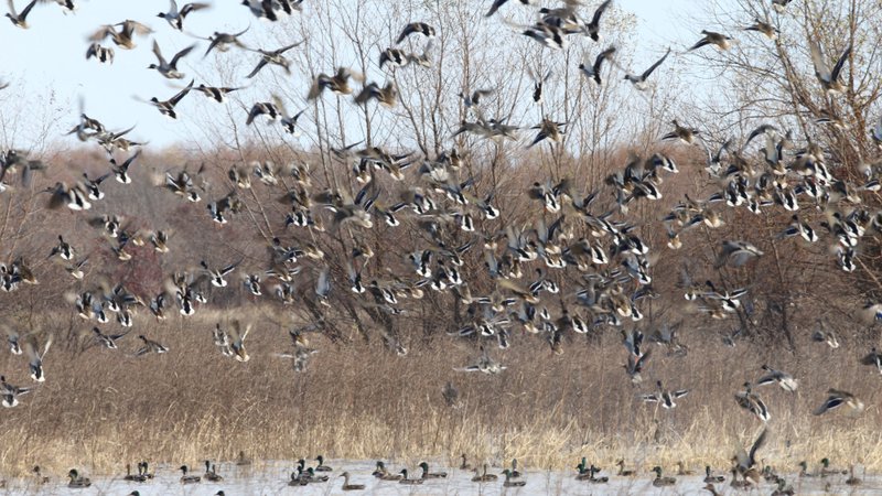
LITTLE ROCK – Arkansas duck hunters needed patience early in the 60-day season as the state endured record dry conditions, and now with water having arrived followed by an Arctic freeze, they wait for the ice to break. Forecasts say that should come later this week.
Much of Arkansas got its much-needed rain before Christmas, but a drop in temperature into the teens, if not single digits, just days before the new year dawned left little water that wasn’t frozen. Hence, it was hard to get to the ducks who were out on open water. Wednesday was expected to see a break in the below-freezing temps briefly, and the weekend could bring more rain and temperatures in the 40s to 50s for much of the state, according to the National Weather Service.
“It’s one of those years where you just have to scratch your head and wonder,” said Luke Naylor, the Arkansas Game and Fish Commission’s waterfowl program coordinator. “This is just a guess but I think there are going to be a lot of ducks around when things thaw out and it rains a little more this weekend, like they’re expecting.”
The AGFC is conducting its annual early January aerial survey of waterfowl this week. Naylor said, “Anecdotally, what a couple of observers who canvas about 75 percent of the Delta tell me, they are surprised at the lack of ducks they’ve seen. Now, it can be deceptive to counting when it is as cold as it is now. With a systematic survey like ours, it works best when habitat is available and duck distribution is fairly even. But with conditions like this, when the world is mostly frozen up, it leaves it patchy with ducks concentrated in just a few open spots. It’s still a little bit surprising they’re not seeing more of these larger concentrations.”
The survey results will be available in next week’s Waterfowl Report, and Naylor expects the estimate of ducks will increase from December’s totals. Arkansas’s December mallard numbers were in line with the past six years, but the overall duck count was down from past December totals. “It’s still tough conditions, and we’re still relatively dry,” he said. “We got that rain we needed in late December, and it flooded fields, but I would expect we have less water on the landscape than we had in past years and most of that is frozen up now. I expect a lot to change, if we get rain and above freezing for 48 hours.
“There are good concentrations of ducks in places. It’s just patchy now because of the ice.” The Arkansas River Valley west of Little Rock is typically a good spot when smaller water bodies are frozen up. Naylor said, “I would sure bet people are finding birds there.”
Some reports around the state have been good, even with frigid conditions. While the rivers are attracting ducks, fields continue drawing geese. A report to Ducks Unlimited’s waterfowl survey on Tuesday from North Little Rock said ducks were in peak numbers with 2,000 ducks and geese just off I-40. The reporter said he saw birds hitting fields near Lonoke and the “sky is almost black at some points.” And another reporter from Cotton Plant said, “Thought there was no chance, but open water adjacent to [the Cache River] worked. Took 10. Mallards and Teal. Lulls in between quick shooting. When they came in, they came in. Everything else was frozen.”
Northwest Arkansas provided a good report to DU as well. An observer in Prairie Grove noted 300-400 ducks at mid-morning Tuesday, down from the 700-800 he saw on Monday.
Northeast Arkansas
Earl Buss Bayou DeView WMA
Map | Water Gauge | Weather Report
Boaters should use caution while using the Thompson Tract boat run.
South Oliver GTR
Habitat: Mast production has been good.
Water Level: 70% flooded with a current gauge reading of 0.8 feet. There is a small amount of available water present within the natural slough on the north end of this GTR and south end of the North Oliver Tract.
Thompson Tract GTR
Habitat: Mast production has been good.
Water Level: 50% flooded with a current gauge reading of 0.6 feet.
Lake Hogue WRA
Habitat: A small amount of beneficial wetland plants is located along the east side of the lake.
Water Level: Normal pool level.
Big Lake WMA
Map | Water Gauge | Weather Report
When the Ditch 81 extension gauge near Manila (upstream of the Big Lake north-end control structure) reads 17.5 feet, water is beginning to come over the north levee degrade on Big Lake WMA. When the Ditch 81 Extension gauge reads 18.0 feet or higher, the water level on the WMA will rise quickly and hunters should exercise caution while on the area. Be aware of underwater logs in boat runs and hangers in trees.
North Woods GTR
Habitat: Mast production is good.
Water Level: Bo Dock gauge currently reads 235.9 feet, Target level is 235.5 feet with 100% flooded.
South Woods GTR
Habitat: Mast production is good.
Water Level: The 7-Mile gauge is currently at 235.2 feet. Target level is 234.5 feet with 100% flooded.
Simmons Field
Habitat: A good amount of millet, smartweed and sedge is present. Seed production is very good.
Water Level: 100%
St. Francis Sunken Lands WMA
Map | Water Gauge | Weather Report
Hunt Area
Habitat: Mast production is considered above average within the timber and floodways.
Water Level: Water levels in the huntable areas are dependent on St. Francis River flows. The water level at Oak Donnick is 212.15 feet, and approximately 100% of the huntable area is flooded.
Snowden WRA
Habitat: There is a small amount of beneficial wetland plants within the borrow areas.
Water Level: 0% flooded
Payneway WRA
Habitat: There are 70 acres of corn and millet planted throughout the WRA
Water Level: Pool A is at 0%. Pool B is at 0%. Pool C is at 5%. Pool D is at 5%.
Shirey Bay Rainey Brake WMA
Map | Water Gauge | Weather Report
Waterfowl hunters should be aware of hangers and submerged logs within the boat runs and GTRs. Please exercise caution when accessing the area. In addition, hunters should allow safe passage when parking vehicles along roadsides. Vehicles blocking access will be moved.
Adam Brake GTR
Habitat: High abundance of mast crop within the GTR.
Water Level: Water level is 239.8 feet msl with a target level of 240.0 msl. 90% flooded.
Rainey Brake GTR
Habitat: High abundance of mast crop within the GTR.
Water Level: 90% flooded.
Eagle Pond GTR
Habitat: High abundance of mast crop within the GTR.
Water Level: 100% flooded.
Phase III Moist-Soil Unit
Habitat: Fair wetland-type vegetation.
Water Level: 50% flooded.
Charles Crisp Moist-Soil Unit
Habitat: Fair wetland-type vegetation.
Water Level: 70% flooded.
Ward Field Moist-Soil Unit
Habitat: Good wetland-type vegetation.
Water Level: 100% flooded.
River Field Moist-Soil Unit
Habitat: High abundance of native wetland vegetation..
Water Level: 0% flooded.
Dave Donaldson Black River WMA
Map | Water Gauge | Weather Report
Waterfowl hunters should be aware of hangers and submerged logs within the boat runs and GTRs. Please exercise caution when accessing the area. Please remember to keep boats off the levees so AGFC personnel can access the area. Boats blocking access will be moved. Unattended trailers are not to be left overnight on parking areas.
Upper Island GTR
Habitat: Average abundance of mast crop within the GTRs.
Water Level: Water level is 269.35 feet msl. Target level is 269.5 feet msl. 95% flooded.
Lower Island GTR
Habitat: Average abundance of mast crop within the GTRs.
Water Level: Water level is 268.35 feet msl. Target level is 268.0 feet msl. 100% flooded.
Upper Reyno GTR
Habitat: Average abundance of mast crop within the GTRs.
Water Level: Water level is 267.14 feet msl. Target level is 266.9 feet msl. 100% flooded.
Lower Reyno GTR
Habitat: Average abundance of mast crop within the GTRs.
Water Level: Water level is 265.85 feet msl. Target level is 266.3 feet msl. 80% flooded.
Winchester GTR
Habitat: Average abundance of mast crop within the GTRs.
Water Level: Water level is 263.5 feet msl. Target level is 263.7 feet msl. 90% flooded.
East Central Arkansas
Sheffield Nelson Dagmar WMA
Map | Water Gauge | Weather Report
The Conway George units are available by applying for online permits. Permit hunts are on Saturday and Sunday. Please visit www.agfc.com for maps, special regulations, permit application and draw dates. Hunters should call the Wildlife Hotline at 800-440-1477 for current road closures.
Mud Slough GTR
Habitat: Good mast crop.
Water Level: 100%.
Apple Lake WRA
Habitat: Good mast crop.
Water Level: 100%.
Conway George Waterfowl Unit A
Habitat: Good stand of millet and native vegetation.
Water Level: 100%
Conway George Waterfowl Unit B
Habitat: Natural slough area with beneficial wetland plants
Water Level: 100%
Conway George Waterfowl Unit C
Habitat: Good stand of millet and native vegetation.
Water Level: 100%
Rex Hancock Black Swamp WMA
Map | Water Gauge | Weather Report
Hunters should call the Wildlife Hotline at 800-440-1477 for current road closures.
Main WMA
Habitat: Good mast crop.
Water Level: 50% and water levels are falling.
Wyeville Unit
Habitat: Good stand of millet and native vegetation.
Water Level: 100%
Steve N. Wilson Raft Creek Bottoms WMA
Map | Water Gauge | Weather Report
Unit A
Habitat: Excellent stand of millet and native vegetation.
Water Level: 100%
Unit B
Habitat: Excellent stand of millet and native vegetation.
Water Level: 100%
Unit C
Habitat: Good stand of native vegetation.
Water Level: 100%
Unit D (Youth Area)
Habitat: Good stand of millet and native vegetation.
Water Level: 100%
Unit E
Habitat: Good stand of millet and native vegetation.
Water Level: 100%
Unit F
Habitat: Good stand of millet and native vegetation.
Water Level: 60%
Unit G
Habitat: Fair stand of millet and native vegetation.
Water Level: 80%
Unit H (Mobility-impaired blind)
Habitat: Excellent stand of millet and native vegetation.
Water Level: 100%
Unit I
Habitat: Habitat conditions are poor.
Water Level: 60%
Unit J (Cypert Tract)
Habitat: Fair stand of native vegetation.
Water Level: 60%
Unit K (Cypert Tract)
Habitat: Excellent stand of millet and native vegetation.
Water Level: 65%
Unit L (Cypert Tract)
Habitat: Good stand of millet.
Water Level: 100%
Henry Gray Hurricane Lake WMA
Map | Water Gauge | Weather Report
Hunters should call the Wildlife Hotline at 800-440-1477 for current road closures.
North GTR
Habitat: Good mast crop.
Water Level: 55%
South GTR
Habitat: Good mast crop.
Water Level: 5%
Central Arkansas
Craig D. Campbell Lake Conway Reservoir
Map | Weather Report
Habitat and water levels are normal on both Pierce and Dix creeks.
Bell Slough WMA
Map | Weather Report
The Bell Slough GTR is primarily rainfall dependent with the exception of a limited amount of water that the AGFC can back in and catch from Palarm Creek.
Bell Slough GTR
Habitat: Moderate mast crop.
Water Level: 60%.
Palarm Creek WRA
Habitat: Millet was planted as a cover crop this year following disking within the moist-soil units.
Water Level: 100%
Holland Bottoms WMA
Hunt Area
Habitat: Good mast crop.
Water Level: 40%
Lake Pickthorne WRA
Habitat: Excellent.
Water Level: East cell is 100%. West cell is 100%.
Harris Brake WMA
Harris Brake Upper Unit
Habitat: Good mast crop mixed in with native vegetation.
Water Level: 100%
Harris Brake Lower Unit
Habitat: Good mast crop mixed in with native vegetation.
Water Level: 100%
Northwest Arkansas
Dardanelle WMA
McKennon Bottoms (half-day hunting)
Habitat: Good stand of native moist-soil vegetation.
Water Level: 100%.
Potter’s Pothole Hartman Waterfowl Unit (half-day hunting)
Habitat: Good stand of native moist-soil vegetation.
Water Level: 100%
Ozark Pool
Dyer Lake Cells (half-day hunting)
Habitat: Native vegetation.
Water Level: Dry.
Nimrod Lloyd Millwood WMA
Nimrod GTR
Good mast crop mixed in with native vegetation.
Water Level: 5%
Frog Bayou WMA
Unit 1
Habitat: Planted millet and native moist-soil vegetation.
Water Level: 95%
Unit 2
Habitat: Poor moist-soil response.
Water Level: 0% – rainfall dependent
Unit 3
Habitat: Primarily perennial vegetation.
Water Level: 95%
Unit 4
Habitat: Planted millet and native moist-soil vegetation.
Water Level: 95%
Unit 5
Habitat: Good moist-soil vegetation.
Water Level: 95%
Unit 6
Habitat: Good moist-soil response.
Water Level: 90%
Unit 7
Habitat: Some annual and perennial moist-soil vegetation.
Water Level: 90%
Petit Jean River WMA
Map | Water Gauge | Weather Report
Santa Fe GTR
Habitat: Good mast crop mixed in with native vegetation.
Water Level: 5%
Olin Cain Moist-Soil Unit
Habitat: 25% native vegetation with 75% bare ground due to ongoing waterfowl habitat enhancement projects.
Water Level: 30%
Black Lands Moist-Soil Unit
Habitat: 25% native vegetation with 75% bare ground due to ongoing waterfowl habitat enhancement projects.
Water Level: 10%
Slaty Crossing Moist-Soil Unit
Habitat: 25% native vegetation with 75% bare ground due to ongoing waterfowl habitat enhancement projects.
Water Level: 5%
Pullen Pond
Habitat: Native vegetation.
Water Level: 10%
Pond Creek GTR
Habitat: Good mast crop mixed in with native vegetation.
Water Level: 5%
Slaty Pond GTR
Habitat: Good mast crop mixed in with native vegetation.
Water Level: 5%
Black Lands Duck Area
Habitat: Good mast crop mixed in with native vegetation.
Water Level: 65%
Galla Creek WMA
Galla Creek GTR
Habitat: Natural vegetation, including a mixture of barnyard and smartweed.
Water Level: 100% – Staged flooding of the impoundment began on Nov. 27 and the waterfowl impoundment is flooded to full pool at this time.
Ed Gordon Point Remove WMA
Map | Weather Report
Water levels have continued to improve, and most waterfowl impoundments on Ed Gordon Point Remove WMA have some degree of water at this time. Limited pumping has continued, and impoundments will continue to be flooded as water levels in the creek allow. Duck use on the WMA has been minimal and hunter success has been poor.
Willow Island
Habitat: Natural vegetation.
Water Level: 35%
Little Hole
Habitat: Natural vegetation.
Water Level: 10%
Red Gate
Habitat: Natural vegetation.
Water Level: 90%
Pig Trough
Habitat: Natural vegetation.
Water Level: 80%
Cedar Ridge
Habitat: Natural vegetation.
Water Level: 100%
Duck Trap
Habitat: Natural vegetation.
Water Level: 30%
Salt Lick
Habitat: Natural vegetation.
Water Level: 75%
Bobby’s Pond
Habitat: Natural vegetation.
Water Level: 75%
Race Track
Habitat: Natural vegetation.
Water Level: 100%
Controversy Corner
Habitat: Natural vegetation.
Water Level: 90%
Remmel Marsh
Habitat: Natural vegetation.
Water Level: 90%
Mud Pond
Habitat: Natural vegetation.
Water Level: 0%
Turkey Pond
Habitat: Natural vegetation.
Water Level: 15%
Teeny Pond
Habitat: Natural vegetation.
Water Level: 0%
Southwest Arkansas
Sulphur River WMA
Map | Weather Report
The Henry Moore WRA is not flooded due to pump problems.
Mercer Bayou
Habitat: Fair.
Water Level: Drawn down for restoration project, boat ramps are closed.
Henry Moore WRA
Habitat: Closed to hunting.
Water Level: 0%.
Millwood Lake
Map | Water Gauge | Weather Report
Habitat: Habitat conditions are good.
Water Level: 259.54 feet msl
Dr. Lester Sitzes III Bois d’Arc WMA
Bois d’Arc Lake WRA
Habitat: Closed to hunting.
Water Level: 6 inches low
Red Slough WRA
Habitat: Closed to hunting.
Water Level: 30%
GTR
Habitat: Good mast production.
Water Level: 100%.
Little Grassy
Habitat: Habitat is fair.
Water Level: 50%
Ozan WMA
Habitat: Good
Water Level: 10%
Southeast Arkansas
Beryl Anthony Lower Ouachita WMA
Map | Weather Report
The WMA has fair hard mast production. At this time, the WMA’s water is located in the sloughs and oxbow lakes.
Freddie Black Choctaw Island WMA Deer Research Area
Map | Water Gauge | Weather Report
Habitat conditions are good. Flooding is river dependent. Click on the Water Gauge link above for current Mississippi River levels. Use extreme caution when boating in river.
Trusten Holder WMA
Map | Water Gauge | Weather Report
Habitat conditions are good. Flooding is river dependent. Click on the Water Gauge link above for current Arkansas River levels.
Seven Devils WMA
Hunt Area
Habitat: Habitat conditions are good, with an excellent acorn crop.
Water Level: This area is in a dry rotation year for flooding but some overbank flooding is occurring from Cut-Off Creek. Water level on 1-2-2018 was 130.4 feet msl.
Cut-Off Creek WMA
Hunt Area
Habitat: Habitat conditions are good, with an excellent acorn crop.
Water Level: Some water for hunting, not to full pool.
Pigeon Creek WRA
Habitat: Habitat conditions are good, excellent acorn crop.
Water Level: 100% flooded.
George H. Dunklin Jr. Bayou Meto WMA
Upper Vallier GTR
Habitat: Good
Water Level: 179.3 feet msl, full pool at 180 feet msl.
Lower Vallier GTR
Habitat: Good
Water Level: 179.2 feet msl, full pool at 179 feet msl. Use extreme caution when operating boats near water control structures.
Government Cypress GTR
Habitat: Good
Water Level: 179.2 feet msl, full pool at 179 feet msl.
Buckingham Flats GTR
Habitat: Good
Water Level: 100% flooded.
Temple Island GTR
Habitat: Good
Water Level: Pumping from Salt Bayou Ditch is delayed due to excessive road flooding.
Canon Brake
Habitat: Good
Water Level: 100% flooded. Use extreme caution when operating boats near water control structures.
Halowell WRA
Habitat: Excellent
Water Level: Staggered flooding of units.
Wrape Plantation WRA
Habitat: Excellent
Water Level: Staggered flooding of units.
Recent News

Arkansas Wildlife Weekly Fishing Report
Jul. 10, 2025
Lonoke aquaculturist named to AGFC
Jul. 10, 2025
Subscribe to Our Weekly Newsletter E-mails
Don’t miss another issue. Sign up now to receive the AGFC Wildlife Weekly Newsletter in your mailbox every Wednesday afternoon (Waterfowl Reports are published weekly during waterfowl season and periodically outside the season). Fishing Reports arrive on Thursdays. Fill in the following fields and hit submit. Thanks, and welcome!