Waterfowl Report for Feb. 1, 2017
ON 02-01-2017
Feb. 1, 2017
Keith Stephens
Chief of Communications
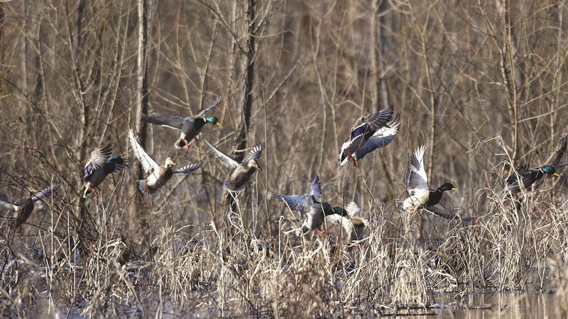
Youth Waterfowl Hunt Is Saturday
LITTLE ROCK – Arkansas’s duck season ended last weekend for most hunters, but hunters less than 16 years old will have one final chance to go afield during Saturday’s youth waterfowl hunt.
The second part of the state’s annual youth waterfowl hunt will take place from 30 minutes before sunrise until sunset. For the second year in a row, the Arkansas Game and Fish Commission established a two-part youth waterfowl hunt, with the first part taking place during the first split of the regular duck season in December 2016.
Youths 15 and under may hunt ducks, geese, coots and mergansers. Youths who have completed a hunter education course must be accompanied by a mentor 18 years or older, while youths who haven’t completed a hunter education course must be accompanied by a mentor 21 or older. Mentors may not hunt, but may call waterfowl.
Shooting hours and bag limits are the same as regular duck and goose seasons, but hunting is permitted from 30 minutes before sunrise until sunset on AGFC wildlife management areas. Sweet 16 WMA hunter-use permits aren’t required for youth hunters.
Northeast Arkansas
Earl Buss Bayou DeView WMA
Map | Water Gauge | Weather Report
Boaters should use caution while using the Thompson Tract boat run.
South Oliver GTR
Habitat: Mast production has been good.
Water Level: The area is 100% flooded with a current gauge reading of 1.7 feet.
Thompson Tract GTR
Habitat: Mast production has been good.
Water Level: The area is 100% flooded with a current reading of 1 foot.
Lake Hogue WRA
Habitat: A small amount of beneficial wetland plants is located along the east side of the lake.
Water Level: Normal pool level.
Big Lake WMA
Map | Water Gauge | Weather Report
When the Ditch 81 extension gauge near Manilla (upstream of the Big Lake north-end control structure) reads 17.5 feet, water is beginning to come over the north levee degrade on Big Lake WMA. When the Ditch 81 Extension gauge reads 18.0 feet or higher, the water level on the WMA will rise quickly and hunters should exercise caution while on the area. Be aware of underwater logs in boat runs and hangers in trees.
North Woods GTR
Habitat: Mast production is good.
Water Level: Bois d’Arc gauge currently reads 236.6 Target level is 235.5. 100% flooded.
South Woods GTR
Habitat: Mast production is good.
Water Level: The 7-Mile gauge is currently at 235.9 feet. Target level is 234.5 feet with 100% flooded.
Simmons Field
Habitat: A good amount of millet, smartweed and sedge is present. Seed production is good.
Water Level: 100%
St. Francis Sunken Lands WMA
Map | Water Gauge | Weather Report
Hunt Area
Habitat: Mast production is considered fair within the timber and floodways this year. However, there are some spotty areas among the higher elevations that have above average mast production.
Water Level: Water levels in the huntable areas are dependent on the St. Francis River. The water level at Oak Donnick is 208.71 feet with 70% of the huntable area flooded.
Snowden WRA
Habitat: There is a small amount of beneficial wetland plants within the borrow areas. Conditions are currently poor within the waterfowl rest area.
Water Level: 5%
Payneway WRA
Habitat: There is a small amount of beneficial wetland plants within the borrow areas. Conditions are considered below average within the waterfowl rest area.
Water Level: Pool A: 0% Pool B: 0% Pool C: 0% Pool D: 5%
Shirey Bay Rainey Brake WMA
Map | Water Gauge | Weather Report
Waterfowl hunters should be aware of hangers and submerged logs within the boat runs and GTRs. Please exercise caution when accessing the area. In addition, hunters should allow safe passage when parking vehicles along roadsides. Vehicles blocking access will be moved.
Adam’s Brake GTR
Habitat: Good mast crop within the GTR.
Water Level: Water level is 240.0 MSL with a target level of 240.0 MSL. 100% flooded.
Rainey Brake GTR
Habitat: Good mast crop within the GTR.
Water Level: 100%
Eagle Pond GTR
Habitat: Good mast crop within the GTR.
Water Level: 100%
Phase III Moist-soil Unit
Habitat: Average wetland-type vegetation.
Water Level: 80%
Charles Crisp Moist-soil Unit
Habitat: Average wetland-type vegetation.
Water Level: 100%
Ward Field Moist-soil Unit
Habitat: Good abundance of wetland-type vegetation.
Water Level: 100%
River Field Moist-soil Unit
Habitat: Good abundance of wetland-type vegetation.
Water Level: 90%
Dave Donaldson Black River WMA
Map | Water Gauge | Weather Report
Waterfowl hunters should be aware of hangers and submerged logs within the boat runs and GTRs. Please exercise caution when accessing the area. Please remember to keep boats off the levees so AGFC personnel can access the area. Boats blocking access will be moved. Unattended trailers are not to be left overnight on parking areas.
Upper Island GTR
Habitat: Average abundance of mast crop within the GTRs.
Water Level: Water level is 270.0. Target level is 269.5 MSL. 100% flooded.
Lower Island GTR
Habitat: Average abundance of mast crop within the GTRs.
Water Level: Water level is 268.7. Target level is 268.0 MSL. 100% flooded.
Upper Reyno GTR
Habitat: Average abundance of mast crop within the GTRs.
Water Level: Water level is 267.6. Target level is 266.9 MSL. 100% flooded.
Lower Reyno GTR
Habitat: Average abundance of mast crop within the GTRs.
Water Level: Water level is 266.45. Target level is 266.3 MSL. 100% flooded.
Winchester GTR
Habitat: Average abundance of mast crop within the GTRs.
Water Level: Water level is 263.7. Target level is 263.7 MSL. 100% flooded.
East Central Arkansas
Sheffield Nelson Dagmar WMA
Map | Water Gauge | Weather Report
The Conway George units are available by applying for online permits. Permit hunts are on Wednesday and Saturday. Please visit www.AGFC.com for maps, special regulations, permit application and draw dates. Hunters should call the Wildlife Hotline at 800-440-1477 for current road closures.
Mud Slough GTR
Habitat: Good mast crop.
Water Level: 90%
Apple Lake WRA
Habitat: Good mast crop.
Water Level: 100%
Conway George Waterfowl Unit A
Habitat: Good stand of millet and native vegetation.
Water Level: 100%
Conway George Waterfowl Unit B
Habitat: Natural slough area with beneficial wetland plants
Water Level: 100%
Conway George Waterfowl Unit C
Habitat: Good stand of millet and native vegetation.
Water Level: 100%
Rex Hancock Black Swamp WMA
Map | Water Gauge | Weather Report
Hunters should call the Wildlife Hotline at 800-440-1477 for current road closures.
Main WMA
Habitat: Good mast crop.
Water Level: 25%
Wyeville Unit
Habitat: Good stand of millet and native vegetation.
Water Level: 90%
Steve N. Wilson Raft Creek Bottoms WMA
Map | Water Gauge | Weather Report
Water conditions have improved. A permit draw will be held this weekend.
Unit A
Habitat: Excellent stand of native vegetation.
Water Level: 100%
Unit B
Habitat: Excellent stand of native vegetation.
Water Level: 100%
Unit C
Habitat: Excellent stand of native vegetation.
Water Level: 100%
Unit D (Youth area)
Habitat: Good stand of native vegetation.
Water Level: 100%
Unit E
Habitat: Good stand native vegetation.
Water Level: 100%
Unit F
Habitat: Good stand native vegetation.
Water Level: 40%
Unit G
Habitat: Habitat conditions are poor.
Water Level: 10%
Unit H (Mobility-impaired blind)
Habitat: Good stand of native vegetation.
Water Level: 100%
Unit I
Habitat: Conditions are poor.
Water Level: 15%
Henry Gray Hurricane Lake WMA
Map | Water Gauge | Weather Report
Hunters should call the Wildlife Hotline at 800-440-1477 for current road closures.
North GTR
Habitat: Good mast crop.
Water Level: 0%
South GTR
Habitat: Good mast crop.
Water Level: 0%
Southwest Arkansas
Sulphur River WMA
Map | Weather Report
The Henry Moore WRA is not flooded due to pump problems.
Mercer Bayou
Habitat: Habitat conditions are fair.
Water Level: The water level is normal.
Henry Moore WRA
Habitat: Closed to hunting.
Water Level: 0%.
Millwood Lake
Map | Water Gauge | Weather Report
Habitat: Habitat conditions are good.
Water Level: 259.87 MSL
Dr. Lester Sitzes III Bois d’ Arc WMA
Map | Weather Report
The water level in the GTR is still increasing.
Bois d’Arc Lake WRA
Habitat: Closed to hunting.
Water Level: Normal water level.
Red Slough WRA
Habitat: Closed to hunting.
Water Level: 100%
GTR
Habitat: Good mast production.
Water Level: 100%
Little Grassy
Habitat: Habitat is fair.
Water Level: 90%
Central Arkansas
Craig D. Campbell Lake Conway Reservoir
Map | Weather Report
Habitat and water levels are normal on both Pierce and Dix creeks.
Holland Bottoms WMA
Hunt Area
Habitat: Good mast crop.
Water Level: 10%
Lake Pickthorne WRA
Habitat: Excellent.
Water Level: East cell is 100%. West cell is 40%.
Harris Brake WMA
Harris Brake GTR
Habitat: Good mast crop.
Water Level: 100%
Bell Slough WMA
Map | Weather Report
Bell Slough GTR is mostly rainfall dependent with the exception of a limiited amount of water from Palarm Creek.
Bell Slough GTR
Habitat: Average mast crop.
Water Level: 95%
Palarm Creek WRA
Habitat: Fair seed production from natural vegetation.
Water Level: 100%
Southeast Arkansas
Beryl Anthony Lower Ouachita WMA
Map | Weather Report
The WMA has good soft and hard mast production. Currently, most of the WMA’s water is located in the sloughs and oxbow lakes.
Freddie Black Choctaw Island WMA Deer Research Area
Map | Water Gauge | Weather Report
Habitat conditions are good. There is variable flooding associated with the Mississippi River. The Mississippi River is at 25.8 feet with a predicted slight fall on the Arkansas City gauge to 25.7 feet by Sunday. Use extreme caution when boating in the river.
Trusten Holder WMA
Map | Water Gauge | Weather Report
Habitat conditions are good. Variable flooding on the WMA. The Arkansas River is at 26.37 feet and steady on the Pendleton gauge.
Seven Devils Swamp WMA
Hunt Area
Habitat: Habitat conditions are good, with an excellent acorn crop.
Water Level: 100% flooded.
Cut-Off Creek WMA
Hunt Area
Habitat: Habitat conditions are good, with an excellent acorn crop.
Water Level: 85% flooded. Some water in the wooded area. Water levels are rising slowly.
Pigeon Creek WRA
Habitat: Habitat conditions are good, with an excellent acorn crop.
Water Level: 100% flooded. Sporadic pumping as water levels allow.
Bayou Meto WMA
Rain is in the forecast this weekend. Water levels could change.
Upper Vallier GTR
Habitat: Good
Water Level: Water level is at 180.0 feet MSL. Full pool is 180 feet MSL.
Lower Vallier GTR
Habitat: Good
Water Level: Water level is at 179.8 feet MSL. Full pool is 179 feet MSL. Use caution and watch for strong current near water control structures.
Government Cypress GTR
Habitat: Good
Water Level: Water level is at 179.8 feet msl. Full pool is 179 feet msl.
Buckingham Flats GTR
Habitat: Good
Water Level: 100% flooded
Temple Island GTR
Habitat: Good
Water Level: 100% flooded.
Canon Brake
Habitat: Good
Water Level: 100% flooded. Use caution and watch for current near water control structure.
Halowell WRA
Habitat: Excellent
Water Level: The final unit is flooding.
Wrape Plantation WRA
Habitat: Excellent
Water Level: The final unit is flooding.
Northwest Arkansas
Dardanelle WMA
Johnson County WRA
Habitat: Habitat is fair.
Water Level: 80%
McKennon Bottoms
Habitat: Habitat is very poor.
Water Level: 90%
Potter’s Pothole Hartman Waterfowl Unit
Habitat: Habitat is poor.
Water Level: 100%
Ozark Pool
Dyer Lake Cells
Habitat: Millet and moist soil.
Water Level: Units 1 and 2 are at 50% of capacity.
Lloyd Millwood Nimrod WMA
Nimrod GTR
Habitat: Good mast crop.
Water Level: 0%
Frog Bayou WMA
Unit 1
Habitat: Native millet and smartweed.
Water Level: 100%
Unit 2
Habitat: Habitat is poor.
Water Level: 0%
Unit 3
Habitat: Native millet and smartweed.
Water Level: 100%
Unit 4
Habitat: Native moist soil and planted millet.
Water Level: 80%
Unit 5
Habitat: Native moist soil and planted millet.
Water Level: 80%
Unit 6
Habitat: Good stand of smartweed and native millet.
Water Level: 50%
Unit 7
Habitat: Planted millet
Water Level: 80%
Galla Creek WMA
Galla Creek GTR
Habitat: Natural vegetation inluding a mixutre of barnyard and smartweed.
Water Level: 100%. The waterfowl impoundment is now at capacity.
Petit Jean River WMA
Map | Water Gauge | Weather Report
Santa Fe GTR
Habitat: Good mast crop.
Water Level: 0%
Olin Cain Moist-soil Unit
Habitat: This area contains a good stand of desirable native vegetation throughout, with Japanese millet planted in the ditches.
Water Level: 60%
Black Lands Moist-soil Unit
Habitat: This area contains a good stand of desirable native vegetation throughout, with Japanese millet planted in the ditches.
Water Level: 100%
Slaty Crossing Moist-soil Unit
Habitat: This area contains a good stand of desirable native vegetation throughout.
Water Level: 100%
Pullen Pond
Habitat: This area contains a poor stand of desirable native vegetation throughout, with Japanese millet planted along the main ditch.
Water Level: 0%
Pond Creek GTR
Habitat: Good mast crop.
Water Level: 0%
Slaty Pond GTR
Habitat: Good mast crop.
Water Level: 30%
Black Lands Duck Area
Habitat: Good mast crop. This area also contains a good stand of desirable native vegetation and Japanese millet throughout.
Water Level: 75%
Ed Gordon Point Remove WMA
Map | Weather Report
Conditions have not changed from lthe previous report. Half of the units now have some water. Duck use on the area remains low and hunter success has been poor.
Willow Island
Habitat: Natural vegetation.
Water Level: 100%
Little Hole
Habitat: Natural vegetation.
Water Level: 15%
Red Gate
Habitat: Natural vegetation.
Water Level: 85%
Pig Trough
Habitat: Natural vegetation.
Water Level: 85%
Cedar Ridge
Habitat: Natural vegetation.
Water Level: 90%
Duck Trap
Habitat: Natural vegetation.
Water Level: 25%
Salt Lick
Habitat: Natural vegetation.
Water Level: 30%
Bobby’s Pond
Habitat: Natural vegetation.
Water Level: 80%
Race Track
Habitat: Natural vegetation.
Water Level: 100%
Controversy Corner
Habitat: Natural vegetation.
Water Level: 75%
Remmel Marsh
Habitat: Natural vegetation.
Water Level: 100%
Mud Pond
Habitat: Natural vegetation.
Water Level: 0%
Turkey Pond
Habitat: Natural vegetation.
Water Level: 25%
Teeny Pond
Habitat: Natural vegetation.
Water Level: 15%
Recent News

Arkansas Wildlife Weekly Fishing Report
Jul. 10, 2025
Lonoke aquaculturist named to AGFC
Jul. 10, 2025
Subscribe to Our Weekly Newsletter E-mails
Don’t miss another issue. Sign up now to receive the AGFC Wildlife Weekly Newsletter in your mailbox every Wednesday afternoon (Waterfowl Reports are published weekly during waterfowl season and periodically outside the season). Fishing Reports arrive on Thursdays. Fill in the following fields and hit submit. Thanks, and welcome!