Wattensaw WMA Habitat Project
Mike Freeze Wattensaw Wildlife Management Area Habitat Project
Current and prescribed forest management is occurring on sites categorized utilizing the Arkansas Wildlife Action Plan land classification system for terrestrial habitats. Treatment sites in this area are classified as Lower Mississippi Flatwoods Woodland & Forest, Lower Mississippi Alluvial Plain Grand Prairie, or Cultivated Forest. This system is composed of forests, prairies and woodlands on Pleistocene terraces in the Mississippi Alluvial Plain ecoregion. It occurs primarily west of Crowley’s Ridge on Pleistocene glacial outwash deposits in Arkansas and Missouri, and on Macon Ridge in Louisiana and Arkansas. The sites are above modern floodplains, but have poor internal drainage and are flat with poor runoff, leading to very wet conditions in winter and spring. They also often have a claypan that restricts both internal drainage and, later in the year, water availability. Therefore they are very wet in the winter/spring and very dry in the summer, a moisture regime termed hydroxeric (wet-dry). Because of this moisture regime, the communities are variable, ranging from willow oak flats to post oak flats to natural prairie openings. In the 1940s, the Arkansas Game and Fish Commission produced a wildlife habitat map of Arkansas in which these sites were classified as “terrace hardwood forests”. These communities have a large variety of upland and lowland tree species, ranging from post oak to overcup oak in a small area. Such species diversity is the result of natural regeneration of species with dramatically different moisture tolerances on the same site in dry and wet years on these hydroxeric sites. Fire was the primary dynamic influence on forest density and species composition and resulted historically in relatively open stand structure with diverse plant communities on the ground. Because the sites are above current floodplains and susceptible to being drained, they have been cleared across the landscape at an even greater rate than nearby floodplain forests.
Past Activities
During the early 1980’s non-native loblolly pine strips were planted within non forested areas in an effort to reduce the size of individual non forested areas. Establishment of these strips were intended to provide short term wildlife benefit due to their rapid growth and not intended to be managed long term due to the species being non-native to the site. These planted strips offered visual screens, travel corridors and early successional habitat, but at the expense of a more natural patchwork of open grassland, open woodlands and forest.
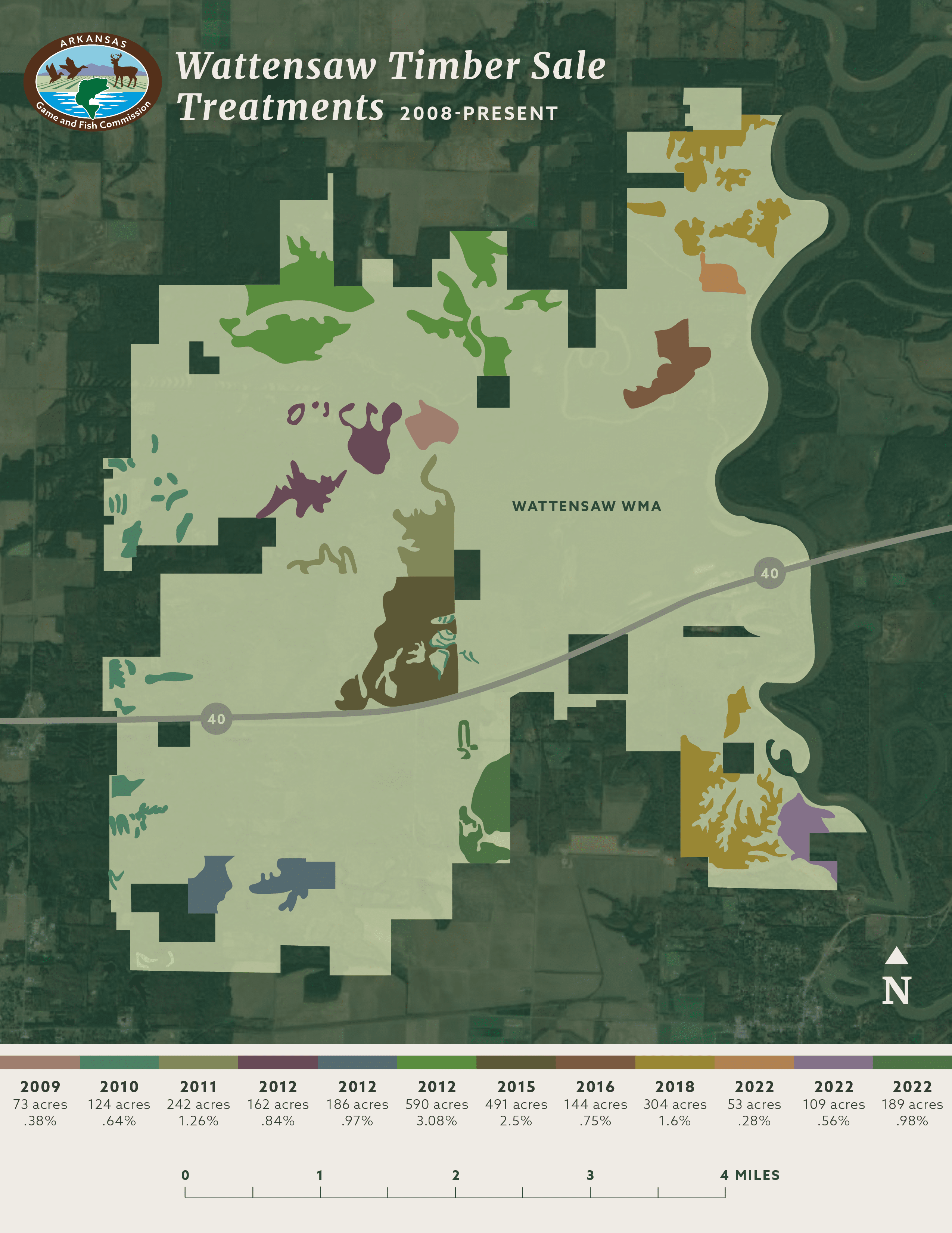
Current management and future planned management will mark the third entry for forest management on many of these stands. Initial management was performed on 497 acres in 1986 and the second entry in 2004 consisted of forest management on 242 acres and included a 75% removal of non-native loblolly pines.
Current Conditions
Currently these strips have outgrown their usefulness for wildlife. The dominant species are loblolly pine in the overstory with sweetgum, elm, and various oak species in the midstory. Basal area in the strips is near 100 sq. ft/acre on average and canopy closure is near 80-90%. This density allows little to no sunlight to reach the understory and leaves sparse forage or cover for wildlife within the strips.
Overall Management Objectives
Forest Inventory/Health Assessment
Routine forest inventories and forest health assessments are performed on all AGFC-owned forest lands by Registered Foresters. Forest data is collected at evenly distributed, spatially referenced, permanent plots. Plot level data collected consists of primarily three levels of measurement. First is the forest structure in which canopy closure, mid-story density, and understory density is measured in order to determine ground level shading. Second is variable radius tree level data collection from the plot center. Information such as species, diameter, forest product, crown classification and individual tree health is recorded. The third level of data collection is along a sub-plot at the plot center. This is a fixed radius plot in which all regeneration is tabulated by species. Forest inventory and forest health data is used to develop forest management plans, assess overall forest health and evaluate effectiveness of management activities.
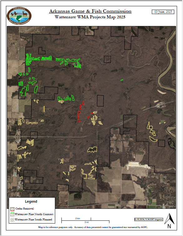
Active Forest Management Projects
- Regeneration Harvest 192 acres Cultivated Forest
- Commercial Thinning 23 acres Cultivated Forest
- WSI Cut and Drop (Cedar) 20 acres Lower Mississippi Flatwoods Woodland & Forest
Regeneration harvest is being utilized to remove non-native loblolly pine strips. Long term site management includes recruitment of native fire tolerant species maintained in more open conditions.
Commercial thinning will be utilized in pine blocks larger than 10 acres in size to reduce total land use change and provide intermediate habitat while desirable native species establish. These stands will be cut to 40 ba/acre and monitored for adequate recruitment of desirable hardwood species. Once desirable regeneration is established the remaining pine will be removed.
Prescribed fire will be the primary management tool for maintaining desired forest conditions. Return interval and seasonality will vary depending on vegetative responses and will vary from 2-5 years between burns.
WSI by Cut and Drop will be utilized to remove undesirable cedar that was established due to an infrequent fire regime in previous decades. Treatment areas will be burned in the dormant season within 2 years post management to remove the slash and allow desirable species to re-establish.
Prescribed Forest Management Projects
- Regeneration Harvest 194 acres Cultivated Forest
- Commercial Thinning 27 acres Cultivated Forest
Regeneration harvest will be utilized to remove non-native loblolly pine strips. Long term site management includes recruitment of native fire tolerant species maintained in more open conditions.
Commercial thinning will be utilized in pine blocks larger than 10 acres in size to reduce total land use change and provide intermediate habitat while desirable native species establish. These stands will be cut to 40 ba/acre and monitored for adequate recruitment of desirable hardwood species. Once desirable regeneration is established the remaining pine will be removed.
Prescribed fire will be the primary management tool for maintaining desired forest conditions. Return interval and seasonality will vary depending on vegetative responses and will vary from 2-5 years between burns.
Species of Greatest Conservation Need (SGCN)
The Arkansas Wildlife Action Plan identifies species of greatest conservation need for Arkansas. SGCN are species that are rare, declining, or for which we have very little information on population status.
The identification of SGCN is part of a process to identify species and groups of species that will be the focus of programs and projects supported by federal funding under the State Wildlife Grant program. Federally-listed species that occur in Arkansas are included on the list of SGCN and addressed by this strategy. However, such species are eligible for funding by sources other than State Wildlife Grants.
SGCN known from Mike Freeze Wattensaw WMA:
- Little Brown Bat
- Southeastern Bat
- Rafinesque’s big-eared bat
- Chimney Swift
- Northern Bobwhite
- Bell’s Vireo
- Wood Thrush
Resources
Below you can find more information regarding the closure of these areas and the standards that demonstrate the agency’s commitment to responsible forestry and building better habitats across our natural state:
Below you can find more information regarding this project: