Hurricane Lake WMA (Habitat Project & Glaise Creek)
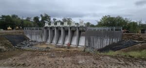
- On June 25, footage was released of the new water control structure releasing water from the system. The overshot gates work in allowing debris to flow over the top, with the automation allowing it to continuously adjust to the set elevation. Once the artificial “weir” is removed, the system will function more naturally in controlling the flow of water. View the videos below:
- On March 24, the gate at Mitchell Corner Access was opened to vehicular traffic. The gate to Big Hurricane Lake remains closed while road maintenance is being performed.
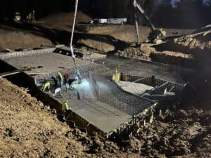
- On December 12, the project was estimated to be 98% done and has almost reached completion. The new structure will be fully operation once electrical work is completed.
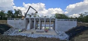
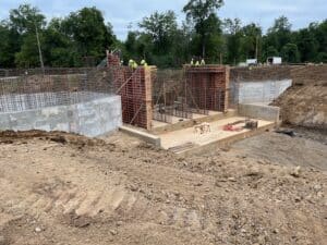
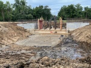
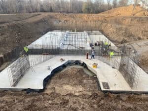
- On August 13, these photos were taken of the progress made. The first two gate divider walls are scheduled to pour 8/16.
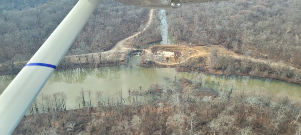
- On January 4, this aerial photo of the site was taken.
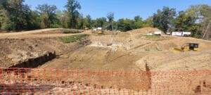
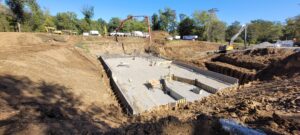
- On Dec. 13, about 1/3 of the new water control structure has been completed. Several obstacles have been overcome and the contractor is onsite and taking advantage of the dry winter. Click the photos below to see the progress of the structure.
Hurricane Lake WMA Current Management Summary
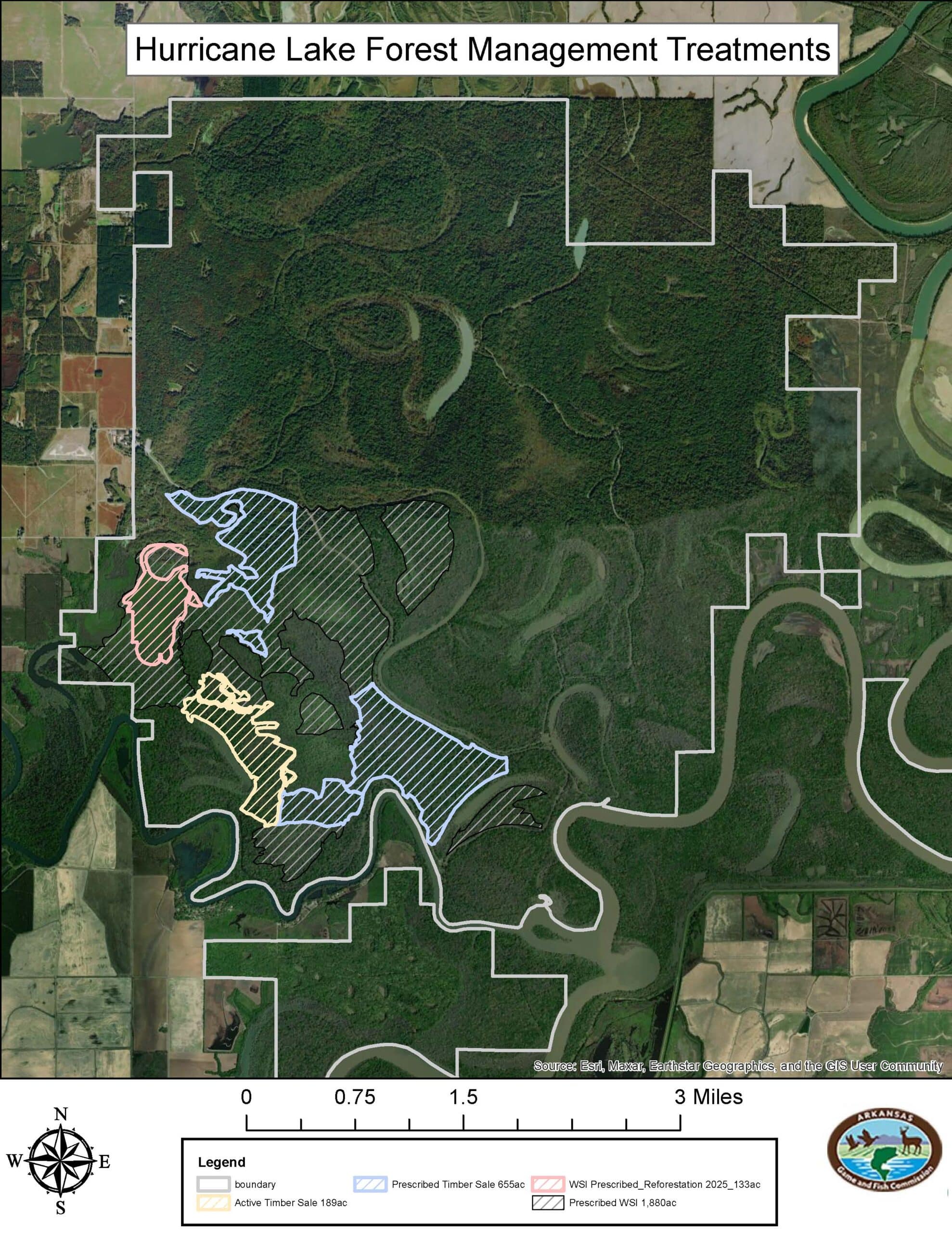
South GTR
Current forest management is occurring on sites categorized utilizing the Arkansas Wildlife Action Plan land classification system for terrestrial habitats. Treatment sites in this area are classified as Lower Mississippi River High Bottomland Forest, Lower Mississippi River Riparian Forest, Lower Mississippi River Low Bottomland Forest, and Lower Mississippi River Bottomland Depression.
High bottomland forests are often temporarily flooded in older Holocene point bars and natural levees, with flooding less frequent than every 5 years. Wetland functions are primarily driven by precipitation and are classed as hardwood flats in a hydrogeomorphic classification. They are flooded less frequently than adjacent riparian floodplains. Forests are often dominated by species such as cherrybark oak and swamp chestnut oak.
Riparian forests are composed of riverfront associations, generally temporarily flooded on point bars and natural levees adjacent to the river that formed them, with flooding more frequent than every 5 years, by flowing water directly from the stream. They are classed as Low Gradient Riverine Overbank wetlands in a hydrogeomorphic classification. Flooding is of longer duration than on high bottomlands that are typically temporarily flooded. Soils are typically sandier than those of low bottomlands. Giant cane is a common understory species with sycamore, pecan, and nuttall oak being the characteristic dominant species.
Low bottomland forests are usually seasonally flooded in back swamps, with flooding more frequent than every 5 years, usually more frequently than every two years, generally by still water that may be impounded behind natural levees, and are classed as Low Gradient Riverine Backwater wetlands in hydrogeomorphic classifications. Low bottomlands occur along the Mississippi River and its tributaries in the Mississippi Alluvial Plain Ecoregion. Prolonged flooding dominates this system, and its duration is greater than in the adjacent Mississippi River Riparian Forest. Overcup oak and willow oak are the characteristic dominant species. Soils are clayey with poor internal drainage. Historically, regeneration was through small treefall gaps or large tornado tracks.
Bottomland depressions represent semi permanently flooded to saturated depressional areas. They are typically created by changes in channels of meandering streams and depending on time since abandonment by the river, character may vary from large oxbow swamps to small saturated swales. Bald cypress and overcup oak are the characteristic dominant species.
South GTR
Nuttall oak, overcup oak, and green ash are the dominant species by order of prevalence. Recent forest health data indicate red oak species are exhibiting moderate stress throughout all elevations, with heavy stress being expressed the greatest at elevations below 192 msl and extensive amounts of red oak mortality below 191 msl. Swamp privet, hackberry, overcup oak, and green ash are the most prevalent sub merchantable species. Wind throw and mortality of dominant and co-dominant trees due to water stress have provided favorable conditions for limited regeneration of nuttall oak and willow oak.
Silvicultural techniques will be the primary tools utilized to manipulate forest structure and species composition in order to provide favorable conditions for red oak regeneration and achieve Desired Forest Conditions (DFCs), which will result in increased cover and species diversity on the ground. DFCs are predetermined forest metrics including canopy closure, mid-story density, species composition and basal area that are appropriate for a specific land classification. The desired conditions vary by land classification and are designed to ensure forest sustainability and diverse species composition appropriate for the site.
South GTR – Timber harvest in areas of moderate to heavy water stress and reforestation in areas of high Red Oak mortality
- Variable retention harvest – 189 acres
South GTR
- Variable retention harvest – 655 acres
- WSI to site prep for planting of nuttall oak -133 acres
- Hand plant 297 acres of nuttall oak
- WSI on 1880 acres. 1,375 acres of this is pending regeneration response after the variable retention harvest to reduce competition on desirable regeneration.
The Arkansas Wildlife Action Plan identifies species of greatest conservation need for Arkansas. SGCN are species that are rare, declining, or for which we have very little information on population status.
The identification of SGCN is part of a process to identify species and groups of species that will be the focus of programs and projects supported by federal funding under the State Wildlife Grant program. Federally-listed species that occur in Arkansas are included on the list of SGCN and addressed by this strategy. However, such species are eligible for funding by sources other than State Wildlife Grants.
SGCN known from Hurricane Lake WMA:
- Pink Mucket
- Rafinesque’s Big-Eared Bat
- Mooneye
- Southeastern Bat
- Paddlefish
Information for Area Closure
BALD KNOB – The road leading to Big Hurricane Lake in the Henry Gray Hurricane Lake WMA was closed Tuesday, Sept. 27, and will not reopen until completion of work on a new Glaise Creek water-control structure. The structure is essential to renovating bottomland hardwood forests within the WMA, which saw substantial die-offs beginning in 2018.
The road closure will begin at the intersection of Glaise Creek Road and Hurricane Lake Road (where Glaise Creek and Whirl Lake meet). The latitude/longitude of the starting point for the closure are 35.20015 degrees North, 91.43331 degrees West. This will be the only section under construction but will be impassable until work is finished on the new structure. Areas accessed through Hurricane Lake Road north of this construction also will be inaccessible by vehicle during the construction.
The WMA has already seen major changes to water management within the previous greentree reservoirs, and a substantial project last year reestablished many drainage points along Mallard Pond Road on the south side of the WMA to allow water to flow to and from the Little Red River when conditions allowed. This next step of the renovation will widen and replace the existing pinch point at Glaise Creek to enable more flow through the WMA to the White River downstream.
“You have to start at the bottom and move up the system,” Jason “Buck” Jackson, AGFC statewide wetlands program coordinator, said. “The water has to have a place to exit, then you have to continue finding those pinch points.”
Advanced LiDAR mapping and surveying revealed many shortcomings of the WMA’s current drainage that will need substantial infrastructure changes to remedy.
“We estimate that at least 10,000 cubic feet per second of water needed to flow through this point for the WMA to drain effectively,” Jackson said. “The current structure was well short of that capacity.”
The Glaise Creek Project is work undertaken in a partnership between AGFC and Ducks Unlimited to improve water management in Henry Gray Hurricane Lake WMA to restore the habitat and set the stage for sustainable long-term management. A contractor hired by DU is working on the project, which received a federal North American Wetlands Conservation Act grant to help offset some of the renovation costs. The AGFC also has contributed more than $3 million to the Glaise Creek renovation, with the recent approval of a $1 million budget transfer within the AGFC’s existing budget to complete the construction and installation of the new water-control structure.
“We’re about to pour 1,500 cubic yards of concrete starting at the bottom of Glaise Creek,” Jackson said of the new water-control structure. “It’s a massive structure. After all, it has to handle 120 feet of water up to 13 feet deep. That’s a lot of force to withstand. It’s going to take some time to complete. And the current site conditions are perfect now to begin.”
Resources
Below you can find more information regarding the closure of these areas and the standards that demonstrate the agency’s commitment to responsible forestry and building better habitats across our natural state:
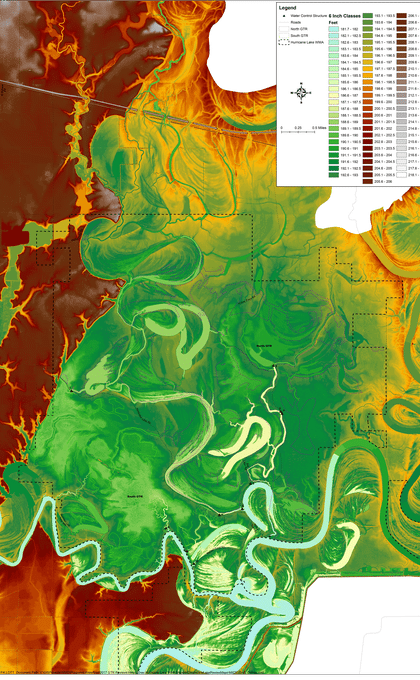
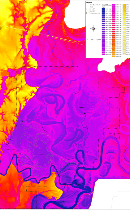
Click the images below to see the water levels for this site