Earl Buss Bayou DeView WMA (Oliver Tract)
Latest Earl Buss Bayou DeView WMA (Oliver Tract) Updates:
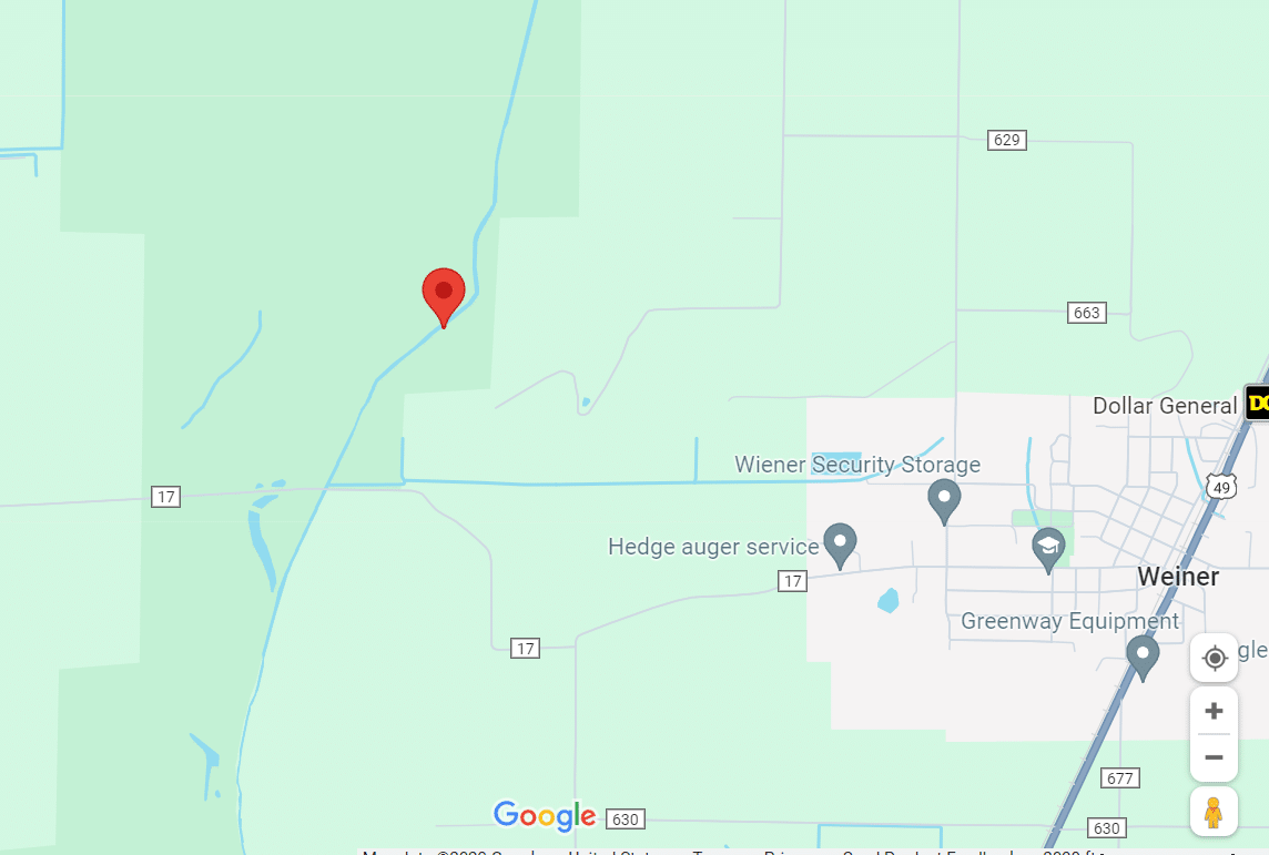
- On March 4, 2026 an updated map was created for a presentation. Click here to view the map.
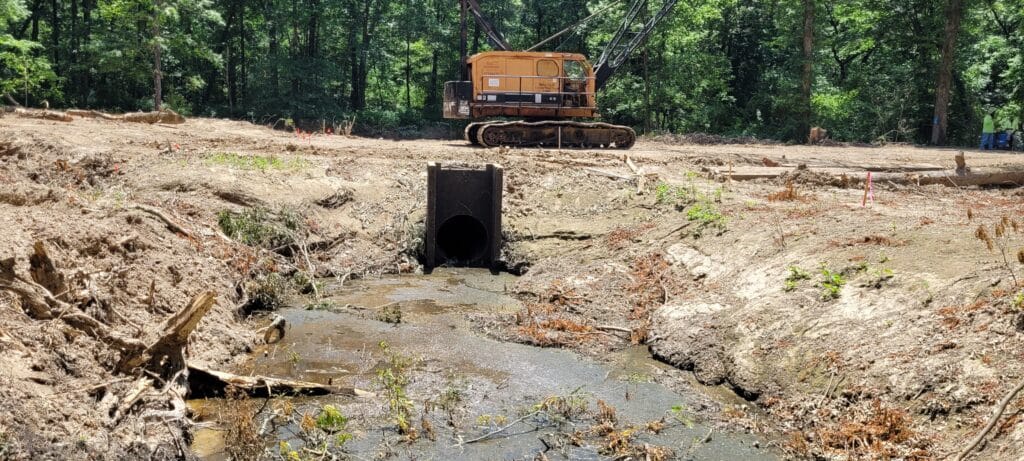
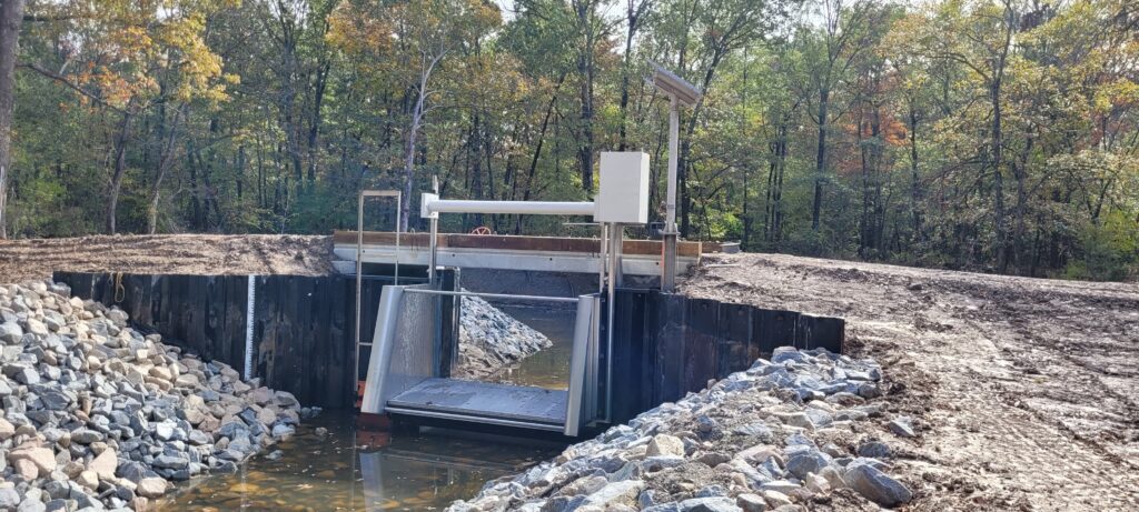
- On Dec. 12, 2024 photos were provided of the levee work, spillways and smaller water control structures to complement the large overshots.
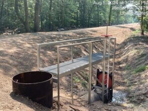
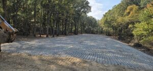
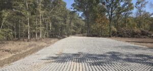
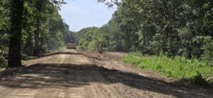
- On Dec. 13, 2023 Phase 1 was completed on both the Thompson and South Oliver tracts. Phase 2 has been awarded and the contractor is ordering and gathering the materials to work on spillways, levee work, and smaller water control structures.
Click the pictures below to view Phase 1 before and after.
Information for Area Closure
Renovation in full swing at Earl Buss Bayou DeView WMA
Greentree reservoirs in Earl Buss Bayou DeView Wildlife Management Area in Poinsett County also saw the beginning of major renovation work planned over two phases. Phase one began in early June with heavy machinery bringing in modern infrastructure to be installed in the WMA’s Thompson Tract GTR.
Two large (15- and 18-feet wide) electrically powered metal overshot gates that can be operated remotely will replace two outdated 4-foot structures that used a screw gate and aluminum “boards” to retain water. The new water-control structures are going in at the Thompson Tract, in the middle of the WMA, and the South Oliver greentree reservoir, on the property’s south end. Phase Two, most likely beginning next summer, will add more water-control structures, rebuild levees and add spillways that will let spring and summer floodwater flow through the WMA more efficiently.
Much like on Hurricane Lake WMA, the work at Bayou Deview was partially funded through Ducks Unlimited and the North American Wetlands Conservation Act.
Some forest management work also has taken place at Bayou Deview. The WMA did not see as much tree death as other areas, and a good amount of red oaks remain in the greentree reservoirs. The canopy is closed and needs to be opened to allow young red oaks to become established.
Bayou DeView is channeled in northeast Arkansas, unlike the winding parts of Bayou DeView found near Interstate 40 near Brinkley. The bayou’s periodic flooding can cover nearby roadways over 1 foot deep. Spring floods are going to happen, but biologists have learned that moving water is much less damaging than stagnant water held back by poor drainage.
Jason Carbaugh, an AGFC regional biologist based in Jonesboro, said, “It’s natural for the area to flood in spring. When the 2021 duck season closed, I started pulling boards (after two large snowfalls) in February. Bayou DeView flooded and drained five times from March through July. This past spring it flooded (and drained) four times after duck season closed. These new structures that we’re putting in, as well as renovating levees and putting in large spillways, will allow those natural spring floods to flow through these WMAs at a much more efficient rate, improving forest health and regenerating red oak communities.”
Current Forest Management Summary
Current forest management is occurring on sites categorized utilizing the Arkansas Wildlife Action Plan land classification system for terrestrial habitats. Treatment sites in this area are classified as Lower Mississippi River Low Bottomland Forest.
Low bottomland forests are usually seasonally flooded in back swamps, with flooding more frequent than every 5 years, usually more frequently than every two years, generally by still water that may be impounded behind natural levees, and are classed as Low Gradient Riverine Backwater wetlands in hydrogeomorphic classifications. Low bottomlands occur along the Mississippi River and its tributaries in the Mississippi Alluvial Plain Ecoregion. Prolonged flooding dominates this system, and its duration is greater than in the adjacent Mississippi River Riparian Forest. Overcup oak and willow oak are the characteristic dominant species. Soils are clayey with poor internal drainage. Historically, regeneration was through small treefall gaps or large tornado tracks.
South Oliver Tract Green Tree Reservoir
Overcup Oak, Willow Oak, Mockernut Hickory, Green Ash, and Cherrybark Oak are the dominant species of prevalence. Recent forest health data indicate red oak species are exhibiting moderate stress throughout the entire stand. Wind throw and mortality of dominant and co-dominant trees due to water stress have provided favorable conditions for limited regeneration of Nuttall Oak and Willow Oak.
Thompson Tract Green Tree Reservoir
Mockernut Hickory, Cherrybark Oak, Sweetgum, Overcup Oak, Willow Oak, and Green Ash are the dominant species. Recent forest health data indicate red oak species are exhibiting moderate to heavy stress throughout the entire stand. Wind throw and mortality of dominant and co-dominant trees due to water stress have provided favorable conditions for limited regeneration of Nuttall Oak and Willow Oak.
Forest Inventory/Health Assessment
Routine forest inventories and forest health assessments are performed on all AGFC-owned forest lands by Registered Foresters. Forest data is collected at evenly distributed, spatially referenced, permanent plots. Plot level data collected consists of primarily three levels of measurement. First is the forest structure in which canopy closure, mid-story density, and understory density is measured in order to determine ground level shading. Second is variable radius tree level data collection from the plot center. Information such as species, diameter, forest product, crown classification and individual tree health is recorded. The third level of data collection is along a sub-plot at the plot center. This is a fixed radius plot in which all regeneration is tabulated by species. Forest inventory and forest health data are used to develop forest management plans, assess overall forest health and evaluate effectiveness of management activities.
Silvicultural techniques will be the primary tools utilized to manipulate forest structure and species composition in order to provide favorable conditions for red oak regeneration, improve forest health and achieve Desired Forest Conditions (DFCs), which will result in increased cover and species diversity on the ground. DFCs are predetermined forest metrics including canopy closure, mid-story density, species composition and basal area that are appropriate for a specific land classification. The desired conditions vary by land classification and are designed to ensure forest sustainability and diverse species composition appropriate for the site.
- Thompson Tract Variable Retention Harvest- 70 acres (to be performed in 2025-2026)
- South Oliver Tract Variable Retention Harvest – 277 acres (to be performed in 2025-2026)
- Forest Inventory/Health Assessment- 179 acres (to be performed in 2025-2026)
The Arkansas Wildlife Action Plan identifies species of greatest conservation need for Arkansas. SGCN are species that are rare, declining, or for which we have very little information on population status.
The identification of SGCN is part of a process to identify species and groups of species that will be the focus of programs and projects supported by federal funding under the State Wildlife Grant program. Federally-listed species that occur in Arkansas are included on the list of SGCN and addressed by this strategy. These species are also eligible for funding through cooperative endangered species act Section 6 grants.
SGCN known from Earl Bass Bayou DeView WMA:
- Northern Long-Eared Bat (Myotis septentrionalis)
- Rusty Blackbird (Euphagus carolinus)
- Loggerhead Shrike (Lanius ludovicianus)
- Chimney Swift (Chaetura pelagica)
- Swainson’s Warbler (Limnothlypis swainsonii)
- Cerulean Warbler (Setophaga cerulea)
- Black-crowned Night-Heron (Nycticorax nycticorax)
- Wood Thrush (Hylocichla mustelina)
Resources
Below you can find more information regarding the closure of these areas and the standards that demonstrate the agency’s commitment to responsible forestry and building better habitats across our natural state: