Lake Chicot receives new plumbing for fish
ON 06-14-2017
June 14, 2017
Randy Zellers
Assistant Chief of Communications
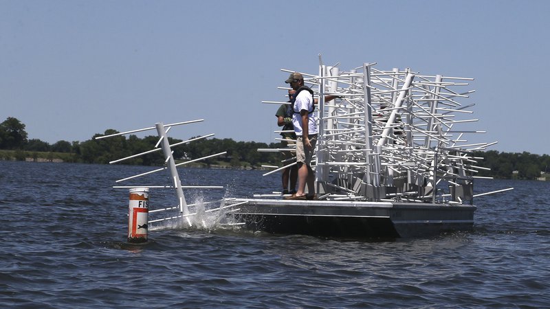
Arkansas Game and Fish Commission Fisheries staff have spent the last three weeks chopping and fitting PVC pipes to improve Lake Chicot, but they aren’t concerned with how the water is flowing. The PVC is being used to create complex fish attractors to sink at strategic points in the lake to offer anglers places where fish are likely to congregate.
Nearly 500 fish-attractors were placed at 26 locations across the lake during the project. Some were placed in the same locations as previous fish attractors, while others were used to create new sites for anglers to enjoy.
Mike Sundberg, AGFC fisheries biologist in Monticello, says that while PVC lacks some of the nooks and crannies of more complex brush, it is likely to last up to 20 years, and was the best option for Chicot because of the lack of available shoreline trees on public land.
“Many habitat projects the AGFC conducts are done using trees and brush from the land surrounding the lake,” Sundberg said. “But there’s hardly any public property on Lake Chicot to get the woody material. PVC is very light, so we can make all our components, haul them to the lake, assemble them on shore and place them in the water much more efficiently than trying to relocate large amounts of woody cover.”
Sundberg says the project is one of two large-scale aquatic habitat placement projects being conducted this year.
“We always are working to improve the aquatic habitat in our districts in some way, but this project is special,” said Sundberg. “We have teams of biologists coming down to work together and really make a lot of habitat in a short time.”
Diana Andrews, AGFC fisheries supervisor for southeast Arkansas, says the work being done in this project’s three-week timespan would take four to five months if it were left solely in the hands of the staff available in her region.
“We build habitats and sink them, but we have other duties that prevent us from making the headway we can with this sort of effort,” Andrews said. “We can gather up materials and get an assembly line going to make quick work of the cutting and drilling components, then have teams sinking attractors while others assemble them for the next run.”
Biologists placed 20 7-foot tall structures at 15 old fish-attractor locations, as well as 15 5-foot structures around the four public fishing piers on the lake. An additional 129 5-foot structures were distributed among seven new locations. The locations will not be marked with traditional buoys or signs, but will be highlighted on the AGFC’s interactive online map.
“With GPS technology becoming more mainstream, the need for buoys and signs has diminished,” said Andrews. “We also had a lot of issues with buoys being moved by anglers tying up to them and drifting off the location or intentionally moving them to try and prevent other people from fishing the habitats. With GPS on practically everyone’s cell phone and on most fishfinders being sold today, marking these attractors by GPS just seems like the way to go.”
All GPS locations will be uploaded to the map at http://gis.agfc.com/ within the next few weeks. Scott Lane, GIS analyst for the AGFC, offers these tips to get the coordinates of the fish attractors you wish to learn more about.
“There are a number of ways to obtain information using the AGFC Mapper,” Lane said. “The simplest is to use the circular, blue ‘Identify’ tool at the top of the program’s screen. Zoom into the area you want to look at, select the Identify tool and make sure the point selector (dot) is highlighted. Click on the fish attractor icon you’re interested in and a screen will appear with all the information we have on that structure, including Latitude and Longitude.”
Lane says users can hand-enter this information into their GPS unit and it will send them right where the structure was placed.
Lane says another option for the more computer-literate users is to download entire sets of fish attractor coordinates at once and upload them to their GPS unit. To do this, click the “Miscellaneous Tools” icon at the top of the page. (It’s shaped like a hammer.) Click the small paper with the blue arrow on it under the “GPX file” portion of the window that pops up. Choose “Precompiled Lists,” and search for the lake you want to know the fish attractor coordinates for. Choose where you will save the GPX file and click OK. Follow your GPS unit’s instructions for uploading to your system. It may be required to convert your GPX file to a different format, in which case a free program www.gpsbabel.org comes in handy. These GPX files also may be viewed and stored in Google Earth on your home computer so you always have access to where the attractors were placed.
Recent News

Arkansas Wildlife Weekly Fishing Report
Jul. 10, 2025
Lonoke aquaculturist named to AGFC
Jul. 10, 2025
Subscribe to Our Weekly Newsletter E-mails
Don’t miss another issue. Sign up now to receive the AGFC Wildlife Weekly Newsletter in your mailbox every Wednesday afternoon (Waterfowl Reports are published weekly during waterfowl season and periodically outside the season). Fishing Reports arrive on Thursdays. Fill in the following fields and hit submit. Thanks, and welcome!