Arkansas Wildlife Weekly Waterfowl Report
BY Jim Harris
ON 01-11-2023
Jan. 11, 2023
Jim Harris
Managing Editor Arkansas Wildlife Magazine
Upward Mallard Trend Continues in Midwinter Survey
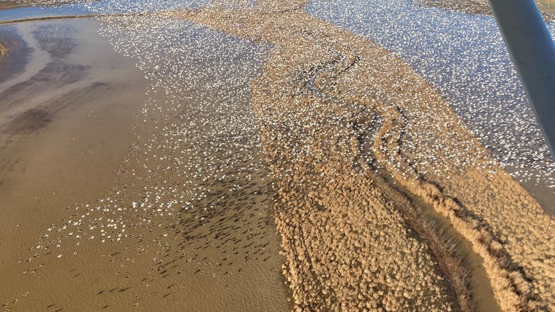
LITTLE ROCK – The best mallard numbers seen in Arkansas in recent years from last month’s aerial survey estimate continued with the Arkansas Game and Fish Commission’s annual midwinter waterfowl survey released this week. The number of mallards in the Delta region of Arkansas hit a four-year high during aerial observations conducted in December, and that was repeated with last week’s count.
Observers estimated 929,248 mallards and more than 1.74 million total ducks on transect lines in eastern Arkansas. Not only was this the highest mallard population recorded during the midwinter survey since 2018, it was the second-highest since 2010. Total duck population estimates also exceeded 1.5 million for the first time in any survey since December 2011.
The aerial survey took place after the influx of arctic air in late December, snow and ice cover in states above Arkansas, and in conjunction with the massive amounts of rainfall in Arkansas during the survey period last week.
The highest mallard and total duck estimates were in the Lower St. Francis survey zone, a region known for more boom-or-bust duck counts driven by the extent of natural flooding on the landscape. Hotspot maps indicated several duck concentration areas throughout the Delta.
Arctic goose population estimates totaled 1,693,343 light geese (lesser snow geese and Ross’s) and 618,925 greater white-fronted geese in the Delta as well.
“The timing of the surveys fell right in line with flooding from the massive storm front that came through Arkansas, and hunters know that ducks have an innate ability to find newly flooded areas and make use of the new habitat and food,” Luke Naylor, AGFC chief of wildlife management, said. “Information from locations north of Arkansas suggested ducks had headed south prior to this event and no doubt found abundant new habitat to settle into across the state.”
Other portions of the state saw variable numbers of ducks, with the Arkansas River Valley recording populations near the long-term average for the midwinter survey and southwestern Arkansas having lower than normal duck populations. The Delta’s rich habitat seemed to be the focus of the waterfowl. Biologists flying along survey routes in the Arkansas River Valley recorded 41,017 total ducks, including 25,943 mallards. Biologists performing cruise surveys in southwest Arkansas reported an estimated 14,283 ducks with 6,180 mallards.
Naylor says improved duck production across the Prairie Pothole Region in 2022 may have contributed to higher midcontinent mallard fall flights and some of the Delta estimate increases, but post-season analysis of duck wings submitted by hunters will be needed to provide insight on the amount of hatch-year birds in the 2022 fall flight.
According to Naylor, the flights for these surveys are conducted at very low elevations, where dangerous situations can arise due to birds flying into the path of the plane if they become spooked. At least one bird strike was recorded during the flights in early January but luckily no one was injured. Biologists Jason Carbaugh, Jason Jackson, Cameron Tatom and Alex Zachary conducted the low-level surveys with contracted pilots. Naylor said, “They have faced some tough conditions this year with delayed surveys from weather conditions and dodging birds, but have done an excellent job of keeping the data as consistent as possible to make accurate evaluations of duck populations so far this season.”
Continue Vigilance With Avian Flu
Hunters are urged by the AGFC to maintain a vigilant lookout for any birds that might be infected or suffering from Highly Pathogenic Avian Influenza. HPAI has been a concern of wildlife biologists this late fall and winter, especially with much evidence of it seen recently among migrating snow geese and other waterfowl and wintering birds in Arkansas. Hunters, outdoors enthusiasts and wildlife watchers are asked to report instances of dead or sick waterfowl that they encounter in the wild. The risk of humans contracting the disease remains low, but hunters can help further minimize that risk by following a few simple precautions (see below). Anyone who observes concentrations of sick or dead birds should report their sighting by using the AGFC’s Avian Influenza Reporting Form.
More information on avian influenza information is available at AGFC, Ducks Unlimited, and USDA APHIS’s website.
Bag Limits
Remember: Daily bag limits are the same as seen in recent years. Hunters make harvest a bag limit of 6 ducks, which may include no more than 4 mallards (2 hens), 1 scaup, 3 wood ducks, 1 pintail, 2 redheads, 2 canvasbacks, 2 black ducks or 1 mottled duck. Beyond those exceptions, the limit is up to 6 ducks of a species, including teal. The merganser daily bag limit is 5, with only 2 hooded mergansers allowed. The daily bag limit for coots is 15. Non-lead shot must be used for waterfowl hunting in Arkansas. The possession limit for ducks, coots and mergansers is three times the daily bag limit. The daily bag limit for greater white-fronted geese 3, up from last year’s 2 birds per day. The daily limit for snow, blue and Ross’s geese is 20 per day.
Waterfowl season in Arkansas will closes at sunset Jan. 31.
Northeast Arkansas
Big Lake WMA
Map | Water Gauge | Weather Report
When the Ditch 81 extension gauge near Manila (upstream of the Big Lake north-end control structure) reads 17.5 feet, water is beginning to come over the north levee degrade on Big Lake WMA. When the Ditch 81 Extension gauge reads 18.0 feet or higher, the water level on the WMA will rise quickly and hunters should exercise caution while on the area. Be aware of underwater logs in boat runs and hangers in trees.
North Woods GTR
Habitat: Mast production is good.
Water Level: BoDoc gauge is inaccessible due to high water; target level is 235.5 feet msl; 100% flooded.
South Woods GTR
Habitat: Mast production is fair.
Water Level: Gauge reading at 7-Mile is 236.6 feet msl; target level is 234.5 feet; 100% flooded.
Simmons Field
Habitat: Native production is good in the middle and south fields.
Water Level: 100% coverage.
Dave Donaldson Black River WMA
Map | Water Gauge | Weather Report
Waterfowl hunters should be aware of hangers and submerged logs within the boat runs and GTRs. Please exercise caution when accessing the area. Please remember to keep boats off the levees so AGFC personnel can access the area. Boats blocking access will be moved. Unattended trailers are not to be left overnight on parking areas. As of Jan. 9, the Black River level is 9.58 feet and falling.
Upper Island GTR
Habitat: Mast crop is moderate within the GTRs.
Water Level: Gauge is inaccessible due to high water. Target level is 269.5; 100% flooded.
Lower Island GTR
Habitat: Mast crop is moderate within the GTRs.
Water Level: Gauge is inaccessible due to high water. Target level is 268.0; 100% flooded.
Upper Reyno GTR
Habitat: Mast crop is moderate within the GTRs.
Water Level: Current level is 268.45 feet msl. Target level is 266.9; 100% flooded.
Lower Reyno GTR
Habitat: Mast crop is moderate within the GTRs.
Water Level: Current level is 268.05 feet msl. Target level is 266.3; 100% flooded.
Winchester GTR
Habitat: Mast crop is moderate within the GTRs.
Water Level: Current level is 264.15 feet msl. Target level is 263.7; 100% flooded.
Earl Buss Bayou DeView WMA
Map | Water Gauge | Weather Report
Boaters should use caution while using the Thompson Tract boat lane. A fair number of ducks and snow geese are currently moving through the area.
South Oliver GTR
Habitat: Mast production is good.
Water Level: Current gauge reading as of Jan. 10 is 2.2 feet; 100% flooded.
Thompson Tract GTR
Habitat: Mast production is good.
Water Level: Current gauge reading as of Jan. 10 is 2.1 feet; 100% flooded. The Thompson Tract GTR will be allowed to rise and fall naturally without the gates being operated later and partially this season. This action in an effort to help the next generation of forest.
Lake Hogue WRA
Habitat: Primarily deep open water habitat.
Water Level: Normal pool level.
Shirey Bay Rainey Brake WMA
Map | Water Gauge | Weather Report
Waterfowl hunters should be aware of hangers and submerged logs within the boat runs and GTRs. Please exercise caution when accessing the area. In addition, hunters should allow safe passage when parking vehicles along roadsides. Vehicles blocking access will be moved.
Adam Brake GTR
Habitat: Mast production is good.
Water Level: Water level is 240.0 feet msl with a target level of 240.0 feet msl; 100% flooded.
Rainey Brake GTR
Habitat: Mast production is good.
Water Level: 100% flooded.
Eagle Pond GTR
Habitat: Mast production is good.
Water Level: 100% flooded.
Phase III Moist-Soil Unit
Habitat: Fair wetland-type vegetation.
Water Level: 100% flooded.
Charles Crisp Moist-Soil Unit
Habitat: Fair wetland-type vegetation.
Water Level: 100% flooded.
Ward Field Moist-Soil Unit
Habitat: Good wetland-type vegetation.
Water Level: 100% flooded.
River Field Moist-Soil Unit
Habitat: Good wetland-type vegetation.
Water Level: 100% flooded.
St. Francis Sunken Lands WMA
Map | Water Gauge | Weather Report
Hunt Area
Habitat: Good mast production within the hunt area.
Water Level: Water levels on St. Francis Sunken Lands for waterfowl season are dependent on flows from the St. Francis River. The target level for providing huntable timber is 212.0 feet msl at the Oak Donnick gauge. The reading as of Jan. 10 was 216.84 feet msl.
Snowden WRA
Habitat: Mixed grasses.
Water Level: 30% flooded.
Payneway WRA
Habitat: A, B, C and D pools have mixed smartweed and barnyard grasses. Moderate mast is available within pools A, B and C as well.
Water Level: Pool A is at 10% coverage. Pool B is at 40%. Pool C is at 50%. Pool D is at 100%.
East-Central Arkansas
Henry Gray Hurricane Lake WMA
Map | Water Gauge | Weather Report
Hunters should call the Wildlife Hotline at 800-440-1477 for current road closures.
North Unit
Habitat: Good mast crop.
Water Level: The White River at Augusta as of Monday, Jan. 9, was 28.29 feet and falling. The water level at Glaise Creek has crested at 192.62 feet. All structures on the North GTR will remain open during the 2022-23 season.
South Unit
Habitat: Fair mast crop.
Water Level: The White River at Augusta is 28.29 feet and falling, nearly a 10-foot rise from a week ago. The water level at Glaise Creek has crested at 192.62 feet. All structures on the South Unit are open.
Rex Hancock Black Swamp WMA
Map | Water Gauge | Weather Report
Hunters should call the Wildlife Hotline at 800-440-1477 for current road closures.
Gregory GTR
Habitat: Good mast crop.
Water Level: 40% flooded. The Cache River at Patterson was at 10.66 feet and stable on Jan. 9.
Wiville Moist-Soil Unit
Habitat: Good stand of native vegetation.
Water Level: 90% flooded.
Sheffield Nelson Dagmar WMA
Map | Water Gauge | Weather Report
The Conway George units are currently available for hunting by applying for online permits. Youths may apply for Saturday and Sunday hunts in the Conway George tracts, with one adult hunter allowed per one youth, up to four hunters in the blind. Hunters of any age may apply for Wednesday permit hunts in the Conway George tracts. Please visit www.agfc.com for maps, special regulations, permit application and draw dates. Hunters should call the Wildlife Hotline at 800-440-1477 for current road closures. The AGFC will not be putting boards in at Dagmar. Water coverage is dependent on river level.
Mud Slough GTR
Habitat: Good mast crop.
Water Level: 60% coverage.
Apple Lake WRA (no hunting)
Habitat: Good mast crop.
Water Level: 60% coverage.
Conway George Waterfowl Unit A
Habitat: Good stand of native vegetation.
Water Level: 90% coverage
Conway George Waterfowl Unit B
Habitat: Natural slough area with beneficial native wetland plants.
Water Level: 90% coverage
Conway George Waterfowl Unit C
Habitat: Good stand of native vegetation.
Water Level: 90% coverage
Dark Corner Waterfowl Unit 1
Habitat: Good stand of native vegetation.
Water Level: 95% coverage
Dark Corner Waterfowl Unit 2
Habitat: Good stand of native vegetation.
Water Level: 70% coverage
Dark Corner Waterfowl Unit 3
Habitat: Good stand of native vegetation.
Water Level: 70% coverage
Steve N. Wilson Raft Creek Bottoms WMA
Hunting in Raft Creek Bottoms WMA requires participation on the online draw a week before the following weekend’s hunt. There is no online draw on Tuesdays and Thursdays, and permits are available at the boat accesses. Permits ARE required (via online application) on weekends, Tuesdays and Thursdays for the youth and mobility-impaired blinds and for the Magellan Tract. Visit agfc.com to apply for the online draw. There will be no designated holes this season.
The White River gauge at Georgetown on Monday, Jan. 9, was 14.73 feet and falling, 8 feet higher than at this time last week.
Unit A
Habitat: Excellent stand of native vegetation.
Water Level: 100% coverage.
Unit B
Habitat: Excellent stand of millet and native vegetation.
Water Level: 100%
Unit C
Habitat: Good stand of native vegetation.
Water Level: 100%
Unit D
Habitat: Good stand of native vegetation.
Water Level: 100%
Unit E
Habitat: Excellent stand of millet and native vegetation.
Water Level: 100%
Unit F (Youth Area)
Habitat: Good stand of millet and native vegetation.
Water Level: 100%
Unit G
Habitat: Habitat conditions are poor.
Water Level: 80%
Unit H (Mobility-impaired blind)
Habitat: Excellent stand of native vegetation.
Water Level: 100%
Unit I
Habitat: Habitat conditions are poor.
Water Level: 60%
Unit J (Cypert Tract)
Habitat: Excellent stand of native vegetation.
Water Level: 90%
Unit K (Cypert Tract)
Habitat: Excellent stand of native vegetation.
Water Level: 50%
Unit L (Cypert Tract)
Habitat: Fair stand of native vegetation.
Water Level: 50%
Unit M (Magellan Tract)
Habitat: Good stand of native vegetation.
Water Level: 100%
Central Arkansas
Bell Slough WMA
Map | Weather Report
The Bell Slough GTR and Palarm Creek WRA are both at full pool now.
Bell Slough GTR
Habitat: Fair mast crop.
Water Level: 100%.
Palarm Creek WRA
Habitat: Rest area was heavily disked late this year and millet crop did not take before the early frost.
Water Level: 100%
Craig D. Campbell Lake Conway Reservoir
Map | Weather Report
Habitat and water levels are normal on both Pierce and Dix creeks.
Cypress Bayou WMA
Hunt Area
Habitat:
Good mast crop.
Water Level: 100% coverage.
Red Cut Slough Tract
Unit 1
Habitat:
Habitat conditions are poor.
Water Level: 60%
Unit 2
Habitat:
Excellent stand of millet and native vegetation
Water Level: 70%
Unit 3
Habitat:
Good stand of millet and native vegetation
Water Level: 100%
Unit 4
Habitat: Good stand of millet and native vegetation.
Water Level: 100%
Unit 5
Habitat:
Good stand of native vegetation.
Water Level: 100%
Unit 6
Habitat:
Good stand of native vegetation.
Water Level: 100%
Harris Brake WMA
Upper GTR
Habitat: Good mast crop.
Water Level: 100% coverage.
Lower GTR
Habitat: Good mast crop.
Water Level: 20% coverage. The Harris Brake Lake valve was opened Nov. 15 to begin supplemental flooding of both the Lower and Upper GTRs. Unfortunately, damage to one of the Lower GTR’s water control structures is allowing water to drain from the Lower GTR and can’t currently be fixed. The Lower GTR will mostly likely drain completely unless the Fourche La Fave overtops the levee and floods the GTR.
Holland Bottoms WMA
Hunt Area
Habitat: Good mast crop.
Water Level: Most of the low-lying areas and sloughs on the WMA are flooded.
Lake Pickthorne WRA (no hunting)
Habitat: Excellent crop of native vegetation and millet.
Water Level: Both the East and West units are 100% flooded and holding waterfowl.
Northwest Arkansas
Dardanelle WMA
McKennon Bottoms (half-day hunting)
Habitat: Good stand of native moist-soil vegetation.
Water Level: 100% coverage
Potter’s Pothole Hartman Waterfowl Unit (half-day hunting)
Habitat: West cell has a poor stand of moist-soil vegetation. East cell has an average stand of moist-soil vegetation.
Water Level: 100% coverage
Ed Gordon Point Remove WMA
With continuted pumping and recent rainfall events, water levels in most waterfowl impoundments on the WMA are now at or near capacity. Duck use on the WMA has been low to moderate.
Little Hole (Unit 1)
Habitat: Japanese millet.
Water Level: 80% flooded.
Willow Island (Unit 2)
Habitat: Japanese millet and natural vegetation.
Water Level: 100%
Red Gate (Unit 3)
Habitat: Natural vegetation
Water Level: 95%
Pig Trough (Units 4 and 5)
Habitat: Natural vegetation.
Water Level: 80%
Cedar Ridge (Unit 6)
Habitat: Japanese millet.
Water Level: 85%
Unit 7a
Habitat: Natural vegetation.
Water Level: 100%
Unit 7b
Habitat: Japanese millet and natural vegetation.
Water Level: 100%
Duck Trap (Units 8a, 8b and 8c)
8a
Habitat: Natural vegetation and Japanese millet.
Water Level: 90%
8b
Habitat: Japanese millett and natural vegetation.
Water Level: 100%
8c
Habitat: Natural vegetation.
Water Level: 80%
Unit 9
Habitat: Natural vegetation.
Water Level: 100%
Controversy Corner (Unit 10)
Habitat: Natural vegetation.
Water Level: 100%
Remmel Marsh
Habitat: Natural vegetation.
Water Level: 100%
Mud Pond (Unit 12)
Habitat: Natural vegetation and Japanese millet.
Water Level: 100%
Turkey Pond (Units 13a, 13b and 13c)
13a
Habitat: Natural vegetation and Japanese millet.
Water Level: 100%
13b
Habitat: Natural vegetation.
Water Level: 90%
13c
Habitat: Natural vegetation and Japanese millet.
Water Level: 100%
Teeny Pond (Unit 14)
Habitat: Natural vegetation.
Water Level: 75%
Salt Lick (Unit 15)
Habitat: Natural vegetation.
Water Level: 75%
Bobby’s Pond (Unit 16)
Habitat: Natural vegetation.
Water Level: 90%
Race Track (Unit 17)
Habitat: Natural vegetation.
Water Level: 100%
Frog Bayou WMA
Due to the dry summer, several units have been fallow-disked in preparation for next season.
Unit 1
Habitat: Good stand of moist-soil vegetation in the upper end, while lower end has been fallow-disked.
Water Level: 100% coverage
Unit 2
Habitat: Has been fallow-disked. Unit is rainfall dependent.
Water Level: 100% flooded.
Unit 3
Habitat: Average stand of moist-soil vegetation on the upper end; lower end has been fallow-disked.
Water Level: 100%
Unit 4
Habitat: Good stand of moist-soil vegetation and planted millet
Water Level: 100%
Unit 5
Habitat: Good stand of moist-soil vegetation on the upper end; lower end has been planted with Japanese millet.
Water Level: 100%
Unit 6
Habitat: Good stand of moist-soil vegetation. Lower end has been fallow-disked.
Water Level: 100%
Unit 7
Habitat: Good stand of moist-soil vegetation.
Water Level: 100%
Galla Creek WMA
Galla Creek
Habitat: Good stands of native vegetation and Japanese millet. The water impoundment is now at full pool.
Water Level: 100% coverage
Nimrod Lloyd Millwood WMA
Nimrod GTR
Habitat: The red oak mast crop is moderate this year as well as the desirable native vegetation growth. Due to abnormally dry conditions, this area is not expected to fill up as fast as in previous years. The water control structures were closed Nov. 15.
Water Level: 100% flooded.
Ozark Lake WMA/Dyer Lake Water Unit
Dyer Lake Cells
Unit 1 Dyer main cell
Habitat: Good stand of moist-soil vegetation.
Water Level: 100% coverage for both units
Unit 2 Dyer Road Cell
Habitat: Poor stand of moist-soil vegetation due to dry conditions over the summer.
Water Level: 100% coverage
Unit 3 South Cell
Habitat: Good stand of moist-soil vegetation and volunteer millet.
Water Level: 25% coverage
Unit 4 West Cell (rainfall dependent)
|Habitat: Good stand of moist-soil vegetation and volunteer millet.
Water Level: 5% coverage
Petit Jean River WMA
Map | Water Gauge | Weather Report
Sorehead Moist-Soil Unit
Habitat: This unit was able to grow a great stand of desirable native vegetation this year. The Kingfisher Lake water control structure valve was opened Nov. 15 to help flood this area.
Water Level: 100%
Blacklands Moist-Soil Unit
Habitat: The red oak mast crop is moderate this year as well as the desirable native vegetation growth. Millet planting was attempted this year, but the dry conditions prevented growth. The recent rains have put enough water in the river to start pumping last week.
Water Level: 100%.
Slaty Crossing Moist-Soil Unit
Habitat: Due to ongoing waterfowl habitat enhancement projects, this unit was not able to grow a desirable native vegetation crop or millet crop this year. The recent rains have put enough water in the river to start pumping last week.
Water Level: 100%
Blacklands Duck Area
Habitat: The red oak mast crop is moderate this year as well as the desirable native vegetation growth. Millet planting was attempted this year, but the dry conditions prevented growth. The Kingfisher Lake water control structure valve was to be opened Nov. 15 to help flood the area.
Water Level: 100%
Pullen Pond Marsh
Habitat: Due to ongoing waterfowl habitat enhancement projects, parts of the central section and western section of this area is bare ground. Most of the area has a great stand of desirable native vegetation. The water control structures were closed on Nov. 4.
Water Level: 60%. Flooding of the area is rainfall dependent.
Pond Creek GTR
Habitat: The red oak mast crop is moderate this year as well as the desirable native vegetation growth. Due to abnormally dry conditions, this area is not expected to fill up as fast as in previous years. The water control structures were closed Nov. 15.
Water Level: 20%. Flooding of this area is rainfall dependent.
Slaty GTR
Habitat: The red oak mast crop is moderate this year. Due to abnormally dry conditions, this area is not expected to fill up fast as in previous years. The water control structures were closed Nov. 16.
Water Level: 5%. Flooding of this area is rainfall dependent.
Santa Fe GTR
Habitat: The red oak mast crop is moderate this year as well as the desirable native vegetation growth. Due to abnormally dry conditions, this area is not expected to fill up as fast as in previous years. The water control structures were closed Nov. 15.
Water Level: 100%. Flooding of this area is rainfall dependent.
Southwest Arkansas
Dr. Lester Sitzes III Bois d’Arc WMA
Bois d’Arc Lake WRA
Habitat: Closed to hunting.
Water Level: Normal
Red Slough WRA
Habitat: Closed to hunting.
Water Level: 90% coverage.
GTR
Habitat: Good mast production.
Water Level: 100% coverage.
Little Grassy
Habitat: Good
Water Level: 100% coverage.
Millwood Lake
Map | Water Gauge | Weather Report
Habitat: Habitat conditions are good.
Water Level: Millwood was at 259.66 feet msl as of Jan. 11.
Ozan WMA
Flooding of all units is rainfall dependent.
Unit 1
Habitat: Good
Water Level: 0%
Unit 2
Habitat: Good
Water Level: 0%
Unit 3
Habitat: Good
Water Level: 0%
Unit 4
Habitat: Good
Water Level: 0%
Unit 5
Habitat: Good
Water Level: 0%
Sulphur River WMA
Mercer Bayou
Habitat: Fair
Water Level: 90%
Henry Moore WRA
Habitat: Closed to hunting.
Water Level: 60%
Southeast Arkansas
Beryl Anthony Lower Ouachita WMA
Map | Weather Report
Water Level: Water is available in the oxbow lakes located in the WMA. The Ouachita River below Felsenthal Lock and Dam is now flooding some lower areas of the WMA. Due to flooding, the Clear Lake Road is closed at this time.
Cut-Off Creek WMA
Map | Weather Report
Hunt Area
Habitat: Habitat conditions are good.
Water Level: Water levels are rising due to heavy rains and some roads may be impassable due to flooding.
Pigeon Creek WRA
Habitat: Habitat conditions are good.
Water Level: Fully flooded.
Freddie Black Choctaw Island WMA Deer Research Area
Map | Water Gauge | Weather Report
Habitat conditions are good. Flooding is river dependent. Click on the Water Gauge link above for current Mississippi River levels. Use extreme caution when boating in the river.
The Freddie Black Choctaw Island WMA West Unit allows weekend permit hunting for youths (one adult per youth hunter); on Wednesdays, all ages may apply for a permit to hunt the blinds in the West Unit.
George H. Dunklin Jr. Bayou Meto WMA
Map | Water Gauge | Weather Report
The UGSG is reporting real-time water gauge readings at the headwater at each GTR within the George H. Dunklin Bayou Meto WMA. Click the Water Gauge link above for the WMA, and search for the particular GTR as noted.
NOTE: During the 2022-23 wintering period, all intentional flooding will be held at 178.5 feet msl, an elevation that will relieve stress on many trees such as red oaks that are showing signs of distress. Rain and increased flow into the WMA will allow water to rise above that level periodically. A good rule of thumb for comparing water levels to access into Bayou Meto: 176 feet msl – water breaking into sloughs and lower ditches; 177-177.5 feet msl – water beginning to break out of sloughs and lower ditches; 178 feet msl – water in most sloughs and ditches and entering into lower elevations in woods; 178.5 feet msl – most ditches and sloughs deep enough to boat and most boat ramps become serviceable; 179 feet msl or above – water expands to the higher elevations.
Upper Vallier GTR
Habitat: Good
Water Level: See Gauge Link (Upper Vallier Headwater) for updated info.
Lower Vallier GTR
Habitat: Good
Water Level: See Gauge Link (Lower Vallier Headwater) for updated info. Use extreme caution around water control structures due to high volume of water.
Government Cypress GTR
Habitat: Good
Water Level: See Gauge Link (Government Cypress Headwater) for updated info.
Buckingham Flats GTR
Habitat: Good
Water Level: See Gauge Link (Buckingham Flats Headwater) for updated info.
Temple Island GTR
Habitat: Good
Water Level: See Gauge Link (Temple Island Headwater) for updated info.
Canon Brake
Habitat: Good
Water Level: See Gauge Link (Canon Brake Headwater) for updated info. Use extreme caution around water control structures due to high volume of water.
Halowell WRA
Habitat: Excellent
Water Level: Staggered flooding of units.
Wrape Plantation WRA
Habitat: Excellent
Water Level: Staggered flooding of units.
Seven Devils WMA
Hunt Area
Habitat: Habitat conditions are good.
Water Level: Completed flooded. Due to excessive rainfall, some roads may be impasable.
Trusten Holder WMA
Map | Water Gauge | Weather Report
Habitat conditions are good. Flooding is river dependent. Click on the Water Gauge link above for current Arkansas River levels.
Recent News
Arkansas Wildlife Weekly Fishing Report
Apr. 18, 2024
Subscribe to Our Weekly Newsletter E-mails
Don’t miss another issue. Sign up now to receive the AGFC Wildlife Weekly Newsletter in your mailbox every Wednesday afternoon (Waterfowl Reports are published weekly during waterfowl season and periodically outside the season). Fishing Reports arrive on Thursdays. Fill in the following fields and hit submit. Thanks, and welcome!