Arkansas Wildlife Weekly Waterfowl Report
BY Jim Harris
ON 01-25-2023
Jan. 25, 2023
Jim Harris
Managing Editor Arkansas Wildlife Magazine
Mallard Numbers Tumble in Final Aerial Survey With Weather Changes
In the final statewide aerial survey of the 2022-23 waterfowl wintering period, Arkansas Game and Fish Commission staff last week saw a drop in mallards and total ducks across the Mississippi Alluvial Valley (the Delta) compared with the staff’s midwinter survey from two weeks ago, though the number of all ducks in the Delta stayed in line with the long-term average.
AGFC biologists Jason Carbaugh, Jason Jackson, Cameron Tatom and Alex Zachary conducted the final survey. Using transect-based surveys in the Delta, the staff estimated 464,742 mallards and 1,207,170 total ducks. The Delta mallard population estimate was about half the midwinter estimate (taken Jan. 2-5) and about 35 percent below the late-January long-term average.
On the other hand, total duck estimates in the Delta were similar to the long-term average, even though estimates declined about 30 percent from the previous survey.
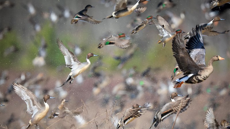
High mallard numbers driven by widespread flooding during the midwinter waterfowl survey period declined as habitat appeared to decline before this final survey. The onset of spring migration – driven in part by south winds and warming temperatures – led to more non-mallard dabbling ducks in the state during this survey. Species such as green-winged teal, northern pintail and northern shoveler (see photo above from the Holland Bottoms WMA rest area) are quick to respond to such conditions, moving north into Arkansas as mallards perhaps move north out of Arkansas.
Most mallards were making use of remaining habitat provided in agricultural fields and moist-soil habitat in both the Delta and Arkansas River Valley, with about 23 percent of River Valley mallards using oxbow lakes and buttonbush wetlands.
On average, mallards account for 57 percent of all ducks in the Delta in late January, but this year 38 percent of all ducks in the Delta were mallards.
Several mallard estimates by survey zone showed major declines from high midwinter counts. Notably, this survey’s mallard estimate was only 27 percent of the count two weeks ago in the Lower St. Francis survey zone. The Bayou Meto-Lower Arkansas and Black-Upper White saw similar declines, tough not quite as severe, with the Cache survey zone mallard estimate dropping only about 25 percent. Hot spot maps from the survey show duck concentrations along the Cache River corridor, with few hot spots east of Crowley’s Ridge or south of the Arkansas River.
Mallards were broadly distributed across the Grand Prairie.
An estimated 28,943 total ducks were seen in the Arkansas River Valley, including 15,530 mallards. Staff performing cruise surveys in southwest Arkansas reported observing 19,174 ducks with 3,746 mallards in surveyed areas.
Arctic goose population estimates in the Delta totaled 626,923 light (lesser snow and Ross’s) geese and 229,317 greater white-fronted geese, a big drop from the midwinter survey in both categories.
The annual midwinter survey conducted two weeks before this survey followed an influx of arctic air into Arkansas. The largest rain event of this wintering period followed shortly after the cold front, leading to substantial and sudden increases in unmanaged habitat availability across the state. Much of that habitat likely had dwindled by the time of this survey last week, with south winds and warming temperatures dominating the weather pattern.
“This changing pattern is reflected in these results,” Luke Naylor, the AGFC’s chief of wildlife management, said.
Arkansas River Valley mallard and total duck estimates were less than those during the midwinter survey and below long-term averages. Once again, the vast majority of mallards and all ducks were estimated in the Point Remove-Plumerville survey zone, with the next-highest estimates in the Petit Jean zone. In fact, 60 percent of mallards and 69 percent of all ducks were observed in the Point Remove-Plumerville zone. The mallard and total duck concentration areas in and around the Blackwell Bottoms again stand out as unique in the river valley.
Southwest Arkansas cruise survey counts showed low numbers of mallards and somewhat lower number of all ducks in surveyed regions.
Waterfowl Use Moist Soil, Rest Areas to Prep for Northward Trip
A small triangle of land totaling about 90 acres, Lake Pickthorne Waterfowl Rest Area inside Holland Bottoms Wildlife Management Area outside Jacksonville, plays a huge role in the Arkansas Game and Fish Commission’s moist-soil wetland habitat program. Jason “Buck” Jackson, the AGFC’s statewide wetlands program coordinator, said. “It’s important to me since we don’t have any other ‘primo’ moist-soil communities close to that (western) side of the (Arkansas) Delta. Cypress Bayou WMA up in Beebe, a little more northeast, would be the closest.” Jackson defines “primo” as a high-producing food unit for the migrating birds.
Jackson says that all the moist-soil units across the east-central portion of the state tie together to provide food and habitat for migrating waterfowl. In recent days the moist-soil units on Holland Bottoms’ rest area has seen thousands of ducks. While no hunting of any kind is allowed on the rest area between Nov. 1-Feb. 15, the rest of the WMA is huntable, and the chance of ducks coming off the rest area to search for other nearby landing spots presents good potential for waterfowl hunters.
“There is hunting opportunity, but you probably have to use a map to get around,” Clifton Jackson, the AGFC’s biologist for Holland Bottoms WMA, said. “The elevation doesn’t vary a lot. It doesn’t take a lot of rainfall to flood the sloughs and creeks that run through. That provides pretty good duck hunting. You just have to find a spot where there might be some ducks.”
Eric Wickman, the AGFC’s technician on Holland Bottoms, handles the heavy labor of preparing the Pickthorne WRA with direction from Buck Jackson and AGFC statewide wetlands senior technician Jeffrey Cothern. The work to prepare the two units of the rest area this season began within days of the close of last season.
“It started with taking soil samples,” Wickman said of work he’ll repeat again next month after this year’s season closes Jan. 31. The samples help determine what type and amount of soil amendments, such as lime or fertilizer, will be needed. The wetlands staff then puts a cleated roller to the soil while there is still some water on it. This chews up remaining debris from last year’s plants, scatters seeds not consumed by waterfowl the previous winter and incorporates the decaying plant matter into the soil to make it available for this year’s yield producing plants.
“We’re looking for the highest yield of product we can get, whether it be through native vegetation or planting of various millet species, to produce the most duck energy days possible for migrating waterfowl,” Wickman said.
Read more about the work at Holland Bottom and the AGFC’s other moist-soil units here.
Season Coming to an End Tuesday, Jan. 31
Next Tuesday will mark the last day of waterfowl hunting in Arkansas. In keeping with tradition, hunters on most public land in Arkansas will be able to hunt until sunset. Normally, hunting on the Wildlife Management Areas would wrap up at noon. The exception is any WMA that is closed to hunting on Tuesdays. Some WMAs are only open to permit hunting on Wednesdays and therefore won’t be open Jan. 31. Steve N. Wilson Raft Creek Bottoms WMA requires a permit to hunt that can be picked up at the visitor kiosk and returned after the hunt. The youth and mobility-impaired blinds and the Magellan Tract require an online permit, which may be applied for Jan. 26-29.
The rest of the state, on public or private land, will conclude hunting at sunset. The Light Goose Conservation Order, which offers liberal hunting rules for snows, blues and Ross’s geese, begins on Wednesday, Feb. 1, continues through Friday, is closed for the Special Hunt Day for Youth, Veterans and Active Military on Feb. 4, then resumes unabated through April 25. REMEMBER: While greater white-front geese are still being seen in prolific numbers around the Delta, they ARE NOT light geese and therefore not hunted during the Light Goose Conservation Order.
Youth Can Apply for WRICE Permits
One great opportunity for youth hunters under 16 taking advantage of the Arkansas Game and Fish Commission’s second special hunt day on Saturday, Feb. 4, is a WRICE program hunt. Youths may apply beginning Thursday and through midnight Sunday, Jan. 29, for any of the available WRICE fields that are available around the state. Youths may take a mentor with them to call and help retrieve ducks, but anyone over 15 cannot hunt unless they also happen to be a veteran or active military.
The AGFC licensing system is not set up to accept any applications for WRICE fields for the veterans or active military, but they can accompany a youth whose application is selected.
Youths may also apply for any youth blinds available at WMAs for the Feb. 4, but they can also hunt the entire huntable space of those areas. This includes Steve N. Wilson Raft Creek Bottoms, Red Cut Slough of Cypress Bayou, Sheffield Nelson Dagmar and Freddie Black Choctaw Island West Unit WMAs, which would usually be permit only hunting on weekends.
To apply for permits, click on the “Buy Licenses/Check Game” tab on the agfc.com website, or visit the information page on the website by clicking here. Youths under 16 do not have to have a hunting license to hunt, but they need to have a customer identification number to access the licensing and application site. Hunters 16 and over will not be recognized by the site for applications on Feb. 4, hence that is why veterans and active military will also not be able to apply for special permits such as WRICE.
Northeast Arkansas
Big Lake WMA
Map | Water Gauge | Weather Report
When the Ditch 81 extension gauge near Manila (upstream of the Big Lake north-end control structure) reads 17.5 feet, water is beginning to come over the north levee degrade on Big Lake WMA. When the Ditch 81 Extension gauge reads 18.0 feet or higher, the water level on the WMA will rise quickly and hunters should exercise caution while on the area. Be aware of underwater logs in boat runs and hangers in trees.
North Woods GTR
Habitat: Mast production is good.
Water Level: The BoDoc gauge is at 237.6 feet msl; target level is 235.5 feet msl; 100% flooded.
South Woods GTR
Habitat: Mast production is fair.
Water Level: Gauge reading at 7-Mile is 236.5 feet msl; target level is 234.5 feet; 100% flooded.
Simmons Field
Habitat: Native production is good in the middle and south fields.
Water Level: 100% coverage.
Dave Donaldson Black River WMA
Map | Water Gauge | Weather Report
Waterfowl hunters should be aware of hangers and submerged logs within the boat runs and GTRs. Please exercise caution when accessing the area. Please remember to keep boats off the levees so AGFC personnel can access the area. Boats blocking access will be moved. Unattended trailers are not to be left overnight on parking areas. As of Jan. 23, the Black River level is 9.47 feet and falling.
Upper Island GTR
Habitat: Mast crop is moderate within the GTRs.
Water Level: Gauge is inaccessible due to high water. Target level is 269.5; 100% flooded.
Lower Island GTR
Habitat: Mast crop is moderate within the GTRs.
Water Level: Gauge is inaccessible due to high water. Target level is 268.0; 100% flooded.
Upper Reyno GTR
Habitat: Mast crop is moderate within the GTRs.
Water Level: Current level is 267.85 feet msl. Target level is 266.9; 100% flooded.
Lower Reyno GTR
Habitat: Mast crop is moderate within the GTRs.
Water Level: Current level is 267.35 feet msl. Target level is 266.3; 100% flooded.
Winchester GTR
Habitat: Mast crop is moderate within the GTRs.
Water Level: Current level is 264.4 feet msl. Target level is 263.7; 100% flooded.
Earl Buss Bayou DeView WMA
Map | Water Gauge | Weather Report
Boaters should use caution while using the Thompson Tract boat lane. A fair number of ducks and snow geese are currently moving through the area.
South Oliver GTR
Habitat: Mast production is good.
Water Level: Current gauge reading as of Jan. 24 is 1.4 feet; 100% flooded.
Thompson Tract GTR
Habitat: Mast production is good.
Water Level: Current gauge reading as of Jan. 24 is 1.3 feet; 100% flooded. The Thompson Tract GTR will be allowed to rise and fall naturally without the gates being operated later and partially this season. This action in an effort to help the next generation of forest.
Lake Hogue WRA
Habitat: Primarily deep open water habitat.
Water Level: Normal pool level.
Shirey Bay Rainey Brake WMA
Map | Water Gauge | Weather Report
Waterfowl hunters should be aware of hangers and submerged logs within the boat runs and GTRs. Please exercise caution when accessing the area. In addition, hunters should allow safe passage when parking vehicles along roadsides. Vehicles blocking access will be moved.
Adam Brake GTR
Habitat: Mast production is good.
Water Level: Water level is 239.8 feet msl with a target level of 240.0 feet msl; 100% flooded.
Rainey Brake GTR
Habitat: Mast production is good.
Water Level: 100% flooded.
Eagle Pond GTR
Habitat: Mast production is good.
Water Level: 100% flooded.
Phase III Moist-Soil Unit
Habitat: Fair wetland-type vegetation.
Water Level: 100% flooded.
Charles Crisp Moist-Soil Unit
Habitat: Fair wetland-type vegetation.
Water Level: 100% flooded.
Ward Field Moist-Soil Unit
Habitat: Good wetland-type vegetation.
Water Level: 100% flooded.
River Field Moist-Soil Unit
Habitat: Good wetland-type vegetation.
Water Level: 100% flooded.
St. Francis Sunken Lands WMA
Map | Water Gauge | Weather Report
Hunt Area
Habitat: Good mast production within the hunt area.
Water Level: Water levels on St. Francis Sunken Lands for waterfowl season are dependent on flows from the St. Francis River. The target level for providing huntable timber is 212.0 feet msl at the Oak Donnick gauge. The reading as of Jan. 24 was 214.53 feet msl.
Snowden WRA
Habitat: Mixed grasses.
Water Level: 30% flooded.
Payneway WRA
Habitat: A, B, C and D pools have mixed smartweed and barnyard grasses. Moderate mast is available within pools A, B and C as well.
Water Level: Pool A is at 10% coverage. Pool B is at 40%. Pool C is at 50%. Pool D is at 100%.
East-Central Arkansas
Henry Gray Hurricane Lake WMA
Map | Water Gauge | Weather Report
Hunters should call the Wildlife Hotline at 800-440-1477 for current road closures.
North Unit
Habitat: Good mast crop.
Water Level: The White River at Augusta as of Monday, Jan. 24, was 22.77 feet and falling. The water level at Glaise Creek has crested at 190.15 feet and cresting. All structures on the North GTR will remain open during the 2022-23 season.
South Unit
Habitat: Fair mast crop.0.152.62 feet. All structures on the South Unit are open.
Rex Hancock Black Swamp WMA
Map | Water Gauge | Weather Report
Hunters should call the Wildlife Hotline at 800-440-1477 for current road closures.
Gregory GTR
Habitat: Good mast crop.
Water Level: 40% flooded. The Cache River at Patterson was at 9.94 feet and stable on Jan. 24.
Wiville Moist-Soil Unit
Habitat: Good stand of native vegetation.
Water Level: 90% flooded.
Sheffield Nelson Dagmar WMA
Map | Water Gauge | Weather Report
The Conway George units are currently available for hunting by applying for online permits. Youths may apply for Saturday and Sunday hunts in the Conway George tracts, with one adult hunter allowed per one youth, up to four hunters in the blind. Hunters of any age may apply for Wednesday permit hunts in the Conway George tracts. Please visit www.agfc.com for maps, special regulations, permit application and draw dates. Hunters should call the Wildlife Hotline at 800-440-1477 for current road closures. The AGFC will not be putting boards in at Dagmar. Water coverage is dependent on river level.
Mud Slough GTR
Habitat: Good mast crop.
Water Level: 50% coverage.
Apple Lake WRA (no hunting)
Habitat: Good mast crop.
Water Level: 60% coverage.
Conway George Waterfowl Unit A
Habitat: Good stand of native vegetation.
Water Level: 90% coverage
Conway George Waterfowl Unit B
Habitat: Natural slough area with beneficial native wetland plants.
Water Level: 90% coverage
Conway George Waterfowl Unit C
Habitat: Good stand of native vegetation.
Water Level: 90% coverage
Dark Corner Waterfowl Unit 1
Habitat: Good stand of native vegetation.
Water Level: 95% coverage
Dark Corner Waterfowl Unit 2
Habitat: Good stand of native vegetation.
Water Level: 75% coverage
Dark Corner Waterfowl Unit 3
Habitat: Good stand of native vegetation.
Water Level: 75% coverage
Steve N. Wilson Raft Creek Bottoms WMA
Hunting in Raft Creek Bottoms WMA requires participation on the online draw a week before the following weekend’s hunt. There is no online draw on Tuesdays and Thursdays, and permits are available at the boat accesses. Permits ARE required (via online application) on weekends, Tuesdays and Thursdays for the youth and mobility-impaired blinds and for the Magellan Tract. Visit agfc.com to apply for the online draw. There will be no designated holes this season.
The White River gauge at Georgetown on Tuesday, Jan. 24, was 11.05 feet and rising.
Unit A
Habitat: Excellent stand of native vegetation.
Water Level: 100% coverage.
Unit B
Habitat: Excellent stand of millet and native vegetation.
Water Level: 100%
Unit C
Habitat: Good stand of native vegetation.
Water Level: 100%
Unit D
Habitat: Good stand of native vegetation.
Water Level: 100%
Unit E
Habitat: Excellent stand of millet and native vegetation.
Water Level: 100%
Unit F (Youth Area)
Habitat: Good stand of millet and native vegetation.
Water Level: 100%
Unit G
Habitat: Habitat conditions are poor.
Water Level: 100%
Unit H (Mobility-impaired blind)
Habitat: Excellent stand of native vegetation.
Water Level: 100%
Unit I
Habitat: Habitat conditions are poor.
Water Level: 100%
Unit J (Cypert Tract)
Habitat: Excellent stand of native vegetation.
Water Level: 100%
Unit K (Cypert Tract)
Habitat: Excellent stand of native vegetation.
Water Level: 50%
Unit L (Cypert Tract)
Habitat: Fair stand of native vegetation.
Water Level: 50%
Unit M (Magellan Tract)
Habitat: Good stand of native vegetation.
Water Level: 100%
Central Arkansas
Bell Slough WMA
Map | Weather Report
The Bell Slough GTR and Palarm Creek WRA are both at full pool now.
Bell Slough GTR
Habitat: Fair mast crop.
Water Level: 100%.
Palarm Creek WRA
Habitat: Rest area was heavily disked late this year and millet crop did not take before the early frost.
Water Level: 100%
Craig D. Campbell Lake Conway Reservoir
Map | Weather Report
Habitat and water levels are normal on both Pierce and Dix creeks.
Cypress Bayou WMA
Hunt Area
Habitat:
Good mast crop.
Water Level: 100% coverage.
Red Cut Slough Tract
Unit 1
Habitat:
Habitat conditions are poor.
Water Level: 70%
Unit 2
Habitat:
Excellent stand of millet and native vegetation
Water Level: 80%
Unit 3
Habitat:
Good stand of millet and native vegetation
Water Level: 100%
Unit 4
Habitat: Good stand of millet and native vegetation.
Water Level: 100%
Unit 5
Habitat:
Good stand of native vegetation.
Water Level: 100%
Unit 6
Habitat:
Good stand of native vegetation.
Water Level: 100%
Harris Brake WMA
Upper GTR
Habitat: Good mast crop.
Water Level: 100% coverage.
Lower GTR
Habitat: Good mast crop.
Water Level: 20% coverage. The Harris Brake Lake valve was opened Nov. 15 to begin supplemental flooding of both the Lower and Upper GTRs. Unfortunately, damage to one of the Lower GTR’s water control structures is allowing water to drain from the Lower GTR and can’t currently be fixed. The Lower GTR will mostly likely drain completely unless the Fourche La Fave overtops the levee and floods the GTR.
Holland Bottoms WMA
Hunt Area
Habitat: Good mast crop.
Water Level: Most of the low-lying areas and sloughs on the WMA are flooded.
Lake Pickthorne WRA (no hunting)
Habitat: Excellent crop of native vegetation and millet.
Water Level: Both the East and West units are 100% flooded and holding waterfowl.
Northwest Arkansas
Dardanelle WMA
McKennon Bottoms (half-day hunting)
Habitat: Good stand of native moist-soil vegetation.
Water Level: 100% coverage
Potter’s Pothole Hartman Waterfowl Unit (half-day hunting)
Habitat: West cell has a poor stand of moist-soil vegetation. East cell has an average stand of moist-soil vegetation.
Water Level: 100% coverage
Ed Gordon Point Remove WMA
All waterfowl impoundments on the WMA are now at or near capacity. Duck use on the WMA has been moderate.
Little Hole (Unit 1)
Habitat: Japanese millet.
Water Level: 80% flooded.
Willow Island (Unit 2)
Habitat: Japanese millet and natural vegetation.
Water Level: 100%
Red Gate (Unit 3)
Habitat: Natural vegetation
Water Level: 95%
Pig Trough (Units 4 and 5)
Habitat: Natural vegetation.
Water Level: 80%
Cedar Ridge (Unit 6)
Habitat: Japanese millet.
Water Level: 90%
Unit 7a
Habitat: Natural vegetation.
Water Level: 100%
Unit 7b
Habitat: Japanese millet and natural vegetation.
Water Level: 100%
Duck Trap (Units 8a, 8b and 8c)
8a
Habitat: Natural vegetation and Japanese millet.
Water Level: 90%
8b
Habitat: Japanese millett and natural vegetation.
Water Level: 100%
8c
Habitat: Natural vegetation.
Water Level: 90%
Unit 9
Habitat: Natural vegetation.
Water Level: 100%
Controversy Corner (Unit 10)
Habitat: Natural vegetation.
Water Level: 100%
Remmel Marsh
Habitat: Natural vegetation.
Water Level: 100%
Mud Pond (Unit 12)
Habitat: Natural vegetation and Japanese millet.
Water Level: 100%
Turkey Pond (Units 13a, 13b and 13c)
13a
Habitat: Natural vegetation and Japanese millet.
Water Level: 100%
13b
Habitat: Natural vegetation.
Water Level: 90%
13c
Habitat: Natural vegetation and Japanese millet.
Water Level: 100%
Teeny Pond (Unit 14)
Habitat: Natural vegetation.
Water Level: 75%
Salt Lick (Unit 15)
Habitat: Natural vegetation.
Water Level: 90%
Bobby’s Pond (Unit 16)
Habitat: Natural vegetation.
Water Level: 90%
Race Track (Unit 17)
Habitat: Natural vegetation.
Water Level: 100%
Frog Bayou WMA
Due to the dry summer, several units have been fallow-disked in preparation for next season.
Unit 1
Habitat: Good stand of moist-soil vegetation in the upper end, while lower end has been fallow-disked.
Water Level: 100% coverage
Unit 2
Habitat: Has been fallow-disked. Unit is rainfall dependent.
Water Level: 100% flooded.
Unit 3
Habitat: Average stand of moist-soil vegetation on the upper end; lower end has been fallow-disked.
Water Level: 100%
Unit 4
Habitat: Good stand of moist-soil vegetation and planted millet
Water Level: 100%
Unit 5
Habitat: Good stand of moist-soil vegetation on the upper end; lower end has been planted with Japanese millet.
Water Level: 100%
Unit 6
Habitat: Good stand of moist-soil vegetation. Lower end has been fallow-disked.
Water Level: 100%
Unit 7
Habitat: Good stand of moist-soil vegetation.
Water Level: 100%
Galla Creek WMA
Galla Creek
Habitat: Good stands of native vegetation and Japanese millet. The water impoundment is now at full pool.
Water Level: 100% coverage
Nimrod Lloyd Millwood WMA
Nimrod GTR
Habitat: The red oak mast crop is moderate this year as well as the desirable native vegetation growth. Due to abnormally dry conditions, this area is not expected to fill up as fast as in previous years. The water control structures were closed Nov. 15.
Water Level: 100% flooded.
Ozark Lake WMA/Dyer Lake Water Unit
Dyer Lake Cells
Unit 1 Dyer main cell
Habitat: Good stand of moist-soil vegetation.
Water Level: 100% coverage for both units
Unit 2 Dyer Road Cell
Habitat: Poor stand of moist-soil vegetation due to dry conditions over the summer.
Water Level: 100% coverage
Unit 3 South Cell
Habitat: Good stand of moist-soil vegetation and volunteer millet.
Water Level: 25% coverage
Unit 4 West Cell (rainfall dependent)
|Habitat: Good stand of moist-soil vegetation and volunteer millet.
Water Level: 5% coverage
Petit Jean River WMA
Map | Water Gauge | Weather Report
Sorehead Moist-Soil Unit
Habitat: This unit was able to grow a great stand of desirable native vegetation this year. The Kingfisher Lake water control structure valve was opened Nov. 15 to help flood this area.
Water Level: 100%
Blacklands Moist-Soil Unit
Habitat: The red oak mast crop is moderate this year as well as the desirable native vegetation growth. Millet planting was attempted this year, but the dry conditions prevented growth. The recent rains have put enough water in the river to start pumping last week.
Water Level: 100%.
Slaty Crossing Moist-Soil Unit
Habitat: Due to ongoing waterfowl habitat enhancement projects, this unit was not able to grow a desirable native vegetation crop or millet crop this year. The recent rains have put enough water in the river to start pumping last week.
Water Level: 100%
Blacklands Duck Area
Habitat: The red oak mast crop is moderate this year as well as the desirable native vegetation growth. Millet planting was attempted this year, but the dry conditions prevented growth. The Kingfisher Lake water control structure valve was to be opened Nov. 15 to help flood the area.
Water Level: 100%
Pullen Pond Marsh
Habitat: Due to ongoing waterfowl habitat enhancement projects, parts of the central section and western section of this area is bare ground. Most of the area has a great stand of desirable native vegetation. The water control structures were closed on Nov. 4.
Water Level: 60%. Flooding of the area is rainfall dependent.
Pond Creek GTR
Habitat: The red oak mast crop is moderate this year as well as the desirable native vegetation growth. Due to abnormally dry conditions, this area is not expected to fill up as fast as in previous years. The water control structures were closed Nov. 15.
Water Level: 50%. Flooding of this area is rainfall dependent.
Slaty GTR
Habitat: The red oak mast crop is moderate this year. Due to abnormally dry conditions, this area is not expected to fill up fast as in previous years. The water control structures were closed Nov. 16.
Water Level: 5%. Flooding of this area is rainfall dependent.
Santa Fe GTR
Habitat: The red oak mast crop is moderate this year as well as the desirable native vegetation growth. Due to abnormally dry conditions, this area is not expected to fill up as fast as in previous years. The water control structures were closed Nov. 15.
Water Level: 100%. Flooding of this area is rainfall dependent.
Southwest Arkansas
Dr. Lester Sitzes III Bois d’Arc WMA
Bois d’Arc Lake WRA
Habitat: Closed to hunting.
Water Level: Normal
Red Slough WRA
Habitat: Closed to hunting.
Water Level: 90% coverage.
GTR
Habitat: Good mast production.
Water Level: 100% coverage.
Little Grassy
Habitat: Good
Water Level: 100% coverage.
Millwood Lake
Map | Water Gauge | Weather Report
Habitat: Habitat conditions are good.
Water Level: Millwood was at 259.60 feet msl as of Jan. 24
Ozan WMA
Flooding of all units is rainfall dependent.
Unit 1
Habitat: Good
Water Level: 0%
Unit 2
Habitat: Good
Water Level: 0%
Unit 3
Habitat: Good
Water Level: 0%
Unit 4
Habitat: Good
Water Level: 0%
Unit 5
Habitat: Good
Water Level: 0%
Sulphur River WMA
Mercer Bayou
Habitat: Fair
Water Level: 90%
Henry Moore WRA
Habitat: Closed to hunting.
Water Level: 60%
Southeast Arkansas
Beryl Anthony Lower Ouachita WMA
Map | Weather Report
Water Level: Water is available in the oxbow lakes located in the WMA. The Ouachita River below Felsenthal Lock and Dam is now flooding some lower areas of the WMA. Due to flooding, the Clear Lake Road is closed at this time.
Cut-Off Creek WMA
Map | Weather Report
Hunt Area
Habitat: Habitat conditions are good.
Water Level: Water levels remain high; all but the Lower East parking area can now be accessed.
Pigeon Creek WRA
Habitat: Habitat conditions are good.
Water Level: Fully flooded.
Freddie Black Choctaw Island WMA Deer Research Area
Map | Water Gauge | Weather Report
Habitat conditions are good. Flooding is river dependent. Click on the Water Gauge link above for current Mississippi River levels. Use extreme caution when boating in the river.
The Freddie Black Choctaw Island WMA West Unit allows weekend permit hunting for youths (one adult per youth hunter); on Wednesdays, all ages may apply for a permit to hunt the blinds in the West Unit.
George H. Dunklin Jr. Bayou Meto WMA
Map | Water Gauge | Weather Report
The UGSG is reporting real-time water gauge readings at the headwater at each GTR within the George H. Dunklin Bayou Meto WMA. Click the Water Gauge link above for the WMA, and search for the particular GTR as noted.
NOTE: During the 2022-23 wintering period, all intentional flooding will be held at 178.5 feet msl, an elevation that will relieve stress on many trees such as red oaks that are showing signs of distress. Rain and increased flow into the WMA will allow water to rise above that level periodically. A good rule of thumb for comparing water levels to access into Bayou Meto: 176 feet msl – water breaking into sloughs and lower ditches; 177-177.5 feet msl – water beginning to break out of sloughs and lower ditches; 178 feet msl – water in most sloughs and ditches and entering into lower elevations in woods; 178.5 feet msl – most ditches and sloughs deep enough to boat and most boat ramps become serviceable; 179 feet msl or above – water expands to the higher elevations.
Upper Vallier GTR
Habitat: Good
Water Level: See Gauge Link (Upper Vallier Headwater) for updated info.
Lower Vallier GTR
Habitat: Good
Water Level: See Gauge Link (Lower Vallier Headwater) for updated info. Use extreme caution around water control structures due to high volume of water.
Government Cypress GTR
Habitat: Good
Water Level: See Gauge Link (Government Cypress Headwater) for updated info.
Buckingham Flats GTR
Habitat: Good
Water Level: See Gauge Link (Buckingham Flats Headwater) for updated info.
Temple Island GTR
Habitat: Good
Water Level: See Gauge Link (Temple Island Headwater) for updated info.
Canon Brake
Habitat: Good
Water Level: See Gauge Link (Canon Brake Headwater) for updated info. Use extreme caution around water control structures due to high volume of water.
Halowell WRA
Habitat: Excellent
Water Level: Staggered flooding of units.
Wrape Plantation WRA
Habitat: Excellent
Water Level: Staggered flooding of units.
Seven Devils WMA
Hunt Area
Habitat: Habitat conditions are good.
Water Level: Completed flooded. Roads accessible at this time.
Trusten Holder WMA
Map | Water Gauge | Weather Report
Habitat conditions are good. Flooding is river dependent. Click on the Water Gauge link above for current Arkansas River levels.
Recent News
Arkansas Wildlife Weekly Fishing Report
Apr. 18, 2024
Subscribe to Our Weekly Newsletter E-mails
Don’t miss another issue. Sign up now to receive the AGFC Wildlife Weekly Newsletter in your mailbox every Wednesday afternoon (Waterfowl Reports are published weekly during waterfowl season and periodically outside the season). Fishing Reports arrive on Thursdays. Fill in the following fields and hit submit. Thanks, and welcome!