Arkansas Wildlife Waterfowl Report
BY Jim Harris
ON 01-26-2022
Jan. 26, 2022
Jim Harris
Managing Editor Arkansas Wildlife Magazine
Many WRICE Field Opportunities Await Youth Hunters
LITTLE ROCK – Youth hunters can take advantage of the more than 40 hunting fields available through the Arkansas WRICE program by applying this week for one of the fields for the Feb. 5 Special Hunt Day. All WRICE fields, as well as the usual youth hunting areas or blinds available at Steve N. Wilson Raft Creek Bottoms WMA, Sheffield Nelson Dagmar Conway George tracts and the Freddie Black Choctaw Island WMA West Unit hunting areas will be available for draw for youths.
Youths must be under 16 to hunt on Feb. 5, but can take an adult mentor who can call the ducks and help retrieve them but cannot shoot. To apply online for any of the permits, a youth must first have a Customer Identification Number on the website, agfc.com. (The online system will only recognize applicants under 16 when making the permit application tab available.) The online purchase may be made by the youth’s parent or guardian via credit card. Permit applications are $5 to cover the operations cost of the system. Youths will be notified the Monday before the special hunt if they have won a permit. The application period starts at 3 p.m. Thursday and concludes at midnight Sunday.
Youths can visit https://www.agfc.com/en/hunting/migratory-birds/waterfowl/special-waterfowl-permit-hunts/ to see a map of available WRICE fields, the number of applications for each field throughout each weekend of this waterfowl season (a possible indicator of duck availability at the particular site based on hunter interest), individual site details, such as whether an ATV can access the pit blind, and can apply for permits from that page. WRICE fields have either pit or skid blinds that are camouflaged, although some extra camo may be required. Some of the fields, based on anecdotal reports, may be conducive to goose hunting and particularly specklebelly hunting.
All locations, whether a WRICE field or the WMA sites dedicated to youth hunting, will offer all-day hunting on Feb. 5. The special hunt will also be open to veterans and active military, but the WRICE field online application process will not be open to them. However, all WMAs outside of designated youth blinds (at Raft Creek, Dagmar) will be open to all eligible hunters all day. WMAs such as Raft Creek or Red Cut Slough at Cypress Bayou WMA will require hunters to pick up a permit at the access points to the WMAs, and fill out and return those permits after the hunt.
* * *
Speaking of all-day hunting: Arkansas’s regular waterfowl season ends Monday, Jan. 31, at sunset. Hunters are reminded that all-day waterfowl hunting on AGFC-owned wildlife management areas is allowed on the final day of the season.
This all-day hunt includes WMAs that are designated open only on Saturday, Sunday, Tuesday and Thursday. This means that Steve N. Wilson Raft Creek Bottoms, Cypress Bayou’s Red Cut Slough, and Harris Brake WMA will be open to waterfowl hunting all-day on Monday. Hunters at Raft Creek and Cypress Bayou Red Cut Slough will still need to obtain daily permits, which are available at the access areas for these WMAs. Hunters will be required to complete the data cards on these permits and turn them in at the conclusion of their hunt.
However, please note that the all-day hunt DOES NOT APPLY to U.S. Fish and Wildlife Service refuges, which follow their own access restrictions (available on pages 60-62 of the 2021-22 Arkansas Waterfowl Hunting Guidebook). Rest areas are still closed to access during this time, as these areas provide much more than a place near hunting areas to promote continued use by waterfowl. These areas offer valuable resources and shelter for ducks, shorebirds and other migrants as they prepare for and begin their migration north to nesting grounds where it is hoped they will produce the next generation of waterfowl for future duck hunting adventures.
Visit https://www.agfc.com/en/hunting/where-hunt for a clickable map of WMAs available in Arkansas.
* * *
A full report on the second January aerial waterfowl survey by Arkansas Game and Fish biologists will not be finalized until later this week. However, Luke Naylor, AGFC waterfowl program coordinator, made some details of the report available by midweek.
Naylor said that the count estimated 1,136,196 total ducks in the Delta region of the state, which is less than the long-term average of 1,274,720 total ducks. Of those, an estimated 534,805 were mallards, about 30 percent below average. The Delta region, based on long-term average, would expect to see an estimated 759,634 ducks in the late January count.
Naylor added that mallards “typically make up 58 percent of all ducks in the count, but in this survey they totaled 47 percent of all the ducks.
Where are the most mallards? In this most recent survey, 76 percent of the Delta mallards were counted in the Lower St. Francis, Cache and Bayou Meto Lower Arkansas survey zones, Naylor said. “Few mallards were observed south of the Arkansas River,” he said, adding that non-mallard dabblers (for example, green-winged teal, northern pintails) initiating their spring migration likely contributed to the overall near-average total duck estimate.
The best estimate of ducks in the past 12 years in the late January survey came in 2010, when total ducks in the Delta area topped 3 million and mallards numbered over 2 million.
Duck estimates from the Arkansas River Valley and southwest Arkansas were “paltry,” Naylor said. The survey crew counted 11,224 total ducks in the river valley, which is vastly below the long-term aveage of 60,950 for late January’s survey. Just 5,269 mallards were counted in the river valley. About 57 percent of the region’s mallards were in the East and West Dardanelle Reservoir survey zones. Mallards typically make up 66 percent of all ducks in the river valley in January, but in this survey they made up 47 percent of the total count, Naylor said.
* * *
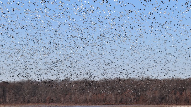
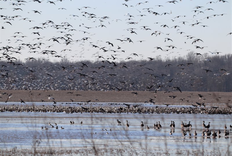
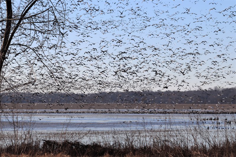
The Waterfowl Report editor made his way to northeast Arkansas to hunt a WRICE field in Poinsett County last weekend, along with a private flooded timber hunt. The freeze up that hit just before the weekend may have submarined the duck chances in both locales. However, snow geese and some greater white-fronted geese (specks) were in great numbers (see photo above).
Saturday morning featured 18-degree temperature and a clear day with barely any ducks flying in our area. Nothing but geese were noted at the WRICE field that afternoon as the temperature warmed. The next day, in the WRICE field, it was 27 degrees, more ice breaking was needed in the field, and perhaps a dozen ducks seen flying in the distance.
However, in a private field with water just to the east of the middle section of Earl Buss Bayou DeView Wildlife Management Area, we witnessed one of the largest assemblages of geese we’ve ever seen. We’d noted early Sunday morning the continuous flights of geese from around the Cache River over to this site. Here are a few more photos below.
In conversations with other hunters who stayed in Newport and tried the area for duck hunting on Saturday, results were poor. On Saturday afternoon it sounded like many waterfowlers were seeking geese in area fields.
Hunters were using the upper Cache River and its overflow areas heavily though on Sunday, we noted. Later, we learned that some private land success was had in the area as well.
We checked in Monday with AGFC biologist Jason Carbaugh, who had flown the area the week before as part of the AGFC’s late January aerial waterfowl survey.
“I flew last Monday and Tuesday. There were several thousand ducks south of Shirey Bay Rainey Brake WMA and St. Francis Sunken Lands WMA in flooded fields where the Black River and St. Francis River got out of its banks,” he said. “These areas had gravel roads and pits under water so access appeared to be difficult to get to the ducks. All these fields were private. The Cache River south of Amagon had a good hotspot with ducks as well. However, after the aerial survey, with the hard freeze with lows in the teens at least three nights in a row, the fields froze up and I’m sure shuffled the ducks around.
“It seems the last three years or more, ducks are responding more and more to hunting pressure. It appears they are holding tight to refuges and private ag reservoirs that are managed as rest areas. It seems they are very nocturnal with feeding at night and loafing on the rest areas during the day.”
Northeast Arkansas
Big Lake WMA
Map | Water Gauge | Weather Report
When the Ditch 81 extension gauge near Manila (upstream of the Big Lake north-end control structure) reads 17.5 feet, water is beginning to come over the north levee degrade on Big Lake WMA. When the Ditch 81 Extension gauge reads 18.0 feet or higher, the water level on the WMA will rise quickly and hunters should exercise caution while on the area. Be aware of underwater logs in boat runs and hangers in trees.
North Woods GTR
Habitat: Mast production is good.
Water Level: Gauge reading at BoDoc is 237.3; target level is 235.5 feet with 100% flooded.
South Woods GTR
Habitat: Mast production is fair.
Water Level: Gauge reading at 7-Mile is 236.2; target level is 234.5 feet with 100% flooded.
Simmons Field
Habitat: Good production of millet and sedge. Native production is good in the north, middle and south fields.
Water Level: 100% coverage.
Reports of a few ducks moving across the area. 85% of woods were iced as of Jan. 24.
Dave Donaldson Black River WMA
Map | Water Gauge | Weather Report
Waterfowl hunters should be aware of hangers and submerged logs within the boat runs and GTRs. Please exercise caution when accessing the area. Please remember to keep boats off the levees so AGFC personnel can access the area. Boats blocking access will be moved. Unattended trailers are not to be left overnight on parking areas. River level Monday, Jan. 24, was 5.99 feet and falling.
Upper Island GTR
Habitat: Mast crop is moderate within the GTRs.
Water Level: Current level is 269.6 feet msl. Target level is 269.5; 100% flooded.
Lower Island GTR
Habitat: Mast crop is moderate within the GTRs.
Water Level: Current level is 268.65 feet msl. Target level is 268.0; 100% flooded.
Upper Reyno GTR
Habitat: Mast crop is moderate within the GTRs.
Water Level: Current level is 267.2 feet msl. Target level is 266.9; 100% flooded.
Lower Reyno GTR
Habitat: Mast crop is moderate within the GTRs.
Water Level: Current level is 266.75 feet msl. Target level is 266.3; 100% flooded.
Winchester GTR
Habitat: Mast crop is moderate within the GTRs.
Water Level: Current level is 263.85 feet msl. Target level is 263.7; 100% flooded.
Earl Buss Bayou DeView WMA
Map | Water Gauge | Weather Report
Boaters should use caution while using the Thompson Tract boat run.
South Oliver GTR
Habitat: Mast production is good.
Water Level: 100% flooded with a gauge reading on Jan. 24 of 1.7 feet.
Thompson Tract GTR
Habitat: Mast production is good.
Water Level: 0% flooded. The Thompson Tract GTR will be allowed to rise and fall naturally without the gates being operated beginning with this season. This action is an effort to help the next generation of forest.
Lake Hogue WRA
Habitat: Primarily deep open water habitat.
Water Level: Normal pool level.
Shirey Bay Rainey Brake WMA
Map | Water Gauge | Weather Report
Waterfowl hunters should be aware of hangers and submerged logs within the boat runs and GTRs. Please exercise caution when accessing the area. In addition, hunters should allow safe passage when parking vehicles along roadsides. Vehicles blocking access will be moved.
Adam Brake GTR
Habitat: Mast production is good.
Water Level: Water level is 240.1 feet msl with a target level of 240.0 feet msl; 100% flooded.
Rainey Brake GTR
Habitat: Mast production is good.
Water Level: 100% flooded.
Eagle Pond GTR
Habitat: Mast production is good.
Water Level: 100% flooded.
Phase III Moist-Soil Unit
Habitat: Good wetland-type vegetation.
Water Level: 98% flooded.
Charles Crisp Moist-Soil Unit
Habitat: Good wetland-type vegetation.
Water Level: 100% flooded.
Ward Field Moist-Soil Unit
Habitat: Good wetland-type vegetation.
Water Level: 100% flooded.
River Field Moist-Soil Unit
Habitat: Good wetland-type vegetation.
Water Level: 100% flooded.
St. Francis Sunken Lands WMA
Map | Water Gauge | Weather Report
Hunt Area
Habitat: Good mast production within the hunt area.
Water Level: Water levels on St. Francis Sunken Lands for waterfowl season are dependent on flows from the St. Francis River. The target level for providing huntable timber is 212.0 feet msl at the Oak Donnick gauge. As of Jan. 24, the reading was 212.65 feet msl.
Snowden WRA
Habitat: Mixed grasses.
Water Level: 30% flooded, mostly in the low-lying areas due to rain.
Payneway WRA
Habitat: A, B, C and D pools have mixed smartweed and barnyard grasses. Moderate mast is available within pools A, B and C as well.
Water Level: Pool A is at 20% coverage. Pool B is at 30%. Pool C is at 50%. Pool D is at 60%.
East-Central Arkansas
Henry Gray Hurricane Lake WMA
Map | Water Gauge | Weather Report
Hunters should call the Wildlife Hotline at 800-440-1477 for current road closures.
North Unit
Habitat: Good mast crop.
Water Level: The White River at Augusta as of Wednesday, Jan. 26, was 25.19 feet and falling. The water level at Glaise Creek is 192 feet msl and falling. All structures on the North GTR will remain open during the 2021-22 season.
South Unit
Habitat: Fair mast crop.
Water Level: The White River at Augusta is 25.19 feet and falling. The water level at Glaise Creek is 192 feet msl and falling. All structures on the South Unit are open.
Rex Hancock Black Swamp WMA
Map | Water Gauge | Weather Report
Hunters should call the Wildlife Hotline at 800-440-1477 for current road closures.
Gregory GTR
Habitat: Good mast crop.
Water Level: 100% (Cache River at Patterson was at 9.14 feet on Jan. 26 and falling.)
Wiville Moist-Soil Unit
Habitat: Good stand of millet and native vegetation.
Water Level: 40% coverage.
Sheffield Nelson Dagmar WMA
Map | Water Gauge | Weather Report
The Conway George units are currently available for hunting by applying for online permits. Youths may apply for Saturday and Sunday hunts, with one adult hunter allowed per one youth, up to four hunters in the blind. Please visit www.agfc.com for maps, special regulations, permit application and draw dates. Hunters should call the Wildlife Hotline at 800-440-1477 for current road closures. The AGFC will not be putting boards in at Dagmar. Water coverage is dependent on river level.
Mud Slough GTR
Habitat: Good mast crop.
Water Level: 90% coverage.
Apple Lake WRA (no hunting)
Habitat: Good mast crop.
Water Level: 90%.
Conway George Waterfowl Unit A
Habitat: Good stand of millet and native vegetation.
Water Level: 100%
Conway George Waterfowl Unit B
Habitat: Natural slough area with beneficial native wetland plants.
Water Level: 100%
Conway George Waterfowl Unit C
Habitat: Good stand of millet and native vegetation.
Water Level: 100%
Dark Corner Waterfowl Unit 1
Habitat: Good stand of millet and native vegetation.
Water Level: 100%
Dark Corner Waterfowl Unit 2
Habitat: Good stand of millet and native vegetation.
Water Level: 40%
Dark Corner Waterfowl Unit 3
Habitat: Good stand of millet and native vegetation.
Water Level: 100%
Steve N. Wilson Raft Creek Bottoms WMA
Hunting in Raft Creek Bottoms WMA requires participation on the online draw a week before the following weekend’s hunt. There is no online draw on Tuesdays and Thursdays, and permits are available at the boat accesses. Permits ARE required (via online application) on weekends, Tuesdays and Thursdays for the youth and mobility-impaired blinds and for the Magellan Tract. Visit agfc.com to apply for the online draw. There will be no designated holes this season.
The White RIver gauge at Georgetown on Wednesday, Jan. 26, was 15.26 feet and falling.
Map | Water Gauge | Weather Report
Unit A
Habitat: Excellent stand of native vegetation.
Water Level: 100% coverage.
Unit B
Habitat: Excellent stand of millet and native vegetation.
Water Level: 100%
Unit C
Habitat: Good stand of native vegetation.
Water Level: 100%
Unit D
Habitat: Good stand of native vegetation.
Water Level: 100%
Unit E
Habitat: Excellent stand of millet and native vegetation.
Water Level: 100%
Unit F (Youth Area)
Habitat: Good stand of millet and native vegetation.
Water Level: 100%
Unit G
Habitat: Fair stand of millet and native vegetation.
Water Level: 100%
Unit H (Mobility-impaired blind)
Habitat: Excellent stand of native vegetation.
Water Level: 100%
Unit I
Habitat: Habitat conditions are poor.
Water Level: 100%
Unit J (Cypert Tract)
Habitat: Excellent stand of native vegetation.
Water Level: 95%
Unit K (Cypert Tract)
Habitat: Excellent stand of native vegetation.
Water Level: 100%
Unit L (Cypert Tract)
Habitat: Fair stand of native vegetation.
Water Level: 100%
Unit M (Magellan Tract)
Habitat: Fair stand of native vegetation.
Water Level: 100%
Central Arkansas
Bell Slough WMA
Map | Weather Report
The Bell Slough GTR is primarily rainfall dependent with the exception of a limited amount of water that the AGFC can back in and catch from Palarm Creek.
Bell Slough GTR
Habitat: Poor mast crop.
Water Level: 100%.
Palarm Creek WRA
Habitat: Fair stand of planted millet.
Water Level: 100%
Craig D. Campbell Lake Conway Reservoir
Map | Weather Report
Habitat and water levels are normal on both Pierce and Dix creeks.
Cypress Bayou WMA
Hunt Area
Habitat:
Good mast crop.
Water Level: 100% coverage.
Red Cut Slough Tract
Unit 1
Habitat:
Habitat conditions are poor.
Water Level: 75%
Unit 2
Habitat:
Excellent stand of millet and native vegatation
Water Level: 75%
Unit 3
Habitat:
Good stand of millet and native vegatation
Water Level: 100%
Unit 4
Habitat: Good stand of millet and native vegetation.
Water Level: 100%
Unit 5
Habitat:
Good stand of native vegetation.
Water Level: 100%
Unit 6
Habitat:
Good stand of native vegetation.
Water Level: 100%
Harris Brake WMA
Upper GTR
Habitat: Below average mast crop.
Water Level: 100%.coverage,
Lower GTR
Habitat: Below average mast crop.
Water Level: 100% coverage. Water is over Steamboat Road.
Holland Bottoms WMA
Hunt Area
Habitat: Good mast crop.
Water Level: 80% coverage.
Lake Pickthorne WRA (no hunting)
Habitat: Excellent crop of native vegetation and millet.
Water Level: East cell is 100%, West cell is 100%.
Northwest Arkansas
Dardanelle WMA
McKennon Bottoms (half-day hunting)
Habitat: Good stand of native vegetation.
Water Level: 100% coverage
Potter’s Pothole Hartman Waterfowl Unit (half-day hunting)
Habitat: West cell has a good stand of Japanese millet. East cell has a poor stand of Japanese millet.
Water Level: 100% coverage
Ed Gordon Point Remove WMA
All waterfowl impoundments remain at or near full pool at this time.
Duck use on the WMA has been moderate and hunter success been poor to fair.
Little Hole (Unit 1)
Habitat: Japanese millet.
Water Level: 100% flooded.
Willow Island (Unit 2)
Habitat: Japanese millet and natural vegetation.
Water Level: 100%
Red Gate (Unit 3)
Habitat: Natural vegetation
Water Level: 100%
Pig Trough (Units 4 and 5)
Habitat: Natural vegetation and Japanese millet.
Water Level: 100%
Cedar Ridge (Unit 6)
Habitat: Natural vegetation.
Water Level: 100%
Unit 7a
Habitat: Natural vegetation.
Water Level: 100%
Unit 7b
Habitat: Japanese millet and natural vegetation.
Water Level: 100%
Duck Trap (Units 8a, 8b and 8c)
8a
Habitat: Natural vegetation.
Water Level: 90%
8b
Habitat: Natural vegetation.
Water Level: 90%
8c
Habitat: Natural vegetation.
Water Level: 90%
Unit 9
Habitat: Japanese millet and natural vegetation.
Water Level: 100%
Controversy Corner (Unit 10)
Habitat: Natural vegetation.
Water Level: 100%
Remmel Marsh
Habitat: Natural vegetation and Japanese millet.
Water Level: 90%
Mud Pond (Unit 12)
Habitat: Natural vegetation and Japanese millet.
Water Level: 100%
Turkey Pond (Units 13a, 13b and 13c)
13a
Habitat: Natural vegetation.
Water Level: 100%
13b
Habitat: Natural vegetation.
Water Level: 90%
13c
Habitat: Natural vegetation.
Water Level: 100%
Teeny Pond (Unit 14)
Habitat: Natural vegetation.
Water Level: 100%
Salt Lick (Unit 15)
Habitat: Natural vegetation.
Water Level: 100%
Bobby’s Pond (Unit 16)
Habitat: Natural vegetation.
Water Level: 100%
Race Track (Unit 17)
Habitat: Natural vegetation.
Water Level: 100%
Frog Bayou WMA
Unit 1
Habitat: Good stand of moist-soil vegetation.
Water Level: 100% coverage
Unit 2
Habitat: Poor stand of moist-soil vegetation.
Water Level: 100% flooded.
Unit 3
Habitat: Good stand of moist-soil vegetation and planted millet.
Water Level: 100%
Unit 4
Habitat: Good stand of moistl-soil vegetation and planted millet
Water Level: 100%
Unit 5
Habitat: Good stand of moist-soil vegetation on the upper end, lower end has been fallow-disked.
Water Level: 100%
Unit 6
Habitat: Good stand of moist-soil vegetation.
Water Level: 80%
Unit 7
Habitat: Good stand of moist-soil vegetation.
Water Level: 100%
Galla Creek WMA
Galla Creek GTR
Habitat: Good stands of native vegetation, including a mixture of barnyard grass, annual smartweeds and sprangletop.
Water Level: 100% flooded. The waterfowl impoundment at Galla Creek WMA is at full pool at this time.
Nimrod Lloyd Millwood WMA
Nimrod GTR
Habitat: The red oak mast crop is poor this year but the desirable native vegetation growth is better than in previous years. This area is rainfall dependent to flood.
Water Level: 50% flooded
Ozark Lake WMA/Dyer Lake Water Unit
Dyer Lake Cells
Units 1 and 2
Habitat: Good stand of moist-soil vegetation and planted millet
Water Level: 100% coverage for both units
Unit 3 South Cell
Habitat: Good stand of moist-soil vegetation and volunteer millet
Water Level: 10% coverage
Unit 4 West Cell (rainfall dependent)
|Habitat: Poor stand of moist-soil vegetation
Dyer West Cell: Less than 25% coverage
Petit Jean River WMA
Map | Water Gauge | Weather Report
Sorehead Moist-Soil Unit
Habitat: Due to ongoing waterfowl habitat enhancement projects, this unit was not able to grow any food this year.
Water Level: 100%
Blacklands Moist-Soil Unit
Habitat: This unit this year contains one of the best stands of desirable native vegetation in recent years. The wooded areas inside the unit produced a poor red oak mast crop this year.
Water Level: 100%.
Slaty Crossing Moist-Soil Unit
Habitat: Due to ongoing waterfowl habitat enhancement projects, this unit was not able to grow a desirable native vegetation crop this year. The area was seeded with millet after the project was completed. The area yielded a great stand of planted millet.
Water Level: 100%
Blacklands Duck Area
Habitat: The wooded sections of this area produced a poor red oak mast crop this year. This area also contains a mix of moderate to great stands of desirable native vegetation mixed throughout.
Water Level: 100%
Pullen Pond Marsh
Habitat: Due to ongoing waterfowl habitat enhancement projects, parts of the central section of this area is bare ground. Most of the area has amazing stands of desirable native vegetation. The desirable native vegetation has started to become more and more prevalent with each year of ongoing management work. This area is rainfall dependent to flood.
Water Level: 75%.
Pond Creek GTR
Habitat: This area produced a poor red oak mast crop this year with good stands of desirable native vegetation in the open lands within this area. The water-control structures were closed on Nov. 16.
Water Level: 10%. Flooding of this area is rainfall dependent.
Slaty GTR
Habitat: This area produced a poor red oak mast crop this year with good stands of desirable native vegetation in the open lands within this area. The water-control structure was closed on Nov. 16.
Water Level: 10%. Flooding of this area is rainfall dependent.
Santa Fe GTR
Habitat: This area produced a lpoor red oak mast crop this year with good stands of desirable native vegetation in the open lands within this area.
Water Level: 100%. Flooding of this area is rainfall dependent.
Southwest Arkansas
Dr. Lester Sitzes III Bois d’Arc WMA
Bois d’Arc Lake WRA
Habitat: Closed to hunting.
Water Level: Normal
Red Slough WRA
Habitat: Closed to hunting.
Water Level: 70% coverage.
GTR
Habitat: Good mast production.
Water Level: 90%. Water control structures were closed Dec. 1.
Little Grassy
Habitat: Good
Water Level: 80%
Millwood Lake
Map | Water Gauge | Weather Report
Habitat: Habitat conditions are good.
Water Level: Millwood is at 259.33 feet msl as of Jan. 26.
Ozan WMA
Flooding of all units is rainfall dependent.
Unit 1
Habitat: Good
Water Level: 5%
Unit 2
Habitat: Good
Water Level: 0%
Unit 3
Habitat: Good
Water Level: 0%
Unit 4
Habitat: Good
Water Level: 0%
Unit 5
Habitat: Good
Water Level: 0%
Sulphur River WMA
Mercer Bayou
Habitat: Fair
Water Level: 40%
Henry Moore WRA
Habitat: Closed to hunting.
Water Level: 75%
Southeast Arkansas
Beryl Anthony Lower Ouachita WMA
Map | Weather Report
Water Level: No duck hunting water. Water is available in the oxbow lakes located in the WMA.
Cut-Off Creek WMA
Map | Weather Report
Hunt Area
Habitat: Habitat conditions are good.
Water Level: Some water in low areas only.
Pigeon Creek WRA
Habitat: Habitat conditions are good.
Water Level: Pumping as water conditions allow.
Freddie Black Choctaw Island WMA Deer Research Area
Map | Water Gauge | Weather Report
Habitat conditions are good. Flooding is river dependent. Click on the Water Gauge link above for current Mississippi River levels. Use extreme caution when boating in river.
The Freddie Black Choctaw Island WMA West Unit allows weekend permit hunting for youths (one adult per youth hunter); on Wednesdays, all ages may apply for a permit to hunt the blinds in the West Unit. Currently, the area is dry and there have been no online draws for the West Unit.
George H. Dunklin Jr. Bayou Meto WMA
Map | Water Gauge | Weather Report
The UGSG is reporting real-time water gauge readings at the headwater at each GTR within the George H. Dunklin Bayou Meto WMA. Click the Water Gauge link above for the WMA, and search for the particular GTR as noted.
NOTE: During the 2021-22 wintering period, all intentional flooding will be held at 179 feet msl, an elevation that will relieve stress on many of trees such as red oaks that are showing signs of distressed. Rain and increased flow into the WMA will allow water to rise above that level periodically, but artificial flooding will be stopped at the 179 feet msl mark. A good rule of thumb for comparing water levels to access into Bayou Meto: 176 feet msl – water breaking into sloughs and lower ditches; 177-177.5 feet msl – water beginning to break out of sloughs and lower ditches; 178 feet msl – water in most sloughs and ditches and entering into lower elevations in woods; 178.5 feet msl – most ditches and sloughs deep enough to boat and most boat ramps become serviceable; 179 feet msl or above – good duck hunting waters.
Upper Vallier GTR
Habitat: Good
Water Level: Water at 179.56 feet msl as of Jan. 26. See Gauge Link (Upper Vallier Headwater) for updated info.
Lower Vallier GTR
Habitat: Good
Water Level: Water at 179.68 feet msl as of Jan. 26. See Gauge Link (Lower Vallier Headwater) for updated info.
Government Cypress GTR
Habitat: Good
Water Level: Water at 179.86 feet msl as of Jan. 26. See Gauge Link (Government Cypress Headwater) for updated info.
Buckingham Flats GTR
Habitat: Good
Water Level: Full pool. Water level at 177.91 feet as of Jan. 26. See Gauge Link (Buckingham Flats Headwater) for updated info.
Temple Island GTR
Habitat: Good
Water Level: Full pool. Water level at 184.42 feet as of Jan. 26. See Gauge Link (Temple Island Headwater) for updated info.
Canon Brake
Habitat: Good
Water Level: Water at 177.49 feet msl on Jan. 26. See Gauge Link (Canon Brake Headwater) for updated info.
Halowell WRA
Habitat: Excellent
Water Level: Staggered flooding of units.
Wrape Plantation WRA
Habitat: Excellent
Water Level: Staggered flooding of units.
Seven Devils WMA
Hunt Area
Habitat: Habitat conditions are good.
Water Level: Water is running over east side spillway.
Trusten Holder WMA
Map | Water Gauge | Weather Report
Habitat conditions are good. Flooding is river dependent. Click on the Water Gauge link above for current Arkansas River levels.
Recent News
Arkansas Wildlife Weekly Fishing Report
Apr. 25, 2024

Subscribe to Our Weekly Newsletter E-mails
Don’t miss another issue. Sign up now to receive the AGFC Wildlife Weekly Newsletter in your mailbox every Wednesday afternoon (Waterfowl Reports are published weekly during waterfowl season and periodically outside the season). Fishing Reports arrive on Thursdays. Fill in the following fields and hit submit. Thanks, and welcome!