Arkansas Wildlife Waterfowl Report
BY Jim Harris
ON 12-29-2021
Dec. 29, 2021
Jim Harris
Managing Editor Arkansas Wildlife Magazine
Hunters Hopeful for Latest Push of Winter-like Weather
LITTLE ROCK – As this week’s Waterfowl Report was being composed Wednesday morning, an usual sight was occurring: A steady rain was falling. Tha’s the best news for duck hunters in some time around these parts. The hope among most hunters is that this first line of rain passing through Arkansas at midweek won’t be the end of it, and maybe at some point over the weekend, winter’s temperatures will finally arrive, too, pushing out the lingering mid-autumn conditions.
Dry and warm are words that don’t equate to good duck hunting, and that’s being experienced in neighboring states as well.
The AGFC’s December aerial survey of waterfowl revealed the second lowest number of mallards and all ducks since the surveys began in 2009. The survey team will be back in the air on Monday, Jan. 3, through midweek next week to see if anything has improved.
Arkansas’s neighbors don’t seem to be faring any better in overall expected duck numbers and mallard numbers, based on their recent surveys.
The Mississippi Department of Wildlife, Fisheries and Parks had its waterfowl aerial survey team in the sky Dec. 13-16, finding that “Wetland habitat availability was again well below average for much of the Mississippi Delta, with very little rainfall occurring since the November survey.” Like Arkansas, shallow, seasonal water was still not widely distributed, and much opportunity remained for private landowners to capture rainfall with water control structures as fall and winter continued. In Mississippi, flooded habitat availability was greatest in the northeast portion of the Delta. As a result, total duck abundance estimate for the Mississippi Delta was below the long-term average for December surveys, as were the individual estimates for mallards and other dabbling ducks.
If your desire was for diving ducks, like ringnecks, those estimates were well above their long-term average for this time of year; divers made up about 50% of all duck observations.
Interesting, in some precision-leveled fields with a little water in east-central Arkansas, just south of Lodge’s Corner, observers noted those fields being covered up in diving ducks rather than dabblers.
Mississippi’s count showed 26,403 estimated mallards, well below the average of 129,134 usually seen there in December; total dabblers were 151,460, below the usual 278,941 ducks typically counted in December; and divers numbered 177,615, or well above the average December estimate of 128,339. The total count of 355,478 was well below the usual 536,414 total ducks in December in counts going back to 2007, a drop of 33.7 percent.
Missouri’s report from the same week, Dec. 13, revealed little change from its report two weeks earlier and noted unseasonably warm temperatures and the need of precipitation, with about 38 percent of the state “abnormally dry.” “Good habitat continues to be limited due the lack of rain and with dry conditions ducks have little reason to pioneer from refuges or other undisturbed areas in search of food,” Andy Raedeke’s report read. A cold front Dec. 6-8 failed to push in an influx of new ducks, he added.
Raedeke wrote: “Managers did not report any significant duck migrations over the past two weeks. The statewide tally for this week was 888,718 ducks, 491,722 snow geese, 37,885 white-fronted geese, and 5,652 Canada geese. The count of 888,718 ducks was similar to the 853,692 counted two weeks ago, 29% higher than last year, 8% higher than the previous five-year average, and 32% higher than the previous 20-year average for this time of year. Our estimate of 592,333 mallards was 14% below the previous five-year average of 691,667 mallards and similar to the previous 20-year average of 563,508 mallards. Mallards comprised 67% of the total ducks compared to 72% last year, 84% for the previous 5-year average, and 84% for the previous 20-year average.”
Missouri typically reaches statewide peak duck numbers during the last week of November and the first week of December, and has reached that peak at that time 10 of the past 20 years, reaching it later in December only three times. Southeastern Missouri should at times see slight increases in ducks later in the season, and its season runs concurrent with Arkansas’s.
* * *
In lieu of any better duck numbers, we turn to the National Weather Service for hopes of better finish to the 2021-22 season. The potential for strong to severe thunderstorms was expected through Wednesday evening and again Friday evening through Saturday morning, although actual rainfall total predictions were not forthcoming.
Jason “Buck Jackson, the AGFC’s wetlands program coordinator, said the state was in need of a lengthy 4-inch-or-more rain event to bring the duck habitat up to a level that would be more inviting to migrating waterfowl.
“It’s the same deal it’s been. We need a fast 4-inch rain. That way we get some runoff,” Jackson said Wednesday as the latest storm front approached central Arkansas.
Water, more than colder weather, has been the biggest need, biologists say. But a stronger cold front and upper-level storm system will approach central Arkansas on Friday, which would provide another opportunity for strong to severe thunderstorms to develop, according to the NWS. So, Arkansas might get the rainfall it needs, but most waterfowlers also know that ducks tend to scurry on in front of heavy thunderstorms. Windy conditions will be seen across the state in advance of and behind the front Friday, with wind guys possibly approaching 30 mph Friday and Saturday, the NWS says. Cold air will rapidly build in behind the front with Sunday morning lows falling into the teens and 20s across much of Arkansas. When northwest winds are factored in, the NWS reports, wind child values could be as cold as 0 degrees to minus-5 degrees across northern Arkansas.
* * *
Four of the six units in Red Cut Slough at Cypress Bayou Wildlife Management area have been pumped up to 85 percent water coverage as of earlier this week, according to the AGFC’s Jacob Bokker. Red Cut Slough hunting is available via permit, and for weekends hunters must acquire the permit through the AGFC’s online draw system. Tuesday and Thursday hunting is available by permits obtained onsite. Cypress Bayou has some huntable water and is available all week without a permit.
Hunters are still awaiting more water to make George H. Dunklin Bayou Meto WMA more huntable (or to spread out the hunters more to make it a better hunt, especially on weekends). The AGFC’s Mark Hooks reported Tuesday, “The Bayou Meto main GTR area is generally holding at 178.4 feet msl or so as of Tuesday afternoon, with the possibility that this next rainfall would improve that.” At 179 feet msl, Bayou Meto has “good huntable water” and all the boat ramps are accessible.
* * *
Remember that to participate or land a permit for either the AGFC’s managed waterfowl areas that offer permit hunting or to enter the drawing for an Arkansas WRICE program field for Saturday and Sunday, Jan. 1-2, you’ll need to apply this week between Thursday at 3 p.m. and Sunday at midnight. This also includes permitted days on WMAs during the week of Jan. 4-6. Permit hunts are offered on Steve N. Wilson Raft Creek Bottoms WMA, the Red Cut Slough tract at Cypress Bayou WMA, the Conway George tract at Sheffield Nelson Dagmar WMA and Freddie Black Choctaw Island West Unit WMA. And AGFC has up to 45 privately owned flooded rice fields available to hunt by permit through its special duck hunting application process via the Arkansas WRICE program. Most of the landowners in the WRICE program who had blinds on-site have upgraded the blinds for a better hunting experience.
Visit https://www.agfc.com/en/hunting/migratory-birds/waterfowl/special-waterfowl-permit-hunts to learn more about these special duck-hunting opportunities and to apply.
* * *
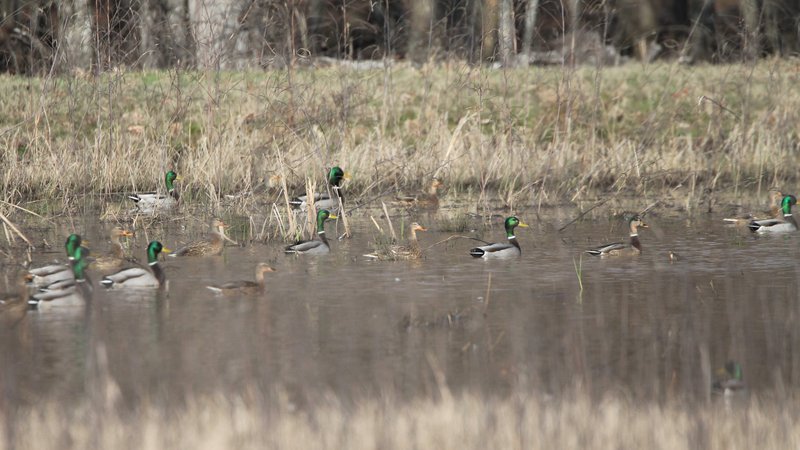
In the undated photo at the top of this page by AGFC photographer Mike Wintroath, mallards seek refuge from hunters and some moist-soil habitat and needed nutrients in the Wrape Plantatation rest area south of George H. Dunklin Bayou Meto Wildlife Management Area.
Northeast Arkansas
Big Lake WMA
Map | Water Gauge | Weather Report
When the Ditch 81 extension gauge near Manila (upstream of the Big Lake north-end control structure) reads 17.5 feet, water is beginning to come over the north levee degrade on Big Lake WMA. When the Ditch 81 Extension gauge reads 18.0 feet or higher, the water level on the WMA will rise quickly and hunters should exercise caution while on the area. Be aware of underwater logs in boat runs and hangers in trees.
North Woods GTR
Habitat: Mast production is good.
Water Level: Gauge reading at BoDoc on Monday was 237.1 feet msl; target level is 235.5 feet with 100% flooded.
South Woods GTR
Habitat: Mast production is fair.
Water Level: Reading at the 7-Mile gauge on Monday was 236.1 feet msl; target level is 234.5 feet with 100% flooded.
Simmons Field
Habitat: Good production of millet and sedge. Native production is good in the north, middle and south fields.
Water Level: 100% coverage.
Reports of a few ducks moving across the area.
Dave Donaldson Black River WMA
Map | Water Gauge | Weather Report
Waterfowl hunters should be aware of hangers and submerged logs within the boat runs and GTRs. Please exercise caution when accessing the area. Please remember to keep boats off the levees so AGFC personnel can access the area. Boats blocking access will be moved. Unattended trailers are not to be left overnight on parking areas. River level is 10.31 feet and holding.
Upper Island GTR
Habitat: Mast crop is moderate within the GTRs.
Water Level: Gauge is inaccessible due to high water. Target level is 269.5; 100% flooded.
Lower Island GTR
Habitat: Mast crop is moderate within the GTRs.
Water Level: Gauge is inaccessible due to high water. Target level is 268.0; 100% flooded.
Upper Reyno GTR
Habitat: Mast crop is moderate within the GTRs.
Water Level: Current level is 268.2 feet msl. Target level is 266.9; 100% flooded.
Lower Reyno GTR
Habitat: Mast crop is moderate within the GTRs.
Water Level: Current level is 267.75 msl. Target level is 266.3; 100% flooded.
Winchester GTR
Habitat: Mast crop is moderate within the GTRs.
Water Level: Current level is 264.85 feet msl. Target level is 263.7; 100% flooded.
Earl Buss Bayou DeView WMA
Map | Water Gauge | Weather Report
Boaters should use caution while using the Thompson Tract boat run.
South Oliver GTR
Habitat: Mast production is good.
Water Level: 10% flooded. Most water is located within the natural slough on the north end of this GTR.
Thompson Tract GTR
Habitat: Mast production is good.
Water Level: 0% flooded. The Thompson Tract GTR will be allowed to rise and fall naturally without the gates being operated beginning with this season. This action is an effort to help the next generation of forest.
Lake Hogue WRA
Habitat: Primarily deep open water habitat.
Water Level: Normal pool level.
Shirey Bay Rainey Brake WMA
Map | Water Gauge | Weather Report
Waterfowl hunters should be aware of hangers and submerged logs within the boat runs and GTRs. Please exercise caution when accessing the area. In addition, hunters should allow safe passage when parking vehicles along roadsides. Vehicles blocking access will be moved.
Adam Brake GTR
Habitat: Mast production is good.
Water Level: Water level is 239.8 feet msl with a target level of 240.0 feet msl; 90% flooded.
Rainey Brake GTR
Habitat: Mast production is good.
Water Level: 100% flooded.
Eagle Pond GTR
Habitat: Mast production is good.
Water Level: 95% flooded.
Phase III Moist-Soil Unit
Habitat: Good wetland-type vegetation.
Water Level: 75% flooded.
Charles Crisp Moist-Soil Unit
Habitat: Good wetland-type vegetation.
Water Level: 100% flooded.
Ward Field Moist-Soil Unit
Habitat: Good wetland-type vegetation.
Water Level: 100% flooded.
River Field Moist-Soil Unit
Habitat: Good wetland-type vegetation.
Water Level: 100% flooded.
St. Francis Sunken Lands WMA
Map | Water Gauge | Weather Report
Hunt Area
Habitat: Good mast production within the hunt area.
Water Level: Water levels on St. Francis Sunken Lands for waterfowl season are dependent on flows from the St. Francis River. The target level for providing huntable timber is 212.0 feet msl at the Oak Donnick gauge. As of Dec. 27, the reading was 213.14 feet msl.
Snowden WRA
Habitat: Mixed grasses.
Water Level: 10% flooded, mostly in the low-lying areas due to rain.
Payneway WRA
Habitat: A, B, C and D pools have mixed smartweed and barnyard grasses. Moderate mast is available within pools A, B and C as well.
Water Level: Pool A is at 0% coverage. Pool B is at 0%. Pool C is at 0%. Pool D is at 5%.
East-Central Arkansas
Henry Gray Hurricane Lake WMA
Map | Water Gauge | Weather Report
Hunters should call the Wildlife Hotline at 800-440-1477 for current road closures.
North Unit
Habitat: Good mast crop.
Water Level: The White River at Augusta as of Dec. 28 was 23.5 feet and falling. All structures on the North GTR will remain open during the 2021-22 season.
South Unit
Habitat: Fair mast crop.
Water Level: The White River at Augusta as of Dec. 28 was 23.5 feet and falling. All structures on the South Unit are open.
Rex Hancock Black Swamp WMA
Map | Water Gauge | Weather Report
Hunters should call the Wildlife Hotline at 800-440-1477 for current road closures.
Gregory GTR
Habitat: Good mast crop.
Water Level: 80% (Cache River at Patterson was at 9.9 feet as of Dec. 28 and starting to fall.
Wiville Moist-Soil Unit
Habitat: Good stand of millet and native vegetation.
Water Level: 10% coverage.
Sheffield Nelson Dagmar WMA
Map | Water Gauge | Weather Report
The Conway George units are currently available for hunting by applying for online permits. Youths may apply for Saturday and Sunday hunts, with one adult hunter allowed per one youth, up to four hunters in the blind. All ages may apply for Wednesday hunts. Please visit www.agfc.com for maps, special regulations, permit application and draw dates. Hunters should call the Wildlife Hotline at 800-440-1477 for current road closures. The AGFC will not be putting boards in at Dagmar. Water coverage is dependent on river level.
Mud Slough GTR
Habitat: Good mast crop.
Water Level: 0% coverage.
Apple Lake WRA (no hunting)
Habitat: Good mast crop.
Water Level: 30%.
Conway George Waterfowl Unit A
Habitat: Good stand of millet and native vegetation.
Water Level: 100%
Conway George Waterfowl Unit B
Habitat: Natural slough area with beneficial native wetland plants.
Water Level: 100%
Conway George Waterfowl Unit C
Habitat: Good stand of millet and native vegetation.
Water Level: 100%
Dark Corner Waterfowl Unit 1
Habitat: Good stand of millet and native vegetation.
Water Level: 50%
Dark Corner Waterfowl Unit 2
Habitat: Good stand of millet and native vegetation.
Water Level: 30%
Dark Corner Waterfowl Unit 3
Habitat: Good stand of millet and native vegetation.
Water Level: 90%
Steve N. Wilson Raft Creek Bottoms WMA
Hunting in Raft Creek Bottoms WMA requires participation on the online draw a week before the following weekend’s hunt. There is no online draw on Tuesdays and Thursdays, and permits are available at the boat accesses. Permits ARE required (via online application) on weekends, Tuesdays and Thursdays for the youth and mobility-impaired blinds and for the Magellan Tract. Visit agfc.com to apply for the online draw. There will be no designated holes this season.
Map | Water Gauge | Weather Report
Unit A
Habitat: Excellent stand of native vegetation.
Water Level: 90% coverage.
Unit B
Habitat: Excellent stand of millet and native vegetation.
Water Level: 70%
Unit C
Habitat: Good stand of native vegetation.
Water Level: 85%
Unit D
Habitat: Good stand of native vegetation.
Water Level: 85%
Unit E
Habitat: Excellent stand of millet and native vegetation.
Water Level: 85%
Unit F (Youth Area)
Habitat: Good stand of millet and native vegetation.
Water Level: 100%
Unit G
Habitat: Fair stand of millet and native vegetation.
Water Level: 0%
Unit H (Mobility-impaired blind)
Habitat: Excellent stand of native vegetation.
Water Level: 100%
Unit I
Habitat: Habitat conditions are poor.
Water Level: 0%
Unit J (Cypert Tract)
Habitat: Excellent stand of native vegetation.
Water Level: 90%
Unit K (Cypert Tract)
Habitat: Excellent stand of native vegetation.
Water Level: 10%
Unit L (Cypert Tract)
Habitat: Fair stand of native vegetation.
Water Level: 0%
Unit M (Magellan Tract)
Habitat: Fair stand of native vegetation.
Water Level: 60%
Central Arkansas
Bell Slough WMA
Map | Weather Report
The Bell Slough GTR is primarily rainfall dependent with the exception of a limited amount of water that the AGFC can back in and catch from Palarm Creek.
Bell Slough GTR
Habitat: Poor mast crop.
Water Level: 100%.
Palarm Creek WRA
Habitat: Fair stand of planted millet.
Water Level: 85%
Craig D. Campbell Lake Conway Reservoir
Map | Weather Report
Habitat and water levels are normal on both Pierce and Dix creeks.
Cypress Bayou WMA
Hunt Area
Habitat:
Good mast crop.
Water Level: 60% coverage.
Red Cut Slough Tract
Unit 1
Habitat:
Habitat conditions are poor.
Water Level: 0%
Unit 2
Habitat:
Excellent stand of millet and native vegatation
Water Level: 0%
Unit 3
Habitat:
Good stand of millet and native vegatation
Water Level: 85%
Unit 4
Habitat: Good stand of millet and native vegetation.
Water Level: 85%
Unit 5
Habitat:
Good stand of native vegetation.
Water Level: 85%
Unit 6
Habitat:
Good stand of native vegetation.
Water Level: 75%
Harris Brake WMA
Upper GTR
Habitat: Below average mast crop.
Water Level: 100%.coverage,
Lower GTR
Habitat: Below average mast crop.
Water Level: 100% coverage. Water is over Steamboat Road.
Holland Bottoms WMA
Hunt Area
Habitat: Good mast crop.
Water Level: 5% coverage.
Lake Pickthorne WRA (no hunting)
Habitat: Excellent crop of native vegetation and millet.
Water Level: East cell is 90%, West cell is 100%.
Northwest Arkansas
Dardanelle WMA
McKennon Bottoms (half-day hunting)
Habitat: Good stand of native vegetation.
Water Level: 100% coverage
Potter’s Pothole Hartman Waterfowl Unit (half-day hunting)
Habitat: West cell has a good stand of Japanese millet. East cell has a poor stand of Japanese millet.
Water Level: 100% coverage
Ed Gordon Point Remove WMA
Recent rainfall events have slightly improved conditions on Ed Gordon Point Remove WMA, and pumping of
waterfowl impoundments continues.
Duck use and hunter success on the WMA have remained generally poor.
Little Hole (Unit 1)
Habitat: Japanese millet.
Water Level: 80% flooded.
Willow Island (Unit 2)
Habitat: Japanese millet and natural vegetation.
Water Level: 90%
Red Gate (Unit 3)
Habitat: Natural vegetation
Water Level: 80%
Pig Trough (Units 4 and 5)
Habitat: Natural vegetation and Japanese millet.
Water Level: 50%
Cedar Ridge (Unit 6)
Habitat: Natural vegetation.
Water Level: 80%
Unit 7a
Habitat: Natural vegetation.
Water Level: 90%
Unit 7b
Habitat: Japanese millet and natural vegetation.
Water Level: 0%
Duck Trap (Units 8a, 8b and 8c)
8a
Habitat: Natural vegetation.
Water Level: 80%
8b
Habitat: Natural vegetation.
Water Level: 90%
8c
Habitat: Natural vegetation.
Water Level: 70%
Unit 9
Habitat: Japanese millet and natural vegetation.
Water Level: 90%
Controversy Corner (Unit 10)
Habitat: Natural vegetation.
Water Level: 65%
Remmel Marsh
Habitat: Natural vegetation and Japanese millet.
Water Level: 50%
Mud Pond (Unit 12)
Habitat: Natural vegetation and Japanese millet.
Water Level: 90%
Turkey Pond (Units 13a, 13b and 13c)
13a
Habitat: Natural vegetation.
Water Level: 40%
13b
Habitat: Natural vegetation.
Water Level: 0%
13c
Habitat: Natural vegetation.
Water Level: 90%
Teeny Pond (Unit 14)
Habitat: Natural vegetation.
Water Level: 0%
Salt Lick (Unit 15)
Habitat: Natural vegetation.
Water Level: 55%
Bobby’s Pond (Unit 16)
Habitat: Natural vegetation.
Water Level: 65%
Race Track (Unit 17)
Habitat: Natural vegetation.
Water Level: 100%
Frog Bayou WMA (half-day hunting)
Unit 1
Habitat: Good stand of moist-soil vegetation.
Water Level: 100% coverage
Unit 2
Habitat: Poor stand of moist-soil vegetation.
Water Level: 25% or less flooded.
Unit 3
Habitat: Good stand of moist-soil vegetation and planted millet.
Water Level: 100%
Unit 4
Habitat: Good stand of moistl-soil vegetation and planted millet
Water Level: 100%
Unit 5
Habitat: Good stand of moist-soil vegetation on the upper end, lower end has been fallow-disked.
Water Level: 100%
Unit 6
Habitat: Good stand of moist-soil vegetation.
Water Level: 50%, and pumping will resume after repairs are made to the pump.
Unit 7
Habitat: Good stand of moist-soil vegetation.
Water Level: 100%
Galla Creek WMA
Galla Creek GTR
Habitat: Good stands of native vegetation, including a mixture of barnyard grass, annual smartweeds and sprangletop.
Water Level: 65% flooded. Staged flooding of the impoundment began on Nov. 15.
Nimrod Lloyd Millwood WMA
Nimrod GTR
Habitat: The red oak mast crop is poor this year but the desirable native vegetation growth is better than in previous years. Due to abnormally dry conditions, this area is not expected to fill up as fast as in previous years. The water-control structures were closed on Nov. 17. This area is rainfall dependent to flood.
Water Level: 10% flooded
Ozark Lake WMA/Dyer Lake Water Unit
Dyer Lake Cells (half-day hunting)
Units 1 and 2
Habitat: Good stand of moist-soil vegetation and planted millet
Water Level: 100% coverage for both units
Unit 3 South Cell
Habitat: Good stand of moist-soil vegetation and volunteer millet
Water Level: 10% coverage
Unit 4 West Cell (rainfall dependent)
|Habitat: Poor stand of moist-soil vegetation
Dyer West Cell: Less than 25% coverage
Petit Jean River WMA
Map | Water Gauge | Weather Report
Sorehead Moist-Soil Unit
Habitat: Due to ongoing waterfowl habitat enhancement projects, this unit was not able to grow any food this year. Work is still ongoing as long as this area stays dry. The Kingfisher Lake water-control structure valve was opened on Nov. 17 to help flood this area.
Water Level: 50%
Blacklands Moist-Soil Unit
Habitat: This unit this year contains one of the best stands of desirable native vegetation in recent years. The wooded areas inside the unit produced a poor red oak mast crop this year. Due to abnormally dry conditions and low river levels, this area is not expected to fill up as fast as in previous years. The river level is still too low to properly pump.
Water Level: 20%.
Slaty Crossing Moist-Soil Unit
Habitat: Due to ongoing waterfowl habitat enhancement projects, this unit was not able to grow a desirable native vegetation crop this year. The area was seeded with millet after the project was completed. The area yielded a great stand of planted millet. Due to abnormally dry conditions and low river levels, this area is not expected to fill up as fast as in previous years. The pump was started on Nov. 17 but will not be run continuously this year due to the lack of adequate water in the river.
Water Level: 95%
Blacklands Duck Area
Habitat: The wooded sections of this area produced a poor red oak mast crop this year. This area also contains a mix of moderate to great stands of desirable native vegetation mixed throughout. The Kingfisher Lake water-control structure valve was opened on Nov. 17 to help flood this area.
Water Level: 60%
Pullen Pond Marsh
Habitat: Due to ongoing waterfowl habitat enhancement projects, parts of the central section of this area is bare ground. Most of the area has amazing stands of desirable native vegetation. The desirable native vegetation has started to become more and more prevalent with each year of ongoing management work. Work is still ongoing until the area becomes too wet to work. This area is rainfall dependent to flood.
Water Level: 5%.
Pond Creek GTR
Habitat: This area produced a poor red oak mast crop this year with good stands of desirable native vegetation in the open lands within this area. Due to abnormally dry conditions, this area is not expected to fill up as fast as in previous years. The water-control structures were closed on Nov. 16. This area is rainfall dependent to flood.
Water Level: 0%. Flooding of this area is rainfall dependent.
Slaty GTR
Habitat: This area produced a poor red oak mast crop this year with good stands of desirable native vegetation in the open lands within this area. Due to abnormally dry conditions, this area is not expected to fill up as fast as in previous years. The water-control structure was closed on Nov. 16.
Water Level: 0%. Flooding of this area is rainfall dependent.
Santa Fe GTR
Habitat: This area produced a lpoor red oak mast crop this year with good stands of desirable native vegetation in the open lands within this area. Due to abnormally dry conditions, this area is not expected to fill up as fast as in previous years. The water-control structures were closed on Nov. 16.
Water Level: 0%. Flooding of this area is rainfall dependent.
Southwest Arkansas
Dr. Lester Sitzes III Bois d’Arc WMA
Bois d’Arc Lake WRA
Habitat: Closed to hunting.
Water Level: Normal
Red Slough WRA
Habitat: Closed to hunting.
Water Level: 60% coverage.
GTR
Habitat: Good mast production.
Water Level: 70%. Water control structures were closed Dec. 1.
Little Grassy
Habitat: Good
Water Level: 60%
Millwood Lake
Map | Water Gauge | Weather Report
Habitat: Habitat conditions are good.
Water Level: Millwood is at 259.6 feet msl as of Dec. 28
Ozan WMA
Flooding of all units is rainfall dependent.
Unit 1
Habitat: Good
Water Level: 0%
Unit 2
Habitat: Good
Water Level: 0%
Unit 3
Habitat: Good
Water Level: 0%
Unit 4
Habitat: Good
Water Level: 0%
Unit 5
Habitat: Good
Water Level: 0%
Sulphur River WMA
Mercer Bayou
Habitat: Fair
Water Level: 30%
Henry Moore WRA
Habitat: Closed to hunting.
Water Level: 65%
Southeast Arkansas
Beryl Anthony Lower Ouachita WMA
Map | Weather Report
Water Level: No duck-hunting water. Water is available in the oxbow lakes located in the WMA. NOTE: While there were reports to AGFC biologists that Felsenthal was on a gradual rise of 1/10 foot per day in the GTR, a graphing Tuesday didn’t appear to show it rising at that rate.
Cut-Off Creek WMA
Hunt Area
Habitat: Habitat conditions are good.
Water Level: Some water in low areas only.
Pigeon Creek WRA
Habitat: Habitat conditions are good.
Water Level: Pumping as water conditions allow.
Freddie Black Choctaw Island WMA Deer Research Area
Map | Water Gauge | Weather Report
Habitat conditions are good. Flooding is river dependent. Click on the Water Gauge link above for current Mississippi River levels. Use extreme caution when boating in river.
The Freddie Black Choctaw Island WMA West Unit allows weekend permit hunting for youths (one adult per youth hunter); on Wednesdays, all ages may apply for a permit to hunt the blinds in the West Unit. Currently, the area is dry and there have been no online draws for the West Unit.
George H. Dunklin Jr. Bayou Meto WMA
Map | Water Gauge | Weather Report
The UGSG is reporting real-time water gauge readings at the headwater at each GTR within the George H. Dunklin Bayou Meto WMA. Click the Water Gauge link above for the WMA, and search for the particular GTR as noted.
The Bayou Meto main GTR area is generally holding at 178.4 feet msl or so as of Tuesday afternoon, with the possibility that this next rainfall would improve that.
During the 2021-22 wintering period, all intentional flooding will be held at 179 feet msl, an elevation that will relieve stress on many of trees such as red oaks that are showing signs of distressed. Rain and increased flow into the WMA will allow water to rise above that level periodically, but artificial flooding will be stopped at the 179 feet msl mark. A good rule of thumb for comparing water levels to access into Bayou Meto: 176 feet msl – water breaking into sloughs and lower ditches; 177-177.5 feet msl – water beginning to break out of sloughs and lower ditches; 178 feet msl – water in most sloughs and ditches and entering into lower elevations in woods; 178.5 feet msl – most ditches and sloughs deep enough to boat and most boat ramps become serviceable; 179 feet msl or above – good duck hunting waters.
Upper Vallier GTR
Habitat: Good
Water Level: See Gauge Link (Upper Vallier Headwater)
Lower Vallier GTR
Habitat: Good
Water Level: See Gauge Link (Lower Vallier Headwater).
Government Cypress GTR
Habitat: Good
Water Level: See Gauge Link (Government Cypress Headwater)
Buckingham Flats GTR
Habitat: Good
Water Level: Pumping as water conditions allow. See Gauge Link (Buckingham Flats Headwater).
Temple Island GTR
Habitat: Good
Water Level: Pumping as water conditions allow. See Gauge Link (Temple Island Headwater).
Canon Brake
Habitat: Good
Water Level: See Gauge Link (Canon Brake Headwater).
Halowell WRA
Habitat: Excellent
Water Level: Staggered flooding of units.
Wrape Plantation WRA
Habitat: Excellent
Water Level: Staggered flooding of units.
Seven Devils WMA
Hunt Area
Habitat: Habitat conditions are good.
Water Level: Some water in lower areas and getting a little higher in the west boat ditch.
Trusten Holder WMA
Map | Water Gauge | Weather Report
Habitat conditions are good. Flooding is river dependent. Click on the Water Gauge link above for current Arkansas River levels.
Recent News
Arkansas Wildlife Weekly Fishing Report
Apr. 18, 2024
Subscribe to Our Weekly Newsletter E-mails
Don’t miss another issue. Sign up now to receive the AGFC Wildlife Weekly Newsletter in your mailbox every Wednesday afternoon (Waterfowl Reports are published weekly during waterfowl season and periodically outside the season). Fishing Reports arrive on Thursdays. Fill in the following fields and hit submit. Thanks, and welcome!