Arkansas Wildlife Waterfowl Report
BY Jim Harris
ON 01-06-2021
Jan. 6, 2021
Jim Harris
Managing Editor Arkansas Wildlife Magazine
Rainfall Throws a Curve; Habitat Improved but Duck Sightings Slim
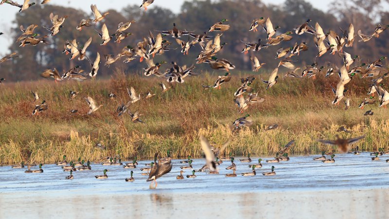
LITTLE ROCK – While Arkansas experienced more rain last week than what it saw in a dry late fall/early winter, the expected flooding for the duck habitat in much of the state didn’t reach expectations, according to Luke Naylor, Arkansas Game and Fish Commission waterfowl program coordinator.
“That rain system did not do what was predicted,” he said. “There were predictions at one point for a pretty extensive, 4- to 6-inch rain band, and if you watched that thing, the storm kind of turned on its axis and everything shifted south of (Interstate) 40. I had expected the Arkansas River Valley, a lot of those agriculture fields around Ed Gordon (Point Remove WMA) and Petit Jean to get overbank flooding for the first time, but that didn’t happen. They didn’t get much, or at least not enough.
“The northeast got some rain, and it definitely doesn’t hurt anything to have some rain, but I don’t know that much of this is going to stick around even now. There wasn’t enough in the Ozarks to make it where the White River will take a major jump anytime soon. Looking long term, there doesn’t seem to be anything on the way. You need a 4-, 5-, 6-inch rain up in the watershed of these areas and I just don’t see it coming.”
North of Arkansas, reports from Missouri indicate The Show Me State has suffered drought conditions in some northern areas, and like Arkansas much of the state was drier than expected this time of year.
Along with the lack of available habitat is a delay in any major migration of ducks, particularly mallards. Anecdotal reports much further north of here say observers are just now seeing their expected influx of winter-migrating ducks in areas of eastern Nebraska. Hunting has ended in such states as South Dakota, and this week marks the end of hunting in Missouri’s northernmost zone (of three zones). Missouri’s south zone, like all of Arkansas, hunts until Jan. 31, and ground duck counts in conservation areas in Bootheel region show less than 60,000 ducks, according to the Missouri Department of Conservation. Missouri’s larger duck counts at the end of December came from conservation areas and national wildlife refuges in the middle and western portions of the state, with small numbers seen near the Mississippi River areas. Its statewide total as of Dec. 31 was 501,402 ducks, down about 200,000 from two weeks earlier and on par with the 20-year average of 495,951, but lower than the previous 5-year average of 674,512 ducks. Mallards in Missouri for the late December count were down 12 percent from the 20-year average and 35 percent below the previous 5-year average.
Quite a bit of Arkansas hunter success seems to hinge on the weather from the breeding grounds on down the flyways, and along with the dry conditions in this region, the entire Mid-Continent covering the Central and Mississippi flyways has seen unusually higher temperatures for late fall/early winter. It remains to be seen if blizzard conditions in Minnesota and northwest Iowa at Christmastime, plus a continued snow storm in Iowa through Dec. 29, will push more ducks down.
As for duck sightings in state, the AGFC has an aerial survey team of biologists out around the state this week for the first of two scheduled January surveys. Anecdotally from what he’s been told, Naylor said, “I’ve heard early reports from the aerial surveys that don’t indicate a dramatic increase in ducks, for sure.” The survey taken Dec. 7-10 showed significantly fewer ducks in the state than are seen at that point, with mallard totals being more than 50 percent below the usual count. Total ducks were under 700,000 where one would expect well over 1 million. Depending on flying weather this week, results from this latest survey could arrive as early as Friday.
The counters may see a lot more water than they saw in early December, but it’s not going to be the great expanse of sheetwater on the Delta fields that is typical for January in Arkansas, Naylor indicated. “I’ve seen some places where water was good and on New Year’s Day I took a drive to the Black River where water was already going into the ditches and the fields were already drying up. Less than 24 hours after the rain ended they were clearly drying up.”
South Arkansas got a needed good drenching, but Naylor said that while George H. Dunklin Bayou Meto WMA as at full water now, “the hunting succes is poor.”
The ducks might have briefly gotten out searching for new habitat, he said, but they found that habitat quickly disappeared and were back into the waterfowl rest areas and sancturaries. “They’re in a pattern. There is not a lot of new resources to go look for, so why would a duck change its pattern where there is not a lot to look for and they have what they need in the sanctuary areas with no pressure? There’s not a lot of incentive to go look for new resources. If they get out they are feeding at night, nocturnal feeding, to find stuff. They just get locked into a pattern and have no reason to go look for anything new because there is not a lot of new out there.”
Managed public areas have seen near complete flooding in the past week, including Rex Hancock Black Swamp WMA and Earl Buss Bayou DeView WMA, both at 100 percent coverage. All units now are at 100 percent flooded in Sheffield Nelson Dagmar WMA. A few ducks and geese are moving through the area at Earl Buss, and Big Lake WMA in northeast Arkansas is seeing a few ducks passing through in that area, according to biologist Terence Teel. Most units in Ed Gordon Point Remove WMA are at or near full pool; duck use on the WMA has been low to moderate, though, and hunter success has been generally poor, according to biologist Alex Zachary.
Is there anywhere he’s heard that is consistently harvesting ducks? “Nope. I haven’t heard of a single place where they are doing consisitently well. There may be some that are, but typically the ones that are killing many ducks aren’t talking.”
* * *
Applications for the permit draw to hunt sites such as the 40-plus WRICE fields, or weekend hunts at Steve N. Wilson Raft Creek Bottoms WMA or Red Cut Slough in Cypress Bayou WMA next weekend (Jan. 16-17) are available from noon Thursday to midnight Sunday. WRICE fields, unlike WMA permits, allow for two full days of hunting for the applicant selected for a field, and the hunting party can consist of up to four hunters. Permit winners are notified Monday following the close of the application period.
Arkansas’s regular waterfowl season continues uninterrupted to its close at sunset Jan. 31.
Northeast Arkansas
Big Lake WMA
Map | Water Gauge | Weather Report
When the Ditch 81 extension gauge near Manila (upstream of the Big Lake north-end control structure) reads 17.5 feet, water is beginning to come over the north levee degrade on Big Lake WMA. When the Ditch 81 Extension gauge reads 18.0 feet or higher, the water level on the WMA will rise quickly and hunters should exercise caution while on the area. Be aware of underwater logs in boat runs and hangers in trees.
A few ducks are moving through the area.
North Woods GTR
Habitat: Mast production is good.
Water Level: 100% flooded, Bo Dock gauge reading is 237.4 feet msl with a target level of 235.5 feet msl.
South Woods GTR
Habitat: Mast production is fair.
Water Level: 100% flooded. The 7-mile gauge is reading 236.4 feet msl; target level is 234.5 feet.
Simmons Field
Habitat: Good production of millet and sedge. Native production is very good in the north, middle and south fields with 5 acres of millet planted in the north field. All fields were rolled with a cleated roller in April.
Water Level: 100% coverage.
Dave Donaldson Black River WMA
Map | Water Gauge | Weather Report
Waterfowl hunters should be aware of hangers and submerged logs within the boat runs and GTRs. Please exercise caution when accessing the area. Please remember to keep boats off the levees so AGFC personnel can access the area. Boats blocking access will be moved. Unattended trailers are not to be left overnight on parking areas. River level is 9.83 feet msl and holding.
Upper Island GTR
Habitat: Mast crop is moderate within the GTRs.
Water Level: Current level is 270.25 feet msl. Target level is 269.5 feet msl. 100% flooded.
Lower Island GTR
Habitat: Mast crop is moderate within the GTRs.
Water Level: Current level is 268.9 feet msl. Target level is 268.0 feet msl. 100% flooded.
Upper Reyno GTR
Habitat: Mast crop is moderate within the GTRs.
Water Level: Current level is 267.63 feet msl. Target level is 266.9 feet msl. 100% flooded.
Lower Reyno GTR
Habitat: Mast crop is moderate within the GTRs.
Water Level: Current level is 266.83 feet msl Target level is 266.3 feet msl. 80% flooded.
Winchester GTR
Habitat: Mast crop is moderate within the GTRs.
Water Level: Current level is 263.75 feet msl. Target level is 263.7 feet msl. 100% flooded.
Earl Buss Bayou DeView WMA
Map | Water Gauge | Weather Report
Boaters should use caution while using the Thompson Tract boat run. A few ducks and geese are moving through the area.
South Oliver GTR
Habitat: Mast production has been good.
Water Level: 100% flooded with a current gauge reading of 1.75 feet.
Thompson Tract GTR
Habitat: Mast production is good.
Water Level: 100% flooded with a current gauge reading of 2.1 feet.
Lake Hogue WRA
Habitat: Primarily deep open water habitat.
Water Level: Normal pool level.
Shirey Bay Rainey Brake WMA
Map | Water Gauge | Weather Report
Waterfowl hunters should be aware of hangers and submerged logs within the boat runs and GTRs. Please exercise caution when accessing the area. In addition, hunters should allow safe passage when parking vehicles along roadsides. Vehicles blocking access will be moved.
Adam Brake GTR
Habitat: Mast production is good.
Water Level: Water level is 240.0 feet msl with a target level of 240.0 msl. 100% flooded.
Rainey Brake GTR
Habitat: Mast production is good.
Water Level: 100% flooded.
Eagle Pond GTR
Habitat: Mast production is good.
Water Level: 100% flooded.
Phase III Moist-Soil Unit
Habitat: Good wetland-type vegetation.
Water Level: 85% flooded.
Charles Crisp Moist-Soil Unit
Habitat: Good wetland-type vegetation.
Water Level: 80% flooded.
Ward Field Moist-Soil Unit
Habitat: Good wetland-type vegetation.
Water Level: 100% flooded.
River Field Moist-Soil Unit
Habitat: Good wetland-type vegetation.
Water Level: 100% flooded.
St. Francis Sunken Lands WMA
Map | Water Gauge | Weather Report
Hunt Area
Habitat: Good mast production within the hunt area.
Water Level: Water levels on St. Francis Sunken Lands for waterfowl season are dependent on flows from the St. Francis River. The target level for providing huntable timber is 212.0 feet msl at the Oak Donnick gauge. As of Jan. 4, the reading was 214.60 feet msl.
Snowden WRA
Habitat: Mixed grasses.
Water Level: 10% flooded, mostly in the low-lying areas due to rain.
Payneway WRA
Habitat: A, B, C and D pools have mixed smartweed and barnyard grasses. Moderate mast is available within pools A, B and C as well.
Water Level: Pool A is at 5% coverage. Pool B is at 5%. Pool C is at 5%. Pool D is at 20%.
East-Central Arkansas
Henry Gray Hurricane Lake WMA
Map | Water Gauge | Weather Report
Hunters should call the Wildlife Hotline at 800-440-1477 for current road closures.
North GTR
Habitat: Good mast crop.
Water Level: The Glaise Creek reading on Dec. 28 was 193.24 feet msl; the North GRT is at full pool. All structures on the North GTR are closed.
South GTR
Habitat: Fair mast crop.
Water Level: The Glaise Creek reading is 193.24 feet msl; full pool is 192 feet msl.
Note: All structures on the South GTR are open.
Rex Hancock Black Swamp WMA
Map | Water Gauge | Weather Report
Hunters should call the Wildlife Hotline at 800-440-1477 for current road closures.
Gregory GTR
Habitat: Good mast crop.
Water Level: 100% (the Cache River level is at 9.77 feet and rising on the Patterson Gauge).
Wyeville Moist-Soil Unit
Habitat: Good stand of millet and native vegetation.
Water Level: 100% coverage.
Sheffield Nelson Dagmar WMA
Map | Water Gauge | Weather Report
The Conway George units are currently available for hunting by applying for online permits. Please visit www.agfc.com for maps, special regulations, permit application and draw dates. Hunters should call the Wildlife Hotline at 800-440-1477 for current road closures.
Mud Slough GTR
Habitat: Good mast crop.
Water Level: 50% coverage.
Apple Lake WRA
Habitat: Good mast crop.
Water Level: 70%.
Conway George Waterfowl Unit A
Habitat: Good stand of millet and native vegetation.
Water Level: 100%
Conway George Waterfowl Unit B
Habitat: Natural slough area with beneficial wetland plants.
Water Level: 100%
Conway George Waterfowl Unit C
Habitat: Good stand of millet and native vegetation.
Water Level: 100%
Steve N. Wilson Raft Creek Bottoms WMA
Map | Water Gauge | Weather Report
Raft Creek Bottoms WMA is open to waterfowl hunting Tuesday, Thursday, Saturday and Sunday only. Saturday and Sunday hunting has both in-person draws and an online permit draw via www.agfc.com. On Tuesday and Thursday, permits need to be picked up before hunting and returned to the permit box kiosk after the hunt. Waterfowl hunting is closed Monday, Wednesday and Friday. The Youth blind, Mobility-Impaired blind and teh Magellan Tract are available Tuesday, Thursday, Saturday and Sunday by online draw. Online draws for other weekend duck holes are held the Thursday-Sunday before the week of hunt.
Unit A
Habitat: Excellent stand of native vegetation.
Water Level: 100% coverage.
Unit B
Habitat: Excellent stand of millet and native vegetation.
Water Level: 100%
Unit C
Habitat: Good stand of native vegetation.
Water Level: 100%
Unit D (Youth Area)
Habitat: Good stand of native vegetation.
Water Level: 100%
Unit E
Habitat: Excellent stand of millet and native vegetation.
Water Level: 100%
Unit F
Habitat: Good stand of millet and native vegetation.
Water Level: 100%
Unit G
Habitat: Fair stand of millet and native vegetation.
Water Level: 100%
Unit H (Mobility-impaired blind)
Habitat: Excellent stand of native vegetation.
Water Level: 100%
Unit I
Habitat: Habitat conditions are poor.
Water Level: 100%
Unit J (Cypert Tract)
Habitat: Excellent stand of native vegetation.
Water Level: 100%
Unit K (Cypert Tract)
Habitat: Excellent stand of native vegetation.
Water Level: 90%
Unit L (Cypert Tract)
Habitat: Fair stand of native vegetation.
Water Level: 50%
Unit M (Magellan Tract)
Habitat: Fair stand of native vegetation.
Water Level: 100%
Central Arkansas
Bell Slough WMA
Map | Weather Report
The Bell Slough GTR is primarily rainfall dependent with the exception of a limited amount of water that the AGFC can back in and catch from Palarm Creek.
Bell Slough GTR
Habitat: Poor to moderate mast crop.
Water Level: 100% flooded.
Palarm Creek WRA
Habitat: Natural vegetation and planted millet.
Water Level: 85% flooded.
Craig D. Campbell Lake Conway Reservoir
Map | Weather Report
Habitat and water levels are normal on both Pierce and Dix creeks.
Cypress Bayou WMA
Hunt Area
Habitat:
Good mast crop.
Water Level: 90% coverage.
Red Cut Slough Tract
The six units of Cypress Bayou Red Cut Slough are available for permit-only hunting on Tuesday, Thursday, Saturday and Sunday. Weekend hunts are available only via online draw for permits through the website, www.agfc.com. On Tuesday and Thursday, hunters need to pick up a permit at the parking lot and return it after the hunt.
Unit 1
Habitat:
Good stand of millet and native vegetation.
Water Level: 75%
Unit 2
Habitat:
Excellent stand of millet and native vegatation
Water Level: 100%
Unit 3
Habitat:
Good stand of millet and native vegatation
Water Level: 100%
Unit 4
Habitat: Good stand of millet and native vegetation.
Water Level: 100%
Unit 5
Habitat:
Good stand of native vegetation.
Water Level: 40%
Unit 6
Habitat:
Good stand of native vegetation.
Water Level: 30%
Harris Brake WMA
Upper GTR
Habitat: Average mast crop.
Water Level: 100% full.
Lower GTR
Habitat: Average mast crop.
Water Level: 100% flooded.
Holland Bottoms WMA
WRA Moist-Soil Unit (East/West)
Habitat: Good mast crop.
Water Level: 80% coverage.
Lake Pickthorne WRA
Habitat: Excellent.
Water Level: East cell is 50%, West cell is 100%.
Northwest Arkansas
Dardanelle WMA
McKennon Bottoms (half-day hunting)
Habitat: 8 acres of native millet, 24 acres of fallow ground.
Water Level: 100%
Potter’s Pothole Hartman Waterfowl Unit (half-day hunting)
Habitat: Good stand of native vegetation.
Water Level: 100%
Ed Gordon Point Remove WMA
Following recent rainfall events, all waterfowl impoundments on Ed Gordon Point Remove WMA should be at or near full pool at this time. Duck use on the WMA has been low to moderate, and hunter success has been generally poor.
Little Hole (Unit 1)
Habitat: Natural vegetation.
Water Level: 100% flooded.
Willow Island (Unit 2)
Habitat: Natural vegetation.
Water Level: 100%
Red Gate (Unit 3)
Habitat: Natural vegetation and Japanese millet.
Water Level: 100%
Pig Trough (Units 4 and 5)
Habitat: Natural vegetation.
Water Level: 95%
Cedar Ridge (Unit 6)
Habitat: Natural vegetation.
Water Level: 90%
Unit 7a
Habitat: Japanese millet.
Water Level: 95%
Unit 7b
Habitat: Natural vegetation.
Water Level: 60%
Duck Trap (Units 8a, 8b and 8c)
8a
Habitat: Natural vegetation.
Water Level: 100%
8b
Habitat: Natural vegetation.
Water Level: 100%
8c
Habitat: Natural vegetation.
Water Level: 100%
Unit 9
Habitat: Natural vegetation.
Water Level: 100%
Controversy Corner (Unit 10)
Habitat: Natural vegetation and Japanese millet.
Water Level: 100%
Remmel Marsh
Habitat: Natural vegetation and Japanese millet.
Water Level: 100%
Mud Pond (Unit 12)
Habitat: Natural vegetation.
Water Level: 100%
Turkey Pond (Units 13a, 13b and 13c)
13a
Habitat: Natural vegetation and Japanese millet.
Water Level: 100%
13b
Habitat: Natural vegetation.
Water Level: 70%
13c
Habitat: Japanese millet.
Water Level: 90%
Teeny Pond (Unit 15)
Habitat: Natural vegetation and Japanese millet
Water Level: 75%
Salt Lick (Unit 15)
Habitat: Japanese millet.
Water Level: 100%
Bobby’s Pond (Unit 16)
Habitat: Japanese millet.
Water Level: 100%
Race Track (Unit 17)
Habitat: Japanese millet.
Water Level: 100%
Frog Bayou WMA (half-day hunting)
Unit 1
Habitat: Sprangletop, wild millet, smartweed, nutsedge, Japanese millet planted in the northwest corner.
Water Level: 100%
Unit 2
Habitat: Good stand of barnyard grass and nutsedge.
Water Level: 100%
Unit 3
Habitat: Smartweed, toothcup, nutsedge, barnyard grass, sprangletop and duck potato and Japanese millet planted in northwest corner.
Water Level: 80%
Unit 4
Habitat: Barnyard grass, sprangletop, annual smartweed, nutsedge and crabgrass.
Water Level: 100%
Unit 5
Habitat: Sprangletop, wild millet, smartweed, knotgrass, nutsedge and duck potato.
Water Level: 100%
Unit 6
Habitat: Barnyard grass, smartweed, crabgrass and sprangletop.
Water Level: 100%
Unit 7
Habitat: Excellent stand of barnyard grass, sprangletop and smartweed.
Water Level: 100%
Galla Creek WMA
Galla Creek GTR
Habitat: Moderate stand of planted millet and natural vegetation, including a mixture of barnyard grass and sprangletop.
Water Level: 100% flooded.
Nimrod Lloyd Millwood WMA
Nimrod GTR
Habitat: The red oak mast crop and desirable native vegetation growth this year was far less substantial than in previous years.
Water Level: 50% flooded.
NOTES: The water control structures were closed Monday, Nov. 16. Flooding of this area is rainfall dependent.
Ozark Lake WMA/Dyer Lake Water Unit
Dyer Lake Cells (half-day hunting)
Habitat: Excellent stand of barnyard grass, toothcup, smartweed and sprangletop.
Water Level: Units 1 and 2, 100%.
Unit 3 South Cell: 75% (rainfall dependent), planted with millet.
Dyer West Cell: 0% coverage (had water control structure issues), planted with Japanese millet and chipwapa.
Petit Jean River WMA
Map | Water Gauge | Weather Report
Sorehead Moist-Soil Unit
Habitat: The unit contains a mix of moderate to great stands of desirable native vegetation throughout.
Water Level: 100%
Blacklands Moist-Soil Unit
Habitat: This unit this year contains one of the best stands of desirable native vegetation in recent years. The wooded areas inside the unit produced a below-average red oak mast crop this year.
Water Level: 100%.
Slaty Crossing Moist-Soil Unit
Habitat: Due to ongoing waterfowl habitat enhancement projects, this unit was not able to grow a desirable native vegetation crop this year. The area was seeded with Japanese millet after the project was completed. Only about half of the unit produced a crop of millet, but the areas that did produce look amazing.
Water Level: 80%
Blacklands Duck Area
Habitat: The wooded sections of this area produced a below-average red oak mast crop this year. This area also contains a mix of moderate to great stands of desirable native vegetation mixed throughout.
Water Level: 100%
Pullen Pond Marsh
Habitat: Due to ongoing waterfowl habitat enhancement projects, parts of the northeastern sections of this area are bare ground. Other parts of this area have spotted sections of great desirable native vegetation. The desirable native vegetation has started to become more and more prevalent with each year of ongoing management work.
Water Level: 70%. The water control structures were closed at the end of October. Flooding of this area is rainfall dependent.
Pond Creek GTR
Habitat: This area produced a less-than-desirable red oak mast crop this year with good stands of desirable native vegetation in the open lands within this area.
Water Level: 5%. Flooding of this area is rainfall dependent.
Slaty GTR
Habitat: This area produced a less-than-desirable red oak mast crop this year.
Water Level: 5%. Flooding of this area is rainfall dependent.
Santa Fe GTR
Habitat: This area produced a less-than-desirable red oak mast crop this year.
Water Level: 10%. Flooding of this area is rainfall dependent.
Southwest Arkansas
Dr. Lester Sitzes III Bois d’Arc WMA
Bois d’Arc Lake WRA
Habitat: Closed to hunting.
Water Level: Normal
Red Slough WRA
Habitat: Closed to hunting.
Water Level: 100%
GTR
Habitat: Good mast production.
Water Level: 100%
Little Grassy
Habitat: Good
Water Level: 95%
Millwood Lake
Map | Water Gauge | Weather Report
Habitat: Habitat conditions are good.
Water Level: 262.26 feet msl.
Ozan WMA
Unit 1
Habitat: Good
Water Level: 60%
Unit 2
Habitat: Good
Water Level: 40%
Unit 3
Habitat: Good
Water Level: 30%
Unit 4
Habitat: Good
Water Level: 20%
Unit 5
Habitat: Good
Water Level: 30%
Sulphur River WMA
Mercer Bayou
Habitat: Fair
Water Level: 100%
Henry Moore WRA
Habitat: Closed to hunting.
Water Level: 100%
Southeast Arkansas
Beryl Anthony Lower Ouachita WMA
Map | Weather Report
Water Level: Water is only available in the oxbow lakes located on the WMA and some river backwater is available. Clear Lake Road is closed to all vehicular access, including ATVs.
Cut-Off Creek WMA
Hunt Area
Habitat: Habitat conditions are good.
Water Level: Water levels are excessively high; portions of roads may be inaccessible due to flooding.
Pigeon Creek WRA
Habitat: Habitat conditions are good.
Water Level: Fully flooded.
Freddie Black Choctaw Island WMA Deer Research Area
Map | Water Gauge | Weather Report
Habitat conditions are good. Flooding is river dependent. Click on the Water Gauge link above for current Mississippi River levels. Use extreme caution when boating in river.
George H. Dunklin Jr. Bayou Meto WMA
Map | Water Gauge | Weather Report
The UGSG is now reporting real-time water gauge readings at the headwater at each GTR within the George H. Dunklin Bayou Meto WMA. Click the Water Gauge link above for the WMA, and search for the particular GTR as noted.
A good rule of thumb for comparing water levels to access into Bayou Meto: 176 feet msl – water breaking into sloughs and lower ditches; 177-177.5 feet msl – water beginning to break out of sloughs and lower ditches; 178 feet msl – water in most sloughs and ditches and entering into lower elevations in woods; 178.5 feet msl – most ditches and sloughs deep enough to boat and most boat ramps become serviceable; 179 feet msl or above – good duck hunting waters.
Upper Vallier GTR
Habitat: Good
Water Level: See Gauge Link (Upper Vallier Headwater)
Lower Vallier GTR
Habitat: Good
Water Level: See Gauge Link (Lower Vallier Headwater).
NOTE: Use caution operating boats near water control structures.
Government Cypress GTR
Habitat: Good
Water Level: See Gauge Link (Government Cypress Headwater)
Buckingham Flats GTR
Habitat: Good
Water Level: Pumping complete, 100% flooded. See Gauge Link (Buckingham Flats Headwater).
Temple Island GTR
Habitat: Good
Water Level: Pumping complete, 100% flooded. See Gauge Link (Temple Island Headwater).
Canon Brake
Habitat: Good
Water Level: See Gauge Link (Canon Brake Headwater). Use caution operating boats near water control structures.
Halowell WRA
Habitat: Excellent
Water Level: Flooding complete
Wrape Plantation WRA
Habitat: Excellent
Water Level: Staggered flooding of units.
Seven Devils WMA
Hunt Area
Habitat: Habitat conditions are good.
Water Level: Water levels are excessively high; portions of roads may be inaccessible due to flooding.
Trusten Holder WMA
Map | Water Gauge | Weather Report
Habitat conditions are good. Flooding is river dependent. Click on the Water Gauge link above for current Arkansas River levels.
Recent News

Subscribe to Our Weekly Newsletter E-mails
Don’t miss another issue. Sign up now to receive the AGFC Wildlife Weekly Newsletter in your mailbox every Wednesday afternoon (Waterfowl Reports are published weekly during waterfowl season and periodically outside the season). Fishing Reports arrive on Thursdays. Fill in the following fields and hit submit. Thanks, and welcome!