Arkansas Wildlife Waterfowl Report
BY Jim Harris
ON 01-29-2020
Jan. 29, 2020
Jim Harris
Managing Editor Arkansas Wildlife Magazine
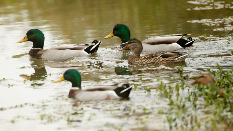
Mallard Hot Spot Shifts as Season Draws to Close on Friday
LITTLE ROCK – Mallards shifted locations in the Delta in the two weeks between between the Arkansas Game and Fish Commission’s midwinter aerial waterfowl survey and the fourth and final survey of the season, completed last week. The Lower St. Francis survey zone, the hot spot for the midwinter survey, was still hosting high humbers of mallards, but the estimates were only about half of what had been surveyed Jan. 6-9. Rather, the Black-Upper White River survey zone rose sharply, likely in response to widespread habitat availability brought about by overbank flooding along the Black River and other watercourses.
Time is running short on the season. Arkansas waterfowlers have until sunset Friday, when the regular season closes. A Youth Hunt and a Veterans/Active Military Hunt is scheduled statewide for Feb. 8. Light goose (snows, blues, Ross’s) may still be hunted nearly every day (except Feb. 8) through April 25, thanks to the Light Goose Conservation Order, which goes into effect Saturday, Feb. 1. However, the season on greater white-fronted geese (specks) also ends on Friday at sunset.
AGFC staff conducted the final aerial waterfowl survey of the 2019-20 wintering period Jan. 17 in the Arkansas River Valley, Jan. 20 in southwest Arkansas and Jan. 20-24 in the Mississippi Alluvial Valley (Delta). Survey estimates for the Delta totaled slightly over 1 million total ducks in the Delta, including 546,885 mallards. A total of 13,000 of the approximately 25,000 ducks estimated in the Arkansas River Valley were mallards. Observers noted less than 2,000 mallards out of the 18,000-plus ducks in southwest Arkansas. Observers in the Delta estimated about 1 million light geese and about 229,000 greater white-fronted geese during this survey (with the caveat that this survey is not great for estimating goose numbers). Observers were J.J. Abernathy, Jason Carbaugh, Jason Jackson, Cameron Tatom and Alex Zachary.
The Delta mallard population estimate was much lower than the 2010-2020 long-term average, but similar to late-January population estimates over the past several years. The total duck population estimate was slightly below the long-term average. Mallards typically make up 61% of all ducks estimated during this survey, and this year’s mallard composition was somewhat lower than this average at 52%. Dabbling ducks other than mallards accounted for the overwhelming majority of other ducks estimated.
Total duck and mallard density maps available at www.agfc.com will show this distribution pattern, apparently due to mallards and other dabbling ducks responding similar to habitat availability.
The highest mallard population estimates in the Arkansas River Valley were in the western portion of the surveyed area in the West Dardanelle and Frog Bayou survey zones. A non-mallard hotspot was noted in the Fourche la Fave survey zone; this concentration consisted mostly of American green-winged teal. This survey’s mallard count in southwest Arkansas was the lowest on record since the 2009-10 wintering period.
According to Luke Naylor, AGFC waterfowl program coordinator, the survey showed that ducks continued to distribute themselves among available unmanaged habitats as they have throughout much of the wintering period.
“Certainly, ducks were present on traditional managed habitats, and these habitats remain critically important for sustaining waterfowl populations and hunting opportunity,” Naylor said. “However, mallards seemed to be seeking out unmanaged habitats as they have become available this year, likely to avoid hunting pressure while capitalizing on new resources.” Naylor said the last summer’s wet conditions encouraged native wetland plant production in many acres of field edges and reforested sites (e.g. Wetland Reserve Easement lands), resulting in large areas of unmanaged moist-soil habitat which, in wet years, can produce large amounts of seed resources for ducks.
“In fact, observers noted 23% and 25% of mallards in the Arkansas River Valley and Delta, respectively, in moist-soil habitat during this survey. About half of Delta mallards were using agricultural lands,” Naylor said.
* * *
All-Day Hunting in the WMAs
One important change to note about the season beginning Wednesday, Jan. 29 and continuing through sunset Friday, Jan. 31: Hunters may use all of the WMAs that are set up for waterfowl hunting through sunset. Any other time of the season, hunters must be finished hunting at noon and off the WMAs at 1 p.m. All WMAs are available to hunt through Friday sunset. WMAs that would normally be closed on a certain day during a regular week of the season will be open the final three days of the season.
* * *
As noted above, Arkansas’s regular waterfowl season will conclude at sunset Jan. 31. Shooting times are 30 minutes before sunrise until sunset (shooting times are available for Little Rock in the AGFC’s Waterfowl Guidebook; subtract 1 minute for every 9 miles eastward, add 1 minute for every 9 miles westward). The daily duck bag limit is 6, which may include no more than 4 mallards (2 hens), 3 scaup, 3 wood ducks, 1 pintail (a change from last year’s limit of 2), 2 redheads, 2 canvasbacks (a change from last year’s limit of 1), 2 black ducks and 1 mottled duck. Coot daily bag limit is 15. Merganser daily bag limit is 5, of which only 2 may be hooded mergansers. Daily bag limit for snow, blue and Ross’s geese is 20; daily limit for white-fronted geese is 3 and for Canada geese the limit is 2.
* * *
Check out the current habitat conditions for the AGFC’s managed areas for waterfowl (all conditions were reported as of Jan. 29; real-time water levels are available through the USGS for George H. Dunklin Bayou Meto WMA, follow the water gauge link listed for the WMA):
Northeast Arkansas
Big Lake WMA
Map | Water Gauge | Weather Report
When the Ditch 81 extension gauge near Manila (upstream of the Big Lake north-end control structure) reads 17.5 feet, water is beginning to come over the north levee degrade on Big Lake WMA. When the Ditch 81 Extension gauge reads 18.0 feet or higher, the water level on the WMA will rise quickly and hunters should exercise caution while on the area. Be aware of underwater logs in boat runs and hangers in trees.
North Woods GTR
Habitat: Mast production is good.
Water Level: Bo Dock guage currently reads 237.0 feet msl; target level is 235.5 feet with 100% flooded.
South Woods GTR
Habitat: Mast production is fair.
Water Level: The 7-Mile gauge is currently reads 236.2 feet msl; target level is 234.5 feet with 100% flooded.
Simmons Field
Habitat: Good production of millet and sedge. Native vegetation is very good in north unit middle fields with 5 acres of millet planted in the north field. The south field was strip planted in Japanese millet leaving strips of wild millet and sedge that did extremely well. On Nov. 22, one-third of the north field and one-third of the middle field were stripped-rolled with a cleated roller.
Water Level: 100% coverage.
Dave Donaldson Black River WMA
Map | Water Gauge | Weather Report
Waterfowl hunters should be aware of hangers and submerged logs within the boat runs and GTRs. Please exercise caution when accessing the area. Please remember to keep boats off the levees so AGFC personnel can access the area. Boats blocking access will be moved. Unattended trailers are not to be left overnight on parking areas. River level is 11.19 feet and holding as of Monday, Jan. 27.
Upper Island GTR
Habitat: Mast crop is moderate within the GTRs.
Water Level: Gauge is inaccessible due to flooding. Target level is 269.5, 100% flooded.
Lower Island GTR
Habitat: Mast crop is moderate within the GTRs.
Water Level: Gauge is inaccessible due to flooding. Target level is 268.0. 100% flooded.
Upper Reyno GTR
Habitat: Mast crop is moderate within the GTRs.
Water Level: Current level is 267.8 feet msl. Target level is 266.9. 100% flooded.
Lower Reyno GTR
Habitat: Mast crop is moderate within the GTRs.
Water Level: Current level is 267.3 feet msl. Target level is 266.3 feet msl. 100% flooded.
Winchester GTR
Habitat: Mast crop is moderate within the GTRs.
Water Level: Current level is 264.9 feet msl. Target level is 263.7. 100% flooded.
Earl Buss Bayou DeView WMA
Map | Water Gauge | Weather Report
Boaters should use caution while using the Thompson Tract boat run.
South Oliver GTR
Habitat: Mast production has been good.
Water Level: 100% flooded with a current gauge reading of 2.0 feet.
Thompson Tract GTR
Habitat: Mast production has been good.
Water Level: 100% flooded with a current gauge reading of 1.7 feet.
Lake Hogue WRA
Habitat: Primarily deep open water habitat.
Water Level: Normal pool level.
Shirey Bay Rainey Brake WMA
Map | Water Gauge | Weather Report
Waterfowl hunters should be aware of hangers and submerged logs within the boat runs and GTRs. Please exercise caution when accessing the area. In addition, hunters should allow safe passage when parking vehicles along roadsides. Vehicles blocking access will be moved.
Adam Brake GTR
Habitat: Mast production is good.
Water Level: Water level is 240.2 feet msl with a target level of 240.0 msl. 100% flooded.
Rainey Brake GTR
Habitat: Mast production is good.
Water Level: 100% flooded.
Eagle Pond GTR
Habitat: Mast production is good.
Water Level: 100% flooded.
Phase III Moist-Soil Unit
Habitat: Good wetland-type vegetation.
Water Level: 45% flooded.
Charles Crisp Moist-Soil Unit
Habitat: Good wetland-type vegetation.
Water Level: 100% flooded.
Ward Field Moist-Soil Unit
Habitat: Good wetland-type vegetation.
Water Level: 100% flooded.
River Field Moist-Soil Unit
Habitat: Good wetland-type vegetation.
Water Level: 100% flooded.
St. Francis Sunken Lands WMA
Map | Water Gauge | Weather Report
Hunt Area
Habitat: Mast production is good within the hunt area.
Water Level: Water levels on St. Francis Sunken Lands for waterfowl season are dependent on flows from St. Francis River. The target level for providing huntable timber is 212.0 feet msl reading from the Oak Donnick gauge. Current reading as of Monday, Jan. 27, is 216.13 feet msl.
Snowden WRA
Habitat: Mixed grasses. There was a small green-up response of wetland plants after the growing season burns throughout the unit.
Water Level: 20% flooded, mostly in the low-lying areas due to rain.
Payneway WRA
Habitat: A, B, C D pools have mixed smartweed and barnyard grasses. Mowing was completed for waterfowl use in pools B and C. Several oaks are producing acorns within pools A, B ande C as well.
Water Level: Pool A is at 20% coverage. Pool B is at 30%. Pool C is at 40%. Pool D is at 50%.
bar
East-Central Arkansas
Henry Gray Hurricane Lake WMA
Map | Water Gauge | Weather Report
Hunters should call the Wildlife Hotline at 800-440-1477 for current road closures.
North GTR
Habitat: Good mast crop.
Water Level: The current Glaise Creek reading is 196.39 feet msl.
Note: All structures on the North GTR are closed.
South GTR
Habitat: Fair mast crop.
Water Level: The current Glaise Creek reading is 196.39 feet msl.
Note: All structures on the South GTR are open.
Rex Hancock Black Swamp WMA
Map | Water Gauge | Weather Report
Hunters should call the Wildlife Hotline at 800-440-1477 for current road closures.
Main WMA
Habitat: Good mast crop.
Water Level: 60% coverage (currently, the Cache River level is 9.7 feet on the Patterson Gauge).
Wyeville Unit
Habitat: Good stand of millet and native vegetation,
Water Level: 100% coverage.
Sheffield Nelson Dagmar WMA
Map | Water Gauge | Weather Report
The Conway George units are available by applying for online permits. Please visit www.agfc.com for maps, special regulations, permit application and draw dates. Hunters should call the Wildlife Hotline at 800-440-1477 for current road closures.
Mud Slough GTR
Habitat: Good mast crop.
Water Level: 65% coverage.
Apple Lake WRA
Habitat: Good mast crop.
Water Level: 90%
Conway George Waterfowl Unit A
Habitat: Good stand of millet and native vegetation.
Water Level: 100%
Conway George Waterfowl Unit B
Habitat: Natural slough area with beneficial wetland palnts.
Water Level: 100%
Conway George Waterfowl Unit C
Habitat: Good stand of millet and native vegetation.
Water Level: 100%
Steve N. Wilson Raft Creek Bottoms WMA
Map | Water Gauge | Weather Report
NOTE: Raft Creek WMA is open to waterfowl hunting Tuesday through Friday this week. Hunting will be allowed all day on Wednesday, Thursday and Friday.
Unit A
Habitat: Excellent stand of native vegetation.
Water Level: 100% coverage.
Unit B
Habitat: Excellent stand of millet and native vegetation.
Water Level: 100%
Unit C
Habitat: Good stand of native vegetation.
Water Level: 100%
Unit D (Youth Area)
Habitat: Good stand of native vegetation.
Water Level: 100%
Unit E
Habitat: Excellent stand of millet and native vegetation.
Water Level: 100%
Unit F
Habitat: Good stand of millet and native vegetation.
Water Level: 100%
Unit G
Habitat: Fair stand of millet and native vegetation.
Water Level: 100%
Unit H (Mobility-impaired blind)
Habitat: Excellent stand of native vegetation.
Water Level: 100%
Unit I
Habitat: Habitat conditions are poor.
Water Level: 100%
Unit J (Cypert Tract)
Habitat: Excellent stand of native vegetation.
Water Level: 100%
Unit K (Cypert Tract)
Habitat: Excellent stand of native vegetation.
Water Level: 100%
Unit L (Cypert Tract)
Habitat: Fair stand of native vegetation.
Water Level: 100%
Central Arkansas
Bell Slough WMA
Map | Weather Report
The Bell Slough GTR is primarily rainfall dependent with the exception of a limited amount of water that the AGFC can back in and catch from Palarm Creek.
Bell Slough GTR
Habitat: Moderate mast crop.
Water Level: 100% flooded.
Palarm Creek WRA
Habitat: Millet was planted as a cover crop this year following disking within the moist-soil units.
Water Level: 100% flooded.
Craig D. Campbell Lake Conway Reservoir
Map | Weather Report
Habitat and water levels are normal on both Pierce and Dix creeks.
Cypress Bayou WMA
Hunt Area
Habitat:
Good mast crop
Water Level: 100% coverage.
Red Cut Slough Tract
Unit 1
Habitat: Good stand of millet and native vegetation.
Water Level: 100%
Unit 2
Habitat:
Excellent stand of millet and native vegatation.
Water Level: 100%
Unit 3
Habitat:
Good stand of millet and native vegetation.
Water Level: 100%
Unit 4
Habitat:
Good stand of millet and native vegetation.
Water Level: 100%
Unit 5
Habitat:
Good stand of native vegetation.
Water Level: 80%
Unit 6
Habitat:
Good stand native vegetation.
Water Level: 80%
Harris Brake WMA
NOTE: Harris Brake WMA is open to waterfowl hunting Wednesday through Friday this week. Hunting will be allowed all day on Wednesday, Thursday and Friday.
Haarris Brake Upper Unit
Habitat: Good hard mast production within the GTR.
Water Level: 100%
Harris Brake Lower Unit
Habitat: Good hard mast production within the GTR.
Water Level:
95% flooded.
Holland Bottoms WMA
Hunt Area
Habitat: Good mast crop.
Water Level: 50%
Lake Pickthorne WRA
Habitat: Excellent.
Water Level: East cell is 100% coverage. West cell is 100%.
Northwest Arkansas
Dardanelle WMA
McKennon Bottoms (half-day hunting)
Habitat: Heavy stand of perennial vegetation due for disking next spring.
Water Level: 100%
Potter’s Pothole Hartman Waterfowl Unit (half-day hunting)
Habitat: Some planted millet, good stand of native millet, sprangletop, panic grasses.
Water Level: 100%
Ed Gordon Point Remove WMA
All waterfowl impoundments on Ed Gordon Point Remove WMA remain at or beyond full pool at this time. Duck use and hunter success on the WMA has been moderate.
Little Hole (Unit 1)
Habitat: Naive vegetation.
Water Level: 100% coverage.
Willow Island (Unit 2)
Habitat: Japanese millet.
Water Level: 100%
Red Gate (Unit 3)
Habitat: Naive vegetation.
Water Level: 100%
Pig Trough (Units 4 and 5)
Habitat: Native vegetation and Japanese and Chiwappa millet.
Water Level: 100%
Cedar Ridge (Unit 6)
Habitat: Japanese and Chiwappa millet, native vegetation.
Water Level: 100%
Unit 7a
Habitat: Japanese millet, native vegetation.
Water Level: 100%
Unit 7b
Habitat: Native vegetation.
Water Level: 100%
Duck Trap (Units 8a, 8b and 8c)
8a
Habitat: Native vegetation.
Water Level: 100%
8b
Habitat: Japanese and Chiwappa millet, native vegetation.
Water Level: 100%
8c
Habitat: Japanese millet.
Water Level: 100%
Unit 9
Habitat: Japanese millet.
Water Level: 100%
Controversy Corner (Unit 10)
Habitat: Native vegetation.
Water Level: 100%
Remmel Marsh
Habitat: Planted Japanese millet, native vegetation.
Water Level: 100%
Mud Pond (Unit 12)
Habitat: Native vegetation.
Water Level: 100%
Turkey Pond (Units 13a, 13b and 13c)
13a
Habitat: Native vegetation and Japanese millet.
Water Level: 100%
13b
Habitat: Native vegetation.
Water Level: 100%
13c
Habitat: Japanese and Chiwappa millet, native vegetation.
Water Level: 100%
Teeny Pond (Unit 14)
Habitat: Native vegetation.
Water Level: 100%
Salt Lick (Unit 15)
Habitat: Native vegetation.
Water Level: 100%
Bobby’s Pond (Unit 16)
Habitat: Japanese millet.
Water Level: 100%
Race Track (Unit 17)
Habitat: Native vegetation.
Water Level: 100%
Frog Bayou WMA (half-day hunting)
Unit 1
Habitat: Sprangletop, wild millet, smartweed and nutsedge
Water Level: 100%
Unit 2
Habitat: Good stand of barnyard grass and nutsedge.
Water Level: 50%
Unit 3
Habitat: Smartweed, toothcup, nutsedge, barnyard grass, sprangle top and duck potato.
Water Level: 100%
Unit 4
Habitat: Barnyard grass, sprangletop, annual smartweed, nutsedge and crabgrass.
Water Level: 100%
Unit 5
Habitat: Sprangletop, wild millet, smartweed, knotgrass, nutsedge and duck potato..
Water Level: 100%
Unit 6
Habitat: Barnyard grass, smartweed, crabgrass and sprangletop.
Water Level: 100%
Unit 7
Habitat: Lower end of unit planted with millet, upper end with barnyard grass, sprangle top and smartweed.
Water Level: 100%
bar
Galla Creek WMA
Galla Creek GTR
Habitat: Moderate stand of native vegetation, including a mixture of barnyard grass and sprangletop. Duck use and hunter success on the WMA has been low to moderate.
Water Level: 100%, staged flooding of the impoundment began on Nov. 12, 2019, and the waterfowl impoundment is at full pool at this time.
Nimrod Lloyd Millwood WMA
Nimrod GTR
Habitat: This area produced a great mast crop this year with a mix of moderate to good stands of desirable native vegetation throughout the open lands.
Water Level: 100% flooded.
Ozark Lake WMA/Dyer Lake Water Unit
Dyer Lake Cells (half-day hunting)
Habitat: Fair stand of nutsedge, toothcup, smartweed and sprangletop. Unit 3 was impacted by summer flooding and is in need of disturbance, which is scheduled for next year.
Water Level: Units 1 and 2, 100%. Units 3 (rainfall dependent) 100%.
Petit Jean River WMA
Map | Water Gauge | Weather Report
Sorehead Moist-Soil Unit
Habitat: This unit contains a mix of moderate to good stands of desirable native vegetation throughout..
Water Level: 100%
Blacklands Moist-Soil Unit
Habitat: This area contains a mix of poor to great stands of desirable native vegetation throughout. The wooded areas inside the unit produced a great mast crop this year.
Water Level: 100%
Slaty Crossing Moist-Soil Unit
Habitat: Due to ongoing waterfowl habitat enhancement projects, this unit has only small stands of native vegetation. The majority of this unit is bare ground.
Water Level: 90%
Blacklands Duck Area
Habitat: The wooded sections of this area produced a great mast crop this year. This area also contains a mix of moderate to great stands of desirable native vegetation mixed throughout.
Water Level: 100%
Pullen Pond Marsh
Habitat: Due to ongoing waterfowl habitat enhancement projects, parts of the southern and western sections of this area are bare ground. The western section of this area has spotted sections of great desirable native vegetation. The northern section of the area only produced poor stands of native vegetation.
Water Level: 100%
Pond Creek GTR
Habitat: This area produced a great mast crop this year with great stands of desirable mative vegetation in the open lands within this area,
Water Level: 0%
Slaty GTR
Habitat: This area produced a great mast crop this year.
Water Level: 10%
Santa Fe GTR
Habitat: This area produced a great mast crop this year.
Water Level: 100%
Southwest Arkansas
Dr. Lester Sitzes III Bois d’Arc WMA
Bois d’Arc Lake WRA
Habitat: Closed to hunting.
Water Level: Normal
Red Slough WRA
Habitat: Closed to hunting.
Water Level: 55%
GTR
Habitat: Good mast production.
Water Level: 80%.
Little Grassy
Habitat: Good
Water Level: 70%
Millwood Lake
Map | Water Gauge | Weather Report
Habitat: Habitat conditions are good.
Water Level: 261.07 feet msl.
Ozan WMA
Unit 1
Habitat: Good
Water Level: 40%
Unit 2
Habitat: Good
Water Level: 0%
Unit 3
Habitat: Good
Water Level: 45%
Unit 4
Habitat: Good
Water Level: 0%
Unit 5
Habitat: Good
Water Level: 15%
Sulphur River WMA
Mercer Bayou
Habitat: Fair
Water Level: Low, no boat access.
Henry Moore WRA
Habitat: Closed to hunting.
Water Level: 35%
Southeast Arkansas
Beryl Anthony Lower Ouachita WMA
Map | Weather Report
Habitat: The WMA has a good hard mast production.
Water Level: The WMA is about 60% flooded.
Cut-Off Creek WMA
Hunt Area
Habitat: Habitat conditions are good.
Water Level: Fully flooded.
Pigeon Creek WRA
Habitat: Habitat conditions are good.
Water Level: Fully flooded.
Freddie Black Choctaw Island WMA Deer Research Area
Map | Water Gauge | Weather Report
Habitat conditions are good. Flooding is river dependent. Click on the Water Gauge link above for current Mississippi River levels. Use extreme caution when boating in river.
George H. Dunklin Jr. Bayou Meto WMA
Map | Water Gauge | Weather Report
The UGSG is now reporting real-time water gauge readings at the headwater at each GTR within the George H. Dunklin Bayou Meto WMA. Click the Water Gauge link above for the WMA, and search for the particular GTR as noted. As of Jan. 6, all gauges in all GTRs were at full pool.
Upper Vallier GTR
Habitat: Good
Water Level: See Gauge Link (Upper Vallier Headwater)
Lower Vallier GTR
Habitat: Good
Water Level: See Gauge Link (Lower Vallier Headwater)
Government Cypress GTR
Habitat: Good
Water Level: See Gauge Link (Government Cypress Headwater)
Buckingham Flats GTR
Habitat: Good
Water Level: Pumping complete. See Gauge Link (Buckingham Flats Headwater).
Temple Island GTR
Habitat: Good
Water Level: Pumping complete. See Gauge Link (Temple Island Headwater).
Canon Brake
Habitat: Good
Water Level: See Gauge Link (Canon Brake Headwater).
Halowell WRA
Habitat: Excellent
Water Level: Staggered flooding of units, 75% flooded.
Wrape Plantation WRA
Habitat: Excellent
Water Level: Staggered flooding of units.
Seven Devils WMA
Hunt Area
Habitat: Habitat conditions are good.
Water Level: Fully flooded.
Trusten Holder WMA
Map | Water Gauge | Weather Report
Habitat conditions are good. Flooding is river dependent. Click on the Water Gauge link above for current Arkansas River levels.
Recent News

Subscribe to Our Weekly Newsletter E-mails
Don’t miss another issue. Sign up now to receive the AGFC Wildlife Weekly Newsletter in your mailbox every Wednesday afternoon (Waterfowl Reports are published weekly during waterfowl season and periodically outside the season). Fishing Reports arrive on Thursdays. Fill in the following fields and hit submit. Thanks, and welcome!